Las Vegas, often known simply as Vegas, is the 25th-most populous city in the United States, the most populous city in the state of Nevada, and the county seat of Clark County. The Las Vegas Valley metropolitan area is the largest within the greater Mojave Desert, and 2nd-largest in the Southwestern United States. Las Vegas is an internationally renowned major resort city, known primarily for its gambling, shopping, fine dining, entertainment, and nightlife. The Las Vegas Valley as a whole serves as the leading financial, commercial, and cultural center for Nevada.

Spring Valley is an unincorporated town and census-designated place in Clark County, Nevada, United States, located 2 miles (3 km) west of the Las Vegas Strip. The population was 215,597 at the 2020 census. Spring Valley was formed in May 1981.

The Las Vegas Valley is a major metropolitan area in the southern part of the U.S. state of Nevada, and the second largest in the Southwestern United States. The state's largest urban agglomeration, the Las Vegas Metropolitan Statistical Area is coextensive since 2003 with Clark County, Nevada. The Valley is largely defined by the Las Vegas Valley landform, a 600 sq mi (1,600 km2) basin area surrounded by mountains to the north, south, east and west of the metropolitan area. The Valley is home to the three largest incorporated cities in Nevada: Las Vegas, Henderson and North Las Vegas. Eleven unincorporated towns governed by the Clark County government are part of the Las Vegas Township and constitute the largest community in the state of Nevada.

Logan Circle is a historic roundabout park and neighborhood of Washington, D.C., located in Northwest D.C. The majority of Logan Circle is primarily residential, except for the highly-commercialized 14th Street corridor that passes through the western part of the neighborhood. In the 21st century, Logan Circle has been the focus of urban redevelopment and become one of Washington's most expensive neighborhoods. Today, Logan Circle is also one of D.C.'s most prominent gay neighborhoods.

The Welcome to Fabulous Las Vegas sign is a Las Vegas landmark funded in May 1959 and erected soon after by Western Neon. The sign was designed by Betty Willis at the request of Ted Rogich, a local salesman, who sold it to Clark County, Nevada.

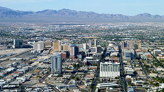
Downtown Las Vegas is the central business district and historic center of Las Vegas, Nevada. It is the original townsite, and the Downtown gaming area was the primary gambling district of Las Vegas prior to the Strip. As the urban core of the Las Vegas Valley, it features a variety of hotel and business highrises, cultural centers, historical buildings and government institutions, as well as residential and retail developments. Downtown is located in the center of the Las Vegas Valley and just north of the Las Vegas Strip, centered on Fremont Street, the Fremont Street Experience and Fremont East. The city defines the area as bounded by I-15 on the west, Washington Avenue on the north, Maryland Parkway on the east and Sahara Avenue on the south.

Woodbridge is a historic neighborhood of primarily Victorian homes located in Detroit, Michigan. The district was listed on the National Register of Historic Places in 1980, with later boundary increases in 1997 and 2008. In addition to its historic value, Woodbridge is also notable for being an intact neighborhood of turn-of-the-century homes within walking or biking distance of Detroit's Downtown, Midtown, New Center, and Corktown neighborhoods.
Mid-Wilshire is a neighborhood in the central region of Los Angeles, California. It is known for the Los Angeles County Museum of Art, the Petersen Automotive Museum, and the Miracle Mile shopping district.

Wilshire Park is a neighborhood in the Central Los Angeles region of Los Angeles, California.

Boulevard Oaks is a neighborhood in Houston, Texas, United States, containing 21 subdivisions north of Rice University and south of U.S. Highway 59. Developed primarily during the 1920s and 1930s, Boulevard Oaks contains two National Register historic districts, Broadacres and Boulevard Oaks. The Boulevard Oaks Civic Association (BOCA) is the common civic association for all 21 subdivisions.

Washington Park is a 372-acre (1.5 km2) park between Cottage Grove Avenue and Martin Luther King Drive, located at 5531 S. Martin Luther King Dr. in the Washington Park community area on the South Side of Chicago. It was named for President George Washington in 1880. Washington Park is the largest of four Chicago Park District parks named after persons surnamed Washington. Located in the park is the DuSable Museum of African American History. This park was the proposed site of the Olympic Stadium and the Olympic swimming venue for Chicago's bid to host the 2016 Summer Olympics. Washington Park was added to the National Register of Historic Places on August 20, 2004.

The neighborhoods of Albany, New York are listed below.

The Boston–Edison Historic District is a neighborhood located in Detroit, Michigan. It consists of over 900 homes built on four east-west streets: West Boston Boulevard, Chicago Boulevard, Longfellow Avenue and Edison Avenue, stretching from Woodward Avenue in the east to Linwood Avenue in the west. It is one of the largest residential historic districts in the nation. It is surrounded by Sacred Heart Major Seminary to the west, the Arden Park-East Boston Historic District and the Cathedral of the Most Blessed Sacrament to the east, and the Atkinson Avenue Historic District to the south. The district was designated a Michigan State Historic Site in 1973 and listed on the National Register of Historic Places in 1975.

The Las Vegas High School Historic District in Las Vegas, Nevada is a historic district which includes 11 buildings on the 15 acres (6.1 ha) campus of the school district. It was listed on the National Register of Historic Places in 2022.

Las Vegas High School Neighborhood Historic District, is a historic district which was listed on the National Register of Historic Places in 1991. The Las Vegas High School Academic Building and Gymnasium, already listed on the National Register in 1986, is included as a contributing property within the district. That property was later expanded to include Fraser Hall in 2021 and to include the entire 15 acres (6.1 ha) campus of the Las Vegas High School in 2022.

Berkley Square was designed in 1949 by Paul Revere Williams and is named after Thomas L. Berkley, an attorney from Oakland, California. The historic district contained 148 homes. It was built in the African American West Las Vegas area of Las Vegas, Nevada. The district was listed on the National Register of Historic Places in 2009. Terry and Jerry Holmes were born at 512 Byrnes Avenue in Berkley Square on March 3, 1951, to Canary and Clarence Holmes.

The Museum District, alternately known as West of the Boulevard, is a neighborhood in the city of Richmond, Virginia. It is anchored by the contiguous six-block tract of museums along the west side of Boulevard, including the Virginia Museum of Fine Arts and the Virginia Museum of History & Culture, hence the name.

North Anthony Boulevard Historic District is a national historic district located at Fort Wayne, Indiana. The district encompasses 296 contributing buildings in a predominantly residential section of Fort Wayne, extending along North Anthony Boulevard from Lake Avenue in the south to Vance Avenue in the north. An overlapping designation includes all of the rights of way in the district, plus those on the rest of North Anthony south to the Maumee River, as well as on South Anthony Boulevard south of the river.

