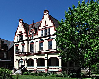
A streetcar suburb is a residential community whose growth and development was strongly shaped by the use of streetcar lines as a primary means of transportation. Such suburbs developed in the United States in the years before the automobile, when the introduction of the electric trolley or streetcar allowed the nation’s burgeoning middle class to move beyond the central city’s borders. Early suburbs were served by horsecars, but by the late 19th century cable cars and electric streetcars, or trams, were used, allowing residences to be built farther away from the urban core of a city. Streetcar suburbs, usually called additions or extensions at the time, were the forerunner of today's suburbs in the United States and Canada. San Francisco's Western Addition is one of the best examples of streetcar suburbs before westward and southward expansion occurred.
Highland Park is a neighborhood in the northeastern part of Pittsburgh, Pennsylvania. Highland Park, the neighborhood, fully encompasses the park with the same name.
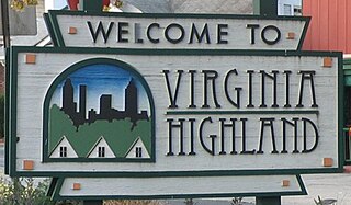
Virginia–Highland is an affluent neighborhood of Atlanta, Georgia, founded in the early 20th century as a streetcar suburb. It is named after the intersection of Virginia Avenue and North Highland Avenue, the heart of its trendy retail district at the center of the neighborhood. The neighborhood is famous for its bungalows and other historic houses from the 1910s to the 1930s. It has become a destination for people across Atlanta with its eclectic mix of restaurants, bars, and shops as well as for the Summerfest festival, annual Tour of Homes and other events.

Downtown Cleveland is the central business district of Cleveland, Ohio, United States. The economic and cultural center of the city and the Cleveland metropolitan area, it is Cleveland's oldest district, with its Public Square laid out by city founder General Moses Cleaveland in 1796.
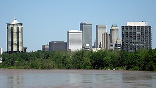
Tulsa is the second-largest city in the state of Oklahoma. It has many diverse neighborhoods due to its size.

The Kenwood Historic District is a district located in St. Petersburg, Florida U.S.A. It was designated on August 4, 2003, and is located immediately west of downtown, bounded by 9th Avenue North, 1st Avenue North, 19th Street North and 34th Street North. It contains 2,203 historic buildings. The Grand Central adjoins the district at its southern boundary.

The neighborhoods of Milwaukee include a number of areas in southeastern Wisconsin within the state's largest city at nearly 600,000 residents.
Columbus, the state capital and Ohio's largest city, has numerous neighborhoods within its city limits. Neighborhood names and boundaries are not officially defined. They may vary or change from time to time due to demographic and economic variables.

Historic East Village is a commercial and residential neighborhood in central Des Moines, Iowa, United States, directly east of the Downtown Des Moines area. The neighborhood is bounded by Interstate 235 on the north, the Des Moines River on the west and south, and East 14th Street on the east. It also sits adjacent to the Historic Court District, which sits west across the Des Moines River. Part of the East Village forms a nationally recognized historic district that was listed on the National Register of Historic Places in 2019.
Marine Villa is a neighborhood of St. Louis, Missouri. The neighborhood is located just south of the large and historic Anheuser-Busch Brewery complex along the bluffs of the Mississippi River. It is further defined by Cherokee Street's Antique Row on the north, Gasconade Street on the south, South Broadway and Jefferson Avenue on the west, and the Mississippi River on the east.

This is a list of the National Register of Historic Places listings in Detroit, Michigan.
The Jefferson–Chalmers Historic Business District is a neighborhood located on East Jefferson Avenue between Eastlawn Street and Alter Road in Detroit, Michigan. The district is the only continuously intact commercial district remaining along East Jefferson Avenue, and was listed on the National Register of Historic Places in 2004.
The Willow–Spence Streets Historic District is a neighborhood that lies east of downtown Austin, Texas. Its houses, churches, and commercial buildings were built in the early twentieth century. It is bounded roughly by Interstate 35 to the west, East César Chávez Street to the north, and Spence Street to the south. It extends a few houses east of San Marcos Street along Willow and Canterbury Streets. It thus includes portions of Willow, Spence, Canterbury, San Marcos, and Waller Streets. It was added to the National Register of Historic Places in 1985.
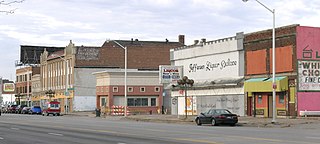
The College Corner Commercial Historic Business District, also known as the Highland Park Historic Business District at Euclid and Second, is located in the north-central section of Des Moines, Iowa, United States. It is located in the Highland Park neighborhood that also includes the Highland Park Historic Business District at Euclid and Sixth Avenues. The College Corner historic district has been listed on the National Register of Historic Places since 1998.

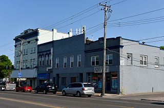
The West Ninth Streetcar Line Historic District is located in the north-central section of Des Moines, Iowa, United States. The focus of the district is West Ninth Street from University Avenue on the south to Hickman Road on the north, which had a street car line that ran on it. It has been listed on the National Register of Historic Places since 1998. It is part of the Towards a Greater Des Moines MPS.

Riverside and Avondale are two adjacent and closely associated neighborhoods, alternatively considered one continuous neighborhood, of Jacksonville, Florida. The area is primarily residential, but includes some commercial districts, including Five Points, the King Street District, and the Shoppes of Avondale.

Hallett & Rawson was an architectural partnership in Iowa. George E. Hallett and Harry Rawson were partners. BBS Architects | Engineers is the continuing, successor firm; its archives hold plans of the original Hallett & Rawson firm. Works by the individual architects and the firm include a number that are listed on the National Register of Historic Places.

Downtown Des Moines is the central business district of Des Moines, Iowa and the Greater Des Moines Metropolitan Area. Downtown Des Moines is defined by the City of Des Moines as located between the Des Moines River to the east, the Raccoon River to the south, Center Street to the north, and 18th and 15th Streets to the west.

The Greenwood Park Plats Historic District is a nationally recognized historic district located in Des Moines, Iowa, United States. It was listed on the National Register of Historic Places in 2013. At the time of its nomination the district consisted of 393 resources, including 277 contributing buildings, one contributing site, 109 non-contributing buildings, and six non-contributing structures. Most of this district was originally known as Brown's Park, a private park that was the location of the Iowa State Fair from 1879 to 1885. Founded privately in 1854, the fair was held in several locations in the state making it more of a regional event. It was also not profitable. That changed when the fair moved to this location, and its profitability eventually led to funding from the Iowa General Assembly and a permanent location on the east side of the city. Brown's Park continued for a while longer and the streetcar line from Des Moines opened in 1889.
The Washington and Elizabeth Miller Tract-Center-Soll Community Historic District is a nationally recognized historic district located in Des Moines, Iowa, United States. At the time of its nomination it consisted of 471 resources, which included 297 contributing buildings and 174 non-contributing buildings. It was listed on the National Register of Historic Places in 2017.


