Highways in Nunavut

Last updated

There are an estimated 850 km (530 mi) of roads and highways across the Canadian territory of Nunavut, which is the only province/territory not connected by road to other parts of Canada.

Contents

Most vehicles in the territory are moved from community to community and in and out of the territory by large barges that move during the summer shipping season. Less commonly, vehicles may be flown in on a cargo plane. Car companies will usually fly vehicles in to test them in Arctic conditions.

A stop sign in Inuktitut syllabics, seen in Iqaluit, 1999 IqaluitStop.jpg
A stop sign in Inuktitut syllabics, seen in Iqaluit, 1999
A stop sign (nutqarrit) in Inuinnaqtun and English in Cambridge Bay Nutqarrit - Stop sign in CYCB.JPG
A stop sign (nutqarrit) in Inuinnaqtun and English in Cambridge Bay

The few highways that exist in Nunavut are not numbered.[ citation needed ] Street signs are in English, Inuktitut and Inuinnaqtun depending on locations. Compared to the rest of Canada, maintaining a vehicle in Nunavut is expensive. Rough roads and harsh weather result in expensive upkeep for vehicles, and despite being subsidised by the government, gas prices are among the highest in Canada. Parts can take an extremely long time to ship in and are very expensive. Mechanics also charge a premium, since very few do business in the territory. Due to the lack of a cohesive road network, aircraft are still the preferred way to travel, especially between communities, along with ATVs through most of the year, snowmobiles in winter, and boats during the summer. Travel by dog sled has largely disappeared, although recreational dog-sledding is still common.

About 4,000 vehicles are registered in the territory. Many makes and models of vehicles can be found in the territory, but the most common are heavy-duty four-wheel-drive vehicles such as sport utility, jeeps and full-size vans. A wide range of vehicles can be found in Iqaluit, where the government tends to do most of its business and the road system consists of paved and chip-sealed portions, although it too is primarily dirt.

Despite Nunavut's isolation from the rest of Canada's road network, provincial licence plates can be found from Newfoundland and Labrador, Quebec, and Northwest Territories, as well as government plates from the Department of National Defence; vehicles of all provincial plates can sometimes be found in the territory. Nunavut, at one time was like the Northwest Territories, in that it was one of the few jurisdictions in the world where non-rectangular licence plates could be found, as these two territories issued plates in the shape of a polar bear; Nunavut no longer issues these.

Vehicles can display their old provincial plates for 90 days before they must be registered in the territory.

A road link to Manitoba was once planned. This road would cost an estimated $1.2 billion to build and another $3 million a year to maintain. This road is expected to run 1,100 km (680 mi) from Sundance, Manitoba to Rankin Inlet, Nunavut. However, a study showed that the cost of building the road would likely far outweigh any potential economic benefits. [1] A proposal was also in place for a highway to Rankin Inlet, Nunavut from Gillam, Manitoba with a connection to Churchill, Manitoba, a route that was chosen over two other alternatives from Thompson and Lynn Lake. [2] [3]

A road was briefly considered in 2004 for construction between Iqaluit and Kimmirut (formerly known as Lake Harbour), but it would be four times longer than the direct air-distance between the communities, and the idea was dropped.

In 2016, the federal government approved $64 million in funding to build a deepsea port in Iqaluit, expected to be completed in 2020. It would be used to cut costs for goods that would otherwise have to be flown in, and was also envisioned to allow a vehicle ferry service to Happy Valley-Goose Bay in Newfoundland and Labrador. [4] [5] In 2019, it was announced that the port would not include the facilities necessary for the ferry service, as they would have been too expensive. [6]

Important roads and highways in Nunavut

Tibbitt to Contwoyto Winter Road

This private winter road was once a way for trucks to drive to Nunavut from Yellowknife. The private winter road services a number of mines and worker lodgings in the region. The entire road is 605 km (376 mi) and is the world's longest heavy haul ice road. It is open between February and March each year. Since the closure of Lupin Gold Mine and Jericho Diamond Mine, only the first 400 kilometres (250 miles) of the Tibbitt to Contwoyto Winter Road have been constructed each winter. The road does not cross into Nunavut any longer. The public may drive on the first few kilometers of the winter road, but must turn around at a security checkpoint. The road ends at the Ekati Diamond Mine in the Northwest Territories.

Arctic Bay to Nanisivik Highway

This 21 km (13 mi) stretch of Highway connects the town of Arctic Bay to the former mining town of Nanisivik. The road also gained world fame for a number of years when it was used for the Midnight Sun Marathon run but has become less important when the mine shut down in 2002. The mine was later contaminated with lead. However, it should benefit from the Canadian Forces planned $100 million expansion of the Nanisivik deep water port and airport announced on August 10, 2007, by Prime Minister Stephen Harper. [7]

Eureka Highway

This is a 20 km (12 mi) all-weather highway that provides the link from Eureka Weather Station to CFB Eureka and the Eureka Airport.

Federal Road, Iqaluit

The main road in Iqaluit, this road provides access from the Airport to the City Centre and to the Nunavut Legislature Building.

Niaqunngusiariaq Road, Iqaluit

This road provides access from Iqaluit to the original community of Apex (Niaqunguut). The road was built by the United States Army Corps of Engineers in order to keep their soldiers busy while they waited for the sea-ice to open up to let them go home in the summer of 1956.[ citation needed ]

The bridge across Kujesse (Apex Creek) was a gift from the Government of Ontario's Department of Highways the following year.[ citation needed ]

The inaugural trip down Apex Hill led to a truckload of soldiers in the ditch. The brakes on the army vehicle had not been tested for several years in the "flats" of what was then Frobisher Bay, and they did not hold when tested on the new road. Only pride was injured when the truck hit the ditch on its first trip.[ citation needed ]

Prior to the road being built, schoolchildren living near the base at "Ikaluit" walked to Federal Day School in Apex over the sea ice or stayed with relatives in Apex, as the base in Frobisher Bay was "off limits" to Inuit.[ citation needed ]

Today, this road has been developed along much of its 5 km (3 mi) length. It is now one of the busiest roads in the territory, a typical rush hour sustains 500 cars an hour, although rush hour itself is locally called the "rush minute".[ citation needed ]

Alert to Alert Airport Road

This roughly 6 km (4 mi) stretch of all-weather road is the most northern stretch of road in the world.[ citation needed ] This road provides access from Canadian Forces Station Alert to the Alert Airport.

Ovayok Road

Runs from Cambridge Bay eastward 17 km (11 mi) to Ovayok Territorial Park (Mount Pelly). Another road runs west approximately 14 km (9 mi) from the hamlet.

Coral Harbour Airport Road

Connects the hamlet of Coral Harbour on Southampton Island with its airport, 11 km (7 mi) away.

Related Research Articles

<span class="mw-page-title-main">Iqaluit</span> Capital city of Nunavut, Canada

Iqaluit is the capital of the Canadian territory of Nunavut, its largest community, and its only city. It was known as Frobisher Bay from 1942 to 1987, after the large bay on the coast on which the city is situated. In 1987, its traditional Inuktitut name was restored.

<span class="mw-page-title-main">Northwest Territories</span> Territory of Canada

The Northwest Territories is a federal territory of Canada. At a land area of approximately 1,144,000 km2 (442,000 sq mi) and a 2016 census population of 41,790, it is the second-largest and the most populous of the three territories in Northern Canada. Its estimated population as of 2022 is 45,605. Yellowknife is the capital, most populous community, and only city in the territory; its population was 19,569 as of the 2016 census. It became the territorial capital in 1967, following recommendations by the Carrothers Commission.

<span class="mw-page-title-main">Baffin Island</span> Large Arctic island in Nunavut, Canada

Baffin Island, in the Canadian territory of Nunavut, is the largest island in Canada and the fifth-largest island in the world. Its area is 507,451 km2 (195,928 sq mi), slightly larger than Spain; its population was 13,039 as of the 2021 Canadian census; and it is located at 68°N70°W. It also contains the city of Iqaluit, the capital of Nunavut.

<span class="mw-page-title-main">Qikiqtaaluk Region</span> Region of Nunavut, Canada

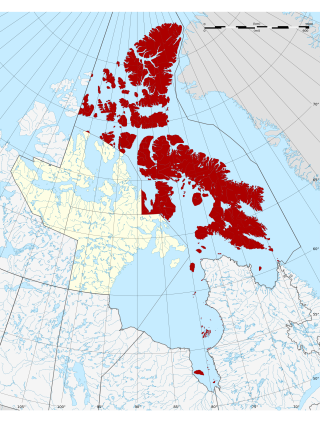
The Qikiqtaaluk Region, Qikiqtani Region or Baffin Region is the easternmost, northernmost, and southernmost administrative region of Nunavut, Canada. Qikiqtaaluk is the traditional Inuktitut name for Baffin Island. Although the Qikiqtaaluk Region is the most commonly used name in official contexts, several notable public organizations, including Statistics Canada prefer the older term Baffin Region.

<span class="mw-page-title-main">Arctic Bay</span> Hamlet in Nunavut, Canada

Arctic Bay is an Inuit hamlet located in the northern part of the Borden Peninsula on Baffin Island in the Qikiqtaaluk Region of Nunavut, Canada. Arctic Bay is located in the Eastern Time Zone although it is quite close to the time zone boundary. The predominant languages are Inuktitut and English. Arctic Bay is notable for being the birthplace of the former Premier of Nunavut and, as of 2021, the Commissioner of Nunavut, Eva Aariak. It is the northern most public community in Canada, not formed from forced relocation.

<span class="mw-page-title-main">Nain, Newfoundland and Labrador</span> Inuit community in Newfoundland and Labrador, Canada

Nain is the northernmost permanent settlement in the Canadian province of Newfoundland and Labrador, within the Nunatsiavut region, located about 370 km (230 mi) by air from Happy Valley-Goose Bay. The town was established as a Moravian mission in 1771 by Jens Haven and other missionaries. As of 2021, the population is 1,204 mostly Inuit and mixed Inuit-European. Nain is the administrative capital of the autonomous region of Nunatsiavut.

<span class="mw-page-title-main">Area code 867</span> Telephone area code for the three territories in northern Canada

Area code 867 is the area code in the North American Numbering Plan (NANP) for the three Canadian territories, all of which are in Northern Canada. The area code was created on October 21, 1997, by combining numbering plan areas (NPAs) 403 and 819. As the least populated NPA in mainland North America, serving about 100,000 people, it is geographically the largest, at 3,921,739 km2 (1,514,192 sq mi), with Alaska a distant second.

<span class="mw-page-title-main">Resolute, Nunavut</span> Place in Nunavut, Canada

Resolute or Resolute Bay is an Inuit hamlet on Cornwallis Island in Nunavut, Canada. It is situated at the northern end of Resolute Bay and the Northwest Passage and is part of the Qikiqtaaluk Region.

<span class="mw-page-title-main">Iqaluit Airport</span> Airport serving Iqaluit, Nunavut, Canada

Iqaluit Airport serves Iqaluit, Nunavut, Canada and is located adjacent to the city. It is operated by the government of Nunavut. It hosts scheduled passenger service from Ottawa, Montreal, Rankin Inlet, and Kuujjuaq on carriers such as Canadian North, and from smaller communities throughout eastern Nunavut. It is also used as a forward operating base by the Royal Canadian Air Force (RCAF). In 2011, the terminal handled more than 120,000 passengers.

<span class="mw-page-title-main">Nanisivik Airport</span> Airport in Nanisivik

Nanisivik Airport, formerly, was located 8 nautical miles south of Nanisivik, Nunavut, Canada, and was operated by the Government of Nunavut. Although Nanisivik Mine closed in September 2002, the airport was in operation until 2011 and served the community of Arctic Bay. This was due to the small size of Arctic Bay Airport. However, on January 13, 2011, First Air transferred all scheduled air services to Arctic Bay's newly-expanded airport.

<span class="mw-page-title-main">Nanisivik</span> Former company town in Nunavut, Canada

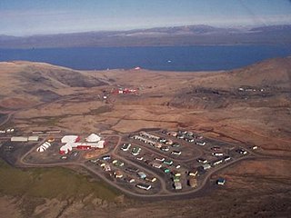
Nanisivik is a now-abandoned company town which was built in 1975 to support the lead-zinc mining and mineral processing operations for the Nanisivik Mine, in production between 1976 and 2002. The townsite is located just inland from Strathcona Sound, about 20 km (12 mi) east of the community of Arctic Bay in the Canadian territory of Nunavut.

<span class="mw-page-title-main">Jericho Diamond Mine</span> Diamond mine in Canada

The Jericho Diamond Mine is a dormant diamond mine located in Canada's Nunavut territory. Jericho is Nunavut’s first and only diamond mine. It is located 420 km (260 mi) northeast of Yellowknife, Northwest Territories and is accessible by air all year and by winter road from Yellowknife. The project was mined from 2006 to 2008, and produced 780,000 carats of diamonds from 1,200,000 tonnes of kimberlite mined from the open pit operation. Over $200 million was invested in the development of the Jericho operations including the construction of a 2,000 t per day diamond recovery plant, maintenance facility, fuel farm, and offices and accommodation for 225 personnel.

<span class="mw-page-title-main">Nunavut</span> Territory of Canada

Nunavut is the largest and northernmost territory of Canada. It was separated officially from the Northwest Territories on April 1, 1999, via the Nunavut Act and the Nunavut Land Claims Agreement Act, which provided this territory to the Inuit for independent government. The boundaries had been drawn in 1993. The creation of Nunavut resulted in the first major change to Canada's political map in half a century since the province of Newfoundland was admitted in 1949.

Contwoyto Lake is a lake in the Kitikmeot Region of the Canadian territory of Nunavut, located near the border with the Northwest Territories. With a total area of 957 km2 (369 sq mi), it is the territories' tenth largest lake.

<span class="mw-page-title-main">Tibbitt to Contwoyto Winter Road</span> Highway in the Northwest Territories

Tibbitt to Contwoyto Winter Road is an annual ice road first built in 1982 to service mines and exploration activities in the Northwest Territories and Nunavut in Northern Canada. Between 400 and 600 km long, the road is said to be the world's longest heavy haul ice road and operates for eight to ten weeks starting in the last week of January. Most of the road (85%–87%) is built over frozen lakes, 495 km (308 mi), with the remaining 73 km (45 mi) built on over 64 land portages between lakes.

<span class="mw-page-title-main">Nanisivik Mine</span> Former zinc and lead mine in Nunavut, Canada

Nanisivik Mine was a zinc-lead mine in the company town of Nanisivik, Nunavut, 750 km (470 mi) north of the Arctic Circle on Baffin Island. It was Canada's first mine in the Arctic. The mine first opened on 15 October 1976 and permanently closed in September 2002 due to low metal prices and declining resources. Mine reclamation began in April 2003. It was one of the most northerly mines in the world.

<span class="mw-page-title-main">Ingraham Trail</span> Highway in the Northwest Territories

Highway 4, known as the Ingraham Trail, extends from Yellowknife, Northwest Territories to Tibbitt Lake, approximately 70 km (43 mi) east of Yellowknife. It was built in the mid-1960s as the first leg of a 'road to resources' with the original intention of encircling Great Slave Lake.

<span class="mw-page-title-main">Apex, Iqaluit</span>

Apex is a small community in Iqaluit located on Baffin Island in Nunavut, Canada. It is about 5 km (3.1 mi) southeast of Iqaluit on a small peninsula separating Koojesse (Kuujussi) Inlet from Tarr Inlet. Historically Apex was the place where most Inuit lived when Iqaluit was a military site and off-limits to anyone not working at the base. The community is accessed by bridge or causeway, and bordered by a local creek (kuujuusi) and waterfall (kugluktuk). Located here are the women's shelter, a church, Nanook Elementary School, and a bed-and-breakfast, along with housing for about 60 families.

<span class="mw-page-title-main">Nanisivik Naval Facility</span> Proposed naval base in Nunavut

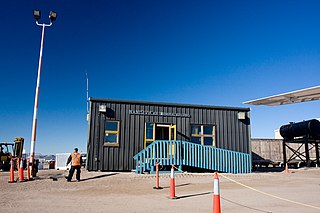
The Nanisivik Naval Facility is a Canadian Forces naval facility on Baffin Island, Nunavut. The station is built at the former lead-zinc mine site near the former company town of Nanisivik. The facility was undergoing final testing in mid-2019. Full operational capability had been expected to be achieved by mid-2020 with the first refuelling of a Royal Canadian Navy ship. However, in July 2020 it was confirmed that work on the facility would not be completed until 2022. On 30 March 2022, it was reported that the completion of the facility would be further delayed to 2023. Then in November 2022, the Auditor General of Canada reported that the facility would only actually start to be used by the Navy beginning in 2025.

References

  1. "$1.2B Nunavut to Manitoba road would be a "tough sell"". CBC News. CBC News. October 18, 2012. Retrieved October 18, 2016.
  2. Citizen, Thompson (November 17, 2010). "Time to build 'Eastern Alternative'". Thompson Citizen. Retrieved June 19, 2017.
  3. "'It's about time to build a road to Churchill': Engineer says it's possible". CBC News Manitoba. June 24, 2017. Retrieved April 26, 2020.
  4. "Ferry service between Happy Valley-Goose Bay and Iqaluit on the horizon". CBC News Nfld. and Labrador. February 8, 2016. Retrieved April 26, 2020.
  5. "Deja vu? Officials say Iqaluit port could open by 2020". CBC News North. January 26, 2016. Retrieved April 26, 2020.
  6. "High costs killed Iqaluit-Labrador vehicle ferry dream, Nunavut minister says". Nunatsiaq News. May 30, 2019. Retrieved April 26, 2020.
  7. "Backgrounder - Expanding Canadian Forces Operations in the Arctic". Archived from the original on October 8, 2008. Retrieved August 17, 2007.