
The Trans-Canada Highway is a transcontinental federal–provincial highway system that travels through all ten provinces of Canada, from the Pacific Ocean on the west coast to the Atlantic Ocean on the east coast. The main route spans 7,476 km (4,645 mi) across the country, one of the longest routes of its type in the world. The highway system is recognizable by its distinctive white-on-green maple leaf route markers, although there are small variations in the markers in some provinces.

The Quebec Autoroute System or le système d'autoroute au Québec is a network of freeways within the province of Quebec, Canada, operating under the same principle of controlled access as the Interstate Highway System in the United States and the 400-series highways in neighbouring Ontario. The Autoroutes are the backbone of Quebec's highway system, spanning almost 2,400 km (1,491 mi). The speed limit on the Autoroutes is generally 100 km/h (62 mph) in rural areas and 70–90 km/h (43–56 mph) in urban areas; most roads are made of asphalt concrete.
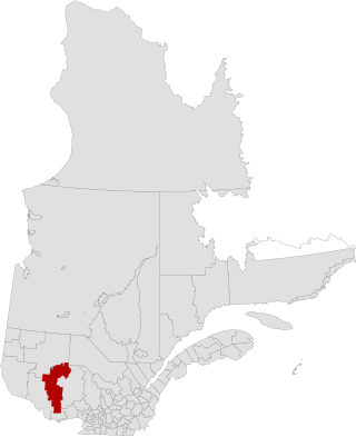
La Vallée-de-la-Gatineau is a regional county municipality in the Outaouais region of western Quebec, Canada. The seat is in Gracefield. It was incorporated on January 1, 1983 and was named for its location straddling the Gatineau River north of Low.
Route 2 is a major provincial highway in the Canadian province of New Brunswick, carrying the main route of the Trans-Canada Highway in the province. The highway connects with Autoroute 85 at the border with Quebec and Highway 104 at the border with Nova Scotia, as well as with traffic from Interstate 95 in the U.S. state of Maine via the short Route 95 connector. A core route in the National Highway System, Route 2 is a four-lane freeway in its entirety, and directly serves the cities of Edmundston, Fredericton, and Moncton.

A concurrency in a road network is an instance of one physical roadway bearing two or more different route numbers. When two roadways share the same right-of-way, it is sometimes called a common section or commons. Other terminology for a concurrency includes overlap, coincidence, duplex, triplex, multiplex, dual routing or triple routing.
Autoroute 20 is a Quebec Autoroute, following the Saint Lawrence River through one of the more densely populated parts of Canada, with its central section forming the main route of the Trans-Canada Highway from the A-25 interchange to the A-85 interchange. At 585 km (363.5 mi), it is the longest Autoroute in Quebec. It is one of two main links between Montreal and Quebec City; the other is the A-40.
Autoroute 40, officially known as Autoroute Félix-Leclerc outside Montreal and Metropolitan Autoroute/Autoroute Métropolitaine within Montreal, is an Autoroute on the north shore of the St. Lawrence River in the Canadian province of Quebec. It is one of the two major connections between Montreal and Quebec City, the other being Autoroute 20 on the south shore of the St. Lawrence. Autoroute 40 is currently 347 km (215.6 mi) long. Between the Ontario–Quebec boundary and the interchange with Autoroute 25, the route is signed as part of the Trans-Canada Highway.
Autoroute 15 is a highway in western Quebec, Canada. It was, until the extension of Autoroute 25 was opened in 2011, the only constructed north-south autoroute to go out of Montreal on both sides. A-15 begins at the end of Interstate 87 at the United States border at Saint-Bernard-de-Lacolle and extends via Montreal to Sainte-Agathe-des-Monts with an eventual continuation beyond Mont-Tremblant. The total length of A-15 is currently 164 km (101.9 mi), including a short concurrency with Autoroute 40 that connects the two main sections. This is one of the few autoroutes in Quebec that does not have any spinoff highways.
Autoroute 25 is an Autoroute in the Lanaudière region of Quebec. It is currently 49 km (30.4 mi) long and services the direct north of Montreal's Metropolitan Area. A-25 has one toll bridge, which is the first modern toll in the Montreal area and one of two overall in Quebec.
Autoroute 50 is an Autoroute in western Quebec, Canada. It links Canada's National Capital Region (Gatineau) and the Greater Montreal area (Mirabel).

Route 132 is the longest highway in Quebec. It follows the south shore of the Saint Lawrence River from the border with the state of New York in the hamlet of Dundee, west of Montreal to the Gulf of Saint Lawrence and circles the Gaspé Peninsula. This highway is known as the Navigator's Route. It passes through the Montérégie, Centre-du-Québec, Chaudière-Appalaches, Bas-Saint-Laurent and Gaspésie regions of the province.
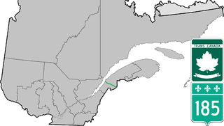
Route 185 is part of the Trans-Canada Highway. It travels from Saint-Antonin to Saint-Louis-du-Ha! Ha!, a distance of about 28 km (17.4 mi). It connects the 2 sections of Autoroute 85 and is the former designation for all of A-85.
Autoroute 10 (A-10) is an Autoroute of Quebec in Canada that links greater Montreal to key population centres in Montérégie and Estrie, including Brossard, Saint-Jean-sur-Richelieu, Granby, and Sherbrooke.
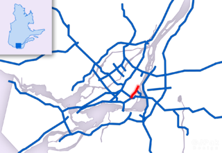
Route 136 (R-136), formerly Autoroute 720, known as the Ville-Marie Expressway (English) or Autoroute Ville-Marie (French) is an Autoroute highway in the Canadian province of Quebec that is a spur route of Autoroute 20 in Montreal. Its western terminus is located at the Turcot Interchange, a junction with Autoroute 15 and Autoroute 20, and its eastern terminus is near the Jacques Cartier Bridge, where the highway merges with Notre-Dame Street. The Autoroute Ville-Marie designation is named after the downtown borough of Ville-Marie, through which the expressway is routed. It was designated Autoroute 720 until 2021 when it was renamed to Route 136.
Autoroute 30 (A-30), or the Autoroute de l'Acier is an Autoroute in Quebec, Canada. Construction of the A-30 dates back to the early days of autoroute construction in the 1960s. Originally called Highway 3, the A-30 was designed to replace Route 132 as the main artery linking the communities along the South Shore of the St. Lawrence River. The A-30 was originally intended to begin at the U.S. border near Dundee and end at Saint-Pierre-les-Becquets. In the late 1970s an eight-year moratorium on new autoroute construction in favour of public transport by the Parti Québécois prevented implementation of that plan.
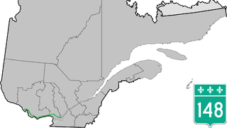
Route 148 is an east-west highway in Quebec, Canada. It runs from junction of Autoroute 13 and Autoroute 440 in Laval in the Montreal region to the Ontario-Quebec border in L'Isle-aux-Allumettes in western Quebec. For most of its length, Route 148 follows the north shore of the Ottawa River where it acted as the principal route between communities in the Outaouais region until the completion of Autoroute 50 in 2012. At the Ontario-Quebec border in L'Isle-aux-Allumettes Route 148 continues into Ontario as Highway 148.

Route 117, the Trans Canada Highway Northern Route, is a provincial highway within the Canadian province of Quebec, running between Montreal and the Quebec/Ontario border where it continues as Highway 66 east of McGarry, Ontario. It is an important road since it is the only direct route between southern Quebec and the Abitibi-Témiscamingue region.
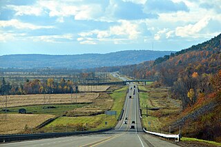
Autoroute 85 is a Quebec Autoroute and the route of the Trans-Canada Highway in the province's Bas-Saint-Laurent region, also known as Autoroute Claude-Béchard. It is currently under construction with committed Federal and Provincial funding for its completion, with an estimated completion date of 2026. Once this upgrade is completed, it will close the last gap in the nearly continuous freeway section of the Trans-Canada between Arnprior, Ontario, and Antigonish, Nova Scotia, and for an even longer interprovincial freeway route between Windsor, Ontario and Halifax, Nova Scotia. Running between Rivière-du-Loup and a junction with New Brunswick Route 2 at the Quebec-New Brunswick border, A-85 when complete will be the only controlled access highway link between the Maritime Provinces and the rest of the country. A-85 is projected to be approximately 100 km (60 mi) long when construction is complete and is intended to replace Route 185, which has been called one of the deadliest highways in Canada.

The réseau routier québécois is managed by the Quebec Ministry of Transportation and consists of about 185,000 kilometres (115,000 mi) of highways and roads. In addition, Quebec has almost 12,000 bridges, tunnels, retaining walls, culverts, and other structures such as the Quebec Bridge, the Pierre Laporte Bridge, the Laviolette Bridge and the Louis-Hippolyte Lafontaine Bridge–Tunnel.


