Quebec Route 117

Last updated

Qc117.svg Trans-Canada Highway Quebec.svg

Route 117

Route Transcanadienne
Route 117-QC.png
Route information
Maintained by Transports Québec
Length663.9 km [1]  (412.5 mi)
HistoryQC-11 (1952).svg Route 11 (LavalGrand-Remous)
QC-11A (1952).svg Route 11A (MontrealLaval)
QC-58 (1952).svg Route 58 (Grand-RemousLouvicourt)
QC-59 (1952).svg Route 59 (LouvicourtOntario border)
Major junctions
South endQuebec Autoroute 15.svgQuebec Autoroute 40.svgTrans-Canada Highway shield.svg A-15  / A-40 (TCH) in Montreal
Major intersectionsQuebec Autoroute 440.svg A-440 in Laval
Quebec Autoroute 15.svgTrans-Canada Highway shield.svg A-15 (TCH) in Laval
Quebec Autoroute 640.svg A-640 in Rosemère
Quebec Autoroute 50.svg A-50 in Mirabel
Qc158.svg R-158 in Saint-Jérôme
Quebec Autoroute 15.svgTrans-Canada Highway shield.svg A-15 (TCH) in Sainte-Adèle
Quebec Autoroute 15.svgTrans-Canada Highway shield.svg A-15 (TCH) in Val-Morin
Quebec Autoroute 15.svgTrans-Canada Highway shield.svg A-15 (TCH) in Sainte-Agathe-des-Monts
Qc107.svg R-107 in Mont-Laurier
Qc105.svg R-105 in Grand-Remous
Qc111.svgQc113.svg R-111  / R-113 in Val-d'Or
Qc109.svg R-109 in Rivière-Héva
Qc101.svg R-101 in Rouyn-Noranda
North endOntario 66.svgTrans-Canada Highway shield.svg Highway 66  / TCH near McGarry, ON
Location
Country Canada
Province Quebec
Highway system
Qc116.svg R-116 Qc122.svg R-122
Route 117 at La Conception Route 117.jpg
Route 117 at La Conception

Route 117, the Trans Canada Highway Northern Route, is a provincial highway within the Canadian province of Quebec, running between Montreal and the Quebec/Ontario border where it continues as Highway 66 east of McGarry, Ontario. It is an important road since it is the only direct route between southern Quebec and the Abitibi-Témiscamingue region.

Contents

Route 117 was formerly Route 11 and ran from Montreal north towards Mont-Laurier and then followed the Gatineau River south towards Gatineau. This routing is joined with Autoroute 15 from Montreal northwards towards Mont Tremblant. Route 117 also takes in the former Quebec Routes 58 and 59.

Along with Autoroute 15 to Sainte-Agathe-des-Monts, it is also listed as a branch of the Trans-Canada Highway. Ontario Highway 17 is also a branch of the Trans-Canada Highway but is an unrelated route that parallels it by about 200 km (120 mi).

Route description

This description of Route 117 follows it from southeast to northwest.

Route 117 starts in Montreal at the Décarie Interchange where Autoroute 40 and Autoroute 15 (Décarie Expressway) meet. Montrealers sometimes unofficially extend Route 117 along the portion of Décarie Boulevard that runs parallel to the Décarie Expressway.

117 Fin/End sign at the end of Marcel Laurin Blvd. in Montreal, Quebec 117 Fin 2.jpg
117 Fin/End sign at the end of Marcel Laurin Blvd. in Montreal, Quebec

From the Décarie Interchange, Route 117 goes north on Marcel-Laurin Boulevard to Keller Boulevard. It continues from Laurentian Boulevard to Keller Boulevard, southbound only, or on Lachapelle Street from Keller Boulevard, northbound only, and crosses the Rivière des Prairies over the Lachapelle Bridge to Île Jésus. It continues through the Laval neighborhoods of Chomedey, Fabreville and Sainte-Rose, northbound as Boulevard Curé-Labelle, Boulevard Chomedey at the former Chenoy's deli, left turn at Boulevard Cartier and back into Boulevard Curé-Labelle, southbound as Boulevard Curé-Labelle.

At the Rivière des Mille Îles, it crosses over the Marius Dufresne Bridge to the "North Shore" (of the Rivière des Mille Îles). Then, Route 117 runs parallel to Autoroute 15 until Sainte-Agathe-des-Monts and goes through the Laurentian mountains. Towns along the route in this section include:

After Sainte-Agathe-des-Monts, Route 117 continues as a four-lane divided highway and winds its way through Laurentides Regional County Municipality until it reaches the town of Labelle. From then on to the Ontario border, Route 117 is mostly a standard two-lane highway. In Grand-Remous, Route 117 crosses the Gatineau River and intersects with Route 105, which goes southwest to Maniwaki and Gatineau. Towns along the route in this section include:

Highway 117 at the Dozois Reservoir Reservoir Dozois.JPG
Highway 117 at the Dozois Reservoir

From Grand-Remous, the route heads north for some 220 km (140 mi) through undeveloped wilderness, most of which is part of La Vérendrye Wildlife Reserve. While the reserve is popular for a variety of outdoor activities, services along the road are sparse. This section is often considered one of the most dangerous routes in the province because of numerous fatal accidents, some involving tractor-trailers. During the winter, the route is often extremely slippery, even during dry and clear days. The few communities along this section are:

After the intersection with Route 113, which continues north to Lebel-sur-Quévillon, Route 117 heads west to Ontario where it becomes Highway 66. The section between Rouyn-Noranda and Arntfield runs concurrent with Route 101. Towns along the route in this section include:

In other media

The rivalry in the Quebec Maritimes Junior Hockey League between the Val-d'Or Foreurs and the Rouyn-Noranda Huskies, the only two QMJHL teams in the Abitibi-Témiscamingue region, is known as La Guerre de la 117 (French for "The War of the 117") due to both teams' home cities, Val-d'Or and Rouyn-Noranda, being located along Route 117. [2] [3]

Major intersections

RCMLocationkm [1] miExitDestinationsNotes
Montréal Montréal 0.00.0Quebec Autoroute 15.svgQuebec Autoroute 40.svgTrans-Canada Highway shield.svgQuebec Autoroute 520.svgQuebec I-300-1.svg A-15 (Autoroute Décarie) / A-40 (TCH) (Autoroute Félix-Leclerc / Autoroute Métropolitaine) to A-520  P.-E.-Trudeau International Airport, Ottawa/Gatineau, Laval, Quebec Décarie Interchange
A-15 exit 70; A-40 exit 66; R-117 follows Boulevard Marcel-Laurin
Boulevard Décarie Northbound exit and southbound entrance
2.01.2 Boulevard Côte-Vertu
4.12.5 Boulevard Henri Bourassa Becomes Boulevard Laurentien north of intersection
4.62.9Boulevard KellerSouth end of one-way pair; northbound follows Rue Lachapelle; southbound follows Boulevard Laurentien
5.63.5 Boulevard Gouin
5.93.7One way transitionNorth end of one-way pair
Rivière des Prairies 6.0–
6.3
3.7–
3.9
Pont Lachapelle (Lachapelle Bridge)
Laval 7.04.3Chomedey Boulevard / Cartier Boulevard
9.86.1Boulevard Saint-MartinFormer R-148
11.77.3Quebec Autoroute 440.svg A-440 (Autoroute Jean-Noël-Lavoie)A-440 exit 19
14.59.0Quebec Autoroute 15.svgTrans-Canada Highway shield.svg A-15 (TCH) (Autoroute des Laurentides) Saint-Jérôme, Montréal A-15 exit 14
Rivière des Mille Îles 17.6–
18.1
10.9–
11.2
Pont Marius-Dufresne (Marius Dufresne Bridge)
Thérèse-De Blainville Rosemère 19.111.9Qc344.svg R-344 (Chemin de la Grande-Côte)
RosemèreSainte-Thérèse boundary20.812.9Quebec Autoroute 640.svg A-640  Repentigny, Saint-Eustache A-640 exit 22
Mirabel 35.622.1Quebec Autoroute 50.svgQuebec Autoroute 15.svgQuebec I-300-1.svg A-50 west to A-15  Mirabel International Airport, Lachute, Gatineau A-50 eastern terminus; at-grade
La Rivière-du-Nord Saint-Jérôme 40.525.2Qc158.svgQuebec Autoroute 15.svg R-158 (Boulevard Lachapelle) to A-15
46.028.6Qc333.svg R-333 north (Boulevard des Hauteurs) Saint-Hippolyte R-333 southern terminus
46.528.946Quebec Autoroute 15.svg To A-15  Montreal Interchange; R-117 south uses exit 46
Les Pays-d'en-Haut Sainte-Anne-des-Lacs 57.936.0Quebec Autoroute 15.svg To A-15  / Chemin de Sainte-Anne-des-Lacs Sainte-Anne-des-Lacs A-15 exit 57
Sainte-Adèle 63.839.6Quebec Autoroute 15.svg To A-15  / Chemin du Mont-GabrielA-15 exit 64
65.9–
66.8
40.9–
41.5
Quebec Autoroute 15.svgTrans-Canada Highway shield.svg A-15 (TCH) south Montreal Northbound entrance and southbound exit; northbound exit and southbound entrance from A-15; A-15 exit 67
68.242.4Qc370.svgQuebec Autoroute 15.svg R-370 east (Chemin Pierre-Péladeau) to A-15 north / Rue MorinR-370 western terminus
70.143.6Quebec Autoroute 15.svgTrans-Canada Highway shield.svg A-15 (TCH) south Montreal Entrance only to A-15 south
Les Laurentides Val-Morin 75.546.9Quebec Autoroute 15.svgTrans-Canada Highway shield.svg A-15 (TCH) south Montreal No northbound exit; northbound exit and southbound entrance from A-15; A-15 exit 76
Sainte-Agathe-des-Monts 85.1–
85.3
52.9–
53.0
Quebec Autoroute 15.svgTrans-Canada Highway shield.svg A-15 (TCH)  / Chemin de la Montagne / Chemin de la Rivière Montreal, Mont Tremblant A-15 exit 86
86.253.6Qc329.svg R-329 south (Rue Principale) / Rue Desjardins / Rue Raymond – Centre-Ville, Saint-Adolphe-d'Howard Roundabout; south end of R-329 concurrency
88.3–
88.9
54.9–
55.2
89Quebec Autoroute 15.svgTrans-Canada Highway shield.svgQc329.svg A-15 (TCH) south / R-329 north Saint-Donat, Sainte-Adèle, Montreal A-15 northern terminus; north end of R-329 concurrency; south end of Trans-Canada Highway; R-117 south uses exit 89
Mont-Blanc 107.166.5107Rue PrincipaleInterchange
Mont-Tremblant 113.670.6Rue Siméon – Centre-VilleRoundabout
114.771.3Rue Vaillancourt – Centre-VilleRoundabout
116.372.3116Qc327.svg R-327 (Rue Léonard) Huberdeau, Lachute Interchange
117.1–
117.9
72.8–
73.3
117Qc323.svg R-323 south (Chemin de Brébeuf) Montebello, Brébeuf Interchange; R-323 northern terminus
130.0–
131.1
80.8–
81.5
119Montée RyanInterchange
La Conception 126.378.5126Route des TulipesInterchange
Labelle 139.786.8140Boulevard du Curé-LabelleInterchange
142.488.5143Chemin Augustin-LauzonInterchange
144.890.0145Boulevard du Curé-LabelleNorthbound exit and entrance
146.090.7Chemin de La Minerve / Boulevard du Curé-LabelleRoundabout under construction
Antoine-Labelle Rivière-Rouge 160.099.4Chemin Deslauriers / Rue L'Annonciation SudRoundabout
162.1100.7162Quebec I-300-1.svg La Macaza – Mont Tremblant International Airport, Rivière-Rouge Centre-Ville, La Macaza Interchange
162.1100.7Qc321.svg R-321  Nominingue, L'Ascension Roundabout
Lac-des-Écorces 209.8130.4Qc311.svg R-311 north Chute-Saint-Philippe, Mont-Saint-Michel South end of R-311 concurrency
210.2130.6Qc311.svg R-311 south Val-Barrette, Kiamika North end of R-311 concurrency
Mont-Laurier 222.9138.5Qc309.svg R-309  Gatineau, Ferme-Neuve
240.0149.1Qc107.svg R-107 south Aumond R-107 northern terminus
La Vallée-de-la-Gatineau Grand-Remous 257.3159.9Qc105.svg R-105 south Maniwaki, Gatineau R-105 northern terminus
La Vallée-de-l'Or Val-d'Or 429.8267.1Qc113.svg R-113 north Senneterre, Lebel-sur-Quévillon R-113 southern terminus
508.3315.83e Avenue / Rue Saint-Jacques – Centre-VilleRoundabout
510.7317.3Qc397.svg R-397 north (Boulevard Jean-Jacques-Cossette) – Centre-Ville, Barraute Roundabout; R-397 southern terminus
511.7318.0Rue de l'HydroRoundabout
513.6319.1Qc111.svg R-111 north / Chemin Sullivan Terrebonne Roundabout; R-111 southern terminus
516.5320.93e Avenue / Boulevard BarretteRoundabout
Malartic 540.3335.7Rue de l'Accueil / Chemin du Camping-RégionalRoundabout
Rivière-Héva 555.4345.1Qc109.svg R-109 north Amos R-109 southern terminus
Rouyn-Noranda 572.5355.7Qc395.svg R-395 north Preissac R-395 southern terminus
614.5381.8Avenue Larivière Rouyn-Noranda Centre-VilleRoundabout; former R-117 alignment
622.1386.6Qc101.svg R-101 north D'Alembert, D'Alembert Roundabout; south end of R-101 concurrency
625.6388.7Boulevard Rideaux – Rouyn-Noranda Centre-VilleFormer R-117 alignment
627.2389.7Avenue Davy / Rue ManthaRoundabout
644.5400.5Qc101.svg R-101 south Ville-Marie North end of R-101 concurrency
663.9412.5Ontario 66.svgTrans-Canada Highway shield.svg Highway 66 west / TCH  Kirkland Lake Continuation into Ontario
1.000 mi = 1.609 km; 1.000 km = 0.621 mi

See also

Related Research Articles

<span class="mw-page-title-main">Laval, Quebec</span> City in Quebec, Canada

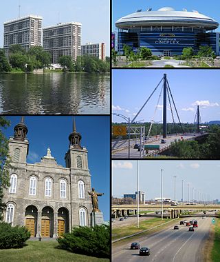
Laval is a city in Quebec, Canada. It is in the southwest of the province, north of Montreal. It is the largest suburb of Montreal, the third-largest city in the province after Montreal and Quebec City, and the thirteenth largest city in Canada, with a population of 443,192 in 2021.

<span class="mw-page-title-main">Autoroutes of Quebec</span> Highway system in Quebec, Canada

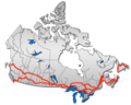
The Quebec Autoroute System or le système d'autoroute au Québec is a network of freeways within the province of Quebec, Canada, operating under the same principle of controlled access as the Interstate Highway System in the United States and the 400-series highways in neighbouring Ontario. The Autoroutes are the backbone of Quebec's highway system, spanning almost 2,400 km (1,491 mi). The speed limit on the Autoroutes is generally 100 km/h (62 mph) in rural areas and 70–90 km/h (43–56 mph) in urban areas; most roads are made of asphalt concrete.

<span class="mw-page-title-main">Rouyn-Noranda</span> City in Quebec, Canada

Rouyn-Noranda is a city on Osisko Lake in the Abitibi-Témiscamingue region of Quebec, Canada.

<span class="mw-page-title-main">Abitibi-Témiscamingue</span> Administrative region in Quebec, Canada

Abitibi-Témiscamingue is an administrative region located in western Québec, Canada, along the border with Ontario. It became part of the province in 1898. It has a land area of 57,736.50 square kilometres (22,292.19 sq mi) and its population was 147,082 people as of the 2021 census. The region is divided into five regional county municipalities and 79 municipalities. Its economy continues to be dominated by resource extraction industries. These include logging and mining all along the rich geologic Cadillac Fault between Val-d'Or and Rouyn-Noranda, as well as agriculture.

Area codes 819, 873, and 468 are overlay telephone area codes in the North American Numbering Plan (NANP) for central and western Quebec, Canada, including the Quebec portion of the National Capital Region, and the Hudson Strait and Ungava Bay coastlines of Quebec. Major cities in the territory include Gatineau, Sherbrooke, Trois-Rivières, Drummondville, Shawinigan, Victoriaville, Rouyn-Noranda, Val-d'Or, Magog and Mont-Laurier.

<span class="mw-page-title-main">Val-d'Or Foreurs</span> Junior ice hockey team in Val-dOr, Quebec

The Val-d'Or Foreurs are a Canadian junior ice hockey team based in Val-d'Or, in the region of Abitibi-Témiscamingue, Quebec. The team was founded for the 1993–94 season of the Quebec Maritimes Junior Hockey League, a member of the Canadian Hockey League. Former Quebec Nordiques and Trois-Rivières Draveurs star, Pierre Aubry was the team's first coach. The literal translation of Val-d'Or Foreurs is "Valley of Gold Drillers"; this name references the drilling operations associated with mining and exploration which are a major source of blue-collar work in the area. The Foreurs play their home games in the Centre Agnico Eagle.

The 2000–2006 municipal reorganization in Quebec resulted in large-scale amalgamation of smaller municipalities in Quebec into larger cities. It was undertaken by one administration, but was modified and partially undone by its successor.

Autoroute 20 is a Quebec Autoroute, following the Saint Lawrence River through one of the more densely populated parts of Canada, with its central section forming the main route of the Trans-Canada Highway from the A-25 interchange to the A-85 interchange. At 585 km (363.5 mi), it is the longest Autoroute in Quebec. It is one of two main links between Montreal and Quebec City; the other is the A-40.

Autoroute 15 is a highway in western Quebec, Canada. It was, until the extension of Autoroute 25 was opened in 2011, the only constructed north-south autoroute to go out of Montreal on both sides. A-15 begins at the end of Interstate 87 at the United States border at Saint-Bernard-de-Lacolle and extends via Montreal to Sainte-Agathe-des-Monts with an eventual continuation beyond Mont-Tremblant. The total length of A-15 is currently 164 km (101.9 mi), including a short concurrency with Autoroute 40 that connects the two main sections. This is one of the few autoroutes in Quebec that does not have any spinoff highways.

<span class="mw-page-title-main">Boulevard Saint-Joseph</span>

Boulevard Saint-Joseph is a commercial boulevard in the former city of Hull, Quebec. It runs from Boulevard Alexandre-Taché to the boundaries of the Gatineau and the suburban town of Chelsea.

<span class="mw-page-title-main">Quebec Route 148</span> Highway in Quebec

Route 148 is an east-west highway in Quebec, Canada. It runs from junction of Autoroute 13 and Autoroute 440 in Laval in the Montreal region to the Ontario-Quebec border in L'Isle-aux-Allumettes in western Quebec. For most of its length, Route 148 follows the north shore of the Ottawa River where it acted as the principal route between communities in the Outaouais region until the completion of Autoroute 50 in 2012. At the Ontario-Quebec border in L'Isle-aux-Allumettes Route 148 continues into Ontario as Highway 148.

<span class="mw-page-title-main">Quebec Route 105</span> Highway in Quebec

Route 105 is a north-south highway in Quebec, Canada. It runs from Hull, where it is known as Boulevard Saint-Joseph, to Grand-Remous where it ends at Route 117.

<span class="mw-page-title-main">Quebec Route 366</span> Highway in Quebec

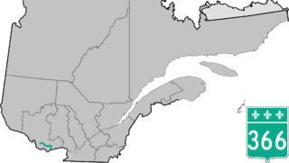
Route 366 is a secondary highway in the Outaouais region of Quebec. It runs from Route 301 near Creemorne in the Pontiac to Route 148 in the city of Gatineau.

<span class="mw-page-title-main">Quebec Route 307</span> Highway in Quebec

Route 307 is a provincial road located in the Outaouais region of Quebec. The road runs mostly parallel to the Gatineau River on the eastern side of it. It starts at the corner of Rue Saint-Louis and Boulevard Greber in the Gatineau sector of the city of Gatineau. It runs north of Gatineau and ends in Val-des-Bois at the junction of Route 309 which runs from the Buckingham sector north into the Upper Laurentians.

Montreal Area Control Centre is one of 7 Area Control Centres in Canada operated by Nav Canada. Montreal ACC is located in a building on the outskirts of Montréal–Pierre Elliott Trudeau International Airport.

The 2015–16 QMJHL season is the 47th season of the Quebec Major Junior Hockey League (QMJHL). The regular season began on September 10, 2015, and ended on March 19, 2016.

Sainte Agathe Academy is a public anglophone primary and secondary school in Sainte-Agathe-des-Monts, Quebec. It is operated by the Sir Wilfrid Laurier School Board.

References

  1. 1 2 Google (March 10, 2023). "Route 117 in Quebec" (Map). Google Maps . Google. Retrieved March 10, 2023.
  2. "Les Huskies rejoignent les Foreurs dans la guerre de la 117". www.lecitoyenvaldoramos.com (in French). Retrieved 2024-05-04.
  3. Pratt, Alexandre (2021-10-10). "Foreurs — Huskies: La guerre de la 117". La Presse (in Canadian French). Retrieved 2024-05-04.
Template:Attached KML/Quebec Route 117
KML is from Wikidata
Preceded by Trans-Canada Highway
Qc117.svg Route 117
Succeeded by