Westmount is an affluent municipality on the Island of Montreal, in southwestern Quebec, Canada. It is an enclave of the city of Montreal, with a population of 19,658 as of the 2021 Canadian census.

Notre-Dame-de-Grâce, also nicknamed NDG, is a residential neighbourhood of Montreal in the city's West End, with a population of 166,520 (2016). An independent municipality until annexed by the City of Montreal in 1910, NDG is today one half of the borough of Côte-des-Neiges–Notre-Dame-de-Grâce. It comprises two wards, Loyola to the west and Notre-Dame-de-Grâce to the east. NDG is bordered by four independent enclaves; its eastern border is shared with the City of Westmount, Quebec, to the north and west it is bordered by the cities of Montreal West, Hampstead and Côte-Saint-Luc. NDG plays a pivotal role in serving as the commercial and cultural hub for Montreal's predominantly English-speaking West End, with Sherbrooke Street West running the length of the community as the main commercial artery. The community is roughly bounded by Claremont Avenue to the east, Côte-Saint-Luc Road to the north, Brock Avenue in the west, and Highway 20 and the Saint-Jacques Escarpment to the south.
The architecture of Montreal, Quebec, Canada is characterized by the juxtaposition of the old and the new and a wide variety of architectural styles, the legacy of two successive colonizations by the French, the British, and the close presence of modern architecture to the south. Much like Quebec City, the city of Montreal had fortifications, but they were destroyed between 1804 and 1817.
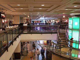
RÉSO, commonly referred to as the Underground City, is the name applied to a series of interconnected office towers, hotels, shopping centres, residential and commercial complexes, convention halls, universities and performing arts venues that form the heart of Montreal's central business district, colloquially referred to as Downtown Montreal. The name refers to the underground connections between the buildings that compose the network, in addition to the network's complete integration with the city's entirely underground rapid transit system, the Montreal Metro. Moreover, the first iteration of the Underground City was developed out of the open pit at the southern entrance to the Mount Royal Tunnel, where Place Ville Marie and Central Station stand today.

The Green Line, also known as Line 1, is one of the four lines of the Montreal Metro in Montreal, Quebec, Canada. The line runs through the commercial section of downtown Montreal underneath Boulevard de Maisonneuve, formerly Rue de Montigny. It runs mainly on a northeast to southwest axis with a connection to the Orange and Yellow Lines at Berri-UQAM, and with the Orange Line west of downtown at Lionel-Groulx.

Berri–UQAM station is a Montreal Metro station in the borough of Ville-Marie, in Montreal, Quebec, Canada. It is operated by the Société de transport de Montréal (STM) and is the system's central station. This station is served by the Green, Orange, and Yellow lines. It is located in the Quartier Latin.

Atwater station is a Montreal Metro station in the borough of Ville-Marie in Montreal, Quebec, Canada. It is operated by the Société de transport de Montréal (STM) and serves the Green Line on the border between the city of Westmount and Montreal.

Guy–Concordia station is a Montreal Metro station in the borough of Ville-Marie in Montreal, Quebec, Canada. It is operated by the Société de transport de Montréal (STM) and serves the Green Line. The station opened on October 14, 1966, as part of the original network of the Metro. It has consistently been one of the network's busiest stations, ranking 5th from 2000 to 2001, 4th from 2002 to 2007, 3rd since 2008, and 2nd since 2021.

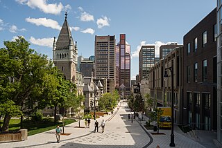
Ville-Marie is the name of a borough (arrondissement) in the centre of Montreal, Quebec. The borough is named after Fort Ville-Marie, the French settlement that would later become Montreal, which was located within the present-day borough. Old Montreal is a National Historic Site of Canada.
The Quartier international de Montréal (QIM) or Montreal's International District is a district of the Ville-Marie borough in the city's downtown core of Montreal, Quebec, Canada. It is roughly bordered by René-Levesque Boulevard to the north, Notre-Dame Street to the south, De Bleury/Saint-Pierre Street to the east and Robert-Bourassa Boulevard to the west. The Palais des congrès building lying just east of the district is also usually comprised in it. Constructed dispersedly between 1965 and 1985 in place of older colonial housing blocks, the district underwent major urban renewal as a central business district in 2000–2003.

Sainte-Catherine Street is the primary commercial artery of Downtown Montreal, Quebec, Canada. It crosses the central business district from west to east, beginning at the corner of Claremont Avenue and de Maisonneuve Boulevard in Westmount, and ending at the Grace Dart Extended Care Centre by Assomption metro station, where it folds back into Notre-Dame Street. It also traverses Ville-Marie, passing just east of Viau in Mercier–Hochelaga-Maisonneuve. The street is 11.2 km long, and considered the backbone of Downtown Montreal.

Montreal East is an on-island suburb in southwestern Quebec, Canada, on the island of Montreal. Montreal-Est has been home to many large oil refineries since 1915.
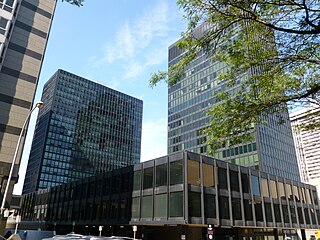
Westmount Square is a residential and office complex located in Westmount, Quebec, Canada. There are two residential apartment buildings and two office buildings. These towers sit atop an underground shopping centre consisting of thirty-five shops. It is located between Saint Catherine Street and De Maisonneuve Boulevard and between Wood Avenue and Greene Avenue. It is connected to Place Alexis Nihon, Dawson College, and the Atwater Metro station by a tunnel.

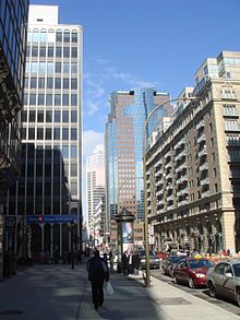
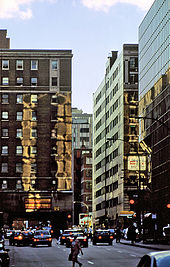
Downtown Montreal is the central business district of Montreal, Quebec, Canada.

Alexis Nihon Complex is a 223,000 m2 (2,400,000 sq ft) building complexe situated at the border of Downtown Montreal, Quebec, Canada and the neighbouring city of Westmount, consisting of a shopping mall, two office towers, and a residential building. Although the complex is typically associated with Downtown Montreal and its main entrance on Atwater Avenue is in Montreal proper, more than 80% of the land it occupies is located in Westmount. It is named after the inventor and businessman Alexis Nihon. The shopping mall is directly connected to the Atwater metro station, which joins the building by a short tunnel with the adjacent Dawson College, and by a longer one adjoins nearby Westmount Square. The original complex was designed by the Montreal architect Harold Ship, and its architectural plans are housed at the Canadian Centre for Architecture.

Sherbrooke Street is a major east–west artery and at 31.3 kilometres (19.4 mi) in length, is the second longest street on the Island of Montreal, Canada. The street begins in the town of Montreal West and ends on the extreme tip of the island in Pointe-aux-Trembles, intersecting Gouin Boulevard and joining up with Notre-Dame Street. East of Cavendish Boulevard this road is part of Quebec Route 138.

Atwater Avenue is a major north–south street located in Montreal, Quebec, Canada. It links Doctor Penfield Avenue in the Ville-Marie borough to the north, and Henri Duhamel Street in the Verdun borough to the south. It is named for Edwin Atwater. The street runs through the Atwater Tunnel near the Atwater Market in Saint-Henri, before climbing and straddling the border of the city of Westmount.

Saint Antoine Street, formerly known as Craig Street, is a street located in Montreal, Quebec, Canada. It runs to the south of Downtown Montreal and north of Old Montreal and Griffintown and Saint-Henri. It crosses the Quartier international de Montréal. Between Atwater Avenue and Greene Avenue, the north side of the street is in Westmount.

Shaughnessy Village is a neighbourhood of Montreal, Quebec, Canada, located on the western side of the Ville-Marie borough. It is bounded by Guy Street to the east, Atwater Street to the west, Sherbrooke Street to the north, and René Lévesque Boulevard and the Ville-Marie Expressway to the south.
Montreal has a developed transport infrastructure network, which includes well-developed air, road, rail, and maritime links to the rest of Canada, as well as the United States and the rest of the world. Local public transport includes a metro system, buses, ferry services and cycling infrastructure.