
Hoover Dam is a concrete arch-gravity dam in the Black Canyon of the Colorado River, on the border between the U.S. states of Nevada and Arizona. It was constructed between 1931 and 1936 during the Great Depression and was dedicated on September 30, 1935, by President Franklin D. Roosevelt. Its construction was the result of a massive effort involving thousands of workers, and cost over one hundred lives. Originally known as Boulder Dam from 1933, it was officially renamed Hoover Dam for President Herbert Hoover by a joint resolution of Congress in 1947.

The Taum Sauk pumped storage plant is a power station in the St. Francois mountain region of Missouri, United States about 90 miles (140 km) south of St. Louis near Lesterville, Missouri, in Reynolds County. It is operated by Ameren Missouri.

Jennings Randolph Lake is a reservoir of 952 acres (3.85 km2) located on the North Branch Potomac River in Garrett County, Maryland and Mineral County, West Virginia. It is approximately eight miles upstream of Bloomington, Maryland, and approximately five miles north of Elk Garden, West Virginia.

Tarbela Dam is an earth-filled dam along the Indus River in Pakistan’s Khyber Pakhtunkhwa province. Located in the Haripur mainly and in some area of Swabi of the province, the dam is about 30 km (20 mi) from the city of Swabi, 105 km (65 mi) northwest of Islamabad, and 125 km (80 mi) east of Peshawar. It is the largest earth-filled dam in the world, and also the largest dam by structural volume.

The Bull Run Hydroelectric Project was a Portland General Electric (PGE) development in the Sandy River basin in the U.S. state of Oregon. Originally built between 1908 and 1912 near the town of Bull Run, it supplied hydroelectric power for the Portland area for nearly a century, until it was removed in 2007 and 2008. The project used a system of canals, tunnels, wood box flumes and diversion dams to feed a remote storage reservoir and powerhouse. The entire project was removed because of rising environmental costs. Marmot Dam on the Sandy River was demolished in 2007, and the Little Sandy Dam on the Little Sandy River was taken down in 2008.

The Idukki Dam is a double curvature Arch dam constructed across the Periyar River in a narrow gorge between two granite hills locally known as Kuravan and Kurathi in Kerala, India. At 168.91 metres (554.2 ft), it is one of the highest arch dams in Asia. It is constructed and owned by the Kerala State Electricity Board. It supports a 780 MW hydroelectric power station in Moolamattom, which started generating power on 4 October 1975. The dam type is a concrete, double curvature parabolic, thin arc dam.

Copeton Dam is a major clay core and rock fill embankment dam with nine radial gates and a gated concrete chute spillway across the Gwydir River upstream of Bingara in the New England region of New South Wales, Australia. The dam's purpose includes environmental flows, hydro-electric power generation, irrigation, and water supply. The impounded reservoir is called Lake Copeton.
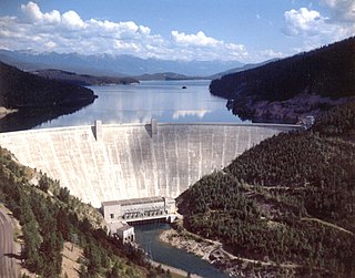
Hungry Horse Dam is an arch dam in the western United States, on the South Fork Flathead River in the Rocky Mountains of northwest Montana. It is located in Flathead National Forest in Flathead County, about fifteen miles (24 km) south of the west entrance to Glacier National Park, nine miles (14 km) southeast of Columbia Falls, and twenty miles (32 km) northeast of Kalispell. The Hungry Horse project, dam, and powerplant are operated by the U.S. Bureau of Reclamation. The entrance road leading to the dam is located in Hungry Horse.

Lower Baker Dam is a dam across the Baker River one mile north of Concrete, Washington. It forms a reservoir called Lake Shannon which stretches 7.5 miles (12.1 km) upstream. The dam is operated by Puget Sound Energy as part of the Baker River Hydroelectric Project.
Upper Baker Dam is a dam spanning the Baker River in northern Washington in the United States of America. It is one of two dams on the river, the other one being the Lower Baker Dam a few miles downstream. The dam is used to generate hydroelectricity and provide flood control.

Hydropower policy in the United States includes all the laws, rules, regulations, programs and agencies that govern the national hydroelectric industry. Federal policy concerning waterpower developed over considerable time before the advent of electricity, and at times, has changed considerably, as water uses, available scientific technologies and considerations developed to the present day; over this period the priority of different, pre-existing and competing uses for water, flowing water and its energy, as well as for the water itself and competing available sources of energy have changed. Increased population and commercial demands spurred this developmental growth and many of the changes since, and these affect the technology's use today.

The Pensacola Dam, also known as the Grand River Dam, is a multiple-arch buttress dam on the Grand River in-between Disney and Langley in the U.S. state of Oklahoma. The dam is operated by the Grand River Dam Authority and creates Grand Lake o' the Cherokees. After decades of vision and planning, it was constructed between 1938 and 1940 for the purposes of hydroelectric power generation, flood control and recreation. It is Oklahoma's first hydroelectric power plant and is referred to as the longest multiple-arch dam in the world.

Mohmand Dam is an under construction multi-purpose concrete-faced rock-filled dam located on the Swat River and Panjkora River approximately 37 km north of Peshawar and 5 km upstream of Munda Headworks in Mohmand District, Khyber Pakhtunkhwa, Pakistan.

The Big Creek Hydroelectric Project is an extensive hydroelectric power scheme on the upper San Joaquin River system, in the Sierra Nevada of central California. The project is owned and operated by Southern California Edison (SCE). The use and reuse of the waters of the San Joaquin River, its South Fork, and the namesake of the project, Big Creek – over a vertical drop of 6,200 ft (1,900 m) – have over the years inspired a nickname, "The Hardest Working Water in the World".
The Koma Kulshan Project is a 13.3 MW run-of-the-river hydroelectric generation facility on the slopes of Mount Baker, a stratovolcano in Washington state's North Cascades. The project commenced commercial operation in October 1990, and is owned by a Covanta Energy–Atlantic Power joint venture. It supplies Puget Sound Energy via a Power Supply Agreement (PSA) contract. Its single turbine is a Pelton wheel supplied by Sulzer Escher Wyss.

The Cushaw Hydroelectric Project is a 7.5 megawatt (MW) dam and power house facility owned and operated by Virginia Electric Power Company, operating as Dominion Virginia Power.
The Bedford Hydropower Project is a hydroelectric generation facility on the James River near the community of Big Island, Virginia. The project includes a low head structure completely spanning the river; river flow is split into a concrete canal leading to the hydroelectric generation facility and the natural river course.
The Reusens Dam is a 12.5 MW hydroelectric generation facility on the James River near the city of Lynchburg, Virginia. The project includes a concrete gravity dam spanning the left side of river which incorporates eight 16 3/4-foot-high flood gates, a 125 feet long by 25 feet tall concrete arch dam segment with 7 1/4-foot-high flashboards, and two separate power houses towards the right bank which contain hydroelectric generation equipment. The A and B power houses have installed capacities of 7.5 MW with three turbines and 5.0 MW with two turbines, respectively. The plant is used in a peaking capacity. The dam is located downstream of the smaller Holcomb Rock Dam and upstream of the Scotts Mill Dam. The typically submerged Bosher Dam near Richmond lies further downstream.
The Coleman Falls Dam is a hydroelectric generation facility on the James River near the community of Coleman Falls, Virginia. The project includes a gravity dam spanning the left side of river and a power house on the right bank which contain hydroelectric generation equipment.
The Big Island Dam is a hydroelectric generation facility on the James River near the community of Big Island, Virginia. The project includes a gravity dam spanning the left side of river and a power house on the right bank which contain hydroelectric generation equipment. The dam is located adjacent to and integrated with the large Georgia Pacific paper mill at this location.
