Huey P. Long Bridge (Jefferson Parish)

Last updated

Huey P. Long Bridge
Hueylongbridge.jpg
The Huey Long Bridge in 2007, when widening work had just begun.
Coordinates 29°56′39″N90°10′08″W / 29.94417°N 90.16889°W / 29.94417; -90.16889
CarriesUS 90.svg US 90 and New Orleans Public Belt Railroad
Crosses Mississippi River
Locale Jefferson Parish, Louisiana
Maintained by New Orleans Public Belt Railroad
ID number 022600060100001
Characteristics
Design Cantilever truss bridge
Total length8,076 feet (2,462 m) (road)
22,996 feet (7,009 m) (rail)
Longest span790 feet (241 m)
Clearance below 153 feet (47 m)
No. of lanes 6
Rail characteristics
No. of tracks 2
History
Construction cost$13.4 million [1] [2] (equivalent to $234 million in 2023 dollars)
OpenedDecember 1935
(widened June 2013)
Statistics
Daily traffic 43,000 (2008)
18.9 trains per day (as of 2014) [3]
Location
Huey P. Long Bridge (Jefferson Parish)

The Huey P. Long Bridge, [5] located in Jefferson Parish, Louisiana, is a cantilevered steel through-truss bridge that carries a two-track railroad line over the Mississippi River at mile 106.1, with three lanes of US 90 on each side of the central tracks. It is several kilometers upriver from the city of New Orleans. The East Bank entrance is at Elmwood, Louisiana, and the West Bank at Bridge City.

Contents

Opened in December 1935, the bridge was named for the late Governor Huey P. Long, who was assassinated on September 8 of that year. The bridge was the first Mississippi River span built in Louisiana and the 29th along the length of the river. It was designed by Polish-American engineer Ralph Modjeski and is designated as a National Historic Civil Engineering Landmark by the American Society of Civil Engineers. [6]

On June 16, 2013, a $1.2 billion widening project by the Louisiana Department of Transportation and Development was completed and opened to motorists. The bridge now consists of three 11-foot (3.4 m) lanes in each direction, with inside and outside shoulders. Prior to the expansion, there were two 9-foot (2.7 m) lanes in each direction with no shoulders. In both cases, the road lanes flanked the twin railroad tracks contained within the truss.

in 2014, a writer at The New Yorker described the bridge as "a structure so vaulting and high that it seems to extend from one white, towering Gulf Coast cloud to the next." [7]

Structure

USS New Orleans passes under the bridge, March 2007 USS New Orleans under Huey P Long Bridge.jpg
USS New Orleans passes under the bridge, March 2007

The widest clear span is 790 feet (240 m) long while each of the three additional spans are 530 feet (160 m) long, making the total river crossing about 2,400 feet (730 m) long. [8] There are three navigation channels below the bridge, the widest being 750 feet (230 m). The vertical clearance below the structure is 152.9 feet (46.6 m). [9] The distinctive rail structure is 22,996 feet (7,009 m) long and extends as rail viaducts well into the city on both sides of the river from the central spans. It has sometimes been described as the longest rail bridge in the US, but the nearby Norfolk Southern Lake Pontchartrain Bridge, at 5.8 miles (9.3 km), is considerably longer. The highway structure is 8,076 feet (2,462 m) long with steep grades on both sides. As originally constructed, each roadway deck was 18 feet (5.5 m) wide, with two 9-foot (2.7 m) lanes; but because of the railroad component, it is unusually flat. Normally, bridges its height have a hump, but this bridge was designed flat to facilitate rail traffic. [10]

The bridge is a favorite railfan location. It is owned by the New Orleans Public Belt Railroad, which is owned by the City of New Orleans and managed by the Public Belt Railroad Commission. The bridge was hated by many drivers in the New Orleans area due to the narrow 9-foot-wide (2.7 m) lanes without shoulders before it was widened. Additionally, where the East Bank approach met the superstructure of the bridge, the two vehicular roadways "jogged" or shifted inwards towards the bridge centerline about 1+12 feet (0.46 m) since the through-truss portion of the superstructure was 3 feet (0.91 m) wider than the deck truss portion of the east approach.

The foundation of the bridge is also unique. The land in and around New Orleans was formed by silt deposits brought down the Mississippi River. The clay topsoil, known colloquially as "gumbo soil," [11] is compressible and unsuitable for foundation loads. As bedrock is around 1,000 feet (300 m) below the surface, making it too deep for normal bridge foundation construction, the main piers are seated on a layer of fine sand 160 to 170 feet (49 to 52 m) below Mean Gulf Level and rely on their size and mass to hold them in place.

The bridge dates from an era when large bridges mixing rail tracks and highways were common, as typified by the MacArthur Bridge and McKinley Bridge in St. Louis, Missouri, and the Harahan Bridge in Memphis, Tennessee. A second Huey P. Long Bridge, which is very similar to the design of this bridge in New Orleans before its renovation, was built further upstream in 1940 in Baton Rouge, Louisiana. While both of the Long bridges still carry both types of traffic, most of the others have been converted either to entirely rail use (Harahan since 1949, MacArthur since 1981) or exclusive road use (McKinley since 1978), sometimes with bicycle and/or pedestrian use added (McKinley in 2007, Harahan in 2016).

History

As early as 1892 the Southern Pacific Railway proposed a high-level bridge, but a depression that year prevented further work on a project that would have been an overwhelming challenge for the engineers of the time due to soil conditions and extremely high clearances for river navigation. With the development of the Public Belt Railroad, interest in a river rail crossing grew and led to passage of a constitutional amendment in 1916 granting the city exclusive power to build and operate a crossing. Three general ideas emerged from the planning process: a low-level drawbridge, a tunnel, and a high-level bridge. The tunnel idea died first, because it would have provided limited capacity, and the War Department (after years of wrangling) ultimately rejected the idea of a drawbridge as too problematic for such a significant concentration of vital transportation infrastructure.

Work on the design of the bridge began in earnest in 1925 by the engineering firm of Modjeski and Masters. Some pilings were actually driven that year to prevent expiration of congressional authority and provide further information for the design. As the magnitude of the project became apparent and projected costs ballooned, financing difficulties compounded by the Great Depression delayed the project. Finally, on November 5, 1932, the bonds of the Public Belt Railroad Commission were guaranteed by a complex agreement between the Southern Pacific Railroad, the City of New Orleans and the State of Louisiana. Principal construction contracts were signed on December 30, 1932, and work formally started the following day. Construction of the bridge proceeded smoothly over a three-year period with only minor interruptions due to high water and a one-month strike in September 1933.

Expansion

The Huey P. Long Bridge Widening Project is a TIMED (Transportation Infrastructure Model for Economic Development) Program project. The TIMED Program was created by Act 16 of the 1989 Louisiana Legislature, was voted for by the people and is the single largest transportation program in state history. The Program is designed to enhance economic development in Louisiana through an investment in transportation projects.

The $1.2 billion widening project started in April 2006 and is the first change to the structure since it opened in 1935. The project expanded the highway on each side of the structure from two 9-foot (2.7 m) lanes to three 11-foot (3.4 m) lanes with a 2-foot (0.61 m) inside shoulder and an 8-foot (2.4 m) outside shoulder. It also included new signalized intersections to replace the traffic circles at Jefferson Highway and at Bridge City Avenue, both in Jefferson Parish, Louisiana.

Project details

This seven-year-long, four-phase project was completed in 2013. The timeline of the project was as follows:

Phase I: Main support widening (piers)
In this phase, completed in May 2009, four river piers and one land pier were widened to support the additional lanes. Reinforcing framework and concrete filled the void sections of the piers to strengthen them. In addition, w-shaped metal bridge struts were anchored to the upper part of each pier to support the additional new trusses and the existing truss.

Phase II: Railroad modifications
In October 2006, work to relocate five selected railroad supports was done to facilitate the construction of the new approaches. This phase was completed in June 2008.

Phase III: Main bridge widening (truss)
Completed in 2012, this phase widened the existing truss on either side to accommodate new travel lanes and shoulders.
The bridge, which is composed of four spans, was erected one span at a time. In November 2009, construction of the West Bank Anchor Span began by using the stick-built method, meaning each element of the span was individually placed. In order to minimize the use of falsework and river closures in the navigation or auxiliary channels, the three remaining spans were done through the span-by-span method. This method involved large barges transporting a pre-assembled span section, positioning it under the bridge, and lifting it into position using strand jacks. Temporary stability frames made up of floorbeams and towers were used to support each span section during the lifting process.

This phase was completed on April 29, 2012, when traffic was shifted from the original lanes (two 9-foot (2.7 m) lanes in each direction, cantilevered on each side of the original truss) to two temporary lanes in each direction on the widened portion of the truss. [12]

Phase IV: New approaches construction
During this phase of the project, the two temporary lanes were widened to three 11-foot (3.4 m) lanes in each direction with 8-foot (2.4 m) shoulders and 2-foot (0.61 m) inside shoulders. The traffic circles at each end of the bridge were replaced with signalized intersections. Also, new roadway and elevated structures were constructed.

Four cameras were installed to view the approaches and ramps construction [13] – two on the East Bank of Jefferson Parish and two on the West Bank of Jefferson Parish.

On February 5, 2013, Louisiana Department of Transportation and Development Secretary Sherri LeBas announced that the bridge would be fully open to drivers on June 16, 2013.

Incidents

See also

Related Research Articles

<span class="mw-page-title-main">14th Street bridges</span> 3 bridges across the Potomac River connecting Arlington, VA and Washington, D.C., USA

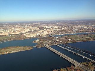
The 14th Street bridges refers to the three bridges near each other that cross the Potomac River, connecting Arlington, Virginia and Washington, D.C. Sometimes the two nearby rail bridges are included as part of the 14th Street bridge complex. A major gateway for automotive, bicycle and rail traffic, the bridge complex is named for 14th Street, which feeds automotive traffic into it on the D.C. end.

<span class="mw-page-title-main">BNSF Railway Bridge 5.1</span> Railroad bridge in Portland, Oregon

The BNSF Railway Bridge 5.1, also known as the St. Johns Railroad Bridge or the Willamette River Railroad Bridge, is a through truss railway bridge with a vertical lift that spans the Willamette River in Portland, Oregon, United States. Built by the Spokane, Portland and Seattle Railway (SP&S) and completed in 1908, it was originally a swing-span bridge, and its swing-span section was the longest in the world at the time. However, 81 years later the main span was converted from a swing-type to a vertical-lift type, in order to widen the navigation channel. The lift span is one of the highest and longest in the world. The bridge consists of five sections, with the two sections closest to the bank on each side fixed.

<span class="mw-page-title-main">Tobin Bridge</span> Bridge in Boston, Massachusetts, US

The Maurice J. Tobin Memorial Bridge is a cantilever truss bridge that spans more than two miles (3.2 km) from Boston to Chelsea over the Mystic River in Massachusetts. The bridge is the largest in New England. It is operated by the Massachusetts Department of Transportation and carries U.S. Route 1. It was built between 1948 and 1950 and opened to traffic on February 2, 1950, replacing the former Chelsea Bridge. The 36-foot (11 m)-wide roadway has three lanes of traffic on each of the two levels with northbound traffic on the lower level and southbound traffic on the upper level.

<span class="mw-page-title-main">Crescent City Connection</span> Twin cantilever bridges over the Mississippi River in New Orleans, Louisiana, USA

The Crescent City Connection (CCC), formerly the Greater New Orleans (GNO) Bridge, is a pair of cantilever bridges that carry U.S. Highway 90 Business over the Mississippi River in New Orleans, Louisiana, United States. They are tied as the fifth-longest cantilever bridges in the world. Each span carries four general-use automobile lanes; additionally the westbound span has two reversible HOV lanes across the river.

<span class="mw-page-title-main">Industrial Canal</span> Canal in Louisiana, United States of America

The Industrial Canal is a 5.5 mile (9 km) waterway in New Orleans, Louisiana, United States. The waterway's proper name, as used by the U.S. Army Corps of Engineers and on NOAA nautical charts, is Inner Harbor Navigation Canal (IHNC). The more common "Industrial Canal" name is used locally, both by commercial mariners and by landside residents.

<span class="mw-page-title-main">Huey P. Long Bridge (Baton Rouge)</span> Bridge in Baton Rouge, Louisiana

The Huey P. Long - O.K. Allen Bridge is a truss cantilever bridge over the Mississippi River carrying US 190 and one rail line between East Baton Rouge Parish, Louisiana and West Baton Rouge Parish, Louisiana.

<span class="mw-page-title-main">Frisco Bridge</span> Bridge in Arkansas and Memphis, Tennessee

The Frisco Bridge, previously known as the Memphis Bridge, is a cantilevered through truss bridge carrying a rail line across the Mississippi River between West Memphis, Arkansas, and Memphis, Tennessee.

<span class="mw-page-title-main">Harahan Bridge</span> Bridge between Arkansas and Tennessee, US

The Harahan Bridge is a cantilevered through truss bridge that carries two rail lines and a pedestrian bridge across the Mississippi River between West Memphis, Arkansas, and Memphis, Tennessee. The bridge is owned and operated by Union Pacific Railroad and is the second longest pedestrian/bicycle bridge in the United States. It was built with roadways cantilevered off the sides of the main structure for vehicles. These roadways are owned by the cities of Memphis, Tennessee, and Crittenden County, Arkansas, and were used from 1917–1949, until the Memphis & Arkansas Bridge opened 400 feet (120 m) south of the Harahan. The bridge was named in honor of railroad executive James Theodore Harahan, former president of the Illinois Central Railroad, who was killed in a railroad accident during the construction of the bridge. In February 2011, Union Pacific Railroad officials agreed to the idea of converting the 1917 roadways into a bicycle-pedestrian walkway across the river. In June 2012, Memphis was awarded a $14.9 million federal grant to build the walkway. The overall project was expected to cost $30 million, of which about $11 million was used for the Harahan Bridge portion. Construction was completed in 2016.

<span class="mw-page-title-main">Louisiana Railroad Bridge</span> Bridge in Louisiana, Missouri and Illinois

The Louisiana Railroad Bridge carries a single track rail line across the Mississippi River between Louisiana, Missouri and Pike County, Illinois, United States. Built by the Chicago and Alton Railroad, the structure is currently owned by the Canadian Pacific Kansas City following a series of sales and consolidation in the railroad industry.

<span class="mw-page-title-main">U.S. Route 90 Business (New Orleans, Louisiana)</span> Highway in New Orleans, Louisiana

U.S. Highway 90 Business is a business route of U.S. Highway 90 located in and near New Orleans, Louisiana. It runs 14.25 miles (22.93 km) in a general east–west direction from US 90 in Avondale to a junction with Interstate 10 (I-10) and US 90 in the New Orleans Central Business District.

<span class="mw-page-title-main">Airline Highway</span>

Airline Highway is a divided highway in the U.S. state of Louisiana, built in stages between 1925 and 1953 to bypass the older Jefferson Highway. It runs 115.6 miles (186.0 km), carrying U.S. Highway 61 from New Orleans northwest to Baton Rouge and U.S. Highway 190 from Baton Rouge west over the Mississippi River on the Huey P. Long Bridge. US 190 continues west towards Opelousas on an extension built at roughly the same time.

<span class="mw-page-title-main">Louisiana Highway 1</span> Highway in Louisiana

Louisiana Highway 1 (LA 1) is a state highway in Louisiana. At 431.88 miles (695.04 km), it is the longest numbered highway of any class in Louisiana. It runs diagonally across the state, connecting the oil and gas fields near the island of Grand Isle with the northwest corner of the state, north of Shreveport.

<span class="mw-page-title-main">U.S. Route 90 in Louisiana</span> Highway in Louisiana

U.S. Highway 90 (US 90), one of the major east–west U.S. Highways in the Southern United States, runs through southern Louisiana for 297.6 miles (478.9 km), serving Lake Charles, Lafayette, New Iberia, Morgan City, and New Orleans. Much of it west of Lafayette and east of New Orleans has been supplanted by Interstate 10 (I-10) for all but local traffic, but the section between Lafayette and New Orleans runs a good deal south of I-10.

<span class="mw-page-title-main">ASB Bridge</span> Bridge in and North Kansas City, Missouri

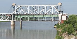
The Armour-Swift-Burlington (ASB) Bridge, also known as the North Kansas City Bridge and the LRC Bridge, is a rail crossing over the Missouri River in Kansas City, Missouri, that formerly also had an upper deck for automobile traffic.

<span class="mw-page-title-main">I-10 Twin Span Bridge</span> Bridge in Louisiana

The I-10 Twin Span Bridge, a nearly 5.5-mile (8.9 km) causeway officially known as the Frank Davis "Naturally N'Awlins" Memorial Bridge, consists of two parallel trestle bridges. These parallel bridges cross the eastern end of Lake Pontchartrain in southern Louisiana from New Orleans to Slidell. The current bridge spans were constructed in the second half of the 2000s after the original bridges were extensively damaged by Hurricane Katrina on August 29, 2005. The first span opened to eastbound traffic on July 9, 2009. On April 7, 2010, the second span was opened to traffic and the old twin spans were permanently closed to traffic.

<span class="mw-page-title-main">Cairo Rail Bridge</span> Bridge in Kentucky and Cairo, Illinois

Cairo Rail Bridge is the name of two bridges crossing the Ohio River near Cairo, Illinois in the United States. The original was an 1889 George S. Morison through-truss and deck truss bridge, replaced by the current bridge in 1952. The second and current bridge is a through-truss bridge that reused many of the original bridge piers. As of 2018, trains like the City of New Orleans travel over the Ohio River supported by the same piers whose construction began in 1887.

<span class="mw-page-title-main">Moses Wheeler Bridge</span> Bridge in Connecticut, United States

Moses Wheeler Bridge carries Interstate 95 over the Housatonic River between Stratford and the Devon section of Milford. The current bridge is a 14-span continuous girder and floorbeam structure that carries three lanes of traffic in each direction, with full inside and outside shoulders. The current bridge, completed in 2016, replaces a pre-existing structure that was completed as part of the original Connecticut Turnpike in 1958. The original bridge was a 34-span plate girder structure with a concrete deck with three 12-foot travel lanes in each direction and no shoulders. The central span of the original bridge over the river's navigation channel included a pin and hanger assembly, which are no longer used in bridge construction in the United States. Construction on the Moses Wheeler Bridge began in 1955 and opened on January 2, 1958.

<span class="mw-page-title-main">U.S. Route 65 in Louisiana</span> Section of U.S. Highway in Louisiana, United States

U.S. Highway 65 (US 65) is a part of the United States Numbered Highway System that spans 966 miles (1,555 km) from Clayton, Louisiana to Albert Lea, Minnesota. Within the state of Louisiana, the highway travels 100.77 miles (162.17 km) from the national southern terminus at US 425/LA 15 in Clayton to the Arkansas state line north of Lake Providence.

References

  1. Betsy Swanson (2003). Historic Jefferson Parish: From Shore to Shore. Pelican Publishing. p. 100.
  2. Andrea Shaw (June 13, 2013), $1.2 billion Huey P. Long Bridge widening to end steering-wheel death grip, Nola, retrieved August 7, 2014
  3. Missouri Department of Transportation (2017). The Merchants Bridge rehabilitation program (PDF) (Grant application). Figure 10: Rail Traffic Volumes Overlaid with Seismic Hazard, 2014.
  4. Nguyên, Trang (August 2, 2014). "Tên đường thành phố". Trẻ Weekly Magazine (in Vietnamese). Garland, Texas. Archived from the original on November 18, 2018. Retrieved August 23, 2018.
  5. The bridge is also known by local Vietnamese Americans as the Huỳnh Phi Long bridge, a phono-semantic matching of Huey P. Long's name in the style of a Vietnamese name. [4]
  6. Marking, Tonja Koob; Snape, Jennifer (2013). Huey P. Long Bridge. Images of America. Charleston, South Carolina: Acadia Publishing. p. 11. ISBN   9781439643457.
  7. Frazier, Ian (June 2, 2014). "Streetscape: Do Not Cross". The New Yorker. p. 26.
  8. "Largest Railroad Bridge Structural Health Monitoring System | CTL Grp". www.ctlgroup.com. Archived from the original on May 14, 2018. Retrieved February 16, 2019.
  9. US0090 over MISSISSIPPI RIVER, BridgeReports.com National Bridge Inventory Data.
  10. "US-90 Huey P. Long Bridge, New Orleans, LA".
  11. "Huey P. Long Bridge". American Society of Civil Engineers. Retrieved January 29, 2022.
  12. "East Bank and West Bank Approaches & Ramps". Archived from the original on June 18, 2012. Retrieved June 29, 2012.
  13. approaches and ramps construction
  14. Carlie Kollath Wells (April 27, 2015). "Train cars blown off tracks on Huey P. Long Bridge, FOX 8 reports". The Times-Picayune.

Original construction

2006 road widening project

General