
The Mississippi River is the second-longest river and chief river of the second-largest drainage system in North America, second only to the Hudson Bay drainage system. From its traditional source of Lake Itasca in northern Minnesota, it flows generally south for 2,340 miles (3,770 km) to the Mississippi River Delta in the Gulf of Mexico. With its many tributaries, the Mississippi's watershed drains all or parts of 32 U.S. states and two Canadian provinces between the Rocky and Appalachian mountains. The main stem is entirely within the United States; the total drainage basin is 1,151,000 sq mi (2,980,000 km2), of which only about one percent is in Canada. The Mississippi ranks as the thirteenth-largest river by discharge in the world. The river either borders or passes through the states of Minnesota, Wisconsin, Iowa, Illinois, Missouri, Kentucky, Tennessee, Arkansas, Mississippi, and Louisiana.

The National Register of Historic Places in the United States is a register including buildings, sites, structures, districts, and objects. The Register automatically includes all National Historic Landmarks as well as all historic areas administered by the U.S. National Park Service. Since its introduction in 1966, more than 90,000 separate listings have been added to the register.

This is a list of properties and districts in Indiana that are listed on the National Register of Historic Places. There are over 1,900 in total. Of these, 39 are National Historic Landmarks. Each of Indiana's 92 counties has at least two listings.

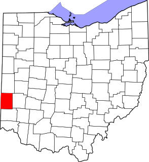
This is a list of properties and districts in Ohio that are listed on the National Register of Historic Places. There are over 4.000 in total. Of these, 73 are National Historic Landmarks. There are listings in each of Ohio's 88 counties.

Pugh's Mill Covered Bridge is a registered historic structure near Oxford, Ohio, listed in the National Register on 1975-06-05. This wooden bridge was built in 1869 over Four Mile (Talawanda) Creek and is one of two remaining covered bridges in Butler County, Ohio. The other is the Bebb Park or State Line covered bridge built in 1868.

Old Blenheim Bridge was a wooden covered bridge that spanned Schoharie Creek in North Blenheim, New York, United States. With an open span of 210 feet (64 m), it had the second longest span of any surviving single-span covered bridge in the world. The 1862 Bridgeport Covered Bridge in Nevada County, California, currently undergoing repairs due to 1986 flooding is longer overall at 233 feet (71 m) but is argued to have a 208 feet (63 m) clear span. The bridge, opened in 1855, was also one of the oldest of its type in the United States. It was destroyed by flooding resulting from Tropical Storm Irene in 2011. Rebuilding of the bridge commenced in 2017 and was completed in 2018.

Eagleville Bridge is a covered bridge located at Eagleville in the towns of Jackson and Salem, Washington County, New York. The bridge, which crosses the Battenkill, is one of 29 historic covered bridges in New York State.
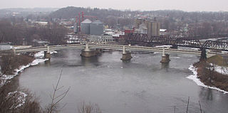
The Zanesville Y-Bridge is a historic Y-shaped three-way bridge that spans the confluence of the Licking and Muskingum Rivers in downtown Zanesville, Ohio. It carries the traffic of U.S. Route 40, as well as Linden Avenue.
This is a list of the National Register of Historic Places listings in Preble County, Ohio.

The Cumberland Covered Bridge, also known as the Matthews Covered Bridge, is a historic covered bridge spanning the Mississinewa River at Jefferson Township and Matthews, Grant County, Indiana. It was originally called the New Cumberland Covered Bridge, it was built in 1877 by William Parks of Marion, Indiana. This Howe Truss bridge is 181 feet (55 m) long. It is the only remaining covered bridge in Grant County.

The McColly Covered Bridge is a historic wooden covered bridge in western Logan County, Ohio, United States. Located in Washington Township near the community of Bloom Center, it is one of two remaining covered bridges in Logan County. It carries County Road 13 over the Great Miami River, approximately 5 miles (8.0 km) south of its source at Indian Lake.
The Bath Covered Bridge is a historic covered bridge over the Ammonoosuc River off US 302 and NH 10 in Bath, New Hampshire. Built in 1832, it is one of the state's oldest surviving covered bridges. It was listed on the National Register of Historic Places in 1976, and underwent a major rehabilitation in the 2010s.

The South Salem Covered Bridge is a historic covered bridge in northwestern Ross County, Ohio, United States. It was built in the 1870s and has been designated a historic site because of its well-preserved historic engineering. Since its construction, it has carried Lower Twin Road over Buckskin Creek in Buckskin Township. The bridge is a wooden Smith truss bridge, built in 1873 according to a design patented by Ohioan Robert Smith in the late 1860s. Eight wooden panels wide, it rests on stone abutments and is covered with a metal roof.
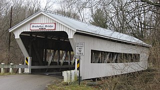
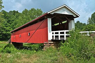
Brubaker Covered Bridge runs across Sandy Run, to the west-northwest of Gratis Township, Preble County, Ohio. It is 85 feet (26 m) in length, and was built in 1887 by Everett S. Sherman. The bridge is of Childs Truss construction.

The Hune Covered Bridge is a historic wooden covered bridge in the southeastern part of the U.S. state of Ohio. Located northeast of the community of Dart, it spans the Little Muskingum River in northeastern Lawrence Township in the eastern part of Washington County. Local bridge builder Rollin Meredith erected it in 1879, using the Long-truss style of truss bridge design; the single-span bridge was named for the locally prominent Hune family. Among its design features are a metal roof, abutments of cut stone, and vertical siding. As a Long truss, the Hune Bridge is a valuable example of nineteenth-century architecture: few examples of this complicated style survive to the present day. In 1976, the Hune Bridge was listed on the National Register of Historic Places, both because of its place in local history and because of its historically significant construction.

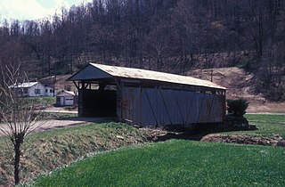
The Teegarden-Centennial Covered Bridge is a covered bridge in Columbiana County, Ohio. The bridge crosses Little Beaver Creek on Eagleton Road, 0.1 miles East of county road 411 near Salem, Ohio. It is currently only open to pedestrian traffic.

The Taylor's Ford Bridge is a historic structure located four miles southeast of Independence, Iowa, United States. It spans the Wapsipinicon River for 271 feet (83 m). In January 1872 the Buchanan County Board of Supervisors contracted with the Wrought Iron Bridge Co. from Canton, Ohio, to build a two-span bridge in the city of Independence for $20,102. It had replaced an earlier span that had been washed away in a flood. Both spans were replaced by a heavier span in 1891. One of the spans was moved to Buffalo Township, and has subsequently been removed. This bridge is the other span. It has been replaced a second time by a heavier bridge, but it remains in place even though it no longer carries vehicle traffic. The bridge was listed on the National Register of Historic Places in 1998.

The Mill Creek Bridge is located north of Cherokee, Iowa, United States. It spans Mill Creek for 207 feet (63 m). On June 24, 1891, a disastrous flood along the Little Sioux River and its tributaries wiped out nearly every bridge in Cherokee County. The following month the county board of supervisors signed a contract with the George E. King Bridge Co. of Des Moines for 17,650 to replace the bridges. This Pratt truss bridge was fabricated by the King Bridge Company of Cleveland, Ohio. It and a similar span over Mill Creek near Larrabee are the only two that remain. This bridge was listed on the National Register of Historic Places in 1998. A modern concrete span, built just upstream in 2006, now carries the road. The old bridge is closed to vehicular traffic.
The Rinard Covered Bridge, near Marietta, Ohio, was built in 1876. It was listed on the National Register of Historic Places in 1976.
The Scottown Covered Bridge, near Scottown, Ohio, was built in 1874. It was listed on the National Register of Historic Places in 1975. It is a Multiple Kingpost covered bridge.


