
The Wye Valley Walk is a long distance footpath in Wales and England following the course of the River Wye.

The River Wye is the fourth-longest river in the UK, stretching some 250 kilometres from its source on Plynlimon in mid Wales to the Severn estuary. For much of its length the river forms part of the border between England and Wales. The Wye Valley is designated an Area of Outstanding Natural Beauty. The Wye is important for nature conservation and recreation, but is severely affected by pollution.
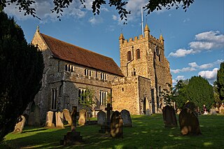
Wye is the smallest town in Britain, located in Kent, England, 5 miles (8.0 km) from Ashford and 12 miles (19 km) from Canterbury. It is the main settlement in the civil parish of Wye with Hinxhill. Hop varieties including Wye Challenger were bred at Wye College and named for the village.

In railroad structures, and rail terminology, a wye or triangular junction is a triangular joining arrangement of three rail lines with a railroad switch at each corner connecting to each incoming line. A turning wye is a specific case.

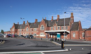
Lydney railway station is a railway station serving the town of Lydney in Gloucestershire, England. It is located on the Gloucester-Newport line. The station is located a mile south of Lydney, and was originally called Lydney Junction, which is now the name of the nearby station on the preserved Dean Forest Railway.

The A449 is a major road in the United Kingdom. It runs north from junction 24 of the M4 motorway at Newport in South Wales to Stafford in Staffordshire.
Hereford railway station serves the city of Hereford, England. Managed by Transport for Wales, it lies on the Welsh Marches Line between Leominster and Abergavenny, is the western terminus of the Cotswold Line and also has an hourly West Midlands Trains service from Birmingham New Street. The station has four platforms for passenger trains and two additional relief lines for goods services.
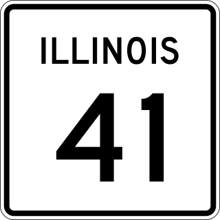
Illinois Route 41 is a north–south highway in rural west-central Illinois. It runs from U.S. Route 136 near Macomb north to U.S. Route 34 and Illinois Route 164 in Galesburg, a distance of 37.53 miles (60.40 km). Illinois 41 is maintained by the Illinois Department of Transportation.

Illinois Route 267 (IL 267) is a north–south highway in the U.S. state of Illinois. It runs from U.S. Route 67 (US 67) and Illinois Route 111 in Godfrey north to Illinois Route 104 and Business Interstate 72 in Jacksonville. This is a distance of 59 miles (95 km). However, the state of Illinois' 2006 data shows the length of Illinois 267 as 39.46 miles (63.50 km), which is the distance from the Illinois 111/267 wye north to BL 72 at Illinois 104.

The A466, also known as the Wye Valley Road, is a road from Hereford, England to Chepstow, Wales via Monmouth, Tintern and the Wye Valley.
David Henry Humm was an American professional football player who played as a quarterback in the NFL from 1975–84 for the Oakland / Los Angeles Raiders, the Buffalo Bills, and the Baltimore Colts. He played college football at the University of Nebraska.

Wye Road is a major arterial road and rural highway that links Sherwood Park from Anthony Henday Drive on the east side of Edmonton to Highway 14 west of Tofield. It is preceded by Sherwood Park Freeway, and east of Highway 21 is designated as Alberta Provincial Highway No. 630, commonly referred to as Highway 630. Wye Road is part of a 40-kilometre-long (25 mi) continuous roadway that runs through Sherwood Park, Edmonton, and St. Albert that includes Sherwood Park Freeway, Whyte Avenue, portions of University Avenue and Saskatchewan Drive, Groat Road, and St. Albert Trail.

National Cycle Route 8 is a route of the National Cycle Network, running from Cardiff to Holyhead. The route passes through the heart of Wales, and is also known by its Welsh name Lôn Las Cymru. It is largely north–south from Holyhead to Cardiff or Chepstow, and in total measures some 400 km (250 mi) in length. Some of its route follows the trackbed of former railway lines, such as Lôn Las Menai, Lôn Eifion, the Mawddach Trail and the Taff Trail; in other places, the route is on public highways.

The Wye Valley Railway was a standard gauge railway that ran for nearly 15 miles (24 km) along the Lower Wye Valley between the towns of Chepstow and Monmouth, crossing several times between Wales and England. Opened on 1 November 1876, it was leased to, and worked by, the Great Western Railway (GWR), before being fully absorbed by the GWR in 1905.

The Coleford, Monmouth, Usk & Pontypool Railway (CMU&PR) was a standard gauge railway of 16 miles (26 km) which ran from Monmouth to Little Mill, near Pontypool in Monmouthshire, Wales. It was intended to convey the mineral products of the Forest of Dean to the ironworks of South Wales, by connecting to the Newport, Abergavenny and Hereford Railway at Little Mill Junction. The NAHR made the onward connection over its Taff Vale Extension line. The CMU&PR intended to acquire the Monmouth Railway, actually a horse-operated plateway, and convert it to locomotive operation.
The Ross and Monmouth Railway was a standard gauge railway of 13 miles (21 km) which ran between Ross-on-Wye, in Herefordshire, England and Monmouth, Wales.
Lydbrook Junction railway station is a disused railway station in England opened by the Ross and Monmouth Railway in 1873, it remained open for 91 years until 1964 when the line finally closed to freight, though passenger services ceased in 1959. The station was constructed in the hamlet of Stowfield approximately half a mile from Lydbrook and its viaduct on the Severn and Wye Railway. It was located approximately 4 miles and 34 chains along the railway from Ross-on-Wye station. In 1874 the Severn and Wye Railway opened a branch from Serridge Junction and Cinderford, passenger services commenced in 1875. All passenger trains along the S&W branch were withdrawn from 1929.
Chepstow East railway station was a temporary station on the South Wales Railway. It was on the opposite bank of the River Wye from Chepstow and was only used for a few months until the river was crossed by a railway bridge. This was about a mile from Chepstow railway station, at the road bridge close to the future junction of the Wye Valley line. It was opened on 19 September 1851 and served as a temporary station while the Chepstow railway bridge was being constructed across the river to link up with the rest of the line. It closed on 19 July 1852, the day that the bridge over the Wye was opened.

Philipp Rudolf Humm is an artist, film director and a former European business executive.

A total of at least sixteen special routes of U.S. Route 460 exist and at least six have been deleted.


