Hunter, New York

Last updated

Hunter, New York
Mary on the Mountain.jpg
Mary of the Mountain Church in Hunter
Greene County NY Hunter town highlighted.svg
Location in Greene County and the state of New York.
New York in United States (US48).svg
Location of New York in the United States
Coordinates: 42°12′31″N74°12′50″W / 42.20861°N 74.21389°W / 42.20861; -74.21389
CountryUnited States
State New York
County Greene
Government
   Town supervisor Sean Mahoney
   Town council
Members
  • Dolph J. Semenza
  • David Kukle
  • Raymond W. Legg
  • Ernest Reale
Area
[1]
  Total90.21 sq mi (233.65 km2)
  Land89.89 sq mi (232.82 km2)
  Water0.32 sq mi (0.83 km2)
Population
 (2020)
  Total3,035
  Density34/sq mi (13/km2)
Time zone UTC-5 (EST)
  Summer (DST) UTC-4 (EDT)
ZIP code
12442
Area code 518
FIPS code 36-039-36178

Hunter is a town located in Greene County, New York, United States. The population was 3,035 at the time of the 2020 census. [2] [3] The town contains two villages, one named Hunter on the west, and the second called Tannersville, as well as a number of hamlets such as Haines Falls, Platte Clove, Lanesville and Edgewood. Additionally, there are three residential parks location within town limits: Onteora Park, Twilight Park and Elka Park. The town is on the southern border of Greene County and abuts the towns of Woodstock and Saugerties, located in Ulster County.

Contents

History

Haines Falls Railroad Station ca. 1900 Haines corners station.jpg
Haines Falls Railroad Station ca. 1900

The town was formed on January 27, 1813, from the town of Windham, but was then called "Edwardsville". The name of "Hunter" was assumed in 1814, named after John Hunter. [4] Afterwards, the town lost some territory to Saugerties in 1814 and to Jewett in 1849.

The area became a popular tourism destination in the late 19th and early 20th centuries. It was served by the Ulster and Delaware Railroad, which brought tourists to resort towns throughout the Catskill Mountains.

Geography

Perspective map and list of landmarks published in 1890 by L.R Burleigh Hunter, N.Y. LOC 75694784.jpg
Perspective map and list of landmarks published in 1890 by L.R Burleigh

According to the United States Census Bureau, the town has a total area of 90.7 square miles (235.0 km2), of which 90.4 square miles (234.3 km2) is land and 0.3 square miles (0.7 km2, or 0.31%) is water.

The southern town line and part of the eastern town boundary are the border of Ulster County. The town is in the Catskill Mountains and the Catskill Park. Many of the Catskill High Peaks, including Hunter Mountain, a 4040 foot mountain that is the highest in the county and the second-highest in the Catskills (after Slade Mountain), are in the town.

Demographics

Historical population
CensusPop.Note
1820 1,025
1830 1,96091.2%
1840 2,0193.0%
1850 1,849−8.4%
1860 1,698−8.2%
1870 1,524−10.2%
1880 1,88223.5%
1890 2,43629.4%
1900 2,78814.4%
1910 2,699−3.2%
1920 2,309−14.4%
1930 2,299−0.4%
1940 2,166−5.8%
1950 2,028−6.4%
1960 1,799−11.3%
1970 1,742−3.2%
1980 2,25229.3%
1990 2,116−6.0%
2000 2,72128.6%
2010 2,7320.4%
2020 3,03511.1%
U.S. Decennial Census [5] [6]

As of the census [7] of 2000, there were 2,721 people, 1,074 households, and 644 families residing in the town. The population density was 30.1 inhabitants per square mile (11.6/km2). There were 2,840 housing units at an average density of 31.4 per square mile (12.1/km2). The racial makeup of the town was 96.95% White, 0.59% Black or African American, 0.11% Native American, 0.15% Asian, 0.04% Pacific Islander, 0.33% from other races, and 1.84% from two or more races. Hispanic or Latino of any race were 2.09% of the population.

There were 1,074 households, out of which 26.6% had children under the age of 18 living with them, 43.8% were married couples living together, 10.1% had a female householder with no husband present, and 40.0% were non-families. 34.2% of all households were made up of individuals, and 12.5% had someone living alone who was 65 years of age or older. The average household size was 2.25 and the average family size was 2.88.

In the town, the population was spread out, with 26.2% under the age of 18, 6.0% from 18 to 24, 23.8% from 25 to 44, 27.9% from 45 to 64, and 16.2% who were 65 years of age or older. The median age was 41 years. For every 100 females, there were 102.8 males. For every 100 females age 18 and over, there were 101.8 males.

The median income for a household in the town was $33,382, and the median income for a family was $42,200. Males had a median income of $35,532 versus $22,188 for females. The per capita income for the town was $18,496. About 11.1% of families and 19.5% of the population were below the poverty line, including 24.0% of those under age 18 and 16.5% of those age 65 or over.

Communities and locations in the town of Hunter

Points of interest

Notable people

Related Research Articles

<span class="mw-page-title-main">Greene County, New York</span> County in New York, United States

Greene County is a county located in the U.S. state of New York. As of the 2020 census, the population was 47,931. Its county seat is Catskill. The county's name is in honor of the American Revolutionary War general Nathanael Greene. The county is part of the Capital District region of the state.

<span class="mw-page-title-main">Taghkanic, New York</span> Town in New York, United States

Taghkanic is a town in Columbia County, New York, United States. The town is in the south-central part of the county. The population was 1,231, at the 2020 US census, down from 1,310 at the 2010 census. "Taghkanic" is an older spelling of "Taconic".

<span class="mw-page-title-main">Halcott, New York</span> Town in New York, United States

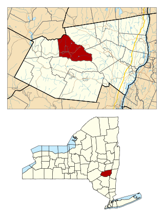
Halcott is a town in Greene County, New York, United States. The population was 249 in 2020, down from 258 at the 2010 census. The town is in the southwestern corner of the county.

<span class="mw-page-title-main">Jewett, New York</span> Town in New York, United States

Jewett is a town centrally located in Greene County, New York, United States. The population was 879 at the 2020 census. The town is named for Freeborn G. Jewett, justice of the New York Supreme Court.

<span class="mw-page-title-main">Lexington, New York</span> Town in New York, United States

Lexington is a town in Greene County, New York, United States. The population was 770 at the 2020 census. The town is in the southwestern part of Greene County.

<span class="mw-page-title-main">Prattsville (town), New York</span> Town in New York, United States

Prattsville is a town in Greene County, New York, United States. The town is in the northwestern part of the county. As of the 2020 census, the population was 774.

Tannersville is a village in Greene County, New York, United States. The village is in the north-central part of the town of Hunter on Route 23A. The population was 568 at the 2020 census.

<span class="mw-page-title-main">Hoosick, New York</span> Town in New York, United States

Hoosick is a town in Rensselaer County, New York, United States. The population was 6,711 at the 2020 census. It was named from the Hoosic River.

<span class="mw-page-title-main">Pittstown, New York</span> Town in New York, United States

Pittstown is a town in Rensselaer County, New York, United States. The population was 5,540 at the 2020 census. It is in the northern part of the county.

<span class="mw-page-title-main">Rockland, New York</span> Town in Sullivan County, New York, US

Rockland is a town in the northern part of Sullivan County, New York, United States. At the 2020 census, the population was 3,290.

<span class="mw-page-title-main">Denning, New York</span> Town in New York, United States

Denning is an isolated town in Ulster County, New York, United States. The population was 493 at the 2020 census. The town is named after an early landowner, William Denning. Denning is located in the western part of the county, deep inside the Catskill Mountains. The location of the town in the Catskill State Park accounts in part for its low population.

<span class="mw-page-title-main">Olive, New York</span> Town in New York, United States

Olive is a town in Ulster County, New York, United States. The town is west of Kingston, New York, and is inside the Catskill Park. The population was 4,226 at the 2020 census.

<span class="mw-page-title-main">Shandaken, New York</span> Town in New York, United States

Shandaken is a town on the northern border of Ulster County, New York, United States, northwest of Kingston, New York. As of the 2020 census, the town had a total population of 2,866. The name is believed to be from an Esopus phrase for "land of rapid waters."

<span class="mw-page-title-main">Johnsburg, New York</span> Town in New York, United States

Johnsburg is a town in the northwestern corner of Warren County, New York, United States. It is part of the Glens Falls Metropolitan Statistical Area. The town population was 2,143 at the 2020 census. The town is named after John Thurman, an early settler and founder. Johnsburg is the largest town in Warren County by area.

<span class="mw-page-title-main">Cairo, New York</span> Town in New York, United States

Cairo is a town in Greene County, New York, United States. The population was 6,644 at the 2020 census. The town is in the southern part of the county, partly in the Catskill Park. The town contains a hamlet, also named Cairo.

<span class="mw-page-title-main">Catskill (town), New York</span> Town in New York, United States

Catskill is a town in the southeastern section of Greene County, New York, United States. The population was 11,298 at the 2020 census, the largest town in the county. The western part of the town is in the Catskill Park. The town contains a village, also called Catskill. The village of Catskill has a well-defined Main Street. There is a public boat launch on the Hudson River called Dutchman's Landing.

<span class="mw-page-title-main">Hunter (village), New York</span> Village in New York, United States

Hunter is a village in Greene County, New York, United States. The population was 429 at the 2020 census. The village is in the northwestern part of the town of Hunter on New York State Route 23A.

<span class="mw-page-title-main">Windham (town), New York</span> Town in New York, United States

Windham is a town in Greene County, New York, United States. The population was 1,708 at the 2020 census. The town was probably named for the town or county of Windham, Connecticut, as many of its earliest settlers came from that state as well as other parts of New England. The town has two nicknames: "Land in the Sky" and "Gem of the Catskills".

<span class="mw-page-title-main">Galway, New York</span> Town in New York, United States

Galway is a town located in Saratoga County, New York, United States. As of the 2020 census, the town had a total population of 3,525. The town contains a village also named Galway. Both the town and village are located in the western part of the county, north of Schenectady.

<span class="mw-page-title-main">Haines Falls, New York</span> Hamlet in New York, United States

Haines Falls is a hamlet located east of Tannersville in the Town of Hunter, in Greene County, New York, United States. Haines Falls is located at 42°11′45″N74°5′49″W. The hamlet of Haines Falls was always a mountain resort town, unlike Hunter and Palenville which had tanneries. Haines Falls is at the head of Kaaterskill Clove and is the former site of the Catskill Mountain House, Kaaterskill Hotel, and Laurel House which sat atop the famous Kaaterskill Falls. In 1825, Thomas Cole, founder of the Hudson River School of landscape painters, did his first Catskill mountain paintings in Haines Falls: Lake with Dead Trees at South Lake and the Kaaterskill Falls.

References

  1. "2016 U.S. Gazetteer Files". United States Census Bureau. Retrieved July 5, 2017.
  2. "Geographic Identifiers: 2010 Demographic Profile Data (G001): Hunter town, Greene County, New York". American Factfinder. U.S. Census Bureau. Retrieved December 29, 2016.[ dead link ]
  3. U.S. Census Bureau, 2020 census results. https://www.census.gov/search-results.html?searchType=web&cssp=SERP&q=Hunter%20town,%20Greene%20County,%20New%20York
  4. Eno, Joel (1916). "A tercentennial history of the towns and cities of New York; their origin, dates and names 1614-1914". Proceedings of the New York State Historical Association. 15 via JSTOR.
  5. "Census of Population and Housing". Census.gov. Retrieved June 4, 2015.
  6. U.S. Census Bureau, 2020 census results. https://www.census.gov/search-results.html?searchType=web&cssp=SERP&q=Hunter%20town,%20Greene%20County,%20New%20York
  7. "U.S. Census website". United States Census Bureau . Retrieved January 31, 2008.
  8. "Official website of Camp Loyaltown". Archived from the original on March 16, 2013. Retrieved May 8, 2013.