Huntington Park High School

Last updated
Huntington Park High School
Address
Huntington Park High School
6020 Miles Avenue

, ,
90255

United States
Coordinates 33°59′12″N118°13′08″W / 33.9866°N 118.2189°W / 33.9866; -118.2189
Information
Type Public
OpenedDecember 2, 1909
School district Los Angeles Unified School District
PrincipalCarlos Garibaldi
Teaching staff61.01 (FTE) [1]
Grades9-12
Number of students1,486 (2019-20) [1]
Student to teacher ratio22.73 [1]
Color(s)Orange & Gray   
MascotSpartan
Rival Bell High School [2]
NewspaperSpartan Shield
Website https://huntingtonparkhs-lausd-ca.schoolloop.com/

Huntington Park High School is a public high school in Huntington Park, California, part of the Los Angeles Unified School District.

Contents

History

The First Grammar School was initially built in 1904. The election was held with 21 registered voters casting ballots. The district was established in 1905, and the first school opened in a 12' board shack, with 13 students of all ages. The families of the students chipped in to hire a young high school girl as teacher, at a monthly fee of $50.

Huntington Park Union High School District was organized in 1909. The cornerstone for the first high school building was laid on December 2, 1909, and the first commencement exercise was held there on June 17, 1910, with Miss Olive Petties being the single graduating student. In January 1932, Huntington Park Union High School District, as a political entity, passed out of existence. The Huntington Park Union High School now became a unit of the Los Angeles City school system, and its official name became Huntington Park High School.

The school itself went through two crises. The first building burned down on 11 October 1911. The second building was wrecked by the violent 1933 Long Beach earthquake. [3]

It was in the Los Angeles City High School District until 1961, when it merged into LAUSD. [4]

In 2005, South East High School in South Gate opened, relieving Huntington Park. [5] When South East opened, it took over areas in the Huntington Park High boundary within the City of South Gate and Walnut Park; Huntington Park High School previously served all of Walnut Park. [6] [7]

Huntington Park offers a full range of athletic teams. These teams compete against other schools in the district and in the surrounding area. Playing on a team can increase school spirit, build self-confidence, and improve fitness. In 1986 and 1990, Huntington Park High men's gymnastics were CIF all city champions. Of note, the Los Angeles all city gymnastics trophy is retired at Huntington Park High School, since 1990 was the last year city championships were held between Los Angeles county public schools. Tryouts for the teams usually take place the previous semester. For more information on tryouts contact the coach. In order to participate in extra curricular competitions, including both athletic and club competitions, a student must maintain a 2.0 GPA. Eligibility is determined every 10 weeks and is based on the 10- and 20-week report cards.

Fall Sports

Cross Country

Football

Girls Tennis

Girls Volleyball

Winter Sports

Boys Basketball

Girls Basketball

Boys Soccer

Girls Soccer

Spring Sports

Baseball

Boys Lacrosse

Girls Lacrosse

Softball

Track and Field

Boys Tennis

Boys Volleyball

[8]

Demographics

The school serves areas in several municipalities, [9] including most of Huntington Park, [10] most of the Walnut Park census-designated place, [6] and portions of Vernon. [11] Some sections of Huntington Park and Maywood are jointly zoned to Huntington Park and Bell High School in Bell. [10] [12]

As of the school year 2008–09, there were a total of 4,312 students attending the high school. [13]

Students by Ethnicity:

Hispanic 98%

Multiple or No Response < 1%

Black < 1%

Asian < 1%

White < 1%

Filipino < 1%

American Indian/Alaskan Native < 1%

Students by Gender:

Male 52%

Female 48%

Notable faculty

Notable alumni

Related Research Articles

<span class="mw-page-title-main">Bell, California</span> City in California, United States

Bell is an incorporated city in Los Angeles County, California, near the center of the former San Antonio Township. Its population was 35,477 at the 2010 census, down from 36,664 in the 2000 census. Bell is located on the west bank of the Los Angeles River and is a suburb of the city of Los Angeles. At 2.5 square miles (6.5 km2), Bell is the thirteenth-smallest city in the United States with a population of at least 25,000.

<span class="mw-page-title-main">Commerce, California</span> City in California, United States

Commerce is a city located in southeast Los Angeles County, California, United States. The population was 12,823 at the 2010 census, up from 12,568 at the 2000 census. It is usually referred to as the City of Commerce to distinguish it from the common noun. It is bordered by Vernon on the west, Los Angeles on the northwest, East Los Angeles on the north, Montebello on the east, Downey and Bell Gardens on the south, and Maywood on the southwest. The Los Angeles River forms part of its southwestern boundary, and the Rio Hondo separates it from Downey. Commerce is served by the Long Beach and Santa Ana freeways, as well as the Metrolink commuter rail service at the Commerce station.

<span class="mw-page-title-main">Cudahy, California</span> City in California, United States

Cudahy is a city located in southeastern Los Angeles County, California, United States. In area, Cudahy is the second smallest city in Los Angeles County after Hawaiian Gardens but with one of the highest population densities of any incorporated city in the United States. It is part of the Gateway Cities region and had a population of 23,805 as of the 2010 U.S. Census.

<span class="mw-page-title-main">East Los Angeles, California</span> Unincorporated community in California, United States

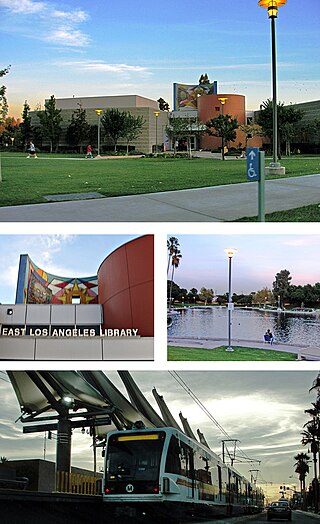
East Los Angeles, or East L.A., frequently recognized by locals as "East LA," is an unincorporated area situated within Los Angeles County, California, United States. According to the United States Census Bureau, East Los Angeles is designated as a census-designated place (CDP) for statistical purposes. The most recent data from the 2020 census reports a population of 118,786, reflecting a 6.1% decrease compared to the 2010 population of 126,496.

<span class="mw-page-title-main">Huntington Park, California</span> City in California, United States

Huntington Park is a city located in the south central region of Los Angeles County, California, United States.

<span class="mw-page-title-main">Maywood, California</span> City in California, United States

Maywood is a gateway city in Los Angeles County. At 1.18 square miles (3.1 km2), Maywood is the third-smallest incorporated city in Los Angeles County. It is bordered by the cities of Bell on the south, Vernon on the north and west, Huntington Park on the southwest, and Commerce on the east.

<span class="mw-page-title-main">South Gate, California</span> City in California, United States

South Gate is the 19th largest city in Los Angeles County, California, United States, with 7.4 square miles (19 km2). South Gate is located 7 miles (11 km) southeast of Downtown Los Angeles. It is part of the Gateway Cities region of southeastern Los Angeles County.

<span class="mw-page-title-main">Walnut Park, California</span> Census-designated place in California, United States

Walnut Park is a census-designated place (CDP) in Los Angeles County, California, United States, adjacent to Florence-Graham, Huntington Park and South Gate. The population was 15,966 at the 2010 census, down from 16,180 at the 2000 census.

<span class="mw-page-title-main">San Pedro, Los Angeles</span> Neighborhood of Los Angeles in California, United States

San Pedro is a neighborhood located within the South Bay and Harbor region of the City of Los Angeles, California, United States. Formerly a separate city, it consolidated with Los Angeles in 1909. The Port of Los Angeles, a major international seaport, is partially located within San Pedro. The district has grown from being dominated by the fishing industry, to a working-class community within the city of Los Angeles, to an increasingly dense community.

<span class="mw-page-title-main">Pico-Union, Los Angeles</span> Neighborhood of Los Angeles in California, United States of America

Pico-Union is a neighborhood in Central Los Angeles, California. The name "Pico-Union" refers to the neighborhood that surrounds the intersection of Pico Boulevard and Union Avenue. Located immediately west of Downtown Los Angeles, it is home to over 40,000 residents.

John H. Francis Polytechnic High School is a secondary school located in the Sun Valley neighborhood of Los Angeles, California, United States. It serves grades 9 through 12 and is a part of the Los Angeles Unified School District. Despite its name, Polytechnic is a comprehensive high school.

Jordan High School, formerly David Starr Jordan High School, is a public comprehensive four-year high school in Los Angeles. Until October 2020, the school was named for David Starr Jordan, the first president of Stanford University. The school colors are Royal blue and white and the mascot is a bulldog.

Bell High School is a public high school in Bell, California, United States. The school, which serves grades 9 through 12, is a part of District 6 of the Los Angeles Unified School District. Bell High’s motto is "Honor lies in honest toil", its mascot is the eagle, and the school colors are purple and gold. They are rivals with the Huntington Park Spartans.

South East High School is a comprehensive four-year high school located in the southeast area of South Gate, California.

<span class="mw-page-title-main">Gardena High School</span> Public school in Gardena, California, United States

Gardena High School (GHS) is a public high school in Harbor Gateway, Los Angeles, California, United States, adjacent to the City of Gardena. It serves grades 9 through 12 and is a part of the Los Angeles Unified School District.

<span class="mw-page-title-main">Maywood Academy High School</span> Public school in Maywood, California

Maywood Academy High School (MAHS) is an alternative high school of the Los Angeles Unified School District, located in Maywood, CA.

The Los Angeles City School District was a school district that served Los Angeles, California, and some adjoining areas between 1870 and 1961.

<span class="mw-page-title-main">Lynwood, California</span> City in California, United States

Lynwood is a city in Los Angeles County, California, United States. At the 2020 census, the city had a total population of 67,265, down from 69,772 at the 2010 census. Lynwood is located near South Gate and Compton in the central portion of the Los Angeles Basin. Incorporated in 1921, Lynwood was named after the Lynwood Dairy and Creamery, from which the local station of the Pacific Electric Railway had been named.

<span class="mw-page-title-main">Los Angeles Unified School District</span> California school district serving almost all of Los Angeles and surrounding areas

Los Angeles Unified School District (LAUSD) is a public school district in Los Angeles, California, United States. It is the largest public school system in California in terms of number of students and the 2nd largest public school district in the United States, with only the New York City Department of Education having a larger student population. During the 2022–2023 school year, LAUSD served 565,479 students, including 11,795 early childhood education students and 27,740 adult students. During the same school year, it had 24,769 teachers and 49,231 other employees. It is the second largest employer in Los Angeles County after the county government. The school district's budget for the 2021–2022 school year was $10.7 billion, increasing to $12.6 billion for the 2022–2023 school year.

References

  1. 1 2 3 "Huntington Park Senior High". National Center for Education Statistics. Retrieved November 23, 2021.
  2. Mario Villegas, A 'Classic' for many reasons, ESPN Los Angeles, November 4, 2010
  3. "History". Archived from the original on 2007-09-27. Retrieved 2007-08-23.
  4. "Los Angeles City School District". Los Angeles Unified School District. Archived from the original on 1998-02-07. Retrieved 2020-10-27.
  5. laschools.org
  6. 1 2 "Walnut Park CDP, California Archived 2011-06-07 at the Wayback Machine ." U.S. Census Bureau. Retrieved on July 2, 2010.
  7. "South Gate city, California Archived June 7, 2011, at the Wayback Machine ." U.S. Census Bureau. Retrieved on June 24, 2010.
  8. "Huntington Park HS: Athletics". huntingtonparkhs-lausd-ca.schoolloop.com. Retrieved 2015-11-09.
  9. "Proposed Changes to South East HS Area Schools." Los Angeles Unified School District. Retrieved on June 24, 2010.
  10. 1 2 "Huntington Park city, California Archived 2011-06-07 at the Wayback Machine ." U.S. Census Bureau. Retrieved on July 2, 2010.
  11. "Zoning Map." City of Vernon. Retrieved on June 2, 2010.
  12. "Maywood city, California Archived June 7, 2011, at the Wayback Machine ." U.S. Census Bureau. Retrieved on July 2, 2010.
  13. http://search.lausd.k12.ca.us/cgi-bin/fccgi.exe?w3exec=school.profile.content&which=8700 [ bare URL ]
  14. Woo, Elaine (2013-01-14). "Youngest on Schindler's list". Los Angeles Times . Archived from the original on 2013-02-05. Retrieved 2013-02-03.
  15. "Huntington Park High School Class of 1950".