Hurricane Beryl

Last updated

Map key
  Tropical depression (≤38 mph, ≤62 km/h)
  Tropical storm (39–73 mph, 63–118 km/h)
  Category 1 (74–95 mph, 119–153 km/h)
  Category 2 (96–110 mph, 154–177 km/h)
  Category 3 (111–129 mph, 178–208 km/h)
  Category 4 (130–156 mph, 209–251 km/h)
  Category 5 (≥157 mph, ≥252 km/h)
  Unknown
Storm type
Disc Plain black.svg Tropical cyclone
Solid black.svg Subtropical cyclone
ArrowUp.svg Extratropical cyclone, remnant low, tropical disturbance, or monsoon depression

A vigorous tropical wave with a large amount of convection, or thunderstorms, moved off the coast of Africa on July 1. However, most of the convective activity diminished as it moved west-southwestwards. [1] Late on July 3, the NHC began tracking this disturbance while it was over the eastern tropical Atlantic for tropical cyclogenesis. [2] The wave quickly organized over the next two days, with a concentrated area of thunderstorms over the low-level center and rainbands developing over the southern side of the disturbance. [1] At 12:00 UTC on July 4, the wave organized into a tropical depression about 1,500 miles (1,300 nautical miles) west-southwest of the Cape Verde Islands. [1] [3] At 00:00 UTC on July 5, the depression strengthened into Tropical Storm Beryl while located at 10°06′N38°00′W / 10.1°N 38.0°W / 10.1; -38.0 ; [1] this was farther southeast than any other Atlantic cyclone on record so early in the calendar year. [4] Due to its very small size, Beryl was prone to very quick changes in intensity, as the storm's tiny inner core could quickly spin up or spin down, depending on the atmospheric conditions. [5] A mid-level eye becoming apparent as the system was consolidating on July 5. [6] Despite relatively cool waters, Beryl began a period of rapid intensification late on July 5. [1] The storm developed a 5 nmi (9.3 km) pinhole eye under a central dense overcast. [7] Beryl strengthened into a hurricane at 06:00 UTC on July 6, becoming the third-earliest hurricane to form in the tropical Atlantic Ocean, behind the 1933 Trinidad hurricane and Hurricane Elsa of 2021, [1] [8] and the easternmost Atlantic hurricane to form from a tropical wave prior to the month of August since reliable records began in 1850. [9] [10] Simultaneously, the small cyclone's pinhole eye became visible. [1] [11] [12]

Throughout the day, the strengthening trend leveled off, and Beryl's eye became cloud-filled. [13] By 21:00 UTC on July 6, Beryl lost its pinhole eye as it tracked towards an environment of higher wind shear. [1] [14] The storm began to gain latitude on July 7, as the storm began losing organization. [14] Dry air began to infiltrate the core of the hurricane, causing its center to become exposed, and Beryl soon weakened back to a tropical storm at 12:00 UTC on July 7. [1] [15] Beryl continued to quickly weaken as it accelerated towards the west-northwest. [16] This trend of rapid weakening continued as wind shear increased upon the system, reducing the storm's structure into a swirl of mid- and low-level clouds. [17] An Air Force Hurricane Hunter aircraft found no evidence of a closed circulation center, [18] and radar from Martinique found no little to no circulation within the bursts of convection. [19] Thus, at 12:00 UTC on July 8, Beryl degenerated into an open trough while located just 60 miles northeast of Martinique. [1] The NHC opted to continue advisories, however, as it was impacting Dominica, discontinuing them afterwards. [19] The National Hurricane Center noted that Beryl had a chance to redevelop near The Bahamas after wind shear decreased. [20] [21]

Subtropical Storm Beryl at its secondary peak intensity on July 14 Beryl 2018-07-14 1440Z.jpg
Subtropical Storm Beryl at its secondary peak intensity on July 14

The remnants continued moving westward into the eastern Caribbean while continuing to have tropical storm-force winds, due to a vigorous mid-level circulation. [1] After passing south of Puerto Rico, the remnants eventually moved ashore in the Dominican Republic with gale-force winds, early on July 10. [22] Strong upper-level winds prevented any redevelopment of the remnants of Beryl for several days as it moved across the island, and as it passed through the Bahamas into the Western Atlantic. [23] The remnants moved northward and then northeastward around a subtropical ridge. [1] As Beryl's remnants were located over the Bahamas, they became elongated and stretched several hundred miles across. [24] By July 13, however, conditions became slightly more favorable for redevelopment, and the remnants of Beryl spawned a new circulation near the associated thunderstorms, though the remnants remained too disorganized for redevelopment at the time. [25]

The circulation became well-defined early on July 14, and due to influence from a baroclinic trough, thunderstorms developed and persisted near the storm's center, with gale-force winds detected east of the center. [26] [27] After continued reorganization, Beryl was re-designated as a subtropical storm at 12:00 UTC that day, while located well off the East Coast of the United States. [1] While convection and the strongest winds were near the center, the storm was deemed subtropical due it interacting with the upper-level trough. [26] Convection decreased somewhat after Beryl was redesignated, though the remaining convection organized into a curved rainband. Beryl's center possibly reformed to the north into the rainband. [28] Beryl reached its secondary peak intensity soon afterward, at 00:00 UTC on July 15, with maximum winds of 40 mph (64 km/h) and a pressure of 1,005 mbar (29.7 inHg). [1] However, the rejuvenated storm soon began to weaken as nearby dry air intruded and weakened showers and thunderstorms associated with the storm, and impinging northwesterly shear further served to remove thunderstorm activity. [29] Early on July 15, water vapor imagery indicated that Beryl had become fully intertwined with and embedded within a cold-core low, causing the subtropical cyclone to slow down drastically over the warm waters of the Gulf Stream. This incited thunderstorm formation, with an eye-like feature forming, surrounded by a "small donut ring" of convection. [30] Later that day, however, Beryl degraded to a low to mid-level swirl of shallow clouds, while continuing on a northeastward course. [31] After lacking thunderstorm activity near the center for twelve hours, Beryl degenerated into a remnant low at 03:00 UTC on July 16. [32] Beryl's remnant low subsequently degenerated into a trough just south of Newfoundland on the next day. [1]

Preparations and impact

The remnants of Beryl damaged or destroyed more than 2,000 structures. Total damage from the storm was estimated to be in the millions (2018 USD). [33]

Lesser Antilles

Remnants of Beryl over Puerto Rico on July 9, with Hurricane Chris appearing off of the United States East Coast Tropical Storm Chris, Beryl's Remnants, and More Saharan Dust over the Atlantic (42666363464).png
Remnants of Beryl over Puerto Rico on July 9, with Hurricane Chris appearing off of the United States East Coast

On July 6, the Government of France issued a tropical storm watch for its overseas collective Saint Barthélemy. On July 7, the Government of France issued a tropical storm watch for Guadeloupe and its overseas collective Saint Martin in the Leeward Islands. [34] In preparation for the hurricane's arrival, the Government of Barbados issued a hurricane watch for Dominica in the Windward Islands and a tropical storm watch for Barbados in the Lesser Antilles on July 6. At the same time, the Government of St. Lucia issued a tropical storm watch for St. Lucia. Earlier, France had issued a tropical storm watch for Martinique, also in the Windward Islands. The next day, the Government of Barbados replaced the hurricane watch with a tropical storm warning as Beryl weakened before making landfall. [35] On July 8, the Government of Dominica ordered a curfew and declared a state of emergency ahead of the storm's passage. [36] Dominican prime minister Roosevelt Skerrit told people to store water since the government shut down the water system as a protective measure. [37] Skerrit said in a public address, "We have to continue to take the situation very seriously.[...]Move now. Go to your relatives.[...]Go to the shelters." [38] Workmen at a resort in Dominica fortified the roofs on the cottages that survived Hurricane Maria. [37]

Beryl brought heavy rain and thunderstorms to Guadeloupe. Thunderstorms began on the evening of July 9 and lasted throughout the night. Localized amounts of 3.9 in (100 mm) were reported throughout the island. [39] Rainfall peaked at 7.8 in (199 mm) in Saint-Claude; wind gusts averaged 50 to 56 mph (80 to 90 km/h) island-wide with a peak of 62 mph (99 km/h) in Le Moule. [1] The resulting damage was limited, with some trees and power lines downed and localized flooding from runoff. [40] The island remained on an Orange Warning until July 10, after the bulk of the rain passed due to a threat for isolated squally weather. [39] Impacts in Dominica was minimal, with no flooding reported. [41]

U.S. Caribbean territories

Preliminary rainfall totals for Puerto Rico and the U.S. Virgin Islands. The darker the color, the more rain that fell. BerylPRRainfall.png
Preliminary rainfall totals for Puerto Rico and the U.S. Virgin Islands. The darker the color, the more rain that fell.

Flash flood watches and warnings were issued for most of the island of Puerto Rico by the National Weather Service in San Juan. [42] On July 6, the Governor of Puerto Rico, Ricardo Rosselló, issued a state of emergency for the island, amid concerns that enhanced rainfall from Beryl or its remnants could lead to flash floods and mudslides, damaging infrastructure that was still recovering from hurricanes Irma and Maria from the previous season. [43] Governor Rosselló reported that work will be suspended on July 9 for public employees. [44] The governor and the Emergency Management and Disaster Administration met with mayors of cities and towns to discuss preparations ahead of the storm. [45] The government opened 42 shelters for citizens to obtain relief from Beryl due to the demand of mayors around the territory. [46] Long lines were reported at supermarkets as people shopped for food and water. [37] Puerto Rican residents were filled with anxiety leading up to the storm. A government mental-health hotline recorded a spike in calls in the days leading up to the storm. [47] The Environmental Protection Agency (EPA) and FEMA staff monitored Beryl in case it made landfall in Puerto Rico and the United States Virgin Islands (USVI). The EPA and FEMA worked with the government of Puerto Rico and the USVI to rebuild structures damaged by Hurricane Maria and prepare residents for Beryl and future storms. The EPA stationed approximately 60 employees in Puerto Rico and the USVI. [48]

Mass power outages were reported on the U.S. Virgin Island of St. Croix, and officials ordered closures of schools and government offices. [41] [1] Due to the effects of previous Hurricanes Irma and Maria, over 60,000 people in Puerto Rico had blue tarps provided by FEMA as temporary roofs. However, tarps were easily blown off due to strong wind gusts from Beryl's remnants. [46] Lieutenant Governor Luis Rivera Marín reported that some rivers began flooding by noon local time on July 9. [47] Rainfall was the heaviest in Eastern Puerto Rico, where over 8 inches of rain fell. [49] The enhanced rainfall also triggered flash flooding that closed several roadways and downed several trees. A landslide was reported in the town of Naranjito, although there were no reports of fatalities or injuries. [50] A tree was blown down onto a road in Guayama. [51] Floodwaters entered a residence in Las Piedras, trapping three people. [52] The Fajardo River overflowed its banks, causing a road to be impassable. [53] Vehicles were trapped on Puerto Rico Highway 909 near Humacao after the road was inundated by floodwaters. [54] By the time the storm passed, approximately 47,000 Puerto Ricans lost power on the island as a result of gusty winds from squalls. [1] [55]

Dominican Republic

On July 10, the Dominican Republic Emergency Operations Center issued a red alert for the provinces of San Cristóbal, Greater Santo Domingo, and San Jose de Ocoa and a yellow alert for ten additional provinces. 104 people were evacuated and moved to the homes of relatives. [56] More than 5,000 government workers were put on standby to respond to flooding. [57]

Heavy rainfall caused by the remnants of Beryl flooded hundreds of homes in the Dominican Republic. Countrywide, the Emergency Operations Center reported that the floods left around 11,740 people displaced. In addition, 19 communities were reported isolated due to flooding; 1,586 homes were damaged with four destroyed. Three bridges were damaged. [58] The National Institute of Potable Waters and Sewers reported that 75 aqueducts were out of service due to the floods. [57] Electrical companies reported that 138,948 customers were affected, mostly in Greater Santo Domingo and San Pedro de Macorís. [59] A peak rainfall amount of 9.2 in (230 mm) fell in the country, far exceeding the 4 in (100 mm) forecast by the National Meteorological Office (Onamet). [57]

The floods left 130,000 people in the capital city of Santo Domingo without power. [60] The National District received 9.1 in (230 mm) of rain in the first eight hours. Several sectors of the capital were flooded, and deficiencies in the drainage system in Greater Santo Domingo led major roadways and highways to be inundated. [57] In San Cristóbal Province, the worst hit areas included the Municipality of Villa Altagracia, and other areas near the Haina River. A peak rainfall amount of 4.2 in (106 mm) was recorded. [57] The Haina River overflowed, causing flooding up to roof height in some areas such as Manoguayabo, where emergency rescues were carried out. [60] The governor of the province reported that 700 homes were flooded and the walls of two schools collapsed amid heavy rains and winds. The floods left 900 people displaced and floodwaters at a police station were knee-high. [61] The winds and downpours caused the diversion of two flights coming from South America to the Las Américas International Airport as well as the delay of the departure of several flights to the United States. [59]

Elsewhere

The remnants of Beryl caused locally heavy rainfall in The Bahamas. NASA's Global Precipitation Measurement mission core satellite found scattered thunderstorms causing torrential rainfall on some of the islands. The satellite estimated rainfall at a rate of more than 1.6 in (41 mm) on Crooked Island. [62] As Beryl was redeveloping near Bermuda, a peak rainfall amount of 0.24 in (6.1 mm) was recorded, along with a peak wind gust of 37 mph (60 km/h). [63] Post-Tropical Storm Beryl had little impact on Canada, as it mainly affected marine areas with winds below gale-force. No precipitation directly related to Beryl affected southeastern Newfoundland. [64]

See also

Related Research Articles

<span class="mw-page-title-main">2003 Atlantic hurricane season</span>

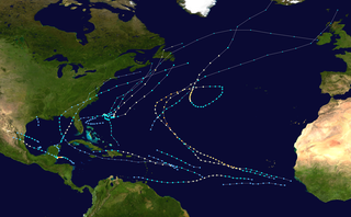
The 2003 Atlantic hurricane season was a very active season with tropical cyclogenesis occurring before and after the official bounds of the season—the first such occurrence since the 1970 season. The season produced 21 tropical cyclones, of which 16 developed into named storms; seven of those attained hurricane status, of which three reached major hurricane status. The strongest hurricane of the season was Hurricane Isabel, which reached Category 5 status on the Saffir–Simpson hurricane scale northeast of the Lesser Antilles; Isabel later struck North Carolina as a Category 2 hurricane, causing $3.6 billion in damage and a total of 51 deaths across the Mid-Atlantic region of the United States.

<span class="mw-page-title-main">2000 Atlantic hurricane season</span>

The 2000 Atlantic hurricane season was a fairly active hurricane season, but featured the latest first named storm in a hurricane season since 1992. The hurricane season officially began on June 1, and ended on November 30. It was slightly above average due to a La Niña weather pattern although most of the storms were weak. It was also the only season to have two of the storms affect Ireland. The first cyclone, Tropical Depression One, developed in the southern Gulf of Mexico on June 7 and dissipated after an uneventful duration. However, it would be almost two months before the first named storm, Alberto, formed near Cape Verde; Alberto also dissipated with no effects on land. Several other tropical cyclones—Tropical Depression Two, Tropical Depression Four, Chris, Ernesto, Nadine, and an unnamed subtropical storm—did not impact land. Five additional storms—Tropical Depression Nine, Florence, Isaac, Joyce, and Leslie—minimally affected land areas.

<span class="mw-page-title-main">1982 Atlantic hurricane season</span>

The 1982 Atlantic hurricane season was an extremely inactive Atlantic hurricane season with five named tropical storms and one subtropical storm. Two storms became hurricanes, one of which reached major hurricane status. The season officially began on June 1, 1982, and lasted until November 30, 1982. These dates conventionally delimit the period of each year when most tropical cyclones form in the Atlantic basin. Activity started early with Hurricane Alberto forming on the first day of the season. Alberto threatened the Southwestern Florida coast as a tropical storm, meadering offshore in the southeastern Gulf of Mexico and causing 23 fatalities in Cuba. The next system, a subtropical storm, formed later in June and affected the same area as Alberto, causing $10 million in damage.

<span class="mw-page-title-main">Tropical Storm Dean (2001)</span> Atlantic tropical storm in 2001

Tropical Storm Dean was a strong tropical storm that affected at least twelve islands along its path from the tropical Atlantic Ocean to east of Atlantic Canada in August 2001. Dean developed from a tropical wave on August 22 over the Lesser Antilles, and was initially predicted to intensify further to reach hurricane status. However, strong wind shear quickly weakened Dean to cause it to dissipate on August 23. The remnants turned northward, and redeveloped on August 26 to the north of Bermuda. Located over warm waters and in an area of favorable conditions, Dean steadily strengthened while moving to the northeast, and peaked just below hurricane status on August 27 about 465 miles (748 km) southwest of Newfoundland. The storm subsequently weakened over cooler waters, and became extratropical on August 28.

<span class="mw-page-title-main">Hurricane Daniel (2006)</span> Category 4 Pacific hurricane in 2006

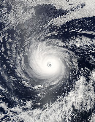
Hurricane Daniel was the second strongest hurricane of the 2006 Pacific hurricane season. The storm affected Hawaii late in its lifetime, causing moderate rainfall and minor damage. The fourth named storm, third hurricane, and second major hurricane of the season, Daniel originated on July 16 from a tropical wave off the coast of Mexico. It tracked westward, intensifying steadily to reach peak winds of 150 mph (240 km/h) on July 22. At the time, the characteristics of the cyclone resembled those of an annular hurricane. Daniel gradually weakened as it entered an area of cooler water temperatures and increased wind shear, and after crossing into the Central Pacific Ocean, it quickly degenerated into a remnant low on July 26, before dissipating two days later.

<span class="mw-page-title-main">Tropical Storm Olga (2007)</span> Atlantic tropical storm in 2007

Tropical Storm Olga was an off-season tropical cyclone that impacted the Greater Antilles. The fifteenth named storm of the 2007 Atlantic hurricane season, Olga developed from a low developed east of the northernmost Lesser Antilles. It slowly acquired tropical characteristics, and late on December 10, the NHC declared it Subtropical Storm Olga while just north of Puerto Rico. It was the first post-season storm since Tropical Storm Zeta in the 2005 season, making the 2007 season one of the few with activity both before and after the official bounds of the hurricane season. Olga was only one of a few out of season tropical cyclones to make landfall. The storm made landfall on December 11 on the eastern tip of the Dominican Republic. Later that evening, Olga transitioned into a tropical storm just after making landfall. Olga tracked over Hispaniola and emerged in the Caribbean Sea. Strong wind shear and dry air caused Olga to weaken into a remnant low early on December 13.

<span class="mw-page-title-main">Meteorological history of Hurricane Jeanne</span>

The meteorological history of Hurricane Jeanne lasted for about two weeks in September 2004. Hurricane Jeanne was the eleventh tropical cyclone, tenth named storm, seventh hurricane, and sixth major hurricane of the 2004 Atlantic hurricane season. It formed from a tropical wave on September 13 near the Lesser Antilles, and encountered favorable enough conditions to reach tropical storm status. Jeanne strengthened further in the eastern Caribbean, becoming a strong tropical storm and developing an eye before striking Puerto Rico on September 15. Remaining well-organized, it attained hurricane status before hitting the eastern tip of the Dominican Republic on September 16.

<span class="mw-page-title-main">2006 Pacific hurricane season</span>

The 2006 Pacific hurricane season was the first above-average season since 1997 which produced twenty-five tropical cyclones, with nineteen named storms, though most were rather weak and short-lived. There were eleven hurricanes, of which six became major hurricanes. Following the inactivity of the previous seasons, forecasters predicted that season would be only slightly above active. It was also the first time since 2003 in which one cyclone of at least tropical storm intensity made landfall. The season officially began on May 15 in the East Pacific Ocean, and on June 1 in the Central Pacific; they ended on November 30. These dates conventionally delimit the period of each year when most tropical cyclones form in the Pacific basin. However, the formation of tropical cyclones is possible at any time of the year.

<span class="mw-page-title-main">Hurricane Kyle (2008)</span> Category 1 Atlantic hurricane in 2008

Hurricane Kyle was a Category 1 hurricane that caused heavy rain and flooding in Puerto Rico in its formative stage and brought hurricane-force winds to Nova Scotia while extratropical. The eleventh tropical storm and sixth hurricane of the 2008 Atlantic hurricane season, Kyle formed from a strong tropical disturbance that tracked across the northeastern Caribbean Sea in the third week of September. As a low pressure area, it moved slowly across Puerto Rico and Hispaniola, dumping torrential rains across those islands.

<span class="mw-page-title-main">Tropical Storm Erika (2009)</span> Atlantic tropical storm in 2009

Tropical Storm Erika was a short-lived tropical cyclone that brought minor impacts to the Lesser Antilles. The fifth named storm of the 2009 Atlantic hurricane season, Erika originated out of a tropical wave on September 1 near the Lesser Antilles. Although it was a disorganized system, it was immediately declared a tropical storm, rather than a tropical depression. Later that day, the system reached its peak intensity with winds of 50 mph (85 km/h) and a barometric pressure of 1004 mbar. Increased wind shear caused the storm to weaken shortly thereafter, with Erika barely maintaining tropical storm-status by September 2. Later that day, the storm passed over the island of Guadeloupe and entered the Caribbean Sea. On September 3, Erika weakened to a tropical depression as the low pressure center became fully displaced from convective activity. Later that day, the system degenerated into a remnant low before dissipating near Puerto Rico on September 4.

<span class="mw-page-title-main">Tropical Storm Bonnie (2010)</span> Atlantic tropical storm in 2010

Tropical Storm Bonnie was a small and rather weak tropical storm that brought squally weather to the northern Caribbean Sea and Gulf Coast of the United States in July 2010. The third tropical cyclone and second named storm of the 2010 Atlantic hurricane season, Bonnie developed from a tropical wave over the Bahamas on July 22. It strengthened to a tropical storm while crossing the islands, and made landfall on the southeastern coast of Florida the following day. Inland, Bonnie weakened to a tropical depression before entering the Gulf of Mexico, where its surface circulation dissipated on July 24. The remnants of the storm moved ashore between Louisiana and Mississippi early on July 25, prompting severe thunderstorm and tornado warnings in the area.

<span class="mw-page-title-main">Hurricane Otto (2010)</span> Category 1 Atlantic hurricane in 2010

Hurricane Otto produced days of torrential rain over much of the northeastern Caribbean in October 2010. Otto originated as a subtropical cyclone lingering north of Puerto Rico on October 6, and transitioned into a tropical storm the next day, the fifteenth of the 2010 hurricane season. Accelerating toward the northeast, Otto strengthened into a Category 1 hurricane on the Saffir–Simpson scale on October 8, attaining peak winds of 85 mph (140 km/h). The storm began weakening due to incompatible surroundings and became extratropical west of the Azores on October 10. Otto was the first Atlantic tropical cyclone to transition from a subtropical storm since Tropical Storm Laura in 2008.

<span class="mw-page-title-main">Tropical Storm Beryl (2012)</span> Atlantic tropical storm in 2012

Tropical Storm Beryl was the strongest off-season Atlantic tropical cyclone on record to make landfall in the United States. The second tropical cyclone of the 2012 Atlantic hurricane season, Beryl developed on May 26 from a low-pressure system offshore North Carolina. Initially subtropical, the storm slowly acquired tropical characteristics as it tracked across warmer sea surface temperatures and within an environment of decreasing vertical wind shear. Late on May 27, Beryl transitioned into a tropical cyclone less than 120 miles (190 km) from North Florida. Early the following day, the storm moved ashore near Jacksonville Beach, Florida, with peak winds of 65 mph (100 km/h). It quickly weakened to a tropical depression, dropping heavy rainfall while moving slowly across the southeastern United States. A cold front turned Beryl to the northeast, and the storm became extratropical on May 30.

<span class="mw-page-title-main">2018 Atlantic hurricane season</span>

The 2018 Atlantic hurricane season was the third in a consecutive series of above-average and damaging Atlantic hurricane seasons, featuring 15 named storms, 8 hurricanes, and 2 major hurricanes, which caused a total of over $50 billion in damages and at least 172 deaths. More than 98% of the total damage was caused by two hurricanes. The season officially began on June 1, 2018, and ended on November 30, 2018. These dates historically describe the period in each year when most tropical cyclones form in the Atlantic basin and are adopted by convention. However, subtropical or tropical cyclogenesis is possible at any time of the year, as demonstrated by the formation of Tropical Storm Alberto on May 25, making this the fourth consecutive year in which a storm developed before the official start of the season. The season concluded with Oscar transitioning into an extratropical cyclone on October 31, almost a month before the official end.

<span class="mw-page-title-main">2019 Atlantic hurricane season</span>

The 2019 Atlantic hurricane season was the fourth consecutive above-average and damaging season dating back to 2016. The season featured eighteen named storms, however, many storms were weak and short-lived, especially towards the end of the season. Six of those named storms achieved hurricane status, while three intensified into major hurricanes. Two storms became Category 5 hurricanes, marking the fourth consecutive season with at least one Category 5 hurricane, the third consecutive season to feature at least one storm making landfall at Category 5 intensity, and the seventh on record to have multiple tropical cyclones reaching Category 5 strength. The season officially began on June 1 and ended on November 30. These dates historically describe the period each year when most tropical cyclones form in the Atlantic basin and are adopted by convention. However, tropical cyclogenesis is possible at any time of the year, as demonstrated by the formation of Subtropical Storm Andrea on May 20, making this the fifth consecutive year in which a tropical or subtropical cyclone developed outside of the official season.

<span class="mw-page-title-main">Hurricane Bertha (2014)</span> Category 1 Atlantic hurricane in 2014

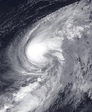
Hurricane Bertha was an unusual tropical cyclone in early August 2014 that attained hurricane status, despite having a disheveled appearance and an abnormally high atmospheric pressure. The third tropical cyclone and second hurricane of the season, Bertha developed from a tropical wave south of Cape Verde was monitored first for possible tropical cyclogenesis on July 26. Over the following days, it slowly developed and acquired gale-force winds and enough convection to be designated as Tropical Storm Bertha early on August 1. A mostly disorganized cyclone, Bertha quickly moved across the Lesser Antilles, clipping the northern end of Martinique, later that day. During its trek across the eastern Caribbean Sea, its circulation became severely disrupted and it may have degenerated into a tropical wave. On August 3, it traversed the Mona Passage and moved over the Southeastern Bahamas where conditions favored development. Despite an overall ragged appearance on satellite imagery, data from Hurricane Hunters indicated it intensified to a hurricane on August 4; it acquired peak winds of 80 mph (130 km/h) that day. Turning north, and later northeast, Bertha soon weakened as it began to merge with an approaching trough to the west. This merger ultimately took place on August 6, at which time Bertha was declared extratropical well to the south of Nova Scotia. The remnant system raced eastward across the Atlantic and later struck the United Kingdom on August 10. Once over the North Sea, the storm stalled for a few days before resuming its eastward track. It was last noted around the Baltic Sea on August 16.

<span class="mw-page-title-main">Hurricane Sergio (2018)</span> Category 4 Pacific hurricane

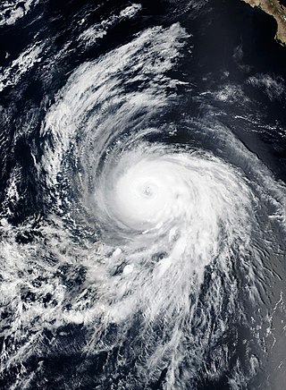
Hurricane Sergio was a powerful and long-lived tropical cyclone that affected the Baja California Peninsula as a tropical storm and caused significant flooding throughout southern Texas in early October 2018. Sergio became the eighth Category 4 hurricane in the East Pacific for 2018, breaking the old record of seven set in 2015. It was the twentieth named storm, eleventh hurricane, and ninth major hurricane of the season.

<span class="mw-page-title-main">Tropical Storm Karen (2019)</span> Atlantic tropical storm in 2019

Tropical Storm Karen was a weak tropical storm that impacted the Lesser Antilles, Virgin Islands, and Puerto Rico in September 2019. The twelfth tropical cyclone and eleventh named storm of the 2019 Atlantic hurricane season, it originated from a tropical wave which entered the tropical Atlantic on September 14. The wave quickly organized as it neared the Windward Islands on September 20, becoming a tropical depression just two days later. The depression strengthened into Tropical Storm Karen later that day, as it moved across the southern Windward Islands. By 18:00 UTC that day, Karen had reached its first peak intensity with 1-minute sustained winds of 45 mph (72 km/h) and a minimum pressure of 1,003 millibars (29.6 inHg). Karen weakened back to a tropical depression at 06:00 UTC on September 23. However, just 12 hours later, Karen re-intensified into a tropical storm. It then entered the central Atlantic, early the next day. Karen began to degrade on September 27, when it weakened into a tropical depression, due to strong wind shear. The system subsequently degenerated into a surface trough later that day.

References

  1. 1 2 3 4 5 6 7 8 9 10 11 12 13 14 15 16 17 18 Avila, Lixion A.; Fritz, Cody (September 20, 2018). Tropical Cyclone Report Hurricane Beryl 4 – 15 July 2018 (PDF) (Report). National Hurricane Center. Archived (PDF) from the original on December 23, 2020. Retrieved October 5, 2020.
  2. Stewart, Stacy (July 3, 2018). Five Day Graphical Tropical Weather Outlook (Report). Miami, Florida: National Hurricane Center. Archived from the original on December 23, 2020. Retrieved November 30, 2020.
  3. Stewart, Stacy (July 5, 2018). Tropical Depression Two Discussion Number 1 (Report). Miami, Florida: National Hurricane Center. Archived from the original on December 23, 2020. Retrieved July 5, 2018.
  4. Philip Klotzbach [@philklotzbach] (July 5, 2018). "Tropical Storm Beryl has formed in the tropical Atlantic – the furthest southeast a named storm has formed this early in the hurricane season on record" (Tweet). Retrieved July 13, 2018 via Twitter.
  5. Dolce, Chris (August 28, 2019). "Why Small Tropical Storms and Hurricanes Can Be Difficult to Forecast". The Weather Channel. Retrieved December 11, 2020.
  6. Robbie Berg (July 5, 2018). Tropical Storm Beryl Discussion Number 2. www.nhc.noaa.gov (Report). Miami, Florida: National Hurricane Center. Archived from the original on December 23, 2020. Retrieved October 5, 2020.
  7. Stewart, Stacy (July 5, 2018). Tropical Storm Beryl Discussion Number 3 (Report). Miami, Florida: National Hurricane Center. Retrieved July 6, 2018.
  8. Marshall Shepherd (July 6, 2018). "Beryl Is The First Atlantic Hurricane Of 2018 – But Keep An Eye On The Carolinas Too". Forbes . Archived from the original on December 23, 2020. Retrieved July 6, 2018.
  9. "Atlantic hurricane best track (HURDAT version 2)" (Database). United States National Hurricane Center. April 5, 2023. Retrieved June 1, 2024.PD-icon.svg This article incorporates text from this source, which is in the public domain.
  10. Brian McNoldy [@BMcNoldy] (July 6, 2018). "Of the 89 pre-August hurricanes on record, Beryl is the easternmost among those that formed from African waves... by a HUGE margin! 1 further east was Dorothy on July 24, and 2 further east were in January (all 3 moving north)" (Tweet). Retrieved July 13, 2018 via Twitter.
  11. Daniel P. Brown (July 6, 2018). Hurricane Beryl Discussion Number 4 (Report). Miami, Florida: National Hurricane Center. Archived from the original on December 23, 2020. Retrieved July 6, 2018.
  12. "Hurricane Beryl: Surprise as US hit by first hurricane of year 40 days earlier than expected". www.independent.co.uk. The Independent. July 7, 2018. Archived from the original on December 23, 2020. Retrieved September 22, 2020.
  13. Berg, Robbie (July 6, 2018). Hurricane Beryl Discussion Number 5 (Report). Miami, Florida: National Hurricane Center. Archived from the original on December 23, 2020. Retrieved November 30, 2020.
  14. 1 2 Berg, Robbie (July 6, 2018). Hurricane Beryl Discussion Number 6 (Report). Miami, Florida: National Hurricane Center. Archived from the original on December 23, 2020. Retrieved November 30, 2020.
  15. Berg, Robbie (July 7, 2018). Tropical Storm Beryl Advisory Number 9 (Report). National Hurricane Center. Archived from the original on December 23, 2020. Retrieved July 7, 2018.
  16. Berg, Robbie (July 7, 2018). Tropical Storm Beryl Discussion Number 10 (Report). National Hurricane Center. Archived from the original on December 23, 2020. Retrieved July 7, 2018.
  17. Beven, Jack (July 7, 2018). Tropical Storm Beryl Discussion Number 11 (Report). National Hurricane Center. Archived from the original on December 23, 2020. Retrieved November 30, 2018.
  18. Stewart, Stacy (July 8, 2018). Tropical Storm Beryl Discussion Number 13 (Report). National Hurricane Center. Archived from the original on December 23, 2020. Retrieved November 30, 2020.
  19. 1 2 Stewart, Stacy (July 8, 2018). Remnants of Beryl Discussion Number 14 (Report). National Hurricane Center. Archived from the original on December 23, 2020. Retrieved November 30, 2020.
  20. Beven, Jack (July 8, 2018). Remnants of Beryl Discussion Number 15 (Report). National Hurricane Center. Archived from the original on December 23, 2020. Retrieved November 30, 2020.
  21. Beven, Jack (July 9, 2018). 5-Day Tropical Weather Outlook (Report). National Hurricane Center. Archived from the original on December 23, 2020. Retrieved July 14, 2018.
  22. Brown, Daniel (July 10, 2018). 5-Day Tropical Weather Outlook. National Hurricane Center (Report). Archived from the original on December 23, 2020. Retrieved July 14, 2018.
  23. Avila, Lixion (July 11, 2018). 5-Day Tropical Weather Outlook (Report). National Hurricane Center. Retrieved July 14, 2018.
  24. Stewart, Stacy (July 11, 2018). 5-Day Tropical Weather Outlook (Report). National Hurricane Center. Archived from the original on December 23, 2020. Retrieved July 14, 2018.
  25. Pasch, Richard (July 13, 2018). 5-Day Tropical Weather Outlook (Report). National Hurricane Center. Archived from the original on December 23, 2020. Retrieved July 14, 2018.
  26. 1 2 Beven, Jack (July 14, 2018). 5-Day Graphical Tropical Weather Outlook (Report). National Hurricane Center. Archived from the original on December 23, 2020. Retrieved July 14, 2018.
  27. Jack Beven (July 14, 2018). Subtropical Storm Beryl Discussion Number 16 (Report). National Hurricane Center. Archived from the original on December 23, 2020. Retrieved August 4, 2018.
  28. Beven, Jack (July 14, 2018). Subtropical Storm Beryl Discussion Number 17 (Report). National Hurricane Center. Archived from the original on December 23, 2020. Retrieved December 21, 2020.
  29. Brown, Daniel (July 15, 2018). Subtropical Storm Beryl Discussion Number 18 (Report). National Hurricane Center. Archived from the original on December 23, 2020. Retrieved December 21, 2020.
  30. Stewart, Stacy (July 15, 2018). Subtropical Storm Beryl Discussion Number 19 (Report). National Hurricane Center. Archived from the original on December 23, 2020. Retrieved December 21, 2020.
  31. Jack Beven (July 15, 2018). Subtropical Storm Beryl Discussion Number 21 (Report). National Hurricane Center. Archived from the original on December 23, 2020. Retrieved July 16, 2018.
  32. Daniel Brown (July 16, 2018). Post-Tropical Cyclone Beryl Discussion Number 22 (Report). Miami, Florida: National Hurricane Center. Archived from the original on December 23, 2020. Retrieved July 16, 2018.
  33. Global Catastrophe Recap July 2018 (PDF) (Report). Aon Benfield. August 9, 2018. Archived from the original (PDF) on August 9, 2018. Retrieved November 13, 2020.
  34. Robbie Berg (July 6, 2018). Hurricane Beryl Advisory Number 6 (Report). National Hurricane Center. Archived from the original on December 23, 2020. Retrieved July 6, 2018.
  35. Berg. Tropical Storm Beryl Advisory Number 9. National Hurricane Center (Report). NOAA. Archived from the original on December 23, 2020. Retrieved July 9, 2018.
  36. Godfrey, Kara (July 9, 2018). "Travel Warning: Caribbean Islands Issue State of Emergency as Tropical Storm Beryl Hits". UK Express. Retrieved December 12, 2020.
  37. 1 2 3 Coto, Danica (July 8, 2018). "Tropical Storm Beryl Set to Slam into Caribbean Islands". The Associated Press. Retrieved December 12, 2020.
  38. Simmons, Roger (July 9, 2020). "Tropical Storm Beryl is No More, but It Could Return Later this Week, Forecasters Say". Orlando Sentinel. Archived from the original on December 23, 2020. Retrieved December 22, 2020.
  39. 1 2 "Redevenue onde tropicale, Béryl arrose l'archipel guadeloupéen" (in French). Outre-mer la 1ère, le portail des Outre-mer. July 9, 2020. Archived from the original on December 23, 2020. Retrieved December 22, 2020.
  40. "L'onde tropicale Beryl balaie la Guadeloupe le 9 juillet avec de fortes pluies orageuses" (in French). Keraunos. July 9, 2018. Archived from the original on December 23, 2020. Retrieved July 14, 2018.
  41. 1 2 Crunden, E.A. (July 10, 2020). "Beryl is Proof that Even the Smallest Storm can be a Threat to Puerto Rico". ThinkProgress. Retrieved December 23, 2020.
  42. Rice, Doyle (July 9, 2020). "Tropical trouble: Beryl's remnants threaten Puerto Rico, as Chris spins near Carolinas". usatoday.com. USA Today. Archived from the original on December 23, 2020. Retrieved September 23, 2020.
  43. Sosnowski, Alex (July 7, 2018). "Hurricane Beryl to raise risk of flooding in Caribbean; State of emergency declared in Puerto Rico". AccuWeather. Archived from the original on August 29, 2018. Retrieved April 15, 2021.
  44. "Puerto Rico ya se prepara para Beryl, el primer huracán de 2018 en el Caribe" (in Spanish). HostelTur. July 7, 2018. Archived from the original on December 23, 2020. Retrieved December 12, 2020.
  45. "Manejo Emergencias de P. Rico convoca a alcaldes en preparación huracán Beryl" (in Spanish). Hoy Los Angeles. July 7, 2018. Retrieved December 14, 2020.
  46. 1 2 Eric Levenson and Leyla Santiago (July 9, 2018). "Puerto Rico deals with rain and flooding as remnants of Beryl move over the island". cnn.com. CNN. Archived from the original on December 23, 2020. Retrieved September 23, 2020.
  47. 1 2 Harris, Alex; Gurney, Kyra (July 9, 2018). "21,000 Homes, Businesses Without Power as Hurricane Beryl's Remains Sweep Puerto Rico". Miami Herald. Archived from the original on December 23, 2020. Retrieved December 21, 2020.
  48. "La EPA se prepara para la temporada de huracanes 2018, sobre la base de las lecciones aprendidas gracias a las respuestas sostenidas de emergencia en 2017" (Press release) (in Spanish). United States Environmental Protection Agency. July 13, 2018. Retrieved December 14, 2020.
  49. Davies, Richard (July 11, 2018). "Breaking News: Dominican Republic and Puerto Rico – Evacuations After Storm Beryl Causes Flooding". floodlist.com. Floodlist. Archived from the original on December 23, 2020. Retrieved September 23, 2020.
  50. "Beryl Knocks Out Power, Floods Homes on Islands Still Recovering From Last Year's Hurricanes – The Weather Channel". Archived from the original on December 23, 2020. Retrieved July 24, 2018.
  51. Event: Thunderstorm Wind in Guayama, Puerto Rico (Report). National Centers for Environmental Information. July 9, 2018. Archived from the original on December 23, 2020. Retrieved December 21, 2020.
  52. Event: Flash Flood in Las Piedras, Puerto Rico (Report). National Centers for Environmental Information. July 9, 2018. Archived from the original on December 23, 2020. Retrieved December 21, 2020.
  53. Event: Flash Flood in Farjado, Puerto Rico (Report). National Centers for Environmental Information. July 9, 2018. Archived from the original on December 23, 2020. Retrieved December 21, 2020.
  54. Event: Flash Flood in Humacao, Puerto Rico (Report). National Centers for Environmental Information. July 10, 2018. Archived from the original on December 23, 2020. Retrieved December 21, 2020.
  55. Breslin, Sean (July 9, 2018). "Beryl's Remnants Trigger Flooding in Puerto Rico, 24,000 Lose Power". The Weather Channel. Archived from the original on December 23, 2020. Retrieved July 9, 2018.
  56. Natural Disasters Monitoring – July 10, 2018 (Report). ReliefWeb. July 10, 2018. Archived from the original on December 23, 2020. Retrieved November 23, 2020.
  57. 1 2 3 4 5 Bonilla, Dilenni; Bello, Alejandra; Vargas, Joan (July 11, 2018). "Tormenta Beryl deja en evidencia deficiencias en drenaje pluvial del Gran Santo Domingo" (in Spanish). El Día. Retrieved December 13, 2020.
  58. "Más de 8,000 dominicanos, desplazados por las lluvias causadas por Beryl". Panamá América (in Spanish). July 10, 2018. Archived from the original on December 23, 2020. Retrieved July 14, 2018.
  59. 1 2 "Inundaciones, desplazados y viviendas afectadas por lluvias de Beryl en República Dominicana" (in Spanish). Cuba Debate. July 10, 2018. Archived from the original on December 23, 2020. Retrieved December 13, 2020.
  60. 1 2 Davies, Richard (July 11, 2018). "Dominican Republic and Puerto Rico – Evacuations After Storm Beryl Causes Flooding". Floodlist. Retrieved November 23, 2020.
  61. Harris, Alex (July 10, 2018). "Beryl deja inundaciones y decenas de miles sin electricidad en República Dominicana" (in Spanish). El Nuevo Herald. Retrieved December 12, 2020.
  62. "NASA's GPM Finds Beryl's Remnants Raining on the Bahamas". NASA Goddard Flight Space Center. July 11, 2018. Archived from the original on December 23, 2020. Retrieved December 13, 2020.
  63. Slightly cooler & drier than average with some occasional thunderstorms. Distant Hurricane Chris & Sub-tropical Storm Beryl have little impact (Report). Bermuda Weather Service. August 1, 2018. Archived from the original on August 8, 2007. Retrieved November 30, 2020.
  64. 2018 Tropical Cyclone Summary (Report). Environment and Climate Change Canada. May 23, 2019. Archived from the original on December 23, 2020. Retrieved December 22, 2020.
Hurricane Beryl
Beryl 2018-07-06 1350Z.jpg
Beryl near peak intensity well to the east of the Lesser Antilles on July 6