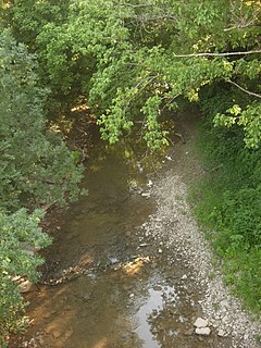
The Mill Creek is a stream in southwest Ohio. It flows 28.4 miles (45.7 km) southwest and south from its headwaters in Liberty Township of Butler County through central Hamilton County and the heart of Cincinnati into the Ohio River just west of downtown. The section of Interstate 75 through Cincinnati is known as the Mill Creek Expressway.

Ault Park is the fourth-largest park in Cincinnati at 223.949 acres (0.9 km²), owned and operated by the Cincinnati Park Board. It lies in the Mount Lookout neighborhood on the city's east side. The hilltop park has an overlook which commands extensive panoramic views of the Little Miami River valley.
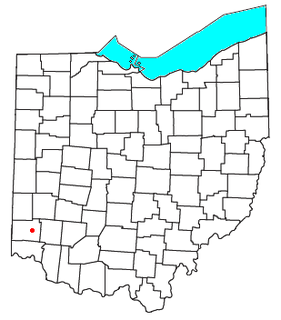
Woodsdale is an unincorporated community in Madison and St. Clair Townships in central Butler County, Ohio, United States about three miles northeast of Hamilton. It was established in 1867 by the Beckett Paper Company and was formerly a stop on the Cincinnati, Hamilton, and Dayton Railroad. An electric generation plant of the Cincinnati Gas and Electric Company is located in Woodsdale. Woodsdale is also the location of the Samuel Augspurger House & Farm and The Augspurger Schoolhouse both of which are on the National Register of Historic Places. Woodsdale was also known for the Woodsdale Island Amusement Park.
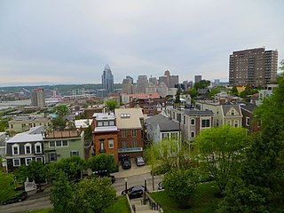
Mount Adams is a geographic landmark and residential neighborhood of Cincinnati, Ohio, located directly east of downtown Cincinnati, south of Walnut Hills, southwest of East Walnut Hills, and west of the East End.
Holy Trinity Church was the first German-speaking Roman Catholic church in Cincinnati, Ohio. It was located at West Fifth Street and Mound Street in Cincinnati's historic West End. The parish was founded in 1834 and the church was dedicated on October 5, 1834.

Cincinnati Work House and Hospital was a registered historic building in the neighborhood of Camp Washington, Cincinnati, Ohio, listed in the National Register on March 3, 1980. The jail was built between 1867 and 1869 on 6 acres (2.4 ha) of land.

Pilgrim Presbyterian Church is a historic church building in the Mount Adams neighborhood of Cincinnati, Ohio, United States, near the Ida Street Viaduct. Built in 1886, it is a Gothic Revival structure built primarily of brick. Constructed by Mount Adams architect and builder Charles E. Iliff, the church features a two-story rectangular floor plan with a prominent central bell tower. Among its other distinctive architectural elements are the rose windows in the main gable, pairs of windows on its second floor, and the symmetry evidenced in the overall design of the building.

The Church of the Annunciation is located at 3547 Clifton Avenue at Resor Street in Cincinnati, Ohio, United States. The Church is located in the Clifton neighborhood. It is part of the Clifton Avenue Historic District. This historic parish was founded in February 1910, and the present building was completed in August 1930. This church was designed by Boston architect Edward T. P. Graham, who was active in both the Archdiocese of Boston and the Archdiocese of Cincinnati in the first half of the 20th century.

Camp Springs is an unincorporated community in Campbell County, Kentucky, United States, ten miles southeast of Cincinnati, Ohio. During the mid-19th century, the area was settled by German immigrants from the Rhine River wine districts.

Corryville is a neighborhood in Cincinnati, Ohio, east of the University of Cincinnati, southeast of Clifton, south and west of Avondale, northwest of Walnut Hills, and north of Mount Auburn. The population was 3,327 at the 2010 census.

Walnut Hills is a neighborhood in Cincinnati, Ohio, United States. One of the city’s oldest hilltop neighborhoods, it is a large diverse area on the near east side of Cincinnati. Eden Park is the gateway to Walnut Hills when driving north from downtown, and the University of Cincinnati is less than 10 minutes away. The neighborhood is redeveloping, restoring many of its buildings and introducing new businesses to the area. The population was 6,495 at the 2010 census.

Sedamsville is a neighborhood in Cincinnati, Ohio. The population was 680 at the 2010 census.
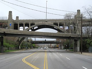
The Waldvogel Viaduct, also called the Waldvogel Memorial Viaduct, was a bridge on the west side of Cincinnati, Ohio, United States, connecting the Sixth Street Expressway with River Road, Elberon Avenue and Warsaw Avenue. The section of Cincinnati is known as Lower Price Hill.

Downtown Cincinnati is the central business district of Cincinnati, Ohio, as well the economic and symbiotic center of the Cincinnati metropolitan area. It also contains a number of urban neighborhoods in the low land area between the Ohio River and the high land areas of uptown. These neighborhoods include Over-the-Rhine, Pendleton, Queensgate, and West End.

Hotel Row is both a National Register and locally listed historic district consisting of one block of early 20th-century commercial buildings, three to four stories high, located on Mitchell Street west of Forsyth Street in the South Downtown district of Atlanta. The buildings were originally hotels with ground level retail shops built to serve the needs of passengers from Terminal Station, opened in 1905. The buildings are the most intact row of early 20th-century commercial structures in Atlanta's original business district. The decline of Hotel Row began in the 1920s due to the increased availability of automobile transportation and the construction of the Spring Street viaduct, which made getting to hotels in the northern part of the city easier. In the 1950s and 1960s, the increase in air travel led ultimately to the demolition of Terminal Station in 1971.
Western Hills is an area in Cincinnati, Ohio. This section of Cincinnati contains Western Hills High School and Dater High School. The area also contains various shopping centers and mini malls. Westwood, Ohio is close to Western Hills.

General Contractor was the J. and F. Harig Co., Cincinnati, Ohio
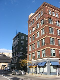
Cincinnati East Manufacturing and Warehouse District is a registered historic district in Cincinnati, Ohio, listed in the National Register on March 12, 1999. It contains 23 contributing buildings. It is roughly bounded E. Court Street, E. 8th Street, Broadway, and Main Street in the central business district.

Mt. Echo Park is an 84-acre (34 ha) urban park in the Price Hill neighborhood of Cincinnati, Ohio, United States. Located on a hilltop, the park offers scenic overlooks of Downtown Cincinnati, the Ohio River, and Northern Kentucky.
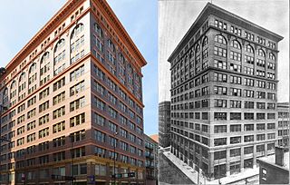
The Textile Building is a historic industrial building in downtown Cincinnati, Ohio. The building was constructed in 1906 in a progressive attempt by the city to centralize its scattered garment and textile industries into singular buildings. Designed in the Commercial and Renaissance Revival styles by Cincinnati native and M.I.T. School of Architecture graduate Gustav W. Drach, the 12-story building is currently used for offices and storage. The building was purchased in 2016, and the new owners hope to preserve the building and continue operating it lease-able office space.
