Ignacio, Colorado

Last updated

Town of Ignacio, Colorado
Ute language: Piinuu
Ignacio, Colorado.JPG
Looking north along Goddard Avenue in Ignacio
La Plata County Colorado Incorporated and Unincorporated areas Ignacio Highlighted 0838535.svg
Location of Ignacio in La Plata County, Colorado.
Coordinates: 37°7′0″N107°38′6″W / 37.11667°N 107.63500°W / 37.11667; -107.63500
Country Flag of the United States (23px).png  United States
State Flag of Colorado.svg  Colorado
County [1] La Plata
Tribe Southern Ute Indian Tribe
Incorporated (town) July 7, 1913 [2]
Government
  Type Statutory Town [1]
Area
[3]
  Total0.43 sq mi (1.12 km2)
  Land0.43 sq mi (1.12 km2)
  Water0.00 sq mi (0.00 km2)
Elevation
[4]
6,453 ft (1,967 m)
Population
 (2020) [5]
  Total852
  Density2,000/sq mi (760/km2)
Time zone UTC-7 (Mountain (MST))
  Summer (DST) UTC-6 (MDT)
ZIP code [6]
81137
Area code 970
FIPS code 08-38535
GNIS feature ID 184487
Website Town of Ignacio

The Town of Ignacio (Ute language: Piinuu) is a Statutory Town in La Plata County, Colorado, United States. The population was 852 at the 2020 United States Census. [5] It is the headquarters of the Southern Ute Indian Reservation.

Contents

Geography

Ignacio is located at 37°7′0″N107°38′6″W / 37.11667°N 107.63500°W / 37.11667; -107.63500 (37.116773, -107.634864). [7]

According to the United States Census Bureau, the town has a total area of 0.273 square miles (0.71 km2), all of it land.

Demographics

Historical population
CensusPop.Note
1920 290
1930 46460.0%
1940 55519.6%
1950 526−5.2%
1960 60915.8%
1970 6130.7%
1980 6678.8%
1990 7207.9%
2000 669−7.1%
2010 6974.2%
2020 85222.2%
U.S. Decennial Census [8]

See also

Related Research Articles

<span class="mw-page-title-main">La Plata County, Colorado</span> County in Colorado, United States

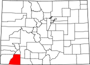
La Plata County is a county located in the U.S. state of Colorado. As of the 2020 census, the population was 55,638. The county seat is Durango. The county was named for the La Plata River and the La Plata Mountains. "La plata" means "the silver" in Spanish.

<span class="mw-page-title-main">Hooper, Colorado</span> Town in Colorado, United States

The Town of Hooper is a Statutory Town located in the San Luis Valley in Alamosa County, Colorado, United States. The population was 81 at the 2020 census.

<span class="mw-page-title-main">Campo, Colorado</span> Town in Colorado, United States

Campo is a Statutory Town located in Baca County, Colorado, United States. The town population was 103 at the 2020 United States Census. The town is situated on the High Plains, straddling U.S. Route 287/385.

<span class="mw-page-title-main">Pritchett, Colorado</span> Town in Colorado, United States

Pritchett is a Statutory Town in Baca County, Colorado, United States. The population was 112 at the 2020 census.

<span class="mw-page-title-main">Vilas, Colorado</span> Town in Colorado, United States

Vilas is a statutory town located in Baca County, Colorado, United States. The population was 98 at the 2020 census.

<span class="mw-page-title-main">Walsh, Colorado</span> Town in Colorado, United States

Walsh is a Statutory Town in Baca County, Colorado, United States. The population was 543 at the 2020 census.

<span class="mw-page-title-main">Poncha Springs, Colorado</span> Town in Colorado, United States

Poncha Springs is a statutory Town in Chaffee County, Colorado, United States. The population was 925 at the 2020 census.

<span class="mw-page-title-main">Cheyenne Wells, Colorado</span> Town in Colorado, United States

Cheyenne Wells is the Statutory Town that is the county seat and the most populous municipality of Cheyenne County, Colorado, United States. The town population was 758 at the 2020 United States Census.

<span class="mw-page-title-main">Ordway, Colorado</span> Town in and county seat of Crowley County, Colorado, United States

Ordway is a Statutory Town in and the county seat of Crowley County, Colorado, United States, that is also the most populous community in the county. The population was 1,066 at the 2020 census.

<span class="mw-page-title-main">Rico, Colorado</span> Town in Colorado, United States

Rico is a town in Dolores County, Colorado, United States. It was settled in 1879 as a silver mining center in the Pioneer Mining District; today it functions as a historic and tourism site. The population was 288 at the 2020 census. Its current form of government is that of a home rule municipality.

<span class="mw-page-title-main">La Veta, Colorado</span> Town in Colorado, United States

La Veta is a statutory town in Huerfano County, Colorado, United States. The town population was 862 as of the 2020 United States Census.

<span class="mw-page-title-main">Bayfield, Colorado</span> Town in Colorado, United States

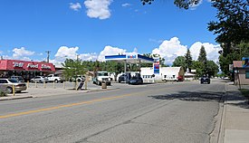
Bayfield is a Statutory Town located in La Plata County, Colorado, United States. The town population was 2,838 at the 2020 United States Census, a +21.65% increase since the 2010 United States Census. Bayfield is part of the Durango, CO Micropolitan Statistical Area.

<span class="mw-page-title-main">Branson, Colorado</span> Town in Colorado, United States

Branson is a Statutory Town located in Las Animas County, Colorado, United States. The town population was 57 at the 2020 United States Census. Branson is the southernmost town in the State of Colorado, located just 0.3 miles (0.48 km) from the New Mexico border.

<span class="mw-page-title-main">Kim, Colorado</span> Town in Colorado, United States

Kim is a Statutory Town in Las Animas County, Colorado, United States. The population was 63 at the time of the 2020 United States Census.

<span class="mw-page-title-main">Del Norte, Colorado</span> Statutory Town in Colorado, United States

Del Norte is a Statutory Town that is the county seat of Rio Grande County, Colorado, United States. The town's name is most commonly pronounced /ˈdɛl nɔɹt/. The town population was 1,458 at the 2020 United States Census.

<span class="mw-page-title-main">South Fork, Colorado</span> Town in Colorado, United States

South Fork is a statutory town in Rio Grande County, Colorado, United States. It lies at the confluence of the South Fork and Rio Grande rivers. The population was 510 at the 2020 census.

<span class="mw-page-title-main">Mountain Village, Colorado</span> Town in Colorado, United States

Mountain Village is a home rule municipality in San Miguel County, southwestern Colorado. It is located just southwest of Telluride, Colorado in the San Juan Mountains. The elevation of the town rises above Telluride to 9,600 feet. The population was 1,264 at the 2020 census.

<span class="mw-page-title-main">Ophir, Colorado</span> Town in San Migel County, Colorado, United States

Ophir is a home rule municipality town governed by a general assembly and is located in San Miguel County, Colorado, United States. It is located two miles from the Ames Hydroelectric Generating Plant, the world's first hydroelectric plant to supply alternating current electricity for an industrial purpose (mining). The population was 197 at the 2020 census.

<span class="mw-page-title-main">Nunn, Colorado</span> Town in Colorado, United States

Nunn is a Statutory Town in Weld County, Colorado, United States. The population was 504 at the 2020 census.

<span class="mw-page-title-main">Pierce, Colorado</span> Town in Colorado, United States

Pierce is a Statutory Town in Weld County, Colorado, United States. The population was 1,097 at the 2020 census. The town is a rural agricultural community located on the Colorado Eastern Plains along U.S. Highway 85 north of Greeley.

References

  1. 1 2 "Active Colorado Municipalities". State of Colorado, Department of Local Affairs. Archived from the original on December 12, 2009. Retrieved September 1, 2007.
  2. "Colorado Municipal Incorporations". State of Colorado, Department of Personnel & Administration, Colorado State Archives. December 1, 2004. Retrieved September 2, 2007.
  3. "2019 U.S. Gazetteer Files". United States Census Bureau. Retrieved July 1, 2020.
  4. "US Board on Geographic Names". United States Geological Survey. October 25, 2007. Retrieved January 31, 2008.
  5. 1 2 United States Census Bureau. "Ignacio town; Colorado" . Retrieved April 22, 2023.
  6. "ZIP Code Lookup". United States Postal Service. Archived from the original (JavaScript/HTML) on November 4, 2010. Retrieved October 13, 2007.
  7. "US Gazetteer files: 2010, 2000, and 1990". United States Census Bureau. February 12, 2011. Retrieved April 23, 2011.
  8. "Census of Population and Housing". Census.gov. Retrieved June 4, 2015.