Iliff, Colorado

Last updated

Town of Iliff, Colorado
Iliff, Colorado.JPG
Iliff, Colorado sign at the west end of town.
Logan County Colorado Incorporated and Unincorporated areas Iliff Highlighted 0838590.svg
Location of Iliff in Logan County, Colorado.
Coordinates: 40°45′32″N103°3′57″W / 40.75889°N 103.06583°W / 40.75889; -103.06583
Country Flag of the United States (23px).png  United States
State Flag of Colorado.svg  Colorado
County [1] Logan
Incorporated (town) February 20, 1906 [2]
Government
  Type Statutory Town [1]
Area
[3]
  Total0.19 sq mi (0.49 km2)
  Land0.19 sq mi (0.49 km2)
  Water0.00 sq mi (0.00 km2)
Elevation
[4]
3,835 ft (1,169 m)
Population
 (2020) [5]
  Total246
  Density1,300/sq mi (500/km2)
Time zone UTC-7 (Mountain (MST))
  Summer (DST) UTC-6 (MDT)
ZIP code [6]
80736
Area code 970
FIPS code 08-38590
GNIS feature ID 171118
Website www.facebook.com/p/Iliff-CO-100069572164938/

The Town of Iliff is a Statutory Town located in Logan County, Colorado, United States. The population was 246 at the 2020 United States Census. [5]

Contents

History

The town was named for John Wesley Iliff, a cattleman who owned a ranch near the town site. [7] [8]

The people of Iliff have proven to be a resilient folk, surviving a blizzard in 1949 and a flood in 1968. Iliff resides on the fertile banks of the South Platte River. The South Platte has been a cornerstone to the community.

The first building constructed was a Post Office and Real Estate Office in 1870. On January 6, 1885, the city was surveyed and on May 4 of that year, a school district was organized. By 1887 a grocery store and lumber yard were in business. The Iliff Bank was established in 1907. By 1915 there was a Baptist Church and a John Deere Implement Dealership added to the town. The Farmer’s Alfalfa Milling Company started in 1918. There were also two doctors, Daniels and Houff, who owned a drug store. In 1920 the Glory Park Theater opened. In 1923 a town Marshall was hired and an old rail boxcar was used as a jail. In 1928 the Catholic Church was built.

The growth declined during the depression, and again during World War II. In 1957 there were eleven businesses that slowly diminished with more people willing to drive 12 miles to Sterling, CO and the opening of Interstate 76, which took all but local travelers off of state highway 138.

Geography

Iliff is located at 40°45′32″N103°03′57″W / 40.758911°N 103.065841°W / 40.758911; -103.065841 . [9]

According to the United States Census Bureau, the town has a total area of 0.2 square miles (0.52 km2), all of it land.

Demographics

Historical population
CensusPop.Note
1920 238
1930 26611.8%
1940 32221.1%
1950 235−27.0%
1960 204−13.2%
1970 193−5.4%
1980 21813.0%
1990 174−20.2%
2000 21322.4%
2010 26624.9%
2020 246−7.5%
U.S. Decennial Census

See also

Related Research Articles

<span class="mw-page-title-main">Logan County, Colorado</span> County in Colorado, United States

Logan County is a county located in the U.S. state of Colorado. As of the 2020 census, the population was 21,528. The county seat is Sterling. The county was named for General John A. Logan.

<span class="mw-page-title-main">Ordway, Colorado</span> Town in and county seat of Crowley County, Colorado, United States

Ordway is a Statutory Town in and the county seat of Crowley County, Colorado, United States, that is also the most populous community in the county. The population was 1,066 at the 2020 census.

<span class="mw-page-title-main">Kiowa, Colorado</span> Town in Colorado, United States

Kiowa is a home rule municipality town and the county seat of Elbert County, Colorado, United States. The town population was 725 at the 2020 United States Census.

<span class="mw-page-title-main">Arriba, Colorado</span> Town in Lincoln County, Colorado, United States

Arriba is a Statutory Town located in Lincoln County, Colorado, United States. The town population was 202 at the 2020 United States census. Arriba is the Spanish word for "on high" or "above others."

<span class="mw-page-title-main">Atwood, Colorado</span> Census Designated Place in Colorado, United States

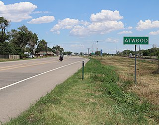
Atwood is an unincorporated town, a post office, and a census-designated place (CDP) located in and governed by Logan County, Colorado, United States. The CDP is a part of the Sterling, CO Micropolitan Statistical Area. The Atwood post office has the ZIP Code 80722. At the United States Census 2020, the population of the Atwood CDP was 138.

<span class="mw-page-title-main">Crook, Colorado</span> Town in Colorado, United States

The Town of Crook is a Statutory Town in Logan County, Colorado, United States. The town population was 133 at the 2020 United States Census. Crook is a part of the Sterling, CO Micropolitan Statistical Area.

<span class="mw-page-title-main">Merino, Colorado</span> Town in Colorado, United States

The Town of Merino is a Statutory Town in Logan County, Colorado, United States. The town population was 281 at the 2020 United States Census.

<span class="mw-page-title-main">Padroni, Colorado</span> Census Designated Place in Colorado, United States

Padroni is an unincorporated town, a census-designated place (CDP), and a post office located in and governed by Logan County, Colorado, United States. The CDP is a part of the Sterling, CO Micropolitan Statistical Area. The Padroni post office has the ZIP Code 80745. At the United States Census 2020, the population of the Padroni CDP was 75.

<span class="mw-page-title-main">Peetz, Colorado</span> Town in Colorado, United States

Peetz is a Statutory Town in Logan County, Colorado, United States. The population was 213 at the 2020 census.

<span class="mw-page-title-main">Sterling, Colorado</span> City in Colorado, United States

Sterling is a home rule municipality and the county seat and most populous municipality of Logan County, Colorado, United States. Sterling is the principal city of the Sterling, CO Micropolitan Statistical Area. The city population was 13,735 at the 2020 census.

<span class="mw-page-title-main">Julesburg, Colorado</span> Town in Colorado, United States

Julesburg is the statutory town that is the county seat and the most populous municipality of Sedgwick County, Colorado, United States. The population was 1,307 at the 2020 United States Census.

<span class="mw-page-title-main">Evans, Colorado</span> City in Colorado, United States

The City of Evans is a home rule municipality located in Weld County, Colorado, United States. The city population was 22,165 at the 2020 United States Census, a 19.57% increase since the 2010 United States Census. Evans is a part of the Greeley, CO Metropolitan Statistical Area and the Front Range Urban Corridor.

<span class="mw-page-title-main">Kersey, Colorado</span> Town in Weld County, Colorado, United States

The Town of Kersey is a Statutory Town in Weld County, Colorado, United States. The population was 1,495 at the 2020 United States Census.

<span class="mw-page-title-main">LaSalle, Colorado</span> Town in Colorado, United States

The Town of LaSalle is a Statutory Town in Weld County, Colorado, United States. The town population was 2,359 at the 2020 United States Census.

<span class="mw-page-title-main">Nunn, Colorado</span> Town in Colorado, United States

Nunn is a Statutory Town in Weld County, Colorado, United States. The population was 504 at the 2020 census.

<span class="mw-page-title-main">Pierce, Colorado</span> Town in Colorado, United States

Pierce is a Statutory Town in Weld County, Colorado, United States. The population was 1,097 at the 2020 census. The town is a rural agricultural community located on the Colorado Eastern Plains along U.S. Highway 85 north of Greeley.

<span class="mw-page-title-main">Platteville, Colorado</span> Town in Colorado, United States

Platteville is a Statutory Town in Weld County, Colorado, United States. The population was 2,955 at the 2020 census. It is adjacent to Fort Vasquez on U.S. Highway 85.

<span class="mw-page-title-main">Raymer, Colorado</span> Town in Colorado, United States

The Town of Raymer is a Statutory Town located in Weld County, Colorado, United States. The population was 110 at the U.S. Census 2020.

<span class="mw-page-title-main">Severance, Colorado</span> Town in the United States

Severance is a Statutory Town in Weld County, Colorado, United States. The population was 7,683 at the 2020 census. The town is located on the Colorado Eastern Plains, northwest of Greeley, a crossroads of county roads.

<span class="mw-page-title-main">Sterling Micropolitan Statistical Area</span>

The Sterling Micropolitan Statistical Area is a United States Census Bureau defined Micropolitan Statistical Area located in the Sterling area of the State of Colorado. The Sterling Micropolitan Statistical Area is defined as Logan County, Colorado. The Micropolitan Statistical Area had a population of 20,504 at the 2000 Census. A July 1, 2009 U.S. Census Bureau estimate placed the population at 20,772.

References

  1. 1 2 "Active Colorado Municipalities". State of Colorado, Department of Local Affairs. Archived from the original on December 12, 2009. Retrieved September 1, 2007.
  2. "Colorado Municipal Incorporations". State of Colorado, Department of Personnel & Administration, Colorado State Archives. December 1, 2004. Retrieved September 2, 2007.
  3. "2019 U.S. Gazetteer Files". United States Census Bureau. Retrieved July 1, 2020.
  4. "US Board on Geographic Names". United States Geological Survey. October 25, 2007. Retrieved January 31, 2008.
  5. 1 2 United States Census Bureau. "Iliff town; Colorado" . Retrieved April 22, 2023.
  6. "ZIP Code Lookup". United States Postal Service. Archived from the original (JavaScript/HTML) on November 4, 2010. Retrieved October 14, 2007.
  7. Dawson, John Frank. Place names in Colorado: why 700 communities were so named, 150 of Spanish or Indian origin. Denver, CO: The J. Frank Dawson Publishing Co. p. 28.
  8. Gannett, Henry (1905). The Origin of Certain Place Names in the United States. Govt. Print. Off. p. 164.
  9. "US Gazetteer files: 2010, 2000, and 1990". United States Census Bureau. February 12, 2011. Retrieved April 23, 2011.