Imperial County Airport

Last updated
Imperial County Airport

Boley Field
On Final (12971410683).jpg
Airport on approach
Imperial County Airport (12971685924).jpg
Summary
Airport typePublic
OwnerImperial County
Serves Imperial / El Centro
Location Imperial County, California
Elevation  AMSL −54 ft / −16 m
Coordinates 32°50′03″N115°34′43″W / 32.83417°N 115.57861°W / 32.83417; -115.57861
Website imperialcounty.org/airport
Map
Relief map of California.png
Airplane silhouette.svg
IPL
Location of airport in California
Usa edcp relief location map.png
Airplane silhouette.svg
IPL
IPL (the United States)
Runways
Direction LengthSurface
ftm
14/325,3081,618Asphalt
8/264,5011,372Asphalt
Statistics
Aircraft operations (2019)14,368
Based aircraft (2022)32

Imperial County Airport( IATA : IPL [2] , ICAO : KIPL, FAA LID : IPL) is a county-owned public-use airport in Imperial County, California, United States. [1] Also known as Boley Field,[ citation needed ] it is mostly used for general aviation, but has scheduled passenger service from one commercial airline. Service is subsidized by the Essential Air Service program.

Contents

The airport is located one  nautical mile (2  km) south of the central business district of Imperial, California, [1] partially in the city of Imperial and partially in an unincorporated area of Imperial County. [3] It serves nearby communities, including El Centro. [4]

The National Plan of Integrated Airport Systems for 2021–2025 categorized it as a non-primary commercial service airport. [5]

The first scheduled passenger airline flights began in 1943, operated by Western Airlines with Douglas DC-3s. [6] Western's service was replaced by Bonanza Air Lines in 1953 also flying DC-3s. [7] Bonanza was merged into Air West (later Hughes Airwest) in 1968 and was the primary air carrier serving El Centro and the Imperial Valley until 1979.

Historical airline service

Western Airlines began serving Imperial County Airport in 1943 with Douglas DC-3 flights to Los Angeles via stops in San Diego and Long Beach, and was also flying nonstop to Yuma. Western's service ended in 1953. [6]

Bonanza Air Lines, a "local service" air carrier as defined by the federal Civil Aeronautics Board (CAB), began serving the airport in 1953, taking over the route of Western Airlines. [7] According to its March 1, 1953 system timetable, Bonanza listed its flights to the airport as service to El Centro and was operating Douglas DC-3 prop aircraft with a daily westbound routing of Phoenix-Blythe-Yuma-El Centro-San Diego-Santa Ana-Los Angeles. [8] Bonanza was also operating a daily eastbound DC-3 service at this time with routing of Los Angeles-Santa Ana-San Diego-El Centro-Yuma-Blythe-Phoenix-Prescott-Kingman-Las Vegas. [7] By 1963, Bonanza had retired the DC-3 from its fleet and was operating all flights into the airport with new Fairchild F-27 turboprops. [9] In 1964, the airline was operating nonstop F-27 propjet flights to Los Angeles and San Diego with one stop service to Phoenix via an intermediate stop in Yuma. [10]

In 1968, Bonanza merged with Pacific Air Lines and West Coast Airlines to form Air West which continued to serve the airport with the F-27 with nonstops to San Diego and Santa Ana (now John Wayne Airport) as well as direct flights to Los Angeles, Phoenix and Tucson. [11] In late 1970, Air West was serving the airport with Douglas DC-9-10 and McDonnell Douglas DC-9-30 jetliners with four flights a day including two nonstops to Los Angeles (LAX) and two direct flights to Phoenix (PHX) via an intermediate stop in Yuma (YUM). [12] At this same time, one of the DC-9 jet flights to LAX operated continuing, no change of plane service to Fresno, San Francisco, Portland, OR and Seattle via intermediate stops at other Air West destinations. [12] Air West was renamed Hughes Airwest in 1970 following its acquisition by Howard Hughes. The DC-9 jet service was suspended in 1972 but reinstated during 1974 through 1975. By 1976 Hughes Airwest reverted to operating all F-27 propjet service from the airport to Los Angeles and Santa Ana with direct service to Phoenix via a stop in Yuma. All Hughes Airwest service to El Centro ended in 1979 and was replaced by commuter carriers Cochise and Sun Aire Lines. [13] [14]

The following is a list of commuter and regional airlines as well as their respective aircraft types that served Imperial County Airport (IPL) from 1969 through 1999 primarily with nonstop flights to Los Angeles (LAX) and one stop to Phoenix (PHX) by way of Yuma (YUM). All service to Phoenix was discontinued in 1989. Imperial Airlines and Air Bahia flew nonstop to San Diego (SAN), and Scenic Airlines flew nonstop to both Las Vegas (LAS) and Long Beach (LGB). This information was retrieved from various editions of the Official Airline Guide (OAG) over the years: [15]

By 1997, only one airline was serving the airport: SkyWest operating as United Express flying Embraer EMB-120 Brasilia turboprops with nonstop service to LAX as part of a Los Angeles-El Centro/Imperial-Yuma route. [16] United Express continued providing the only service to the airport until 2013. Smaller commuter airlines using single-engine, non-pressurized aircraft now serve El Centro.

Facilities and aircraft

Imperial County Airport covers an area of 370 acres (150 ha) at an elevation of 54 feet (16 m) below mean sea level. It has two asphalt paved runways: 14/32 is 5,308 by 100 feet (1,618 x 30 m) and 8/26 is 4,501 by 75 feet (1,372 x 23 m). [1]

For the 12-month period ending December 31, 2019, the airport had 14,368 aircraft operations, an average of 39 per day: 66% general aviation, 8% scheduled commercial / air taxi and 26% military. In April 2022, there were 32 aircraft based at this airport: 30 single-engine, 1 multi-engine and 1 helicopter. [1]

Airlines and destinations

Passenger

The following airline offers scheduled passenger service:

AirlinesDestinations
Southern Airways Express Los Angeles, [17] Phoenix–Sky Harbor [17]

SeaPort Airlines previously operated Cessna 208 Caravan single turboprop engine aircraft on all scheduled flights from the airport. On January 19, 2016, Seaport Airlines announced the cessation of all service within California, citing their inability to find pilots as the reason.

Cargo

AirlinesDestinations
Ameriflight Ontario
FedEx Feeder
operated by West Air
Ontario
San Diego

Statistics

Carrier shares: December 2021 – November 2022 [18]
Carrier  Passengers (arriving and departing)
Southern Airways Express
13,940(100%)
Top domestic destinations: December 2021 – November 2022 [18]
RankCityPassengers
1 Los Angeles, CA 7,000
2 Las Vegas, NV 1,000
3 Phoenix, AZ 1,000

Related Research Articles

<span class="mw-page-title-main">Oxnard Airport</span> General aviation airport in Oxnard, California

Oxnard Airport is a county-owned, public airport a mile west of downtown Oxnard, in Ventura County, California. The airport has not had scheduled passenger service since June 8, 2010, when United Express ended flights to Los Angeles International Airport. America West Express also served the airport with nonstop flights to Phoenix in the early-2000s via a code sharing agreement with America West Airlines.

<span class="mw-page-title-main">Eugene Airport</span> Airport in near Eugene, Oregon

Eugene Airport, also known as Mahlon Sweet Field, is a public airport 7 miles (11 km) northwest of Eugene, in Lane County, Oregon, United States. Owned and operated by the City of Eugene, it is the fifth-largest airport in the Pacific Northwest.

<span class="mw-page-title-main">Monterey Regional Airport</span> Regional airport in Monterey, California

Monterey Regional Airport is three miles (5 km) southeast of Monterey, in Monterey County, California, United States. It was created in 1936 and was known as the Monterey Peninsula Airport until the board of directors renamed it on September 14, 2011.

<span class="mw-page-title-main">Inyokern Airport</span> Airport

Inyokern Airport is a public use airport located 1 nautical mile northwest of the central business district of Inyokern, in Kern County, California, United States. It is owned by the Indian Wells Valley Airport District and serves the Indian Wells Valley area. The airport is mostly used for general aviation and was previously served by a number of commuter and regional airlines over the years with passenger flights to Los Angeles (LAX).

<span class="mw-page-title-main">Del Norte County Airport</span> Municipal airport serving Crescent City, California, United States

Del Norte County Regional Airport is a public airport three miles northwest of Crescent City, in Del Norte County, California, United States. It has one airline flight per day to and from Oakland under the Essential Air Service program. The National Plan of Integrated Airport Systems for 2011–2015 categorized it as a primary commercial service airport.

<span class="mw-page-title-main">Redding Regional Airport</span> Municipal airport serving the city of Redding in Shasta County, California, United States

Redding Regional Airport is 6 miles (10 km) southeast of Redding in Shasta County, California, United States. It is one of two airports in Redding, along with Benton Airpark. In addition to general aviation, the airport has scheduled passenger flights nonstop to and from Burbank (BUR) on Avelo Airlines Boeing 737s, Los Angeles (LAX) and San Francisco (SFO) on United Express Canadair CRJ200, CRJ700 and Embraer 175 regional jets, and Alaska Airlines Embraer 175 service to Seattle (SEA).

<span class="mw-page-title-main">San Luis Obispo County Regional Airport</span> Regional airport serving the city of San Luis Obispo, California, United States

San Luis Obispo County Regional Airport, McChesney Field is a civil airport near San Luis Obispo, California, United States. Three passenger airlines serve the airport with nonstop flights to eight cities: Dallas-Fort Worth, Denver, Los Angeles, Phoenix, Portland, San Diego, San Francisco and Seattle. The airport was established in 1939 and used by the U.S. military between 1939 and 1945.

<span class="mw-page-title-main">Santa Maria Public Airport</span> Municipal airport in Santa Maria, California, United States

Santa Maria Public Airport is three miles (5 km) south of Santa Maria, in northern Santa Barbara County, California, United States.

<span class="mw-page-title-main">Idaho Falls Regional Airport</span> Airport serving Idaho Falls, Idaho

Idaho Falls Regional Airport is two miles north-northwest of downtown Idaho Falls, Idaho, United States. It is locally known as Fanning Field. It is the second-busiest airport in Idaho after Boise Airport.

<span class="mw-page-title-main">Magic Valley Regional Airport</span> Airport

Magic Valley Regional Airport, also known as Joslin Field, is a public use airport located four nautical miles (7 km) south of the central business district of Twin Falls, Idaho. The airport is owned by the City and County of Twin Falls. It is mostly used for general aviation but is also served by two commercial airlines.

<span class="mw-page-title-main">Page Municipal Airport</span> Airport in Coconino County, Arizona

Page Municipal Airport is a public use airport 1 mile east of Page, in Coconino County, Arizona. The airport has scheduled passenger service subsidized by the U.S. Federal Government's Essential Air Service program as well as regular sightseeing flights.

<span class="mw-page-title-main">Yuma International Airport</span> Airport in Arizona, United States

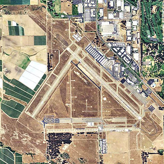
Yuma International Airport is a joint use airport with civilian and military flight activity operated in conjunction with the U.S. Marine Corps via the Marine Corps Air Station Yuma. The airfield is located 3.5 miles south of the central business district of Yuma, a city in Yuma County, Arizona, United States, and 150 miles east of San Diego International Airport. It is mostly used for military aviation, but is also served by one commercial airline and one aeromedical Medevac company as well as being used for general aviation activities.

<span class="mw-page-title-main">San Angelo Regional Airport</span> Airport in San Angelo, Texas

San Angelo Regional Airport, serves San Angelo in Tom Green County, Texas, United States. The airport covers 1,517 acres (614 ha) and has three runways. It has free parking.

<span class="mw-page-title-main">Glacier Park International Airport</span> Airport in Montana, United States

Glacier Park International Airport is in Flathead County, Montana, United States, six miles northeast of Kalispell. The airport is owned and operated by the Flathead Municipal Airport Authority, a public agency created by the county in 1974.

<span class="mw-page-title-main">Grand Canyon National Park Airport</span> Airport in Coconino County, Arizona

Grand Canyon National Park Airport is a state-owned public-use airport located in Tusayan, CDP in unincorporated Coconino County, Arizona, United States. It is near Grand Canyon National Park, 1 mile from the South Rim entrance of the Grand Canyon. The airport is primarily used for scenic tours and charter flights.

<span class="mw-page-title-main">Bonanza Air Lines</span> Defunct United States airline

Bonanza Air Lines was an airline in the Western United States from 1945 until it merged with two other local service airlines to form Air West in 1968. Its headquarters was initially Las Vegas, Nevada, and moved to Phoenix, Arizona in 1966.

<span class="mw-page-title-main">Borrego Valley Airport</span> Airport in California, USA

Borrego Valley Airport is a county-owned public airport three miles east of Borrego Springs, in San Diego County, California, United States.

Imperial Airlines was a United States commuter airline that operated from 1964 to 1986. Imperial served a number of cities in Southern California and for a brief period several cities in Arizona.

<span class="mw-page-title-main">Sun Aire Lines</span>

Sun Aire Lines was a United States commuter airline that operated from 1968 to 1985. Sun Aire served a number of cities in Southern California and Arizona.

Cochise Airlines was a commuter airline which was founded in 1971 in Tucson, Arizona. It operated until the early 1980s. Cochise linked small cities in Arizona with Phoenix, Arizona and Tucson, Arizona and also served southern California and New Mexico at one point.

References

  1. 1 2 3 4 5 FAA Airport Form 5010 for IPL PDF . Federal Aviation Administration. effective April 21, 2022.
  2. "IATA Airport Code Search (IPL: El Centro / Imperial County)". International Air Transport Association . Retrieved June 6, 2014.
  3. "Imperial city, California [ permanent dead link ]." U.S. Census Bureau. Retrieved on September 26, 2009.
  4. "Pilot Who Left Note in Airplane Hunted." Los Angeles Times . May 19, 1970. 3. Retrieved on September 26, 2009.
  5. "2011–2015 NPIAS Report, Appendix A" (PDF). National Plan of Integrated Airport Systems. Federal Aviation Administration. October 4, 2010. Archived from the original (PDF, 2.03 MB) on September 27, 2012.
  6. 1 2 http://www.timetableimages.com, April 1, 1948 Western Airlines system timetable
  7. 1 2 3 http://www.timetableimages.com, March 1, 1953 Bonanza Air Lines system timetable
  8. http://www.timetablemages.com%5B%5D, March 1, 1953 Bonanza Air Lines system timetable
  9. http://www.timetableimages.com, Aug. 16, 1963 Bonanza Air Lines system timetable
  10. http://www.timetableimages.com, March 1, 1964 Bonanza Air Lines system timetable
  11. http://www.timetableimages.com, July 1, 1968 Air West system timetable
  12. 1 2 Nov. 15, 1970 Official Airline Guide (OAG), El Centro flight schedules
  13. http://www.departedflights.com, July 1, 1972 Hughes Airwest system timetable
  14. http://www.departedflight.com Archived 2017-10-24 at the Wayback Machine , Sept. 1, 1980 Hughes Airwest system timetable
  15. http://www.departedflights.com, Official Airline Guide (OAG) editions: Nov. 15, 1969, Nov. 15, 1979; April 1, 1981, Feb. 15, 1985; Dec. 15, 1989; Oct. 1, 1991; April 2, 1995 and July 1, 1999
  16. Feb. 1, 2007 Official Airline Guide (OAG), Worldwide edition
  17. 1 2 https://iflysouthern.com/
  18. 1 2 "El Centro, CA: Imperial County (IPL)". Bureau of Transportation Statistics (BTS), Research and Innovative Technology Administration (RITA), U.S. Department of Transportation. January 2022. Retrieved November 12, 2022.

Other sources