
This is an alphabetical index of all articles related to the continent of Antarctica.
This is an alphabetical index of all articles related to the continent of Antarctica.
Polar route includes flights over the Arctic and Antarctic.
The history of Antarctica emerges from early Western theories of a vast continent, known as Terra Australis, believed to exist in the far south of the globe. The term Antarctic, referring to the opposite of the Arctic Circle, was coined by Marinus of Tyre in the 2nd century AD.

The Ross Sea is a deep bay of the Southern Ocean in Antarctica, between Victoria Land and Marie Byrd Land and within the Ross Embayment, and is the southernmost sea on Earth. It derives its name from the British explorer James Clark Ross who visited this area in 1841. To the west of the sea lies Ross Island and Victoria Land, to the east Roosevelt Island and Edward VII Peninsula in Marie Byrd Land, while the southernmost part is covered by the Ross Ice Shelf, and is about 200 miles (320 km) from the South Pole. Its boundaries and area have been defined by the New Zealand National Institute of Water and Atmospheric Research as having an area of 637,000 square kilometres (246,000 sq mi).

Ross Island is an island in Antarctica lying on the east side of McMurdo Sound and extending 43 nautical miles from Cape Bird on the north to Cape Armitage on the south, and a like distance from Cape Royds on the west to Cape Crozier on the east. The island is entirely volcanic. Mount Erebus, 3,795 metres (12,451 ft), near the center, is an active volcano. Mount Terror, 3,230 metres (10,600 ft), about 20 nautical miles eastward, is an extinct volcano. Mount Bird rises to 1,765 metres (5,791 ft) just south of Cape Bird. Ross Island lies within the boundary of Ross Dependency, an area of Antarctica claimed by New Zealand.

The Ross Ice Shelf is the largest ice shelf of Antarctica. It is several hundred metres thick. The nearly vertical ice front to the open sea is more than 600 kilometres (370 mi) long, and between 15 and 50 metres high above the water surface. Ninety percent of the floating ice, however, is below the water surface.
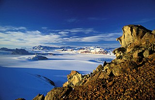
The Transantarctic Mountains comprise a mountain range of uplifted rock in Antarctica which extends, with some interruptions, across the continent from Cape Adare in northern Victoria Land to Coats Land. These mountains divide East Antarctica and West Antarctica. They include a number of separately named mountain groups, which are often again subdivided into smaller ranges.

The McMurdo Sound is a sound in Antarctica, known as the southernmost passable body of water in the world, located approximately 1,300 kilometres (810 mi) from the South Pole.
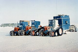
The Commonwealth Trans-Antarctic Expedition (CTAE) of 1955–1958 was a Commonwealth-sponsored expedition that successfully completed the first overland crossing of Antarctica, via the South Pole. It was the first expedition to reach the South Pole overland for 46 years, preceded only by Amundsen's expedition and Scott's expedition in 1911 and 1912.

Marie Byrd Land (MBL) is an unclaimed region of Antarctica. With an area of 1,610,000 km2 (620,000 sq mi), it is the largest unclaimed territory on Earth. It was named after the wife of American naval officer Richard E. Byrd, who explored the region in the early 20th century.

The Bay of Whales was a natural ice harbour, or iceport, indenting the front of the Ross Ice Shelf just north of Roosevelt Island, Antarctica, at the southernmost point of the world's ocean. While the Ross Sea stretches considerably further south – encompassing the Gould Coast, located around 320 kilometres from the South Pole – the majority of this expanse is covered by the Ross Ice Shelf, rather than open sea.

The Imperial Trans-Antarctic Expedition of 1914–1917 is considered to be the last major expedition of the Heroic Age of Antarctic Exploration. Conceived by Sir Ernest Shackleton, the expedition was an attempt to make the first land crossing of the Antarctic continent. After Roald Amundsen's South Pole expedition in 1911, this crossing remained, in Shackleton's words, the "one great main object of Antarctic journeyings". Shackleton's expedition failed to accomplish this objective but became recognized instead as an epic feat of endurance.

King Edward VII Land or King Edward VII Peninsula is a large, ice-covered peninsula which forms the northwestern extremity of Marie Byrd Land in Antarctica. The peninsula projects into the Ross Sea between Sulzberger Bay and the northeast corner of the Ross Ice Shelf, and forms part of the Ross Dependency. Edward VII Peninsula is defined by the Ross Ice Shelf on the southwest, Okuma Bay on the west, and to the east by Sulzberger Bay and the Saunders Coast, all essentially on the Ross Sea / Southern Ocean in Antarctica. The northwest extremity of the peninsula is Cape Colbeck. Edward VII Peninsula is located at 77°40′S155°00′W.

Scott's Hut is a building located on the north shore of Cape Evans on Ross Island in Antarctica. It was erected in 1911 by the British Antarctic Expedition of 1910–1913 led by Robert Falcon Scott.

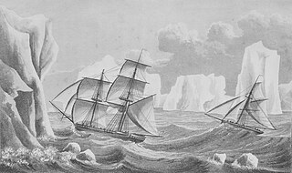
The DiscoveryExpedition of 1901–1904, known officially as the British National Antarctic Expedition, was the first official British exploration of the Antarctic regions since the voyage of James Clark Ross sixty years earlier (1839–1843). Organized on a large scale under a joint committee of the Royal Society and the Royal Geographical Society (RGS), the new expedition carried out scientific research and geographical exploration in what was then largely an untouched continent. It launched the Antarctic careers of many who would become leading figures in the Heroic Age of Antarctic Exploration, including Robert Falcon Scott who led the expedition, Ernest Shackleton, Edward Wilson, Frank Wild, Tom Crean and William Lashly.
Minna Bluff is a narrow, bold peninsula, 25 nautical miles long and 3 nautical miles wide, projecting southeast from Mount Discovery into the Ross Ice Shelf, Antarctica. It was discovered by the British National Antarctic Expedition (1901-04) which named it for Minna, the wife of Sir Clements Markham, the "father" of the expedition. It culminates in a south-pointing hook feature, and is the subject of research into Antarctic cryosphere history, funded by the National Science Foundation, Office of Polar Programs.

Commander Joseph Russell Stenhouse, DSO, OBE, DSC, RD, RNR (1887–1941) was a Scottish-born seaman, Royal Navy Officer and Antarctic navigator, who commanded the expedition vessel SY Aurora during her 283-day drift in the ice while on service with the Ross Sea Party component of Sir Ernest Shackleton's Imperial Trans-Antarctic Expedition in 1914–17. After Aurora's escape from the ice he brought her safely to New Zealand, but was thereafter replaced as the vessel's commander. He later served with distinction in the Royal Navy during both World Wars.

Farthest South refers to the most southerly latitude reached by explorers before the first successful expedition to the South Pole in 1911.

Mount Hope is a dome-shaped hill, rising to approximately 835 metres (2,740 ft), situated at the foot of the Beardmore Glacier, Ross Ice Shelf, Antarctica at 83°45′S171°00′E.

This article is a list of English-language nonfiction books which have been described by reliable sources as in some way directly relating to the subject of Antarctica, its history, geography, people, etc.
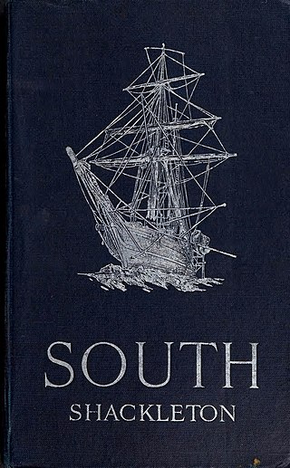
South is a book by Ernest Shackleton describing the second expedition to Antarctica led by him, the Imperial Trans-Antarctic Expedition of 1914 to 1917. It was published in London by William Heinemann in 1919.
