Related Research Articles

The Calumet River is a system of heavily industrialized rivers and canals in the region between the south side of Chicago, Illinois, and the city of Gary, Indiana. Historically, the Little Calumet River and the Grand Calumet River were one, the former flowing west from Indiana into Illinois, then turning back east to its mouth at Lake Michigan at Marquette Park in Gary.

Indiana Dunes National Park is a United States national park located in northwestern Indiana managed by the National Park Service. It was authorized by Congress in 1966 as the Indiana Dunes National Lakeshore and was redesignated as the nation's 61st national park on February 15, 2019. The park runs for about 20 miles (32 km) along the southern shore of Lake Michigan; it covers 15,349 acres (6,212 ha), including the 2,182-acre (883 ha) Indiana Dunes State Park and Hoosier Prairie State Nature Preserve, which are owned and managed by the Indiana Department of Natural Resources. The visitor center is in Porter, Indiana. Located in the park are sand dune, wetland, prairie, river, and forest ecosystems.

The Tinley Moraine is a moraine around the Lake Michigan basin in North America. It was formed during the Wisconsin Glaciation and is younger than the higher and wider terminal moraine called the Valparaiso Moraine, which is located farther from the lake than the Tinley Moraine. Compared to the Valparaiso Moraine, the Tinley Moraine is much narrower and occupies a similar swath, about 6 miles (10 km) closer to Lake Michigan, and passes through the communities of Flossmoor, Western Springs, and Arlington Heights. The moraine probably was named after the village of Tinley Park, a village southwest of Chicago that lies on the moraine.

Miller Beach is a neighborhood of Gary, Indiana on the southernmost shore of Lake Michigan. First settled in 1851, Miller Beach was originally an independent town. However, the "Town of Miller" was eventually annexed by the then flourishing city of Gary in 1918. Located in the northeastern corner of Lake County, Indiana, the former town is now known as "The Miller Beach Community." Miller Beach borders Lake Michigan to the north, Porter County to the east, and is largely surrounded by protected lands, including Indiana Dunes National Park. Miller Beach is also the closest beach/resort community to Chicago, and has been a popular vacation spot since the early 20th century. As of the 2000 US census, it had a population of 9,900.

The Calumet Shoreline is an ancient shoreline of Lake Michigan located in the Lake Michigan Basin. It can be clearly seen as a sand ridge along Ridge Road south of Chicago. Closer to the lake from the Calumet Shoreline, there are the Tolleston shorelines and farther from the lake are the Glenwood Shoreline, the Tinley Moraine, and the Valparaiso Moraine. The shoreline is named after the Calumet Region of Northern Indiana.

The Glenwood Shoreline is an ancient shoreline of the precursor to Lake Michigan, Lake Chicago. It is named after the town of Glenwood, Illinois. The shoreline was formed when the lake was higher during the last Ice Age, while ice blocked the Straits of Mackinac. After the straits were freed, the lake receded and left behind a sand ridge at an elevation of about 640 feet (200 m) where the shore resided. This ridge can be seen clearly in Glenwood, Illinois, Dyer, Indiana, and Schererville, Indiana, all south of Chicago.

Marquette Park, originally called Lake Front Park, is a municipal park completely surrounded by Indiana Dunes National Park. Its primary elements include 1.4 miles (2.2 km) of white sand Lake Michigan beaches, inland ponds, impressively high sand dunes, wetlands, a lagoon, and indigenous oak savanna. The park is located within the Miller Beach community. Miller Beach was once an independent municipality. However, in 1918 shortly before the establishment of Marquette Park, the Town of Miller was forcibly annexed into the municipal boundaries of Gary, Indiana. The park includes the Octave Chanute museum, registered as a National Landmark of Soaring.
Tremont, Indiana, is a ghost town formerly located in what is now the Indiana Dunes State Park and Indiana Dunes National Park in Westchester Township in northern Porter County, Indiana. It was first established in 1833. It was located at the intersection of U.S. Highway 12 and County Road 100 East, near Indiana 49. The community is named for three massive sand dunes that are now contained within the State park. They are Mount Tom, Mount Holden 170 feet (52 m), and Mount Green 160 feet (49 m).

The Indiana Dunes comprise ten different habitats. Each provides for a unique combination of plants and animals. The range of the Indiana Dunes varies depending your source. The Indiana Lake Michigan Coastal Program uses the river drainage systems along the shoreline. This expands the area from the areas of lakeshore southward to the edges of the Valparaiso Moraine. This entire region has been dune landscapes since over 114,000 years before present (YBP). Traditionally, the Indiana Dunes area thought of as a narrow area along the shores of Lake Michigan, including the areas of Marquette Park in Gary, Indiana (1920), Indiana Dunes State Park (1926) and Indiana Dunes National Park,. The identified ten habitats can be found in these parks, where they have been preserved, but are also visible throughout the three counties of Northwest Indiana.

Baillytown is a former community in northern Porter County, Indiana, near the present-day communities of Porter and Burns Harbor. Although the town platted as the Town of Bailly was never built, the Baillytown name was used for many years to refer to the area around the original Joseph Bailly trading post. The name continues today as the name of a subdivision, constructed in the 1990s, in the town of Porter.
The East Arm Little Calumet River, also known as the Little Calumet River East Branch, is a 22.1-mile-long (35.6 km) portion of the Little Calumet River that begins just east of Holmesville, Indiana in New Durham Township in LaPorte County and flows west to Porter County and the Port of Indiana-Burns Waterway.

Aetna is a neighborhood in northeastern Gary, Indiana, south of Miller Beach and east of Interstate 65. As of 2000, the neighborhood had a population of 4,942, which was 83% black and 11% white.

Miller Woods is the far western unit of Indiana Dunes National Park in the lakefront community of Miller Beach, Indiana. Miller Woods is home to the federally endangered Karner Blue butterfly and the federally threatened Pitcher's thistle. Miller Woods is also the only part of the National Park that also adjoins the Grand Calumet River.

Hartsdale was a town in St. John Township, Lake County, Indiana, United States. It was part of the Chicago metropolitan area. Hartsdale was annexed by Schererville, Indiana, in 1911.
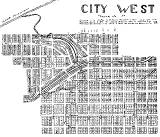
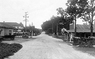
City West was a village in Porter County, Indiana, USA, located on the shore of Lake Michigan approximately 10 miles west of Michigan City, Indiana. It was situated near the mouth of Fort Creek, now known as Dunes Creek, which empties into Lake Michigan near the Indiana Dunes State Park swimming beach. It was located near the former site of Petit Fort.

The Grand Calumet River is a 13.0-mile-long (20.9 km) river that flows primarily into Lake Michigan. Originating in Miller Beach in Gary, it flows through the cities of Gary, East Chicago and Hammond, as well as Calumet City and Burnham on the Illinois side. The majority of the river's flow drains into Lake Michigan via the Indiana Harbor and Ship Canal, sending about 1,500 cubic feet (42 m3) per second of water into the lake. A smaller part of the flow, at the river's western end, enters the Calumet River and ultimately drains into the Illinois and ultimately the Mississippi River.
The Calumet Feeder Canal was a short canal in Illinois, operated during the mid-19th century. It connected the Little Calumet River to the Illinois and Michigan (I&M) Canal, and ran from Blue Island, where the Little Calumet made a hairpin turn toward Lake Michigan, to meet the I&M canal at Sag Bridge. The canal was completed in 1849, and covered 16.75 miles (26.96 km). It was one of four feeder canals built for the I&M, the others being the Du Page Feeder, Fox River Feeder and Kankakee Feeder.

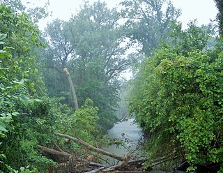
Dunes Creek is a northwards-flowing 4.3-mile-long (6.9 km) stream which drains the Great Marsh of Indiana Dunes State Park and Indiana Dunes National Park in Porter County, Indiana, United States. Dunes Creek passes through the coastal sand dunes to empty into Lake Michigan.
Ridge and swale, or in dunal areas dune and swale, is a landform consisting of regular, parallel ridges alternating with marshy depressions. Ridge-and-swale landscapes are most commonly formed by the gradual movement of a beach, for example as a result of gradually fluctuating water levels, or the shifting meanders of a river. In the river context, ridge-and-swale landscapes are commonly formed by scroll bars. They are also found along ocean coasts, for example on the Outer Banks of North Carolina.
References
- 1 2 3 Schoon 2003, p. 175.
- ↑ Schoon 2003, p. 79.
- 1 2 Brennan, George A. (1923). The Wonders of the Dunes. p. 101.
- 1 2 Simon & Ammeson 2012, p. 7.
Municipalities and communities of Lake County, Indiana, United States | ||
|---|---|---|
| Cities |  | |
| Towns | ||
| Townships | ||
| CDPs | ||
| Other unincorporated communities | ||
| Ghost town | ||
| Footnotes | ‡This populated place also has portions in an adjacent county or counties. | |