Inner London

Last updated
Inner London
Inner London (statutory).svg
Statutory definition
Inner London (statistical).svg
Statistical definition
Sovereign state United Kingdom
Country England
Region London
Administrative area Greater London
Area
  Total123 sq mi (319 km2)
Population
 (2021 Census)
  Total3,404,300
  Density28,000/sq mi (11,000/km2)
NUTS UKI1

Inner London is the name for the group of London boroughs that form the interior part of Greater London and are surrounded by Outer London. With its origins in the bills of mortality, it became fixed as an area for statistics in 1847 and was used as an area of local government from 1855 to 1965 principally as the County of London or earlier as the Metropolitan Board of Works Area (metropolis). It now has two common definitions. The first is the statutory definition delineated in the London Government Act 1963, coming into force on 1 April 1965, comprising twelve Inner London boroughs and almost identical to the County of London that was abolished at the same time. [1] The second is the definition used by the Office for National Statistics comprising eleven of the statutory Inner London boroughs and two of the statutory Outer London boroughs, as well as the City of London. [2]

Contents

Inner London is smaller than Outer London both in terms of population and area, but the population density is more than double that of Outer London. Inner London is officially the wealthiest area in Europe with the most expensive street in Europe: GDP per capita is more than €80,000 [3] while the UK GDP per capita is around €27,000. [3]

History

Background

The area that is now Inner London was defined by the Registrar General as a collection of parishes called "London" and appeared in the 1851 Census. At the time the metropolitan area—commonly called the Metropolis—had its origins in the area of the Bills of mortality that had expanded from the tiny City of London into three surrounding counties[ which? ] over the previous several hundred years. The area become fixed in 1847 with the addition of Lewisham Poor Law Union and the parish of Hampstead. [4] In 1855 the Registrar General area, with the addition of Penge, was used to define the district of the Metropolitan Board of Works. [5] The Metropolis was also described as Inner London from the 1881 Census. [6] In 1889 this area became the County of London. The area was adjusted in 1900 when Penge was transferred to Kent and South Hornsey was gained from Middlesex.

London Government Act 1963

The "Inner London boroughs" were defined by the London Government Act 1963. [7] The Inner London boroughs occupied the same area as the County of London that was abolished as they were created. North Woolwich was an anomaly as it was part of the County of London, but became part of an Outer London borough.

The main difference between Inner and Outer London boroughs between 1965 and 1990 was that the councils of the inner boroughs were not local education authorities and there was a single Inner London Education Authority for the area, including the City of London. The inner borough councils became local education authorities on 1 April 1990.

The statutory definition is used as part of the grant settlement used to finance local government. [8]

The statutory Inner London boroughs are:

Newham London Borough Council argues that the municipality should be treated as part of Inner London for statutory purposes, as it is for statistical purposes (see below). [2] This would benefit the borough financially. Only the North Woolwich area of Newham fell within the former County of London, however, and the council's advocacy has not borne fruit.

The City of London was not designated as an Inner London borough, but the Corporation of London is usually classed as an inner London local authority. [9]

Statistics

Inner London population pyramid in 2021 Inner London population pyramid.svg
Inner London population pyramid in 2021

The Office for National Statistics and Eurostat define Inner London differently, explicitly including the City of London, adding Haringey and Newham, but excluding Greenwich. [10] The land area is 319 km2 (123 sq. miles) and the population at the 2021 Census was 3,404,300. [11]

Historical population
YearPopulation
1891
4,488,242
1901
4,859,558
1911
4,998,237
1921
4,972,870
1931
4,893,261
1939
4,364,457
1951
3,679,390
1961
3,492,879
1971
3,031,935
1981
2,550,100
1991
2,599,300
2001
2,859,400
2011
3,231,901
2021
3,404,300

Ethnicity

Ethnic GroupYear
1981 estimations [12] 1991 census [13] 2001 census [14] 2011 census [15] 2021 census [16]
Number%Number%Number%Number%Number%
White: Total2,062,83281.3%1,949,43074.2%1,816,60565.7%1,853,20957.3%1,813,91853.3%
White: British 1,396,75350.5%1,240,26638.4%1,130,88233.2%
White: Irish 93,16475,16566,808
White: Gypsy or Irish Traveller 3,0551,946
White: Roma19,347
White: Other 326,68811.8%534,72316.5%594,93517.5%
Asian or Asian British: Total161,8166.4%261,1599.9%294,36110.6%515,19315.9%586,43217.2%
Asian or Asian British: Indian 60,16677,99985,471109,933116,889
Asian or Asian British: Pakistani 2273030,82443,55959,89068,055
Asian or Asian British: Bangladeshi 35,0141.4%75,2752.9%128,3144.6%163,8385.1%216,8106.4%
Asian or Asian British: Chinese 193822935838,91865,98375,259
Asian or Asian British: Other Asian245241%477031.8%37,017115,549109,419
Black or Black British: Total273,51110.8%355,49313.5%454,45016.4%540,18116.7%550,14016.2%
Black or Black British: African 70,8692.8%114,330189,991276,5138.6%314,4969.2%
Black or Black British: Caribbean 161,4226.4%188,3337.2%228,6918.3%173,9595.4%167,4394.9%
Black or Black British: Other Black 41,22052,83035,76889,70968,205
Mixed or British Mixed: Total107,7063.9%189,7485.9%226,3206.6%
Mixed: White and Black Caribbean35,85556,90060,460
Mixed: White and Black African18,33532,20334,224
Mixed: White and Asian23,65142,11452,712
Mixed: Other Mixed29,86558,53178,924
Other: Total41,9321.7%61,4162.3%54,0742.2%133,5704.1%227,3356.7%
Other: Arab50,82158,171
Other: Any other ethnic group54,0742.2%82,749169,164
Non-White: Total477,26618.7%678,07025.8%910,59134.3%1,378,69242.7%1,590,22746.7%
Total2,540,098100%2,627,500100%2,766,114100%3,231,901100%3,404,145100%

Figures before 1971 have been reconstructed by the Office for National Statistics based on past censuses in order to fit the 2001 limits. Figures from 1981 onward are ONS midyear estimates (revised as of 2010). [17]

After centuries of increase, the population of Inner London reached its peak of 4,998,237 in 1911. The area's population from World War I began a steady decline as that of Outer London continued to increase. The census of 1951 showed the damage inflicted by the 1940s Blitz as the population of Greater London switched into decline which was reversed in Outer London with house building and territory expansion whereas in Inner London continued. The war damage and early 20th century slums had physical and psychological hence property price effects and focus on New Towns and suburban development reflected a drive among urban planners for greener, less dense settlements. Inner London reached a post-War nadir, a population not seen since the early 19th century in 1981 having 2,550,100 residents, after which an upward trend ensued and Inner London residents numbered 3,231,901 in 2011 1,766,336 short of the 1911 peak.

Strategic planning

For the purposes of the London Plan planning document produced by the Mayor of London, Inner London consists of the City of London, all the statutory Inner London boroughs, and Newham. [18]

Other definitions

London postal district shown (in red) against the Greater London boundary London Postal District.png
London postal district shown (in red) against the Greater London boundary

The area covered by the London postal district is sometimes referred to as 'Inner London'. [19] However it is not coterminous with other definitions of Inner London as its area is somewhat larger and covers 624 km2 (241 sq. miles). The southern part of the London Borough of Lewisham as well as a small part of the Royal Borough of Greenwich fall outside its boundaries whilst 44 of its 119 districts are in Outer London and its irregular shape stretches to the Greater London boundary at Mill Hill and Scratch Wood and beyond it at Sewardstone.

From 1990 to 2000 London used two separate telephone dialling codes with one code designated for Inner London, however the area covered by this code was widely different from all of the above definitions and most of Greater London is now covered by a single 020 dialling code.

Economy

There are approximately 200,000 businesses with around 2,000,000 employees in Inner London. 56% of all private sector jobs in Greater London are located in Inner London. [20] There is significant commuting of workers from Outer London and from outside Greater London. Much of the commercial activity is focused on Central London and Canary Wharf. 10% of public sector employment is focused on Westminster around the Government of the United Kingdom. [20]

Related Research Articles

<span class="mw-page-title-main">London boroughs</span> Administrative subdivisions of Greater London

The London boroughs are the 32 local authority districts that together with the City of London make up the administrative area of Greater London, England; each is governed by a London borough council. The present London boroughs were all created at the same time as Greater London on 1 April 1965 by the London Government Act 1963 and are a type of local government district. Twelve were designated as Inner London boroughs and twenty as Outer London boroughs. The City of London, the historic centre, is a separate ceremonial county and sui generis local government district that functions quite differently from a London borough. However, the two counties together comprise the administrative area of Greater London as well as the London Region, all of which is also governed by the Greater London Authority, under the Mayor of London.

<span class="mw-page-title-main">City of Westminster</span> City and borough in London, England

The City of Westminster is a London borough with city status in Greater London, England. It is the site of the United Kingdom's Houses of Parliament and much of the British government. It contains a large part of central London, including most of the West End, such as the major shopping areas around Oxford Street, Regent Street, Piccadilly and Bond Street, and the entertainment district of Soho. Many London landmarks are within the borough, including Buckingham Palace, Westminster Abbey, Whitehall, Westminster Cathedral, 10 Downing Street, and Trafalgar Square.

<span class="mw-page-title-main">Metropolitan Borough of Rochdale</span> Borough of Greater Manchester, England

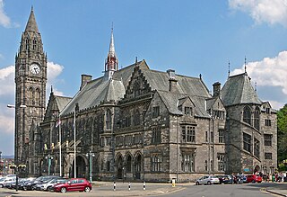
The Metropolitan Borough of Rochdale is a metropolitan borough of Greater Manchester in England. Its largest town is Rochdale and the wider borough covers other outlying towns and villages, including Middleton, Heywood, Milnrow and Littleborough. It is the ninth-largest district by population in Greater Manchester with a population of 226,992 in 2022.

<span class="mw-page-title-main">London Borough of Islington</span> London borough in United Kingdom

The London Borough of Islington is a London borough which forms part of Inner London, England. Islington has an estimated population of 215,667. It was formed in 1965, under the London Government Act 1963, by the amalgamation of the metropolitan boroughs of Islington and Finsbury.

<span class="mw-page-title-main">London Borough of Hackney</span> London borough in United Kingdom

The London Borough of Hackney is a London borough in Inner London, England. The historical and administrative heart of Hackney is Mare Street, which lies 5 miles (8 km) north-east of Charing Cross. The borough is named after Hackney, its principal district. Southern and eastern parts of the borough are popularly regarded as being part of east London that spans some of the traditional East End of London with the northwest belonging to north London. Its population is estimated to be 281,120.

<span class="mw-page-title-main">London Borough of Southwark</span> London borough in United Kingdom

The London Borough of Southwark in South London forms part of Inner London and is connected by bridges across the River Thames to the City of London and London Borough of Tower Hamlets. It was created in 1965 when three smaller council areas amalgamated under the London Government Act 1963. All districts of the area are within the London postal district. It is governed by Southwark London Borough Council.

<span class="mw-page-title-main">London Borough of Ealing</span> London borough in United Kingdom

The London Borough of Ealing is a London borough in London, England. It comprises the districts of Acton, Ealing, Greenford, Hanwell, Northolt, Perivale and Southall. With a population of 367,100 inhabitants, it is the third most populous London borough.

<span class="mw-page-title-main">London Borough of Haringey</span> London borough in United Kingdom

The London Borough of Haringey is a London borough in north London, classified by some definitions as part of Inner London, and by others as part of Outer London. It was created in 1965 by the amalgamation of three former boroughs. It shares borders with six other London boroughs. Clockwise from the north, they are: Enfield, Waltham Forest, Hackney, Islington, Camden, and Barnet.

<span class="mw-page-title-main">London Borough of Brent</span> London borough in United Kingdom

Brent is a borough in north-west London, England. It is known for landmarks such as Wembley Stadium, the Swaminarayan Temple and the Kiln Theatre. It also contains the Welsh Harp reservoir and the Park Royal commercial estate. The local authority is Brent London Borough Council.

<span class="mw-page-title-main">London Borough of Redbridge</span> London borough in United Kingdom

The London Borough of Redbridge is a London borough established in 1965.

<span class="mw-page-title-main">London Borough of Lewisham</span> Borough of London

Lewisham is a London borough in south-east London, England. It forms part of Inner London. The principal settlement of the borough is Lewisham. The local authority is Lewisham London Borough Council, based in Catford. The Prime Meridian passes through Lewisham. Blackheath, Goldsmiths, University of London and Millwall F.C. are located within the borough.

<span class="mw-page-title-main">London Borough of Lambeth</span> London borough in United Kingdom

Lambeth is a London borough in South London, England, which forms part of Inner London. Its name was recorded in 1062 as Lambehitha and in 1255 as Lambeth. The geographical centre of London is at Frazier Street near Lambeth North tube station, though nearby Charing Cross on the other side of the Thames in the City of Westminster is traditionally considered the centre of London.

<span class="mw-page-title-main">London Borough of Newham</span> Inner Borough of London, England

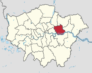
The London Borough of Newham is a London borough created in 1965 by the London Government Act 1963. It covers an area previously administered by the Essex county boroughs of West Ham and East Ham, authorities that were both abolished by the same act. The name Newham reflects its creation and combines the compass points of the old borough names. Situated in the Inner London part of East London, Newham has a population of 387,576, which is the fourth highest of the London boroughs and also makes it the 26th most populous district in England. The local authority is Newham London Borough Council.

<span class="mw-page-title-main">County of London</span> County of England between 1889 and 1965

The County of London was a county of England from 1889 to 1965, corresponding to the area known today as Inner London. It was created as part of the general introduction of elected county government in England, by way of the Local Government Act 1888. The Act created an administrative County of London, which included within its territory the City of London. However, the City of London and the County of London formed separate ceremonial counties for "non-administrative" purposes. The local authority for the county was the London County Council (LCC), which initially performed only a limited range of functions, but gained further powers during its 76-year existence. The LCC provided very few services within the City of London, where the ancient Corporation monopolised local governance. In 1900, the lower-tier civil parishes and district boards were replaced with 28 new metropolitan boroughs. The territory of the county was 74,903 acres (303.12 km2) in 1961. During its existence, there was a long-term decline in population as more residents moved into the outer suburbs; there were periodic reviews of the local government structures in the greater London area and several failed attempts to expand the boundaries of the county. In 1965, the London Government Act 1963 replaced the county with the much larger Greater London administrative area.

<span class="mw-page-title-main">Outer London</span> Outer boroughs of Greater London

Outer London is the name for the group of London boroughs that form a ring around Inner London. Together, the inner and outer boroughs form London, the capital city of the United Kingdom. The population at the 2021 Census was 5,395,500, which means over 60% of the population of Greater London lives in Outer London.

<span class="mw-page-title-main">Metropolitan Police District</span> Police area in Police area

The Metropolitan Police District (MPD) is the police area which is policed by the Metropolitan Police Service in London. It currently consists of the ceremonial county of Greater London, which excludes the City of London. The Metropolitan Police District was created by the Metropolitan Police Act 1829 as an ad hoc area of administration because the built-up area of London spread at the time into many parishes and counties without an established boundary. The district expanded as the built up area grew and stretched some distance into rural land. When county police forces were set up in England, those of Essex, Hertfordshire, Kent and Surrey did not cover the parts of the counties within the MPD, while Middlesex did not have a county force. Similarly, boroughs in the MPD that elsewhere would have been entitled to their own police force did not have them.

<span class="mw-page-title-main">Demographics of London</span>

The demography of London is analysed by the Office for National Statistics and data is produced for each of the Greater London wards, the City of London and the 32 London boroughs, the Inner London and Outer London statistical sub-regions, each of the Parliamentary constituencies in London, and for all of Greater London as a whole. Additionally, data is produced for the Greater London Urban Area. Statistical information is produced about the size and geographical breakdown of the population, the number of people entering and leaving country and the number of people in each demographic subgroup. The total population of London as of 2021 is 8,799,800.

<span class="mw-page-title-main">Demographics of Greater Manchester</span>

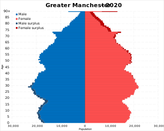
The demography of Greater Manchester is analysed by the Office for National Statistics and data is produced for each of its ten metropolitan boroughs, each of the Greater Manchester electoral wards, the NUTS3 statistical sub-regions, each of the Parliamentary constituencies in Greater Manchester, the 15 civil parishes in Greater Manchester, and for all of Greater Manchester as a whole; the latter of which had a population of 2,682,500 at the 2011 UK census. Additionally, data is produced for the Greater Manchester Urban Area. Statistical information is produced about the size and geographical breakdown of the population, the number of people entering and leaving country and the number of people in each demographic subgroup.

<span class="mw-page-title-main">Lewisham London Borough Council</span>

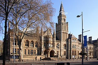
Lewisham London Borough Council, also known as Lewisham Council, is the local authority for the London Borough of Lewisham in Greater London, England. It is a London borough council, one of 32 in London. The council has been under Labour majority control since 2010. It has been led by a directly elected mayor since 2002. The council meets at Lewisham Town Hall in the Catford area of the borough.

<span class="mw-page-title-main">Greater London</span> Administrative area, ceremonial county and region of England

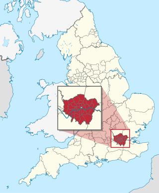
Greater London is the administrative area of London, England, which is coterminous with the London region. It contains 33 local government districts: the 32 London boroughs, which form a ceremonial county also called Greater London, and the City of London. The Greater London Authority is responsible for strategic local government across the region, and regular local government is the responsibility of the borough councils and the City of London Corporation. Greater London is bordered by the ceremonial counties of Hertfordshire to the north, Essex to the north-east, Kent to the south-east, Surrey to the south, and Berkshire and Buckinghamshire to the west.

References

  1. Saint, A., Politics and the people of London: the London County Council (1889–1965), (1989)
  2. 1 2 Newham London Borough Council Archived 2007-06-30 at the Wayback Machine – Positively Inner London
  3. 1 2 "Archived copy" (PDF). Archived from the original (PDF) on 2013-04-03. Retrieved 2013-03-25.{{cite web}}: CS1 maint: archived copy as title (link)
  4. "1861 Census: General Report". Vision of Britain. Archived from the original on 2016-08-29. Retrieved 2016-08-16.
  5. Davis, J., Reforming London: The London Government Problem, 1855–1900, (1988)
  6. "1881 Census: General Report". Vision of Britain. Archived from the original on 2016-08-29. Retrieved 2016-08-16.
  7. Office of Public Sector Information – London Government Act 1963 (c.33) (as amended) Archived 2008-05-30 at the Wayback Machine
  8. "Local authority lower tier boundaries – Greater London". Archived from the original on 2010-05-31.
  9. "List of inner/outer London boroughs". London Councils. Archived from the original on 22 January 2014. Retrieved 19 January 2014.
  10. "Inner London through time: Administrative History (post 1974)". A vision of Britain through time. Great Britain Historical GIS. Archived from the original on 2019-07-08. Retrieved 2009-11-20.
  11. "Population and household estimates, England and Wales: Census 2021". Office for National Statistics. Retrieved 8 July 2023.
  12. Ethnicity in the 1991 census: Vol 3 - Social geography and ethnicity in Britain, geographical spread, spatial concentration and internal migration. Internet Archive. London : HMSO. 1996. ISBN   978-0-11-691655-6.{{cite book}}: CS1 maint: others (link)
  13. Ethnicity in the 1991 census: Vol 3 - Social geography and ethnicity in Britain, geographical spread, spatial concentration and internal migration. Internet Archive. London : HMSO. 1996. ISBN   978-0-11-691655-6.{{cite book}}: CS1 maint: others (link)
  14. "Office of National Statistics; 2001 Census Key Statistics". webarchive.nationalarchives.gov.uk. Retrieved 2021-09-07.
  15. "2011 Census: Ethnic Group, local authorities in England and Wales". webarchive.nationalarchives.gov.uk. Retrieved 2021-12-15.
  16. "Ethnic group - Office for National Statistics". www.ons.gov.uk. Retrieved 2022-11-29.
  17. Neighbourhood Statistics Archived 3 February 2014 at the Wayback Machine Retrieved 12 July 2010
  18. Mayor of London. London Plan: Chapter 2 (PDF). Greater London Authority. Archived from the original (PDF) on 2015-09-06.
  19. HMSO, The Inner London Letter Post, (1980)
  20. 1 2 "Archived copy" (PDF). Archived from the original (PDF) on 2014-02-01. Retrieved 2014-01-20.{{cite web}}: CS1 maint: archived copy as title (link)

51°30′30″N0°07′31″W / 51.508411°N 0.125364°W / 51.508411; -0.125364