Royal Borough of Kensington and Chelsea

Last updated

Royal Borough of Kensington and Chelsea
London's Chelsea Bridge 5.jpg
The Albert Bridge from Battersea Park.jpg
Royal Hospital Chelsea - geograph.org.uk - 4588780.jpg
Natural History Museum 5.jpg
Kensington Palace2.jpg
Victoria and Albert Museum, London (2014) - 4.JPG
Coat of arms of the Royal Borough of Kensington and Chelsea.svg
Rb kensington and chelsea logo.svg
Kensington and Chelsea in Greater London.svg
Kensington and Chelsea shown within Greater London
Sovereign state United Kingdom
Constituent country England
Region London
Ceremonial county Greater London
Created1 April 1965
Admin HQ Holland Street
Government
  Type London borough council
  Body Kensington and Chelsea London Borough Council
  London Assembly James Small-Edwards (Labour) AM for West Central
   MPs
Area
  Total4.68 sq mi (12.13 km2)
  Rank295th (of 296)
Population
 (2022)
  Total146,154
  Rank152nd (of 296)
  Density31,000/sq mi (12,000/km2)
Time zone UTC (GMT)
  Summer (DST) UTC+1 (BST)
Postcodes
NW, SW, W
Area code 020
ISO 3166 code GB-KEC
ONS code 00AW
GSS code E09000020
Police Metropolitan Police
Website www.rbkc.gov.uk

The Royal Borough of Kensington and Chelsea (often known by its acronym as RBKC) is an Inner London borough with royal status. It is the smallest borough in London and the second smallest district in England; it is one of the most densely populated administrative regions in the United Kingdom. It includes affluent areas such as Notting Hill, Kensington, South Kensington, Chelsea, and Knightsbridge.

Contents

The borough is immediately west of the City of Westminster and east of the London Borough of Hammersmith and Fulham. It contains major museums and universities in Albertopolis, department stores such as Harrods, Peter Jones and Harvey Nichols, and embassies in Belgravia, Knightsbridge and Kensington Gardens. The borough is home to the Notting Hill Carnival, Europe's largest, and contains many of the most expensive residential properties in the world, as well as Kensington Palace, a British royal residence.

The local authority is Kensington and Chelsea London Borough Council. Its motto, adapted from the opening words of Psalm 133, is Quam bonum in unum habitare, which translates roughly as 'How good it is to dwell in unity'. [1]

History

Chelsea and Kensington were both ancient parishes in the historic county of Middlesex. From 1856 the two parishes were in the area governed by the Metropolitan Board of Works, which was established to provide services across the metropolis of London. [2] In 1889 the Metropolitan Board of Works' area was made the County of London. From 1856 until 1900 the lower tier of local government within the metropolis comprised various parish vestries and district boards, with both Chelsea and Kensington being governed by their respective vestries. In 1900 the lower tier was reorganised into metropolitan boroughs, two of which were called Chelsea and Kensington, corresponding to the two parishes. [3] The borough of Kensington was given the honorific title of royal borough in 1901. [4]

The modern borough was created in 1965 under the London Government Act 1963, which reorganised 86 boroughs and urban districts into 32 London boroughs and also created the Greater London Council. It was a merger of the old metropolitan boroughs of Chelsea and Kensington, and it inherited Kensington's royal borough status. [5] The new borough was originally intended to be called only "Kensington", but after protests from thousands of Chelsea residents, the then Minister of Housing and Local Government, Sir Keith Joseph, announced on 2 January 1964 that the name of the new borough would be the Royal Borough of Kensington and Chelsea. [6]

Of its history the council states: "Despite the boroughs being separate originally, Kensington and Chelsea still retain their unique characters. Even the amalgamation of the two boroughs, unpopular as it was at the time, has been accepted. Today conservation combined with the adoption of sympathetic new architecture is seen as a key objective. In every corner of the borough signs of its history can be seen: from Grade 1 listed buildings Kensington Palace and the Royal Hospital, Chelsea to others recalled in street names such as Pottery Lane and Hippodrome Mews." [7]

In 200 years the area has been transformed from a "rural idyll" to a thriving part of the modern metropolis. Chelsea had originally been countryside upon which Thomas More built Beaufort House. He came to Chelsea in 1520 and built the house, which in his day had two courtyards laid out between the house and the river, and in the north of the site acres of gardens and orchards were planted. It was from here in 1535 that More was taken to the Tower and beheaded later that year. [8] This area of Cheyne Walk continued its historic significance; nearby Crosby Hall sits on the river near the Church of Thomas More, and what was once Thomas Carlyle's residence remains on Cheyne Row.

Kensington's royal borough status was granted in 1901 as it included of Kensington Palace, where Queen Victoria was born in 1819 and lived until her accession in 1837. Commissioned by King William III, Christopher Wren enlarged and rebuilt the original house in 1689, turning it into a fitting royal residence. With the King came many court officials, servants and followers. Kensington Square, until then a failing venture, became a popular residential area. The Palace was regularly used by reigning monarchs until 1760 and since then by members of the Royal family. [9] Kensington's royal borough status was inherited by the new borough.

In the 19th century the last emperor of the Sikh Empire, Maharaja Duleep Singh who was brought to England as a child following the Second Anglo-Sikh War, along with the Koh-i-noor diamond, lived in the borough at 53 Holland Park, while his mother Maharani Jind Kaur (wife of Maharaja Ranjit Singh) lived at the nearby Abingdon House till her death in 1846.

During the Second World War civilians suffered great hardship; there were some 800 deaths and 40,000 injuries. A huge army of civilian volunteers was raised, including Auxiliary Fire Service, Red Cross, Air Raid Wardens and Rescue Services. During the Blitz much damage was caused by explosive and incendiary bombs, especially along Chelsea's riverside. But worse was to come in 1944 with the arrival of the V2 rockets, or flying bombs. Among the buildings either destroyed or seriously damaged, usually with terrible loss of life, were Chelsea Old Church, Church of Our Most Holy Redeemer, Our Lady of Victories, St Mary Abbots, St Stephens Hospital, St Mary Abbots Hospital, Sloane Square tube station, World's End, the Royal Hospital and Holland House. [10]

Districts

Areas in the borough include:

Parks and open Spaces

Governance

Kensington Town Hall, completed in 1976 Kensington and Chelsea Town Hall 2005.jpg
Kensington Town Hall, completed in 1976

The local authority is Kensington and Chelsea Council, which is based at Kensington Town Hall on Horton Street.

Greater London representation

Since 2000, for elections to the London Assembly, the borough forms part of the West Central constituency.

UK Parliament

The borough is divided between two constituencies represented in the House of Commons of the Parliament of the United Kingdom:

At the 2005 General Election, the borough was divided differently:

Rifkind held the Kensington seat until the 2015 General Election when he stood down after becoming embroiled in a scandal, uncovered by a television investigation, over accepting money in return for access to influential British diplomats and politicians. [11]

Evolution of parliamentary constituencies in RBKC
From 1885 From Feb 1974 From 1997 From 2010
Kensington North Kensington Part of Regent's Park and Kensington North Kensington
Kensington South Kensington and Chelsea
Chelsea Part of Chelsea and Fulham

Demographics

Population pyramid of the Borough of Kensington and Chelsea in 2021 Kensington and Chelsea population pyramid.svg
Population pyramid of the Borough of Kensington and Chelsea in 2021
Population census
YearPop.±%
1801 22,088    
1811 31,085+40.7%
1821 43,296+39.3%
1831 55,865+29.0%
1841 46,807−16.2%
1851 69,379+48.2%
1861 128,828+85.7%
1871 188,277+46.1%
1881 247,725+31.6%
1891 258,015+4.2%
1901 250,267−3.0%
1911 242,884−3.0%
1921 243,589+0.3%
1931 244,297+0.3%
1941 233,377−4.5%
1951 223,144−4.4%
1961 205,598−7.9%
1971 189,571−7.8%
1981 125,892−33.6%
1991 145,171+15.3%
2001 158,922+9.5%
2011 158,649−0.2%
Note: [12]

At the 2011 census, the borough had a population of 158,649 who were 71 percent White, 10 percent Asian, 5 percent of multiple ethnic groups, 4 percent Black African and 3 percent Black Caribbean. It is the least populated of the 32 London boroughs. Due to its high French population it has long held the unofficial title of the 21st arrondissement of Paris. [13]

A typical mews in the Royal Borough of Kensington and Chelsea Typical Street In The Royal Borough Of Kensington And Chelsea In London.jpg
A typical mews in the Royal Borough of Kensington and Chelsea

In 2005, the borough had more of its land covered by domestic buildings than anywhere else in England at 19%, over half the national average. [14] It also had the fifth highest proportion of land covered by non-domestic buildings at 12 percent. [14]

As of 2010 statistics released by the Office for National Statistics showed that life expectancy at birth for females was 89.8 years in 2008–2010, the highest in the United Kingdom. Male life expectancy at birth for the same period was 85.1 years. [15] The figures in 1991–1993 were significantly lower: 73.0 years for males (ranking 301st in the nation) and 80.0 for females (ranking 129th). Further investigation indicates a 12-year gap in life expectancy between the affluent wards of Chelsea (Royal Hospital, Hans Town) and the most northerly wards of North Kensington (Golborne, Dalgarno), which have high levels of social housing and poverty.

The borough has a higher proportion (16.6 percent) of high earners (over £60,000 per year) than any other local government district in the country. [16] It has the highest proportion of workers in the financial sector and the lowest proportion working in the retail sector.

In December 2006 Sport England published a survey which showed that the borough's residents were the fourth most active in England in sports and other fitness activities. 27.9 percent of the population participate at least three times a week for 30 minutes. [17]

A 2017 study by Trust for London [18] and the New Policy Institute [19] found that Kensington & Chelsea has the greatest income inequality of any London Borough. Private rent for low earners was also found to be the least affordable in London. However, the borough's poverty rate of 28% is roughly in line with the London-wide average. [20]

Ethnicity

Ethnic Group1981 estimations [21] 1991 [22] 2001 [23] 2011 [24] 2021 [25]
Number%Number%Number%Number%Number%
White: Total105,97590.5%116,79184.4%124,92478.61%112,01770.61%91,39463.8%
White: British 79,59450.08%62,27139.25%46,88332.7%
White: Irish 5,1833.26%3,7152.34%2,8252.0%
White: Gypsy or Irish Traveller 1190.08%840.1%
White: Roma1,0490.7%
White: Other 40,14725.26%45,91228.94%40,55328.3%
Asian or Asian British: Total8,4916.1%10,3296.50%15,86110.00%17,02511.8%
Asian or Asian British: Indian 1,6583,2262.03%2,5771.62%3,2092.2%
Asian or Asian British: Pakistani 8301,2030.76%9110.57%1,2820.9%
Asian or Asian British: Bangladeshi 6691,1480.72%8360.53%1,4881.0%
Asian or Asian British: Chinese 1,5282,5921.63%3,9682.50%3,8392.7%
Asian or Asian British: Other Asian3,8062,1601.36%7,5694.77%7,2075.0%
Black or Black British: Total8,0825.8%11,0816.97%10,3336.51%11,2797.9%
Black or Black British: African 3,0706,0133.78%5,5363.49%6,9444.8%
Black or Black British: Caribbean 3,4614,1012.58%3,2572.05%3,2372.3%
Black or Black British: Other Black 1,5519670.61%1,5400.97%1,0980.8%
Mixed or British Mixed: Total6,5054.09%8,9865.66%9,5256.6%
Mixed: White and Black Caribbean1,2900.81%1,6951.07%1,7251.2%
Mixed: White and Black African1,0570.67%1,1480.72%1,2880.9%
Mixed: White and Asian1,8631.17%3,0211.90%3,0472.1%
Mixed: Other Mixed2,2951.44%3,1221.97%3,4652.4%
Other: Total5,0303.6%6,0803.83%11,4527.22%14,1509.9%
Other: Arab6,4554.07%6,3844.5%
Other: Any other ethnic group5,0303.6%4,9973.15%7,7665.4%
Ethnic minority: Total11,1619.5%21,60315.5%33,99521.39%46,63229.39%51,97936.2%
Total117,136100%138,394100%158,919100.00%158,649100.00%143,373100%

Transport

Underground

A London Underground train departing from Earl's Court station London Train Station.jpg
A London Underground train departing from Earl's Court station

The borough has 12 tube stations, on five of the 11 London Underground lines:

with stations at South Kensington, Gloucester Road, High Street Kensington, Earl's Court, Sloane Square, West Brompton, Notting Hill Gate, Holland Park, Latimer Road, Knightsbridge, Westbourne Park and Ladbroke Grove.

Crossrail

Chelsea (SW3, SW10 and partly SW1) has significantly less Underground access than Kensington, the only station within Chelsea being Sloane Square. There have for some time been long-term plans for a Chelsea-Hackney line, with a station in the King's Road near Chelsea Town Hall, and possibly another at Sloane Square. As of June 2019, the plans for Crossrail 2 materialising show the proposed route tunnelling through Chelsea and featuring the planned King's Road Chelsea station on the site of Dovehouse Green. The future of this station, being the only fully new station on the proposed line, remains ambiguous; initial scrapping of the station idea [26] have been decried by withstanding placement of the station on official Transport for London information on the route. [27]

A Crossrail station on the original Crossrail route, from Paddington to Reading, has been proposed and endorsed by the council. [28] This station would be located near the northern end of Ladbroke Grove, and would serve the areas of North Kensington and Kensal. The council supports this station concept as it would renew infrastructure and build regeneration benefits in the area.

National Rail and Overground

Paddington and Victoria are the nearest major railway termini; National Rail stations in the borough are Kensington (Olympia) and West Brompton (and partly Kensal Green), both served by London Overground and Southern.

Buses

Many London bus routes pass through the borough, most of them along King's Road, Fulham Road, Kensington High Street and Ladbroke Grove.

Cycling

Kensington and Chelsea council has been criticised for its lack of support for cycle lanes and active travel in general. In 2019 the council vetoed a flagship programme by Transport for London for safer walking and cycling in the borough. [29] In 2020 it scrapped a cycle lane along Kensington High Street just seven weeks after it was installed. [30]

Travel to work

In March 2011 the main forms of transport that residents used to travel to work were: underground, metro, light rail, tram, 23.6 percent of all residents aged 16–74; driving a car or van, 8.2 percent; on foot, 8.2 percent; bus, minibus or coach, 8.0 percent; work mainly at or from home, 7.0 percent; bicycle, 3.1 percent; train, 2.1 percent. [31]

Social housing and Grenfell tower fire

Grenfell Tower in the early morning of 14 June 2017. Grenfell Tower fire morning.jpg
Grenfell Tower in the early morning of 14 June 2017.

The RBKC is a major provider of social housing in the borough owning 9,459 properties. [32] Of these over 73 percent are tenanted, with the remainder being leasehold. [32] The management of this housing was devolved to the Kensington and Chelsea TMO (KCTMO), a tenant management organisation. Properties included Trellick Tower.

The 2017 Grenfell Tower fire, in which one public-housing tower of the estate Grenfell Tower was completely destroyed and 72 lives were lost, drew international attention to the borough. After widespread criticism of the borough council's response to the fire, [33] [34] responsibility for providing services to those affected by the fire was taken away from RBKC. [35] Prime Minister Theresa May previously branded the response to the tragedy "not good enough", with Whitehall civil servants drafted in as part of a beefed-up operation in the local area. Anna Stec who gave evidence as an expert witness to the Grenfell Tower Inquiry has urged the authorities to test rescue workers, nearby residents and survivors for carcinogenic chemicals following the fire. [36]

Religion

Religion in Royal Borough of Kensington and Chelsea (2018) [37]

   Christianity (48.9%)
   Islam (10.3%)
   Judaism (4.7%)
   Hinduism (1.7%)
   Buddhism (1.7%)
  Any other religion (6.0%)
   Non-religious (26.8%)

The following shows the religious identity of residents residing in Kensington and Chelsea according to the 2001, 2011 and the 2021 censuses.

Religion2001 [38] 2011 [39] 2021 [40]
Number%Number%Number%
Holds religious beliefs120,05275.5110,01169.393,45265.2
Christian 98,46662.086,00554.269,33548.4
Muslim 13,3648.415,81210.016,86511.8
Jewish 3,5502.23,3202.12,6811.9
Hindu 1,5941.01,3860.91,5841.1
Sikh 3250.22630.23190.2
Buddhist 1,8491.22,4471.51,6061.1
Other religion9040.67780.51,0640.7
No religion24,24015.332,66920.635,61024.8
Religion not stated14,6279.215,96910.114,31110.0
Total population158,919100.0158,649100.0143,373100.0

Places of worship

The borough has a number of notable churches, including:

It is home to a small Spanish and Portuguese synagogue, several mosques and the Sikh Central Gurudwara in Holland Park. There are two Armenian churches - Saint Sarkis Armenian Church and Church of Saint Yeghiche. Westminster Synagogue is also partially located in the borough.

Diplomatic missions

The borough's notable districts are home to numerous international diplomatic missions:

High Commissions

Embassies

The Science Museum Science Museum 20180227 120430 (49362558971).jpg
The Science Museum

Within the borough there are several of London's tourist attractions and landmarks:

Education

Main entrance of the Royal School of Mines, Imperial College London ImperialCollegeLondon.jpg
Main entrance of the Royal School of Mines, Imperial College London

Schools

The council's education department finances state schools. [41]

London's Poverty Profile - a 2017 study by Trust for London [18] and the New Policy Institute [19] - found that 75% of 19-year-olds in Kensington and Chelsea have at least a C in their GCSE English and Maths. This is the highest success rate in London. [20]

Independent preparatory schools

Further education

Universities

Public libraries

Kensington Central Library, London W8 Kensington Central Library 10.JPG
Kensington Central Library, London W8

Libraries include the Kensington Central Library, Chelsea Library, Kensal Library, Brompton Library, North Kensington Library and the Notting Hill Gate Library. [42]

International relations

Town twinning

The Royal Borough of Kensington and Chelsea is formally twinned with:

Freedom of the Borough

The following people and military units have received the Freedom of Royal Borough of Kensington and Chelsea.

Individuals

Military Units

See also

Related Research Articles

<span class="mw-page-title-main">Notting Hill</span> Area of London, England

Notting Hill is a district of West London, England, in the Royal Borough of Kensington and Chelsea. Notting Hill is known for being a cosmopolitan and multicultural neighbourhood, hosting the annual Notting Hill Carnival and the Portobello Road Market. From around 1870, Notting Hill had an association with artists.

<span class="mw-page-title-main">Chelsea, London</span> District in west London, England

Chelsea is an affluent area in West London, England, due south-west of Charing Cross by approximately 2.5 miles. It lies on the north bank of the River Thames and for postal purposes is part of the south-western postal area.

<span class="mw-page-title-main">Metropolitan Borough of Chelsea</span> Former borough of London

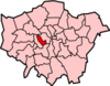
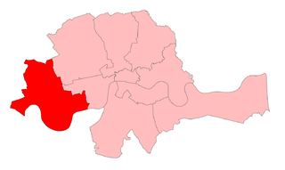
The Metropolitan Borough of Chelsea was a metropolitan borough of the County of London between 1900 and 1965. It was created by the London Government Act 1899 from most of the ancient parish of Chelsea. Following the London Government Act 1963, it was amalgamated with the Royal Borough of Kensington in 1965 to form the Royal Borough of Kensington and Chelsea.

<span class="mw-page-title-main">Metropolitan Borough of Kensington</span> Former borough of London

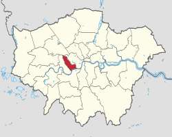
The Metropolitan Borough of Kensington was a metropolitan borough in the County of London from 1900 to 1965, which since 1901 was known as the Royal Borough of Kensington, following the death of Queen Victoria, in accordance with her wishes.

<span class="mw-page-title-main">Trellick Tower</span> Tower block in the Brutalist style in Kensal Town, London

Trellick Tower is a Grade II* listed tower block on the Cheltenham Estate in North Kensington, London. Opened in 1972, it was commissioned by the Greater London Council and designed in the Brutalist style by architect Ernő Goldfinger. The tower was planned to replace outdated social accommodation, and designed as an improvement on Goldfinger's earlier Balfron Tower in East London. It was the last major project he worked on, and featured various space-saving designs, along with a separate access tower containing a plant room.

<span class="mw-page-title-main">Ladbroke Grove</span> Human settlement in England

Ladbroke Grove is an area and a road in North Kensington in the Royal Borough of Kensington and Chelsea, passing through Kensal Green and Notting Hill, running north–south between Harrow Road and Holland Park Avenue.

<span class="mw-page-title-main">Counter's Creek</span> Culverted stream in west London

Counter's Creek, ending in Chelsea Creek, the lowest part of which still exists, was a stream that flowed from Kensal Green, by North Kensington and flowed south into the River Thames on the Tideway at Sands End, Fulham. Its remaining open watercourse is the quay of Chelsea Creek.

<span class="mw-page-title-main">Kensington (UK Parliament constituency)</span> British parliamentary constituency

Kensington is a former constituency in Greater London which first existed between 1974 and 1997 and was recreated in 2010. Since 2019, it has been represented in the House of Commons of the UK Parliament by Felicity Buchan of the Conservative Party. On 29 November 2023, it was replaced by the Kensington and Bayswater constituency, and will be first contested at the next general election.

<span class="mw-page-title-main">North Kensington</span> Neighbourhood of west London

North Kensington is an area of west London. It is north of Notting Hill and south of Kensal Green and in the Royal Borough of Kensington and Chelsea. The names North Kensington and Ladbroke Grove describe the same area.

<span class="mw-page-title-main">Brompton, London</span> Human settlement in England

Brompton, sometimes called Old Brompton, survives in name as a ward in the Royal Borough of Kensington and Chelsea in London. Until the latter half of the 19th century it was a scattered village made up mostly of market gardens in the county of Middlesex. It lay south-east of the village of Kensington, abutting the parish of St Margaret's, Westminster at the hamlet of Knightsbridge to the north-east, with Little Chelsea to the south. It was bisected by the Fulham Turnpike, the main road westward out of London to the ancient parish of Fulham and on to Putney and Surrey. It saw its first parish church, Holy Trinity Brompton, only in 1829. Today the village has been comprehensively eclipsed by segmentation due principally to railway development culminating in London Underground lines, and its imposition of station names, including Knightsbridge, South Kensington and Gloucester Road as the names of stops during accelerated urbanisation, but lacking any cogent reference to local history and usage or distinctions from neighbouring settlements.

<span class="mw-page-title-main">Chelsea (UK Parliament constituency)</span> Parliamentary constituency in the United Kingdom, 1885–1997

Chelsea was a borough constituency, represented in the House of Commons of the Parliament of the United Kingdom.

Ladbroke Grove is a proposed railway station in London, England on the Crossrail Route between Old Oak Common and Paddington. This is not part of the internal route and would be added at a later stage. Locals want the station to be called Portobello Central to serve the nearby Portobello Market. It was originally called Kensal.

<span class="mw-page-title-main">Kensington and Chelsea London Borough Council</span> Local authority in London

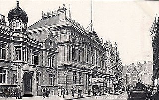
Kensington and Chelsea London Borough Council, also known as Kensington and Chelsea Council, is the local authority for the Royal Borough of Kensington and Chelsea in Greater London, England. It is a London borough council, one of 32 in London. The council has been under Conservative majority control since its creation in 1965. It is based at Kensington Town Hall.

<span class="mw-page-title-main">Golborne Road</span>

Golborne Road is a street in the Royal Borough of Kensington and Chelsea in London's Kensal Town. The road runs east from Portobello Road to Kensal Road.

<span class="mw-page-title-main">Tri-borough shared services</span>

Tri-borough is a project between three councils in west London, England to combine service provision. The councils are Westminster City Council, Hammersmith and Fulham London Borough Council and the Kensington and Chelsea London Borough Council. It launched in June 2011 and is due to come to an end in April 2018

The Parks Police Service was a small constabulary responsible for policing 87 parks and open spaces in the boroughs of Kensington and Chelsea and Hammersmith and Fulham. The police force was created through the merger of Hammersmith and Fulham Parks Constabulary and Royal Borough of Kensington and Chelsea Parks Police in 2013. In 2019, the respective councils of Hammersmith & Fulham and Kengsinton & Chelsea disaggregated their shared some of their services, including the Parks Police. As such, the Parks Police Service ceased to exist and the Royal Borough of Kensington and Chelsea Parks Police and the Hammersmith and Fulham Parks Constabulary came back into existence.

<span class="mw-page-title-main">Kensington Aldridge Academy</span> Academy in London, England

Kensington Aldridge Academy (KAA) is an 11–18 co-educational secondary school with academy status in the North Kensington area of the Royal Borough of Kensington and Chelsea, in London, England. KAA opened in September 2014, and was officially opened by Catherine, Duchess of Cambridge in January 2015. The Academy's sixth form opened in September 2016. The school specialisms are Entrepreneurship and Creative & Performing Arts.

Nicholas Paget-Brown is an English Conservative politician who was leader of the Kensington and Chelsea London Borough Council. He was first elected as a councillor for Hans Town on 8 May 1986. He became leader of the council on 23 May 2013. On 30 June 2017, he announced that he would step down as leader due to the council's response to the Grenfell Tower fire, and was replaced as leader by Conservative Elizabeth Campbell on 19 July 2017.

<span class="mw-page-title-main">2018 Kensington and Chelsea London Borough Council election</span>

The 2018 Kensington and Chelsea London Borough Council election took place on 3 May 2018 to elect members of Kensington and Chelsea London Borough Council in England. The election was held on the same day as other local elections in England. While Kensington and Chelsea is usually regarded as a Conservative stronghold, there was media speculation that Labour could win control of the council in the wake of the Grenfell Tower fire. However the Conservatives maintained control, losing just one Councillor, in St. Helen's Ward, winning 36 seats to Labour's 13.

<span class="mw-page-title-main">2022 Kensington and Chelsea London Borough Council election</span>

The 2022 Kensington and Chelsea London Borough Council election was held on 5 May 2022. All 50 members of Kensington and Chelsea London Borough Council were elected. The elections took place alongside local elections in the other London boroughs and elections to local authorities across the United Kingdom.

References

  1. "How council works: our Mayor: Coat of Arms". Royal Borough of Kensington and Chelsea. Retrieved 16 June 2017.
  2. Metropolis Management Act 1855 (18 & 19 Vict. c. 120)
  3. London Government Act 1899 (62 & 63 Vict. c. 14)
  4. "No. 27378". The London Gazette . 19 November 1901. p. 7472.
  5. Youngs, Frederic (1979). Guide to the Local Administrative Units of England. Vol. I: Southern England. London: Royal Historical Society. ISBN   0-901050-67-9.
  6. The Times, 3 January 1964:Chelsea Name Retained: New Decisions on Three Boroughs Linked 14 June 2018
  7. "The Modern Borough". Rbkc.gov.uk. Retrieved 6 May 2020.
  8. "Thomas More Comes to Chelsea". Rbkc.gov.uk. Retrieved 18 November 2018.
  9. "Royalty Comes to Kensington". Rbkc.gov.uk. Retrieved 18 November 2018.
  10. "The Boroughs at War". Rbkc.gov.uk. Retrieved 18 November 2018.
  11. "Malcolm Rifkind to stand down as an MP at the election after lobbying controversy". www.newstatesman.com. 24 February 2015. Retrieved 3 June 2015.
  12. "Kensington: Total Population". A Vision of Britain Through Time Great Britain Historical GIS Project. Retrieved 6 September 2011.
  13. Emma Rowley (12 May 2012). "High earners say au revoir to France" . The Daily Telegraph. Archived from the original on 12 January 2022. Retrieved 14 August 2012.
  14. 1 2 "Key Statistics: Dwellings; Quick Statistics: Population Density; Physical Environment: Land Use Survey 2005". Archived from the original on 11 February 2003. Retrieved 25 December 2021.
  15. Nadine Burham-Marshalleck (31 October 2011). "Kensington & Chelsea has UK's highest life expectancy - South West Londoner". Swlondoner.co.uk. Retrieved 16 June 2017.
  16. "Top ten fastest growing affluent areas". Business guardian.co.uk. Archived from the original on 25 May 2012. Retrieved 18 November 2018.
  17. "Active People Survey - headline results". Archived from the original on 20 January 2007. Retrieved 25 February 2010.
  18. 1 2 "London Poverty & Inequality - Trust For London". Trust for London.
  19. 1 2 "Home". www.npi.org.uk.
  20. 1 2 "London's Poverty Profile". Trust for London. Retrieved 19 July 2018.
  21. Equality, Commission for Racial (1985). "Ethnic minorities in Britain: statistical information on the pattern of settlement". Commission for Racial Equality: Table 2.2.
  22. "1991 census – theme tables". NOMIS. Archived from the original on 30 September 2018. Retrieved 20 January 2017.
  23. "KS006 - Ethnic group". NOMIS. Retrieved 30 January 2016.
  24. "Ethnic Group by measures". NOMIS. Retrieved 8 January 2016.
  25. "Ethnic group - Office for National Statistics". www.ons.gov.uk. Retrieved 29 November 2022.
  26. "Crossrail 2 route shake-up: Transport for London's (TfL) business case proposal scraps Kings Road Chelsea station and opts for Tooting over Balham | City A.M". 26 June 2017. Archived from the original on 27 March 2018. Retrieved 6 May 2020.
  27. "Route Map". CrossRail.
  28. "Kensal Portobello Crossrail Station | Royal Borough of Kensington and Chelsea". Rbkc.gov.uk. Retrieved 6 May 2020.
  29. "Kensington and Chelsea vetoes flagship road safety scheme". The Guardian. 14 June 2019. Retrieved 19 August 2022.
  30. "Kensington and Chelsea council criticised for scrapping cycle lane". The Guardian. 30 November 2020. Retrieved 19 August 2022.
  31. "2011 Census: QS701EW Method of travel to work, local authorities in England and Wales". Office for National Statistics. Retrieved 23 November 2013.
  32. 1 2 "Business Plan 2014-17" (PDF). kctmo.org.uk/ Kensington & Chelsea Tenant Management Organisation. Archived from the original (PDF) on 29 December 2016. Retrieved 18 June 2017.
  33. Horton, Helena (19 June 2017). "Anger as leader of Kensington Council appears to blame Grenfell residents for sprinklers not being installed" . telegraph.co.uk. Daily Telegraph. Archived from the original on 12 January 2022. Retrieved 19 June 2017.
  34. MacAskill, Ewen (19 June 2017). "Council sidelined in Grenfell Tower response as leader refuses to quit". Guardian.co.uk. The Guardian. Retrieved 19 June 2017.
  35. Flood, Rebecca (18 June 2017). "Specialist team set up after Grenfell Tower fire after response 'not good enough'". Express.co.uk. Daily Express. Retrieved 18 June 2017.
  36. "Grenfell soil tests 'reveal huge numbers of cancer forming toxins'" . Daily Telegraph. 13 October 2018. Archived from the original on 12 January 2022. Retrieved 7 December 2018.
  37. "Population by Religion, Borough". Office for National Statistics (ONS). Retrieved 2 June 2020.
  38. "KS007 - Religion - Nomis - 2001". www.nomisweb.co.uk. Retrieved 18 October 2022.
  39. "KS209EW (Religion) - Nomis - 2011". www.nomisweb.co.uk. Retrieved 18 October 2022.
  40. "Religion - 2021 census". Office of National Statistics. 29 November 2022. Archived from the original on 29 November 2022. Retrieved 16 December 2022.
  41. "Family and Children's Services". Royal Borough of Kensington and Chelsea. 14 June 2016. Retrieved 16 June 2017.
  42. http://www.rbkc.gov.uk/leisureandlibraries.aspx Royal Borough of Kensington and Chelsea. Retrieved 13 January 2009. [ permanent dead link ]
  43. "British towns twinned with French towns [via WaybackMachine.com]". Archant Community Media Ltd. Archived from the original on 5 July 2013. Retrieved 20 July 2013.
  44. "Appointment of Honorary Persons". Royal Borough of Kensington and Chelsea. Retrieved 30 November 2016.
  45. Archived at Ghostarchive and the Wayback Machine : British Pathé (13 April 2014). "Churchill Receives Freedom Of Kensington (1949)" . Retrieved 12 March 2017 via YouTube.
  46. "Civic Honours granted by the Royal Boroughs". www.steppingforwardlondon.org.
  47. "Royal Hospital Chelsea gains gift of a lifetime". www.rbkc.gov.uk.
  48. "Civic Honours – 41 (Princess Louise's Kensington) Squadron 38 Signal Regiment". Royal Borough of Kensington and Chelsea. Retrieved 13 July 2019.

51°30′N0°11′W / 51.50°N 0.19°W / 51.50; -0.19