The Royal Borough of Kensington and Chelsea is an Inner London borough with royal status. It is the smallest borough in London and the second smallest district in England; it is one of the most densely populated administrative regions in the United Kingdom. It includes affluent areas such as Notting Hill, Kensington, South Kensington, Chelsea, and Knightsbridge.

Knightsbridge is a residential and retail district in central London, south of Hyde Park. It is identified in the London Plan as one of two international retail centres in London, alongside the West End.

Chelsea is an affluent area in west London, England, due south-west of Charing Cross by approximately 2.5 miles. It lies on the north bank of the River Thames and for postal purposes is part of the south-western postal area.

Belgravia is an affluent district in Central London, covering parts of the areas of both the City of Westminster and the Royal Borough of Kensington and Chelsea.

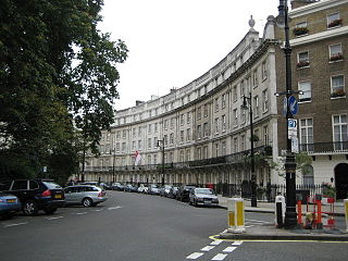
Sloane Square is a small hard-landscaped square on the boundaries of the central London districts of Belgravia and Chelsea, located 1.8 miles (2.9 km) southwest of Charing Cross, in the Royal Borough of Kensington and Chelsea. The area forms a boundary between the two largest aristocratic estates in London, the Grosvenor Estate and the Cadogan. The square was formerly known as 'Hans Town', laid out in 1771 to a plan of by Henry Holland Snr. and Henry Holland Jnr. Both the square and Hans Town were named after Sir Hans Sloane (1660–1753), an Anglo-Irish doctor who, jointly with his appointed trustees, owned the land at the time.

Sheikh Mohammed bin Rashid Al Maktoum is the vice president, prime minister, and minister of defence of the United Arab Emirates (UAE) as well as the ruler of Dubai. He is the third son of Sheikh Rashid bin Saeed Al Maktoum, former vice president of the UAE and ruler of Dubai. Mohammed succeeded his brother Maktoum as vice president and ruler following the latter's death in 2006.
Eaton Square is a rectangular, residential garden square in London's Belgravia district. It is the largest square in London. It is one of the three squares built by the landowning Grosvenor family when they developed the main part of Belgravia in the 19th century that are named after places in Cheshire — in this case Eaton Hall, the Grosvenor country house. It is larger but less grand than the central feature of the district, Belgrave Square, and both larger and grander than Chester Square. The first block was laid out by Thomas Cubitt from 1827. In 2016 it was named as the "Most Expensive Place to Buy Property in Britain", with a full terraced house costing on average £17 million — many of such town houses have been converted, within the same, protected structures, into upmarket apartments.

Hans Place is a garden square in the Knightsbridge district of the Royal Borough of Kensington and Chelsea, London, immediately south of Harrods in SW1. It is named after Sir Hans Sloane, 1st Baronet, PRS, physician and collector, notable for his bequest, which became the foundation of the British Museum.
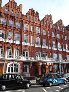
Pont Street is a fashionable street in the Royal Borough of Kensington and Chelsea, London, traversing the areas of Knightsbridge and Belgravia. The street is not far from the Knightsbridge department store Harrods to its north-west. The street crosses Sloane Street in the middle, with Beauchamp Place to the west and Cadogan Place, and Chesham Place, to the east, eventually leading to Belgrave Square. On the west side, Hans Place leads off the street to the north and Cadogan Square to the south.

Cadogan Group Limited and its subsidiaries, including Cadogan Estates Limited, are British property investment and management companies that are owned by the Cadogan family, one of the richest families in the United Kingdom, which also holds the titles of Earl Cadogan and Viscount Chelsea, the latter used as a courtesy title by the Earl's eldest son. The Cadogan Group is the main landlord in the west London districts of Chelsea and Knightsbridge, and it is now the second largest of the surviving aristocratic Freehold Estates in Central London, after the Duke of Westminster's Grosvenor Estate, to which it is adjacent, covering Mayfair and Belgravia.
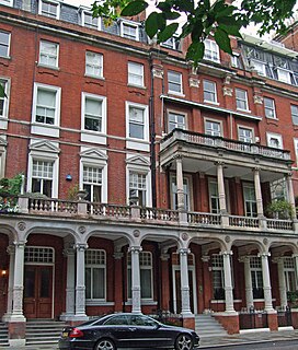
Cadogan Square is a residential square in Knightsbridge, London, that was named after Earl Cadogan. Whilst it is mainly a residential area, some of the properties are used for diplomatic and educational purposes.

Cadogan Place is a street in Belgravia, London. It is named after Earl Cadogan and runs parallel to the lower half of Sloane Street. It gives its name to the extensive Cadogan Place Gardens, private communal gardens maintained for Cadogan residents. It is owned by Cadogan Estates.

Lowndes Square is a residential garden square at the north-west end of Belgravia, London, SW1. It is formed of archetypal grand terraces of light stucco houses, cream or white. The length of the central rectangular garden is parallel with Sloane Street to the west; visible from the north-west corner is a corner of the Harvey Nichols store, beyond which is Knightsbridge tube station. Ecclesiastically, it remains in a northern projection of one of the parishes of Chelsea, save its east side, in the very small parish of St Paul, Knightsbridge, a division which is mirrored secularly by the boundaries of two London Boroughs.
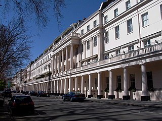
Wilton Crescent is a street in central London, comprising a sweeping elegant terrace of Georgian houses and the private communal gardens that the semi-circle looks out upon. The houses were built in the early 19th century and are now Grade II listed buildings. The street is the northern projection of Belgravia and is often taken to fall into the category of London's garden squares.

Draycott Hotel is a 5-star hotel in London, England.

Lennox Gardens is a garden square in the Knightsbridge district of London SW1X. It is one of the most exclusive garden squares in Knightsbridge, and houses on the square are valued at up to £40 million.
190-192 Sloane Street, also known as the Sekers Building, is a grade II listed building on Sloane Street, London at the junction with Harriet Street.
Charles William Stephens was a British architect. As architect to the Harrods department store in London from 1892 until his death, he was responsible for the store's famous Baroque-style façade on Brompton Road. His other designs include Harvey Nichols department store, the new Claridge's hotel, 54 Parkside, and the Park Lane Hotel, all in London.

Tedworth Square is a garden square in London's Chelsea district, SW3. The communal garden at the centre of the development is 0.1962 hectares in size.
Basil Street, originally known as North Street, is a street in London's Knightsbridge. It was laid out in the second half of the eighteenth century on land belonging to Lord Cadogan and runs between Sloane Street in the north and the junction of Walton Place and Hans Road in the south. It is joined on its east side by Pavilion Road and Rysbrack Street and crossed by Hans Crescent. Architecturally, it is notable for the design of its blocks of mansion flats. Fashion designer Charles Creed had his premises there after the war and in the 1960s, the first meetings that led to Monty Python's Flying Circus were held at a flat in the street.