Jarbidge, Nevada

Last updated

Jarbidge, Nevada
Jarbidge Nevada.jpg
USA Nevada location map.svg
Red pog.svg
Jarbidge, Nevada
Location within the state of Nevada
Usa edcp location map.svg
Red pog.svg
Jarbidge, Nevada
Jarbidge, Nevada (the United States)
Coordinates: 41°52′25″N115°25′55″W / 41.87361°N 115.43194°W / 41.87361; -115.43194
Country United States
State Nevada
County Elko
Elevation
6,218 ft (1,895 m)
ZIP code
89826 [1]
Area code 775
Website
Reference no.69

Jarbidge is an unincorporated community in Elko County, Nevada, United States. [2] Located at the bottom of the Jarbidge River's canyon near the north end of the Jarbidge Mountains, it lies within the Jarbidge Ranger District of the Humboldt-Toiyabe National Forest and is near the northwest edge of the Jarbidge Wilderness, approximately 10 miles (16 km) south of the IdahoNevada border. [3]

Contents

Jarbidge, along with the rest of Nevada except for the city of West Wendover, is legally in the Pacific Time Zone, [4] but, along with other Idaho border towns such as Jackpot, Mountain City and Owyhee, unofficially observes the Mountain Time Zone due to closer proximity to and greater connections with towns in southern Idaho. [5] Jarbidge is popular locally with hunters and campers with many campsites available in the area and high populations of elk. [6]

History

"Jarbidge" is a name derived from the Shoshone language meaning "devil". [7] Natives believed the nearby hills were haunted. [8]

Gold was discovered near Jarbidge in 1909, making it the site of one of the last gold rushes in the Old West and, incidentally, was the site of the last stagecoach robbery in 1916. Its population swelled to near 2000 in 1911 but afterward began a slow decline when the mining facilities were largely cannibalized for the war effort during World War I. Mining operations ceased completely in 1932. However, in 2013 permits for the removal of the gold were re-issued and the mine is reopening. [9]

Jazz musician Ralph Peña was born in Jarbidge in 1927.

Geography

Jarbidge, visible in the lower left of this photo, lies at the bottom of the Jarbidge River Canyon, which stretches 50 miles from the Jarbidge Mountains to the Bruneau River in Idaho 2013-08-15 17 05 09 View north-northwest down the Jarbidge River Canyon from about 8700 feet on the northwestern slopes of Jarbidge Peak.jpg
Jarbidge, visible in the lower left of this photo, lies at the bottom of the Jarbidge River Canyon, which stretches 50 miles from the Jarbidge Mountains to the Bruneau River in Idaho

Noted locally for its extreme remoteness, no paved roads exist within almost 20 miles (32 km) of Jarbidge. The community is usually and most easily accessed using a motor vehicle by way of Three Creek Road, which originates along U.S. Route 93 in Rogerson, Twin Falls County, Idaho; the final 18 miles (29 km) of this route are unimproved but usually open all year. From Elko, the easiest access is by proceeding 55 miles (89 km) north along Nevada State Route 225, then 27 miles (43 km) east along Elko County Road 746, the North Fork-Charleston Road (signed for Charleston and Jarbidge), and finally 22 miles (35 km) north along Elko County Road 748, the Charleston-Jarbidge Road. The latter two segments of this route are unimproved, at points, present serious road hazards, and receive no winter maintenance. They are often closed from as early as October or November to as late as June or July due to heavy snowfall. [10]

Climate

According to the Köppen Climate Classification system, Jarbidge has a warm-summer mediterranean continental climate, abbreviated "Dsb" on climate maps. The hottest temperature recorded in Jarbidge was 101 °F (38.3 °C) on July 14, 2002, while the coldest temperature recorded was −38 °F (−38.9 °C) on December 22, 1990. [11]

Climate data for Jarbidge 7 N, Nevada, 1991–2020 normals, 1996-2013 snowfall: 6050ft (1844m)
MonthJanFebMarAprMayJunJulAugSepOctNovDecYear
Record high °F (°C)63
(17)
61
(16)
77
(25)
80
(27)
89
(32)
97
(36)
100
(38)
100
(38)
92
(33)
85
(29)
73
(23)
61
(16)
100
(38)
Average high °F (°C)37.6
(3.1)
37.6
(3.1)
44.2
(6.8)
51.1
(10.6)
61.3
(16.3)
71.4
(21.9)
82.4
(28.0)
81.2
(27.3)
71.4
(21.9)
57.6
(14.2)
43.3
(6.3)
35.5
(1.9)
56.2
(13.5)
Daily mean °F (°C)27.7
(−2.4)
28.0
(−2.2)
33.8
(1.0)
39.1
(3.9)
47.7
(8.7)
55.5
(13.1)
64.9
(18.3)
63.6
(17.6)
54.7
(12.6)
43.5
(6.4)
32.7
(0.4)
25.9
(−3.4)
43.1
(6.2)
Average low °F (°C)17.7
(−7.9)
18.3
(−7.6)
23.3
(−4.8)
27.1
(−2.7)
34.0
(1.1)
39.6
(4.2)
47.5
(8.6)
46.0
(7.8)
38.1
(3.4)
29.4
(−1.4)
22.0
(−5.6)
16.4
(−8.7)
30.0
(−1.1)
Record low °F (°C)−14
(−26)
−18
(−28)
1
(−17)
7
(−14)
15
(−9)
23
(−5)
28
(−2)
27
(−3)
16
(−9)
−7
(−22)
−6
(−21)
−20
(−29)
−20
(−29)
Average precipitation inches (mm)1.43
(36)
1.10
(28)
1.87
(47)
2.51
(64)
2.30
(58)
1.40
(36)
0.55
(14)
0.34
(8.6)
0.92
(23)
1.13
(29)
1.49
(38)
1.29
(33)
16.33
(414.6)
Average snowfall inches (cm)15.2
(39)
13.2
(34)
16.8
(43)
12.8
(33)
3.7
(9.4)
0.4
(1.0)
0.0
(0.0)
0.0
(0.0)
0.8
(2.0)
3.8
(9.7)
9.2
(23)
14.0
(36)
89.9
(230.1)
Source 1: NOAA [12]
Source 2: XMACIS2 (snowfall & records) [13]
Climate data for Jarbidge, Nevada (Gibbs Ranch), 1991–2020 normals, extremes 1953–present
MonthJanFebMarAprMayJunJulAugSepOctNovDecYear
Record high °F (°C)60
(16)
66
(19)
75
(24)
83
(28)
90
(32)
95
(35)
101
(38)
99
(37)
96
(36)
87
(31)
72
(22)
59
(15)
101
(38)
Mean maximum °F (°C)47.3
(8.5)
51.0
(10.6)
62.8
(17.1)
72.9
(22.7)
80.0
(26.7)
88.3
(31.3)
94.4
(34.7)
92.7
(33.7)
87.7
(30.9)
77.8
(25.4)
63.8
(17.7)
50.4
(10.2)
95.1
(35.1)
Average high °F (°C)36.6
(2.6)
39.3
(4.1)
47.7
(8.7)
55.2
(12.9)
64.6
(18.1)
74.6
(23.7)
85.6
(29.8)
84.6
(29.2)
75.7
(24.3)
62.4
(16.9)
47.4
(8.6)
37.3
(2.9)
59.3
(15.2)
Daily mean °F (°C)26.1
(−3.3)
28.7
(−1.8)
36.7
(2.6)
42.7
(5.9)
50.7
(10.4)
58.7
(14.8)
67.4
(19.7)
65.8
(18.8)
57.4
(14.1)
46.3
(7.9)
35.0
(1.7)
26.5
(−3.1)
45.2
(7.3)
Average low °F (°C)15.6
(−9.1)
18.1
(−7.7)
25.7
(−3.5)
30.2
(−1.0)
36.7
(2.6)
42.8
(6.0)
49.2
(9.6)
47.1
(8.4)
39.2
(4.0)
30.2
(−1.0)
22.5
(−5.3)
15.7
(−9.1)
31.1
(−0.5)
Mean minimum °F (°C)−2.8
(−19.3)
−0.2
(−17.9)
9.4
(−12.6)
17.9
(−7.8)
21.6
(−5.8)
29.7
(−1.3)
37.1
(2.8)
34.8
(1.6)
25.2
(−3.8)
15.0
(−9.4)
4.2
(−15.4)
−2.4
(−19.1)
−7.2
(−21.8)
Record low °F (°C)−30
(−34)
−33
(−36)
−16
(−27)
−2
(−19)
7
(−14)
15
(−9)
21
(−6)
19
(−7)
10
(−12)
−3
(−19)
−17
(−27)
−38
(−39)
−38
(−39)
Average precipitation inches (mm)1.27
(32)
0.76
(19)
1.04
(26)
0.97
(25)
1.72
(44)
0.86
(22)
0.57
(14)
0.47
(12)
0.63
(16)
0.73
(19)
0.91
(23)
1.13
(29)
11.06
(281)
Average snowfall inches (cm)6.2
(16)
2.7
(6.9)
3.9
(9.9)
2.0
(5.1)
0.3
(0.76)
0.1
(0.25)
0.0
(0.0)
0.0
(0.0)
0.0
(0.0)
0.3
(0.76)
4.2
(11)
8.1
(21)
27.8
(71.67)
Average extreme snow depth inches (cm)6.5
(17)
4.1
(10)
2.1
(5.3)
1.0
(2.5)
0.1
(0.25)
0.1
(0.25)
0.0
(0.0)
0.0
(0.0)
0.0
(0.0)
0.2
(0.51)
2.3
(5.8)
4.7
(12)
8.9
(23)
Average precipitation days (≥ 0.01 in)5.24.14.65.38.04.23.93.02.83.54.35.053.9
Average snowy days (≥ 0.1 in)1.91.11.60.60.10.00.00.00.00.31.22.49.2
Source 1: NOAA [14]
Source 2: National Weather Service [11]

Related Research Articles

<span class="mw-page-title-main">Elko County, Nevada</span> County in Nevada, United States

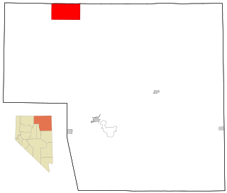
Elko County is a county in the northeastern corner of Nevada, United States. As of the 2020 census, the population was 53,702. Its county seat is Elko. The county was established on March 5, 1869, from Lander County.

<span class="mw-page-title-main">Elko, Nevada</span> City in Nevada, United States

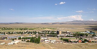
Elko is the largest city in and county seat of Elko County, Nevada, United States. With a 2020 population of 20,564, Elko is currently growing at a rate of 0.31% annually and its population has increased by 11.86% since the 2010 Census, which recorded a population of 18,297. Elko serves as the economic hub of the Ruby Valley, a region with a population of over 55,000. Elko is 21 miles (34 km) from Lamoille Canyon and the Ruby Mountains, dubbed the Swiss Alps of Nevada, providing year round access to recreation including hiking, skiing, hunting, and more than 20 alpine lakes. The city straddles the Humboldt River. Spring Creek, Nevada, serves as a bedroom community 6 miles (9.7 km) from the city with a population of 13,805.

<span class="mw-page-title-main">Owyhee, Nevada</span> Census-designated place in Nevada, United States

Owyhee is a census-designated place (CDP) in Elko County, Nevada, United States, along the banks of the Owyhee River. The population was 953 at the 2010 census. It is part of the Elko Micropolitan Statistical Area. It is the primary town of the federally recognized Shoshone-Paiute tribe's Duck Valley Indian Reservation, which covers portions of northern Nevada and southern Idaho, and the majority of its population are Native American.

<span class="mw-page-title-main">Humboldt–Toiyabe National Forest</span> National forest in Nevada and California, United States

The Humboldt–Toiyabe National Forest (HTNF) is the principal U.S. National Forest in the U.S. state of Nevada, and has a smaller portion in Eastern California. With an area of 6,289,821 acres (25,454.00 km2), it is the largest U.S. National Forest outside of Alaska.

<span class="mw-page-title-main">Jackpot, Nevada</span> Census-designated place in Nevada, United States

Jackpot is an unincorporated community and census-designated place (CDP) in Elko County, Nevada, United States. The population was 855 as of the 2020 census. Located less than one mile (1.6 km) from the Idaho border on US 93, Jackpot has been a popular casino gaming destination for residents of Idaho and other neighboring states since its founding.

<span class="mw-page-title-main">Bruneau River</span> River in Idaho and Nevada, United States

The Bruneau River is a 153-mile-long (246 km) tributary of the Snake River, in the U.S. states of Idaho and Nevada. It runs through a narrow canyon cut into ancient lava flows in southwestern Idaho. The Bruneau Canyon, which is up to 1,200 feet (370 m) deep and 40 miles (64 km) long, features rapids and hot springs, making it a popular whitewater trip.

<span class="mw-page-title-main">Humboldt River</span> River drainage system in north-central Nevada, United States

The Humboldt River is an extensive river drainage system located in north-central Nevada. It extends in a general east-to-west direction from its headwaters in the Jarbidge, Independence, and Ruby Mountains in Elko County, to its terminus in the Humboldt Sink, approximately 225 direct miles away in northwest Churchill County. Most estimates put the Humboldt River at 300 to 330 miles long however, due to the extensive meandering nature of the river, its length may be more closely estimated at 380 miles (610 km). It is located within the Great Basin Watershed and is the third longest river in the watershed behind the Bear River at 355 miles (571 km) and the Sevier River at 325 miles (523 km). The Humboldt River Basin is the largest sub-basin of the Great Basin encompassing an area of 16,840 square miles (43,600 km2). It is the only major river system wholly contained within the state of Nevada.

<span class="mw-page-title-main">Owyhee River</span> River in Nevada, Idaho, and Oregon, United States

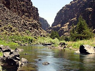
The Owyhee River is a tributary of the Snake River located in northern Nevada, southwestern Idaho and southeastern Oregon in the United States. It is 280 miles (450 km) long. The river's drainage basin is 11,049 square miles (28,620 km2) in area, one of the largest subbasins of the Columbia Basin. The mean annual discharge is 995 cubic feet per second (28.2 m3/s), with a maximum of 50,000 cu ft/s (1,400 m3/s) recorded in 1993 and a minimum of 42 cu ft/s (1.2 m3/s) in 1954.

<span class="mw-page-title-main">Lamoille, Nevada</span> Census-designated place in Nevada, United States

Lamoille is a rural census-designated place in Elko County in the northeastern section of the state of Nevada in the western United States. As of the 2020 census it had a population of 276. It is located 19 miles (31 km) southeast of Elko at the base of the Ruby Mountains at an elevation of 5,889 feet (1,795 m) and is part of the Elko Micropolitan Statistical Area.

<span class="mw-page-title-main">Jarbidge Wilderness</span> Federally-designated wilderness area in Nevada

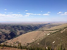
The Jarbidge Wilderness is a wilderness area located in the Jarbidge Mountains of northern Elko County in northeastern Nevada, United States. It is contained within the Jarbidge Ranger District of the Humboldt-Toiyabe National Forest.

<span class="mw-page-title-main">Jarbidge River</span> River in Nevada and Idaho, United States

The Jarbidge River is a 51.8-mile-long (83.4 km), high elevation river in Elko County, Nevada and Owyhee County, Idaho in the United States. The Jarbidge originates as two main forks in the Jarbidge Mountains of northeastern Nevada and then flows through basalt and rhyolite canyons on the high plateau of the Owyhee Desert before joining the Bruneau River.

<span class="mw-page-title-main">Jarbidge Mountains</span>

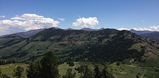
The Jarbidge Mountains are a mountain range in northern Elko County, Nevada, United States. The range includes multiple sub-ranges, including the Bruneau Range, Buck Creek Mountains, Copper Mountains, Elk Mountains, Fox Creek Range, Ichabod Range, Marys River Range, Salmon River Range and Wild Horse Range. The central core of the range, including most of the peaks above 10,500 feet (3,200 m), extends southward approximately 5 miles (8 km) from a point near the small community of Jarbidge.

<span class="mw-page-title-main">Mountain City, Nevada</span> Census-designated place in Nevada, United States

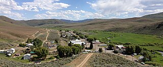
Mountain City is a small census-designated place in Elko County, Nevada, United States, within the Mountain City Ranger District of the Humboldt-Toiyabe National Forest. The community, located on State Route 225 approximately 16 miles (26 km) south of the Idaho border, is situated on the Owyhee River at an elevation of approximately 5,620 feet (1,710 m).

<span class="mw-page-title-main">Idaho State Highway 51</span> State highway in southwestern Idaho from Mountain Home south to the Nevada border

State Highway 51 (SH-51) is a state highway in southwestern Idaho from Mountain Home south to the Nevada border, where it continues as State Route 225 to Elko. It is the major north–south road in Owyhee County.

<span class="mw-page-title-main">Charleston, Nevada</span> Ghost town in Nevada, United States

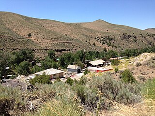
Charleston is a ghost town in Elko County, Nevada, United States. It lies along the Bruneau River just south of the Mountain City and Jarbidge Ranger Districts of the Humboldt-Toiyabe National Forest and is near the southwest edge of the Jarbidge Wilderness.

<span class="mw-page-title-main">Sheep Creek (Bruneau River tributary)</span> River in Nevada, United States

Sheep Creek is a 63-mile (101 km) long tributary of the Bruneau River. Beginning at an elevation of 6,126 feet (1,867 m) east of Owyhee in northern Elko County, Nevada, it flows generally north into Owyhee County, Idaho and the Owyhee Desert, where it is roughly paralleled by Idaho State Highway 51. It then flows to its mouth in the Bruneau – Jarbidge Rivers Wilderness, at an elevation of 3,415 feet (1,041 m). In 2009, 25.6 miles (41.2 km) of the creek were designated as wild by the Omnibus Public Land Management Act, which also created the Bruneau – Jarbidge Rivers Wilderness.

<span class="mw-page-title-main">Coon Creek Peak</span> Mountain in Elko County, Nevada, US

Coon Creek Peak is a mountain in northern Elko County, Nevada, about 4 miles southwest of the community of Jarbidge. It is considered to be the most northeasterly peak of the Copper Mountains. Located a few miles west of the main crest of the Jarbidge Mountains, it is located within the Jarbidge Ranger District of the Humboldt-Toiyabe National Forest. The main road entering Jarbidge from the south, Charleston-Jarbidge Road, runs along the western slopes of the mountain as it travels between Coon Creek Summit and Bear Creek Summit, providing close vehicular access to the summit of Coon Creek Peak.

<span class="mw-page-title-main">Jarbidge Peak</span>

Jarbidge Peak is the second highest mountain in the Jarbidge Mountains of northern Elko County, Nevada, United States. It is located within the Jarbidge Ranger District of the Humboldt-Toiyabe National Forest. The boundary of the Jarbidge Wilderness crosses the peak.

<span class="mw-page-title-main">Copper Basin (Nevada)</span>

Copper Basin is a basin located between the Copper Mountains and Fox Creek Range of northern Elko County, Nevada, United States. The basin, located on the border of the Mountain City and Jarbidge ranger districts within the Humboldt-Toiyabe National Forest, is known for its displays of wildflowers during early summer. It is accessed via Elko County Route 748, also known as Charleston-Jarbidge Road, by way of either Charleston or Jarbidge.

<span class="mw-page-title-main">Murphy Hot Springs, Idaho</span> Unincorporated community in Owyhee County, Idaho, United States

Murphy Hot Springs is an unincorporated community in Owyhee County, Idaho, United States.

References

  1. "Jarbidge ZIP Code". zipdatamaps.com. 2022. Retrieved November 11, 2022.
  2. "Jarbidge, Nevada". Geographic Names Information System . United States Geological Survey, United States Department of the Interior.
  3. zip-info.com
  4. "CFR 2013 Title 49 Volume 1 Part 71 STANDARD TIME ZONE BOUNDARIES" (PDF). www.gpo.gov. Retrieved July 5, 2014.
  5. "Time Zone Exceptions and Oddities" . Retrieved January 26, 2014.
  6. "Jarbridge piece". Reno Gazette-Journal. April 29, 2012. pp. D4. Retrieved November 17, 2022.
  7. Nestor, Sandy (November 29, 2004). Indian Placenames in America. McFarland. p. 104. ISBN   978-0-7864-7167-6.
  8. Federal Writers' Project (1941). Origin of Place Names: Nevada (PDF). W.P.A. p. 25.
  9. "Jarbidge- Nevada Ghost Town" . Retrieved November 25, 2013.
  10. Sebesta, Paul. "GET ME TO JARBIDGE!". Nevada Landmarks. Retrieved November 24, 2013.
  11. 1 2 "NOAA Online Weather Data – NWS Elko". National Weather Service. Retrieved February 9, 2023.
  12. "Jarbidge 7 N, Nevada 1991-2020 Monthly Normals" . Retrieved November 9, 2023.
  13. "xmACIS". National Oceanic and Atmospheric Administration. Retrieved November 9, 2023.
  14. "U.S. Climate Normals Quick Access – Station: Gibbs RCH - Jarbidge 24SE, NV". National Oceanic and Atmospheric Administration. Retrieved February 9, 2023.