San Jacinto, Nevada

Last updated
San Jacinto, Nevada
USA Nevada location map.svg
Red pog.svg
San
Jacinto
Location of San Jacinto
Usa edcp location map.svg
Red pog.svg
San
Jacinto
San
Jacinto (the United States)
Coordinates: 41°52′07″N114°40′35″W / 41.86861°N 114.67639°W / 41.86861; -114.67639 Coordinates: 41°52′07″N114°40′35″W / 41.86861°N 114.67639°W / 41.86861; -114.67639 [1]
Country United States
State Nevada
County Elko
Elevation
[1]
5,200 ft (1,585 m)
Time zone UTC-8 (Pacific (PST))
  Summer (DST) UTC-7 (PDT)
ZIP code
89825
Area code 775
GNIS feature ID845648 [1]

San Jacinto is a ghost town in along Salmon Falls Creek in northern Elko County, Nevada, United States. [1] It is part of the Elko Micropolitan Statistical Area.

Contents

It was the site of a railroad station located eight miles northeast of Contact, Nevada on the Union Pacific railroad. [2]

It is named after the San Jacinto Ranch, [3] which in turn is named for the Battle of San Jacinto, fought at present-day Houston, Texas in 1836. [2]

The San Jacinto post office was in operation from November 1898 through April 1938. [4]

The lowest temperature ever recorded in Nevada, −50 °F (−46 °C) was recorded in San Jacinto on January 8, 1937. [5]

The site of the former community is just east of U.S. Route 93.or the Great Basin Highway. [6] Most of what remains of the ghost town is what is now the San Jacinto Ranch.

San Jacinto Ranch, just off U.S. Route 93, July 2009 San Jacinto Ranch on the way HWY 93 NV - panoramio.jpg
San Jacinto Ranch, just off U.S. Route 93, July 2009

Climate

Climate data for San Jacinto, Nevada
MonthJanFebMarAprMayJunJulAugSepOctNovDecYear
Record high °F (°C)65
(18)
68
(20)
74
(23)
85
(29)
92
(33)
100
(38)
104
(40)
108
(42)
95
(35)
90
(32)
78
(26)
68
(20)
108
(42)
Average high °F (°C)36.5
(2.5)
41.3
(5.2)
49.7
(9.8)
58.6
(14.8)
66.6
(19.2)
76.2
(24.6)
87.4
(30.8)
84.9
(29.4)
76.0
(24.4)
62.8
(17.1)
49.5
(9.7)
40.2
(4.6)
60.8
(16.0)
Average low °F (°C)11.4
(−11.4)
16.8
(−8.4)
22.7
(−5.2)
28.7
(−1.8)
34.4
(1.3)
39.8
(4.3)
45.4
(7.4)
41.3
(5.2)
33.3
(0.7)
25.9
(−3.4)
18.3
(−7.6)
13.6
(−10.2)
27.6
(−2.4)
Record low °F (°C)−50
(−46)
−34
(−37)
−16
(−27)
−3
(−19)
11
(−12)
19
(−7)
30
(−1)
21
(−6)
10
(−12)
0
(−18)
−22
(−30)
−45
(−43)
−50
(−46)
Average precipitation inches (mm)0.66
(17)
0.47
(12)
0.59
(15)
0.93
(24)
1.29
(33)
1.16
(29)
0.51
(13)
0.48
(12)
0.47
(12)
0.60
(15)
0.62
(16)
0.56
(14)
8.34
(212)
Average snowfall inches (cm)7.1
(18)
4.5
(11)
3.7
(9.4)
2.8
(7.1)
1.3
(3.3)
0.2
(0.51)
0.0
(0.0)
0.0
(0.0)
0.3
(0.76)
0.7
(1.8)
3.1
(7.9)
5.3
(13)
28.9
(73)
Source: WRCC [7]

Related Research Articles

<span class="mw-page-title-main">Black Rock Desert</span> Northwest Nevada dry lake

The Black Rock Desert is a semi-arid region of lava beds and playa, or alkali flats, situated in the Black Rock Desert–High Rock Canyon Emigrant Trails National Conservation Area, a silt playa 100 miles (160 km) north of Reno, Nevada that encompasses more than 300,000 acres (120,000 ha) of land and contains more than 120 miles (200 km) of historic trails. It is in the northern Nevada section of the Great Basin with a lakebed that is a dry remnant of Pleistocene Lake Lahontan.

Vya is a small ghost town located in Washoe County, in northwestern Nevada, United States. It is about 10 miles (16 km) east of the California state line, north of Forty Nine Canyon. Not much remains of the small town, which essentially died in the 1920s. Just two wooden buildings can still be seen—the Vya Post Office and Library. The Vya Post Office was in operation from September 1910 until October 1941. The settlement was named for Vya Wimer, the first European heritage baby born in the valley.

<span class="mw-page-title-main">Deeth, Nevada</span> Unincorporated community located in the State of Nevada, United States of America

Deeth is an unincorporated community and census-designated place near the intersection of Interstate 80 and Nevada State Route 230 in Elko County, Nevada, United States.

<span class="mw-page-title-main">Nevada State Route 228</span>

State Route 228 (SR 228), also known as Jiggs Highway, is a 20.803-mile (33.479 km) state highway in Elko County, Nevada, United States, that connects Jiggs with Nevada State Route 227 in Spring Creek.

Contact is an unincorporated community in Elko County, Nevada, United States. It is located on a mineral-rich granite intrusion and there are many mines nearby.

<span class="mw-page-title-main">Cobre, Nevada</span> Ghost town in Nevada, United States

Cobre is a ghost town in Elko County, Nevada, United States.

<span class="mw-page-title-main">Halleck, Nevada</span> Unincorporated community located in the State of Nevada, United States of America

Halleck is an unincorporated community in central Elko County, northeastern Nevada, in the Western United States.

<span class="mw-page-title-main">Osino, Nevada</span> Census-designated place in Nevada, United States

Osino is a census-designated place (CDP) in along the Humboldt River in central Elko County, Nevada, United States. As of the 2018 United States Census American Community Survey it had a population of 661.

Schellbourne, formerly known as Fort Schellbourne and Schell Creek Station is a ghost town located in the Schell Creek Range in White Pine County in Nevada, United States, located 43 miles (69 km) north of Ely. The town was a stopover along the Central Overland Route, Pony Express and original routing of the Lincoln Highway. It is today Nevada Historical Marker number 51. The site was listed on the National Register of Historic Places in 1972. Its boundaries were increased in 1977.

Arthur is an unincorporated community and ghost town in Nevada, United States.

Rowland is a ghost town in northern Elko County, Nevada, United States.

Toano is a ghost town in Elko County, Nevada, in the United States.

Afton is a ghost town Elko County, Nevada, in the United States.

<span class="mw-page-title-main">Charleston, Nevada</span> Ghost town in Nevada, United States

Charleston is a ghost town in Elko County, Nevada, United States. It lies along the Bruneau River just south of the Mountain City and Jarbidge Ranger Districts of the Humboldt-Toiyabe National Forest and is near the southwest edge of the Jarbidge Wilderness.

Pyramid is an unincorporated community in Washoe County, Nevada, United States. At one time, it was a station on the Fernley and Lassen Railway located between Bristol and Big Canyon. There was a post office at this location from March 1904 until November 1959.

Huntington is a ghost town in Elko County, Nevada, United States.

<span class="mw-page-title-main">Ola, Nevada</span> Ghost town in Nevada, United States

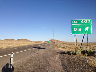
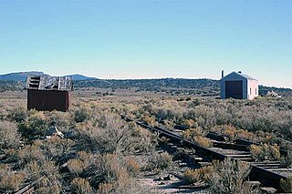
Ola is a ghost town and railroad siding in eastern Elko County, Nevada, United States.

Dutton is a ghost town in Elko County, in the U.S. state of Nevada.

Excelsior is a ghost town in Elko County, in the U.S. state of Nevada.

Fairlawn is a ghost town in Elko County, in the U.S. state of Nevada.

References

  1. 1 2 3 4 "San Jacinto". Geographic Names Information System . United States Geological Survey, United States Department of the Interior.
  2. 1 2 Carlson, Helen S. (1985). Nevada Place Names: A Geographical Dictionary. University of Nevada Press. ISBN   978-0-87417-094-8 . Retrieved June 7, 2020.
  3. "San Jacinto Ranch". Geographic Names Information System . United States Geological Survey, United States Department of the Interior.
  4. U.S. Geological Survey Geographic Names Information System: San Jacinto Post Office (historical)
  5. National Climatic Data Center. "State Climate Extremes Committee (SCEC)" . Retrieved March 22, 2015.
  6. Google (May 27, 2020). "San Jacinto, Nevada 89825" (Map). Google Maps . Google. Retrieved May 27, 2020.
  7. "SAN JACINTO, NEVADA (267284)". Desert Research Institute . Retrieved June 12, 2016.

Commons-logo.svg Media related to San Jacinto, Nevada at Wikimedia Commons