
Katanning is a town located 277 kilometres (172 mi) south-east of Perth, Western Australia on the Great Southern Highway. At the 2016 census, Katanning had a population of 3,687.
Rosebery is a town on the west coast of Tasmania, Australia. It is at the northern end of the West Coast Range, in the shadow of Mount Black and adjacent to the Pieman River now Lake Pieman.

Busselton is a city in the South West region of the state of Western Australia approximately 220 km (140 mi) south-west of Perth. Busselton has a long history as a popular holiday destination for Western Australians; however, the closure of the Busselton Port in 1972 and the contemporaneous establishment of the nearby Margaret River wine region have seen tourism become the dominant source of investment and development, supplemented by services and retail. The city is best known for the Busselton Jetty, the longest wooden jetty in the Southern Hemisphere.

Capel is a town in the South West region of Western Australia, located 212 kilometres (132 mi) south of Perth and midway between Bunbury and Busselton. The town is located on the Capel River and is approximately 19 metres (62 ft) above sea level.

Dongara is a town 351 kilometres (218 mi) north-northwest of Perth, Western Australia on the Brand Highway. The town is located at the mouth of the Irwin River. The area is marketed as the 'Rock lobster capital of Australia'.
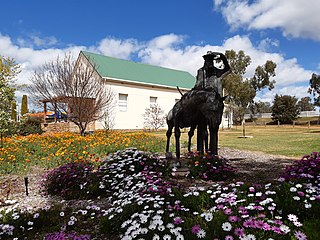
Nannup is a town in the South West region of Western Australia, approximately 280 kilometres (174 mi) south of Perth on the Blackwood River at the crossroads of Vasse Highway and Brockman Highway; the highways link Nannup to most of the lower South West's regional centres. At the 2011 census, Nannup had a population of 587.

The City of Busselton is a local government area in the South West region of Western Australia, approximately 230 km (140 mi) south of Perth, the state capital. The city covers an area of 1,455 km2 (562 sq mi) and had a population of 40,640 as at the 2021 Census. It contains two large towns, Busselton and Dunsborough, and a number of smaller towns. The city office is located on Southern Drive, Busselton.
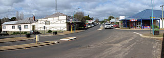
Wandering is a town located in the Wheatbelt region of Western Australia, approximately 120 kilometres (75 mi) from the state capital, Perth, just off the Albany Highway. It is the main town in the Shire of Wandering. At the 2016 census, Wandering had a population of 294.
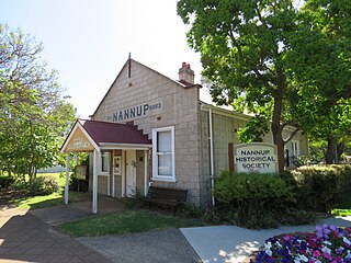
The Shire of Nannup is a local government area in the South West region of Western Australia, approximately 280 kilometres (174 mi) south of the state capital, Perth and 60 kilometres (37 mi) southeast of the coastal resort town of Busselton. Its seat of government is the town of Nannup, where about half of the Shire's population reside.
Karridale is a small township in the south-west of Western Australia. It is located just north of Augusta and south of Margaret River between Caves Road and Bussell Highway. A newer township was built a short distance north east of the original Old Karridale following fires that destroyed the town in 1961. At the 2006 census, Karridale had a population of 285.

Vasse is a suburb of the city of Busselton in the South West region of Western Australia, 10 kilometres (6 mi) west of Busselton and 240 kilometres (149 mi) southwest of Perth. Its local government area is the City of Busselton. At the 2021 census, Vasse had a population of 2,853.

Yallingup is a town in the South West region of Western Australia, 256 kilometres (159 mi) south of Perth. Yallingup is a popular tourist destination because of its beaches and limestone caves, and proximity to Leeuwin-Naturaliste National Park.
Quindalup is a small town in the South West region of Western Australia. It is situated along Caves Road between Busselton and Dunsborough on Geographe Bay. At the 2021 census, Quindalup had a population of 1,488.

Ludlow is a locality in the South West region of Western Australia near the Tuart Forest National Park. It is in the local government areas of the City of Busselton and the Shire of Capel. At the 2021 census, the area had a population of 132.

Metricup is a locality in the South West region of Western Australia near the town of Cowaramup on the Bussell Highway. It is in the Margaret River wine region and its local government area is the City of Busselton. At the 2021 census, it had a population of 263.
Yalyalup is a suburb of the Western Australian city of Busselton. At the 2021 census, it had a population of 2,950.

Broadwater is a suburb of the Western Australian city of Busselton. At the 2021 census, it had a population of 4,269.
Bovell is a semi-rural suburb of the Western Australian city of Busselton. At the 2021 census, it had a population of 475. The area has been earmarked for future urban development. Bovell contains Geographe Primary School, named after the nearby suburb, which was established in 2002.

Eagle Bay is a small town in Western Australia's South West region near Dunsborough, in the local government area of the City of Busselton. At the 2021 census, it had a population of 120. It is known for its luxury holiday homes, with an occupancy rate on the night of the 2021 census of about 13%.
Yelverton is a locality in Western Australia's South West region in the local government area of the City of Busselton. At the 2021 census, it had a population of 72. It was named after timber merchant Henry Yelverton, who established a timber mill there in 1856. The area was part of the Group Settlement Scheme, and a school existed there from 1934 to 1937. Yelverton National Park is in the locality.

