Java derives its name from Java coffee, and Coffee Town was an early variant name.[7] Java received its name from railroad crews on the Chicago, Milwaukee & St. Paul Railway Line who would stop for coffee in the town prior to the railroad's relocation in 1908.[8]
History
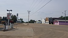
Main Street, Java in 2018.
Java was founded in 1900, shortly after the Chicago, Milwaukee & St. Paul Railway Line was extended from Bowdle to the Missouri River. The village was incorporated into a town by election in 1903 after survey of the townsite by Surveyor George Merriman of Bowdle on September 5 of that year.[8]
Many of the first homesteaders were of German, Russian, Dutch, English, and Hungarian ancestry. The Java Herald, the first newspaper serving the town, was established in 1903 by Carl F. Clement, and was printed in both English and German.[8]
In 1904, the first municipal building, a jail, was erected, in addition to gravel streets and an engine house equipped with a fire engine, hoses, and other related items. Additionally, the Dakota Central Telephone Company installed a telephone booth and switchboard at The Java House, Java's first hotel, founded in 1900 by H. A. Taylor. Later, wooden sidewalks, a water reservoir, a town hall, a town well, and a windmill (to grind grain) were added. These additions were paid by warrants issued by the town, and in 1906 a $2,000 bond issue was passed to remove the debt.[8]
In 1905, the Kupp Brothers, J. C. and George, supervised the installation of a more permanent telephone system in the town for the Dakota Telephone Co.[8]
By 1907, the town possessed fire protection, a cemetery association, water supply, municipal buildings, and improved telephone facilities. Another addition to the town was made when the Milwaukee Land Company had their property north of the railroad track surveyed and added.[8]
From 1908-1909, the railroad company rerouted its track, passing north of the town by one-half mile. The citizens received a proposal from railroad officials to move the town north, however, this proposal was refused, and the town was served thereafter by a spur line constructed by the company.[8]
By 1913, the town had a Catholic, a Presbyterian, a German Lutheran, and a German Congregational Church. In 1915, the wooden sidewalks along Main street were removed and replaced with cement sidewalks. Later that year, the town hall was remodeled, the jail was moved, a bell tower was constructed. In 1916, a municipal light plant was constructed. In 1921, a schoolhouse was constructed, and at this time Java was incorporated from a town into a city, and adopted the Mayor-Alderman form of government, the first mayor under this new system being Carl F. Clement. In 1939, a Public Works Administration project was begun, creating a waterworks system to include both commercial and private users.[8]
In 1947, the city saw the creation of a park board that established a city park just west of the school house.[8]
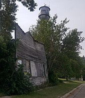
The old blacksmith shop in Java, in 2018, opened by John Banik in 1901.
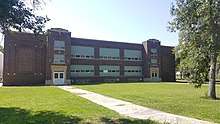
Java High School
Grain elevators in Java, in 2018.
In 1901, the first term of school was help in a building that had been relocated into town, serving twenty-three students, ranging in age from five to eighteen years. In 1903, a frame school building was built on the site two blocks east of Main Street and was used until 1921, when the fireproof brick schoolhouse was constructed.[9]
The old schoolhouse in Java built in 1921. Photo taken in 2018.
As of the census[12] of 2010, there were 129 people, 69 households, and 38 families residing in the town. The population density was 263.3 inhabitants per square mile (101.7/km2). There were 119 housing units at an average density of 242.9 per square mile (93.8/km2). The racial makeup of the town was 93.0% White, 3.1% Native American, and 3.9% from two or more races.
There were 69 households, of which 13.0% had children under the age of 18 living with them, 44.9% were married couples living together, 7.2% had a female householder with no husband present, 2.9% had a male householder with no wife present, and 44.9% were non-families. 40.6% of all households were made up of individuals, and 24.6% had someone living alone who was 65 years of age or older. The average household size was 1.87 and the average family size was 2.47.
The median age in the town was 57.1 years. 14% of residents were under the age of 18; 3.2% were between the ages of 18 and 24; 15.5% were from 25 to 44; 30.4% were from 45 to 64; and 37.2% were 65 years of age or older. The gender makeup of the town was 45.0% male and 55.0% female.
2000 census
As of the census[5] of 2000, there were 197 people, 94 households, and 56 families residing in the town. The population density was 410.9 inhabitants per square mile (158.6/km2). There were 133 housing units at an average density of 277.4 per square mile (107.1/km2). The racial makeup of the town was 95.94% White and 4.06% Native American.
There were 94 households, out of which 13.8% had children under the age of 18 living with them, 56.4% were married couples living together, 4.3% had a female householder with no husband present, and 39.4% were non-families. 37.2% of all households were made up of individuals, and 25.5% had someone living alone who was 65 years of age or older. The average household size was 2.10 and the average family size was 2.72.
In the town, the population was spread out, with 16.2% under the age of 18, 3.0% from 18 to 24, 20.3% from 25 to 44, 23.9% from 45 to 64, and 36.5% who were 65 years of age or older. The median age was 56 years. For every 100 females, there were 103.1 males. For every 100 females age 18 and over, there were 98.8 males.
The median income for a household in the town was $29,125, and the median income for a family was $36,875. Males had a median income of $20,625 versus $14,750 for females. The per capita income for the town was $19,427. About 6.4% of families and 11.0% of the population were below the poverty line, including 9.4% of those under the age of eighteen and 6.5% of those 65 or over.
Related Research Articles
Underwood is a town in Pottawattamie County, Iowa, United States. The population was 954 at the time of the 2020 census.
Hector is a city in Renville County, Minnesota, United States. The population was 1,012 at the 2020 census.
Monango is a city in Dickey County, North Dakota, United States. The population was 30 at the 2020 census. Monango was founded in 1886.
Hannaford is a city in Griggs County, North Dakota, United States. The population was 126 at the 2020 census. Hannaford was founded in 1883.
McVille is a city in Nelson County, North Dakota, United States. The population was 392 at the 2020 census. McVille was founded in 1906.
Mylo is a city in Rolette County, North Dakota, United States. The population was 21 at the 2020 census. Other than a United States Post Office, there are no businesses or services at Mylo.
Plankinton is a city in and county seat of Aurora County, South Dakota, United States. The population was 781 at the 2020 census.
Westport is a town in western Brown County, South Dakota, United States. The population was 88 at the 2020 census.
Platte is a city in Charles Mix County, South Dakota, United States. The population was 1,311 at the 2022 census. The community is named after the Platte Creek, a tributary of the Missouri River reservoir Lake Francis Case. Platte is located 15 miles east of Lake Francis Case on the Missouri River.
Buffalo Gap is a town in Custer County, South Dakota, United States. The population was 131 at the 2020 census.
Bristol is a city located in western Day County, South Dakota, United States. It lies in Section 25 of Bristol Township, on the main line of what is now the BNSF Railway alongside U.S. Route 12. The population was 288 at the 2020 census.`
Goodwin is a town in Deuel County, South Dakota, United States, where the population was 147 at the 2020 census.
Isabel is a town in Dewey County, South Dakota, United States. The population was 145 at the 2020 census.
Corsica is a city in Douglas County, South Dakota, United States. The population was 561 at the 2020 census.
Bowdle ( is a city in Edmunds County, South Dakota, United States. The population was 470 at the 2020 census.
Kadoka is a city in, and the county seat of, Jackson County, South Dakota, United States. The population was 543 at the 2020 census. The town occupies about 2.3 square miles.
Wessington Springs is a town in central Jerauld County, South Dakota, United States. The population was 956 at the 2010 census. It is the county seat of Jerauld County.
Keystone is a town in the Black Hills region of Pennington County, South Dakota, United States. The population was 240 at the 2020 census. It had its origins in 1883 as a mining town, and has since transformed itself into a resort town, serving the needs of the millions of visitors to the Mount Rushmore National Memorial, which is located just beyond the town limits. Keystone was heavily damaged in the 1972 Black Hills flood.
Rosholt is a town in Roberts County, South Dakota, United States. The population was 379 at the 2020 census.
Brentford is a town in Spink County, South Dakota, United States. The population was 88 at the 2020 census.
This page is based on this Wikipedia article Text is available under the CC BY-SA 4.0 license; additional terms may apply. Images, videos and audio are available under their respective licenses.