Lowry, South Dakota

Last updated

Lowry
Lowry, South Dakota
Town of Lowry and Swan Creek (51360870410).jpg
Walworth County South Dakota Incorporated and Unincorporated areas Lowry Highlighted.svg
Location in Walworth County and the state of South Dakota
Coordinates: 45°18′56″N99°58′52″W / 45.31556°N 99.98111°W / 45.31556; -99.98111
Country United States
State South Dakota
County Walworth
Area
[1]
  Total0.25 sq mi (0.66 km2)
  Land0.25 sq mi (0.66 km2)
  Water0.00 sq mi (0.00 km2)
Elevation
[2]
1,864 ft (568 m)
Population
 (2020) [3]
  Total10
  Density39.53/sq mi (15.27/km2)
Time zone UTC-6 (Central (CST))
  Summer (DST) UTC-5 (CDT)
ZIP code
57472
Area code 605
FIPS code 46-39260 [4]
GNIS feature ID1267465 [2]

Lowry is a town in Walworth County, South Dakota, United States. The population was 10 at the 2020 census. [5] The town is home to Lowry Pilgrim Community Church, Swan Creek Harness Shop, J & C Repair, Karst Service (closed in August 2015) and a fire station. Lowry also has an abandoned school, and a post office, which closed to service in the early 1970s.

Contents

Lowry was founded in 1907 as a station stop on a branch line of the Minneapolis and St. Louis Railway built that year between Conde and LeBeau, South Dakota. The town was named in honor of a railroad employee. [6] Railway service to Lowry ended in 1940.

Geography

According to the United States Census Bureau, the town has a total area of 0.25 square miles (0.65 km2), all land. [7]

Demographics

Historical population
CensusPop.Note
1910 90
1930 89
1940 901.1%
1950 70−22.2%
1960 44−37.1%
1970 35−20.5%
1980 22−37.1%
1990 15−31.8%
2000 10−33.3%
2010 6−40.0%
2020 1066.7%
U.S. Decennial Census [8]
2013 Estimate [9] [3]

2010 census

As of the census [10] of 2010, there were 6 people, 3 households, and 3 families residing in the town. The population density was 24.0 inhabitants per square mile (9.3/km2). There were 6 housing units at an average density of 24.0 per square mile (9.3/km2). The racial makeup of the town was 83.3% White and 16.7% Native American.

There were 3 households, of which 100.0% were married couples living together. 0.0% of all households were made up of individuals. The average household size was 2.00 and the average family size was 2.00.

The median age in the town was 71.5 years. 0.0% of residents were under the age of 18; 0.0% were between the ages of 18 and 24; 0.0% were from 25 to 44; 33.3% were from 45 to 64; and 66.7% were 65 years of age or older. The gender makeup of the town was 50.0% male and 50.0% female.

2000 census

As of the census [4] of 2000, there were 10 people, 5 households, and 4 families residing in the town. The population density was 41.6 inhabitants per square mile (16.1/km2). There were 6 housing units at an average density of 24.9 per square mile (9.7/km2). The racial makeup of the town was 100.00% White.

There were 5 households, out of which 1 had children under the age of 18 living with them, 4 were married couples living together, none had a female householder with no husband present, and 1 was a non-family. One household was made up of individuals, and one had someone living alone who was 65 years of age or older. The average household size was two people and the average family size was 2.25 people.

In the town, the population was spread out, with 1 person under the age of 18, two from 18 to 24, none from 25 to 44, four from 45 to 64, and three who were 65 years of age or older. The median age was 53 years. There were an equal number of females and males. For every 100 females age 18 and over, there were 125.0 males.

The median income for a household in the town was $23,750, and the median income for a family was $43,750. Males had a median income of $0, as did females. The per capita income for the town was $18,570. Two people but no families were below the poverty line. Out of the total population, none of those under the age of 18 and 33.3% of those 65 and older were living below the poverty line.

Related Research Articles

<span class="mw-page-title-main">Lowry, Minnesota</span> City in Minnesota, United States

Lowry is a city in Pope County, Minnesota, United States. The population was 334 at the 2020 census.

<span class="mw-page-title-main">Briarwood, North Dakota</span> City in North Dakota, United States

Briarwood is a city in Cass County, North Dakota, United States. The population was 57 at the 2020 census. Briarwood was founded in 1973. It is a suburb directly adjacent to the city of Fargo.

<span class="mw-page-title-main">Braddock, North Dakota</span> City in Emmons County, North Dakota, United States

Braddock is a city in Emmons County, North Dakota, United States. The population was 18 at the 2020 census. Braddock was founded in 1898.

<span class="mw-page-title-main">Rocklake, North Dakota</span> City in North Dakota, United States

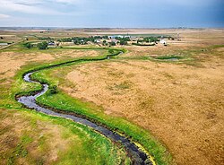
Rocklake is a city in Towner County, North Dakota, United States. The population was 94 at the 2020 census. The city lies a few miles south of the Canada–United States border, near the junction of U.S. Route 281 and North Dakota State Highway 5.

<span class="mw-page-title-main">Cavour, South Dakota</span> Town in South Dakota, United States

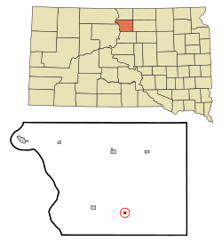
Cavour is a town in Beadle County, South Dakota, United States. The population was 128 at the 2020 census.

<span class="mw-page-title-main">Wolsey, South Dakota</span> Town in South Dakota, United States

Wolsey is a town in Beadle County, South Dakota, United States. The population was 459 at the 2020 census.

<span class="mw-page-title-main">Bushnell, South Dakota</span> Town in South Dakota, United States

Bushnell is a town in Brookings County, South Dakota, United States. The population was 71 at the 2020 census.

<span class="mw-page-title-main">White, South Dakota</span> City in South Dakota, United States

White is a city in Brookings County, South Dakota, United States. The population was 537 at the 2020 census.

<span class="mw-page-title-main">Bradley, South Dakota</span> Town in South Dakota, United States

Bradley is a town in Clark County, South Dakota, United States. The population was 65 at the 2020 census.

<span class="mw-page-title-main">Wallace, South Dakota</span> Town in South Dakota, United States

Wallace is a town in Codington County, South Dakota, United States. The population was 91 at the 2020 census. It is part of the Watertown, South Dakota Micropolitan Statistical Area.

<span class="mw-page-title-main">Onaka, South Dakota</span> Town in South Dakota, United States

Onaka is a town in Faulk County, South Dakota, United States. The population was 13 at the 2020 census.

<span class="mw-page-title-main">Harrold, South Dakota</span> Town in South Dakota, United States

Harrold is a town in Hughes County, South Dakota, United States. It is part of the Pierre, South Dakota Micropolitan Statistical Area. The population was 101 at the 2020 census.

<span class="mw-page-title-main">Wentworth, South Dakota</span> Village in South Dakota, United States

Wentworth is an incorporated village in Lake County, South Dakota, United States. It is the only incorporated village in the state of South Dakota. The population was 181 at the 2020 census.

<span class="mw-page-title-main">Central City, South Dakota</span> City in South Dakota, United States

Central City is a city in Lawrence County, South Dakota, United States. The population was 93 at the 2020 census.

<span class="mw-page-title-main">Lennox, South Dakota</span> City in South Dakota, United States

Lennox is a city in Lincoln County, South Dakota, United States, located 20 miles (32 km) southwest of Sioux Falls. The population was 2,423 at the 2020 census.

<span class="mw-page-title-main">Crooks, South Dakota</span> City in South Dakota, United States

Crooks is a city in Minnehaha County, South Dakota, United States and is a suburb of Sioux Falls. The population was 1,362 at the 2020 census. Crooks was named New Hope until 1904. The town's present name honors W. A. Crooks, a local politician.

<span class="mw-page-title-main">Trent, South Dakota</span> Town in South Dakota, United States

Trent is a town in Moody County, South Dakota, United States. The population was 206 at the 2020 census.

<span class="mw-page-title-main">Corona, South Dakota</span> Town in South Dakota, United States

Corona is a town in Roberts County, South Dakota, United States. The population was 69 at the 2020 census.

<span class="mw-page-title-main">White Rock, South Dakota</span> Town in South Dakota, United States

White Rock is a town in Roberts County, South Dakota, United States, along the Bois de Sioux River. The population was 6 at the 2020 census. White Rock is the most northeastern community in South Dakota, being along the Minnesota border and one mile south of North Dakota.

<span class="mw-page-title-main">Ashton, South Dakota</span> City in South Dakota, United States

Ashton is a city in eastern Spink County, South Dakota, United States. The population was 108 at the 2020 census.

References

  1. "ArcGIS REST Services Directory". United States Census Bureau. Retrieved October 15, 2022.
  2. 1 2 U.S. Geological Survey Geographic Names Information System: Lowry, South Dakota
  3. 1 2 "Census Population API". United States Census Bureau. Retrieved October 15, 2022.
  4. 1 2 "U.S. Census website". United States Census Bureau . Retrieved January 31, 2008.
  5. "U.S. Census Bureau: Lowry town, South Dakota". www.census.gov. United States Census Bureau. Retrieved January 22, 2022.
  6. Federal Writers' Project (1940). South Dakota place-names, v.1-3. University of South Dakota. p. 48.
  7. "US Gazetteer files 2010". United States Census Bureau. Archived from the original on July 2, 2012. Retrieved June 21, 2012.
  8. United States Census Bureau. "Census of Population and Housing" . Retrieved October 4, 2014.
  9. "Population Estimates". United States Census Bureau . Retrieved October 4, 2014.
  10. "U.S. Census website". United States Census Bureau . Retrieved June 21, 2012.