
Hydroelectricity, or hydroelectric power, is electricity produced from hydropower. In 2015, hydropower generated 16.6% of the world's total electricity and 70% of all renewable electricity, and was expected to increase by about 3.1% each year for the next 25 years.

Hugh Keenleyside Dam is a flood control dam spanning the Columbia River, 12 km upstream of the city of Castlegar, British Columbia, Canada.

Wyangala Dam is a major gated rock fill with clay core embankment and gravity dam with eight radial gates and a concrete chute spillway across the Lachlan River, located in the south-western slopes region of New South Wales, Australia. The dam's purpose includes flood mitigation, hydro-power, irrigation, water supply and conservation. The impounded reservoir is called Lake Wyangala.

Dams and reservoirs in Laos are the cornerstone of the Lao government's goal of becoming the "battery of Asia".

A reservoir is, most commonly, an enlarged natural or artificial lake, pond, or impoundment created using a dam or lock to store water.

Copeton Dam is a major clay core and rock fill embankment dam with nine radial gates and a gated concrete chute spillway across the Gwydir River upstream of Bingara in the New England region of New South Wales, Australia. The dam's purpose includes environmental flows, hydro-electric power generation, irrigation, and water supply. The impounded reservoir is called Lake Copeton.

Kerr Lake /kɑr/ is a reservoir along the border of the U.S. states of North Carolina and Virginia. It is impounded by the John H. Kerr Dam, constructed between 1947 and 1952 to produce hydroelectricity and to provide flood control. Kerr Lake is owned by the US Army Corps of Engineers, and is the largest reservoir in Virginia. It is located in parts of Vance, Granville, and Warren counties in North Carolina, and Mecklenburg, Charlotte, and Halifax counties in Virginia. At its maximum capacity, it is one of the largest reservoirs in the Southeastern United States, covering approximately 50,000 acres (200 km2) and bordered by over 850 miles (1,370 km) of shoreline. The lake is named for Congressman John H. Kerr of North Carolina, who supported the original creation of the lake.
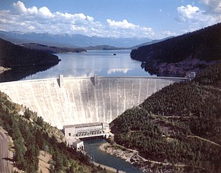
Hungry Horse Dam is an arch dam in the western United States, on the South Fork Flathead River in the Rocky Mountains of northwest Montana. It is located in Flathead National Forest in Flathead County, about fifteen miles (24 km) south of the west entrance to Glacier National Park, nine miles (14 km) southeast of Columbia Falls, and twenty miles (32 km) northeast of Kalispell. The Hungry Horse project, dam, and powerplant are operated by the U.S. Bureau of Reclamation. The entrance road leading to the dam is located in Hungry Horse.
Run-of-river hydroelectricity (ROR) or run-of-the-river hydroelectricity is a type of hydroelectric generation plant whereby little or no water storage is provided. Run-of-the-river power plants may have no water storage at all or a limited amount of storage, in which case the storage reservoir is referred to as pondage. A plant without pondage is subject to seasonal river flows, thus the plant will operate as an intermittent energy source. Conventional hydro uses reservoirs, which regulate water for flood control, dispatchable electrical power, and the provision of fresh water for agriculture.

Folsom Dam is a concrete gravity dam on the American River of Northern California in the United States, about 25 mi (40 km) northeast of Sacramento. The dam is 340 ft (100 m) high and 1,400 ft (430 m) long, flanked by earthen wing dams. It was completed in 1955, officially opening the following year.

The Caruachi Dam is a concrete gravity dam on the Caroní River in Bolivar state, Venezuela. The dam supports a hydroelectric power facility with a 2,160 megawatts (2,900,000 hp) capacity. The facility is located about 59 kilometres (37 mi) downstream from the Guri Dam belonging to the "Central Hidroeléctrica Simón Bolívar" and about 35 kilometres (22 mi) from where the Caroni and Orinoco rivers meet at Ciudad Guayana.

Bicaz-Stejaru Hydro Power Plant is a hydropower development on the Bistriţa River, near Bicaz, Romania.

The Boguchany Dam is a large hydroelectric dam on the Angara River in Kodinsk, Krasnoyarsk Krai, Russia. It has an installed capacity of 2,997 MW. Construction of the power plant was completed when a ninth and final generator was brought online in January 2015.
Smith Mountain Dam is a concrete arch dam located on the Roanoke River in Virginia, creating Smith Mountain Lake. The dam was built by Appalachian Power between 1960 and 1963 for the purposes of pumped-storage hydroelectricity. The dam created Smith Mountain Lake as its reservoir, where recreation and real estate have become popular.
![J. Strom Thurmond Dam Dam in [[File:Georgia 150.svg|x20px|link=|alt=]] US 221 / SR 150, Columbia County, Georgia / McCormick County, South Carolina, USA](https://upload.wikimedia.org/wikipedia/commons/thumb/b/bb/ThurmondDam.jpg/320px-ThurmondDam.jpg)
J. Strom Thurmond Dam, also known in Georgia as Clarks Hill Dam, is a concrete-gravity and embankment dam located 22 miles (35 km) north of Augusta, Georgia on the Savannah River at the border of South Carolina and Georgia, creating Lake Strom Thurmond. U.S. Route 221 cross it. The dam was built by the U.S. Army Corps of Engineers between 1946 and 1954 for the purposes of flood control, hydroelectricity and downstream navigation. The concrete structure of the dam spans 1,096 feet (334 m) and rises 204 feet (62 m) above the riverbed, housing a power plant with an installed 380 MW capacity. The Dam has prevented over $185,000 in estimated flood damage annually and also provides recreation, water quality, water supply, along with fish and wildlife management.

Richard B. Russell Dam is a concrete-gravity and embankment dam located on the Savannah River at the border of South Carolina and Georgia, creating Richard B. Russell Lake. The dam was built by the U.S. Army Corps of Engineers between 1974 and 1985 for the purposes of flood control, hydroelectricity, recreation, additional stream flow regulation, water supply, and fish and wildlife management. The concrete structure of the dam spans 1,904 feet (580 m) and rises 210 feet (64 m) above the riverbed, housing a hydro-power plant with an installed 600 megawatts (800,000 hp) capacity. The Richard B. Russell Dam is the final large dam completed by the U.S. Army Corps in the Savannah River Basin and lies 30 miles downstream from the Hartwell Dam (1962) and 37 miles (60 km) upstream from the J. Strom Thurmond Dam (1954).

Manic-1 is a hydroelectric power station and dam at the mouth of the Manicouagan River 3 km (1.9 mi) west of Baie-Comeau, Quebec, Canada. The power station was commissioned between 1966 and 1967 and producing 184 MW, it is the smallest of the Manicouagan-Outardes project.

Stave Falls Dam is a dual-dam power complex on the Stave River in Stave Falls, British Columbia, Canada. The dam was completed in 1912 for the primary purpose of hydroelectric power production. To increase the capacity of Stave Lake, the dam was raised in 1925 and the Blind Slough Dam constructed in an adjacent watercourse 500 m (1,600 ft) to the north, which was the site of the eponymous Stave Falls. In 2000, the dam's powerhouse was replaced after a four-year upgrade. The powerhouse was once British Columbia's largest hydroelectric power source and is a National Historic Site of Canada.

The Çetin Dam hydropower dam, currently being constructed on the Botan River in Siirt Province, Turkey, with an installed capacity of 420 MW. It is expected to complete by 2020.

Mio Dam is a hydro-electric dam located on the Au Sable River in Michigan capable of generating 4.96 MW of electric power. It was the 4th of 6 dams built by Consumers Power between 1906 and 1924 along the Au Sable River and is the furthest upstream of the six. The dam was completed in 1916. The Mio Hydroelectric Plant consists of an embankment on each side connected by a spillway. Located North of the spillway is the powerhouse and outdoor substation. Public access to Mio Pond is provided via a boat ramp maintained by Consumers Energy, and portage facilities are also provided allowing canoes and kayaks access to bypass the dam. Portage the dam on the right using the cement stairs then carry down a gravel road with a canoe slide on the down river side of the dam. The Mio Dam powerhouse continues to operate with the same turbines and generators that were installed over a century ago.

