Etowah Indian Mounds (9BR1) are a 54-acre (220,000 m2) archaeological site in Bartow County, Georgia, south of Cartersville. Built and occupied in three phases, from 1000–1550 CE, the prehistoric site is located on the north shore of the Etowah River.

Lake Jackson Mounds Archaeological State Park (8LE1) is one of the most important archaeological sites in Florida, the capital of chiefdom and ceremonial center of the Fort Walton Culture inhabited from 1050–1500. The complex originally included seven earthwork mounds, a public plaza and numerous individual village residences.
Indian Mound Park, also known as Shell Mound Park or Indian Shell Mound Park, is a park and bird refuge located on the northern shore of Dauphin Island, a barrier island of Mobile County, Alabama in the United States. In addition to the many birds which visit, a wide variety of botanical species contribute to the natural offerings. The site is historically significant due to the presence of prehistoric Indian shell middens, mounds composed of discarded oyster shells. The park was added to the National Register of Historic Places on August 14, 1973. It is administered by the Alabama Department of Conservation and Natural Resources.

Horr's Island is a significant Archaic period archaeological site located on an island in Southwest Florida formerly known as Horr's Island. Horr's Island is on the south side of Marco Island in Collier County, Florida. The site includes four mounds and a shell ring. It has one of the oldest known mound burials in the eastern United States, dating to about 3400 radiocarbon years Before Present (BP). One of the mounds has been dated to as early as 6700 BP. It was the largest known community in the southeastern United States to have been permanently occupied during the Archaic period.
The Madira Bickel Mound State Archaeological Site is an archaeological site on Terra Ceia Island in northwestern Palmetto, Florida, United States. It is located on Bayshore Drive, west of U.S. 19, a mile south of I-275. On August 12, 1970, it was added to the U.S. National Register of Historic Places. It is also a Florida State Park.
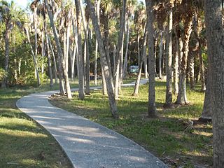
Mound Key Archaeological State Park is a Florida State Park, located in Estero Bay, near the mouth of the Estero River. One hundred and thirteen of the island's one hundred and twenty-five acres are managed by the park system. It is a complex of mounds and accumulated shell, fish bone, and pottery middens that rises more than 30 feet above the waters of the bay.
The Big Mound Key-Boggess Ridge Archeological District is a historic site near Placida, Florida. It is located southeast of Placida, on Big Mound Key. On December 3, 1990, it was added to the U.S. National Register of Historic Places.
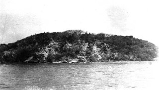
Turtle Mound is a prehistoric archaeological site located 9 miles (14 km) south of New Smyrna Beach, Florida, on State Road A1A. On September 29, 1970, it was added to the U.S. National Register of Historic Places. It is the largest shell midden on the mainland United States, with an approximate height of 50 feet (15 m). The mound extends for over 600 feet (180 m) along the Indian River shoreline and contains over 35,000 cubic yards (27,000 m3) of shells. Turtle Mound was estimated to be 75 feet (23 m) high before it was reduced by shellrock mining in the 19th and 20th centuries. Because it is visible seven miles out at sea, early Spanish explorers and subsequent mariners used the large mound as a landmark for coastal navigation. Today, the site is owned and managed by the National Park Service as part of Canaveral National Seashore.
The Garden Patch is a Middle Woodland archaeological site in Horseshoe Cove, near Horseshoe Beach, Florida, off County Road 351. For a major part of its occupation, the site was a ceremonial center associated with the Swift Creek and Weeden Island cultures. On April 25, 1991, it was added to the U.S. National Register of Historic Places.
The Pineland Archeological District is a U.S. historic district located on Pine Island, near Pineland, Florida, and next to Pine Island Sound. The site was occupied by people of the Caloosahatchee culture, known as the Calusa in historic times, from 500 BCE until after 1700. The site includes shell and sand mounds and other structures and prehistoric canals and artificial lakes. It also includes structures from the late 19th and early 20th centuries.

The Safety Harbor site is an archaeological site in Philippe Park at 2525 Philippe Parkway in Safety Harbor, Florida, United States. It is the type site for the Safety Harbor culture, and includes the largest remaining mound in the Tampa Bay area. It was designated a National Historic Landmark in 1964.

Mount Royal (8PU35) is a U.S. archaeological site close to where the St. Johns River exits from Lake George in Putnam County, Florida. It is located three miles (5 km) south of Welaka, in the Mount Royal Airpark, off County Road 309 on the eastern bank of the St. Johns River. The site consists of a large sand mound and several nearby middens.
The Turner River Site (8CR8) is an archaeological site in the Ten Thousand Islands region of Everglades National Park, in Florida. It is listed on the U.S. National Register of Historic Places.

The Mud Lake Canal is a prehistoric long-distance canoe canal near Flamingo, Florida, U.S. It is located at Cape Sable, in the Everglades National Park. At 3.9 miles (6.3 km), it is the longest of Florida's known prehistoric canals, believed to form a part of a sheltered travel route between the Florida Keys and the Ten Thousand Islands. On September 20, 2006, it was designated a National Historic Landmark and added to the U.S. National Register of Historic Places.

The Nodena site is an archeological site east of Wilson, Arkansas, and northeast of Reverie, Tennessee, in Mississippi County, Arkansas, United States. Around 1400–1650 CE an aboriginal palisaded village existed in the Nodena area on a meander bend of the Mississippi River. The Nodena site was discovered and first documented by Dr. James K. Hampson, archaeologist and owner of the plantation on which the Nodena site is located. Artifacts from this site are on display in the Hampson Museum State Park in Wilson, Arkansas. The Nodena site is the type site for the Nodena phase, believed by many archaeologists to be the province of Pacaha visited by Spanish explorer Hernando de Soto in 1542.
The Plum Grove Archaeological Site is a multi-component archaeological site in the northeastern part of the U.S. state of Tennessee. Located near the town of Jonesborough, it encompasses approximately 54 acres (22 ha) of land governed by the United States Forest Service. The site has yielded a wide range of artifacts; an excavation led by Anne Rogers produced household goods, potsherds, burials, middens, animal remains, and evidence of the location of houses. Plum Grove was occupied by many cultures for thousands of years; artifacts from the Archaic period have been found there, and it believed that the site was a large village even after the beginnings of European contact.
The Lamar mounds and village site (9BI2) is an important archaeological site on the banks of the Ocmulgee River in Bibb County, Georgia, several miles to the southeast of the Ocmulgee mound site. Both mound sites are part of the Ocmulgee Mounds National Historical Park, a national park and historic district created in 1936 and run by the U.S. National Park Service. Historians and archaeologists have theorized that the site is the location of the main village of the Ichisi encountered by the Hernando de Soto expedition in 1539.
The Backusburg Mounds (15-CW-64) are an archaeological site in the Jackson Purchase region of the U.S. state of Kentucky. Located near the tiny community of Backusburg in northwestern Calloway County, the mounds are one of the region's premier archaeological sites. Since at least the early years of the twentieth century, the mounds have been well known locally, due partially to their large size; the largest mound measures 150 by 75 feet at the base. Located on a ridgeline above a fork of the Clarks River, the mound bears a peculiar shape; its size and shape have caused observers to suggest that it might actually be the remnants of a series of smaller mounds placed next to each other. As late as the 1930s, this largest mound had never been plowed; it lay in dense woodland, and among the trees growing upon it were some of considerable size. Nevertheless, the mound has not been preserved entirely without damage; various parts of the mound have been dug into at various times and have yielded numerous artifacts. Such findings are not unprecedented in the area; a field close to Backusburg has long produced skeletons, projectile points, and pottery when plowed, leading to its identification as a former village site.

The Stubbs Earthworks was a massive Ohio Hopewell culture archaeological site located in Morrow in Warren County, Ohio.