Dismal Key

Last updated
Dismal Key
USA Florida relief location map.jpg
Red pog.svg
Dismal Key
Dismal Key
La2-demis-caribbean.png
Red pog.svg
Dismal Key
Dismal Key (Caribbean)
Geography
Location Gulf of Mexico
Coordinates 25°53′22″N81°33′07″W / 25.88944°N 81.55194°W / 25.88944; -81.55194
Archipelago Ten Thousand Islands
Administration
State Florida
County Collier

Dismal Key is a small island, part of the Ten Thousand Islands archipelago in the Gulf of Mexico off the coast of Florida. The island is artificial, constructed by people of the Glades culture. Construction of the island proceeded in stages over some 1,500 years following the end of the Archaic period in Florida. Occupation probably ended a couple of centuries before the arrival of Europeans in Florida. Dismal Key was occupied by several hermits in the 20th century.

Contents

Shell works

The southwest coast of Florida has many large artificial structures known as shell works, made of shells piled up by human activity. Shell works are found from Charlotte Harbor southward through the Ten Thousand Islands. Many of the shell works are surrounded by water, forming artificial islands, often called keys. The shell works were the sites of villages, occupied by people who depended primarily on fishing, but also hunted and gathered wild foods. Shells works have complex structures, apparently designed to separate spaces by use; domestic, public and sacred. [1] The northern part of the range in which shell works are found, from Charlotte Harbor through Estero Bay, was occupied by people of the Caloosahatchee culture. The southern part of the range, including Marco Island and the Ten Thousand Islands, was occupied by people of the Ten Thousand Islands region of the Glades culture. [2] Both the Caloosahatchee culture area and the Ten Thousand Islands region of the Glades culture area were occupied by the Calusa people at the time of first contact with Europeans. Archaeological evidence indicates that artifacts in the Ten Thousand Islands region changed from resembling those of the Glades culture to resembling those of the Caloosahatchee culture around 1300, indicating absorption by or strong influence from the Calusa. [3] Schwadron notes that many of the shell works sites in the Ten Thousand Islands appear to have been abandoned shortly before 1300, and suggests that the people of those sites may have migrated into Calusa territory. [4]

Dismal Key is about 30 hectares (74 acres) in size. [5] The entire key above water consists of shell works, shells piled up by human activity, with various apparently designed features. The key is crescent shaped, and roughly bilaterally symmetric. The structure of the shell works on Dismal Key resembles that of other shell works in the Ten Thousand Islands, including Fakahatchee Key, Russell Key, Sandfly Key, Key Marco and Chokoloskee Island, suggesting a common plan. [6]

Shell ring

A "c"-shaped shell ring of about 275 metres (902 ft) in width and up to 4 metres (13 ft) high is located in the open end of the shell works on Dismal Key. A central plaza about 50 metres (160 ft) across surrounds a deep pond. The opening in the ring faces northeast, away from the rest of the shell works. The ring is constructed of layers of clean, unbroken oyster shells mixed with layers of crushed oyster and other shells, with some fish bones. The ring appears to have been rapidly constructed in several episodes. The layers of crushed shell, which include possible post holes, may have been living floors. Artifacts found in the ring include ceramics, shell and bone tools, shark teeth, and sting ray spines. A chert flake was found (the nearest source of chert is 250 kilometres (160 mi) away). Fragments of human bone and a human tooth were found, but excavation was halted in the area to avoid further disturbing a potential grave site. Six shell samples from the ring yielded calibrated radiocarbon dates [7] between 450 BCE and 50 BCE, very early in the Glades culture period. While the shell ring appears to have been a habitation site, 4 metres (13 ft) of shell were deposited in 150 years, and the ring is not just a midden. [8] There is no evidence of human use of the shell ring after 50 BCE. [9]

Shell fields

Relatively flat shell fields, of about 6.5 hectares (16 acres) in area, are in the interior of the shell works, separated from the shell ring by mangroves, with a series of mounds partly surrounding the shell fields. The shell fields have some very low ridges and shallow depressions and ponds. Schwadron suggests that the depressions may have been oyster roasting pits or the sites of structures. The shell fields consist primarily of small oyster shells with some conch and whelk shells, and many artifacts, including ceramics and shell tools. [10] The base level of the shell fields consists of a mixture of broken and unbroken oyster shell, with no artifacts and very little soil. On top of the base is a very thin layer of crushed oyster shell, interpreted as an old ground surface. Possible post holes, now filled with soil, extend from this layer into the base layer. Above the old ground surface is a midden layer, consisting of oyster shells with about 20% soil mixed in, and ceramics and shell tools. The modern surface is a sandy loam. The ceramics are classified as late Glades I period, from 500 to 750. Two shell samples yielded calibrated radiocarbon dates of 400-580 and 450-620. [11] This time period corresponds to that in which the shell fields at Fakahatchee Key were constructed. [9]

A long (about 640 metres (2,100 ft)), narrow and relatively straight low shell ridge extends from the southeastern end of the island, running to the south of the shell ring. It is similar to a feature at Key Marco, and has been compared to a breakwater. The structure is composed of clean, unbroken oyster shells, with no artifacts. A shell sample yielded a calibrated radiocarbon date of 300 to 490 [12]

Mounds and ridges

Partially surrounding the shell fields is an arc of mounds, covering about 6 hectares (15 acres) Four of the mounds are 100 metres (330 ft) or more long, at least 30 metres (98 ft) wide, and 5 metres (16 ft) to 7.5 metres (25 ft) high. Flanking the large mounds are eight smaller mounds 3 metres (9.8 ft) to 4 metres (13 ft) tall. Three of the largest mounds are centrally located, with a canal leading between two of the tallest mounds. The second largest mound, 6 metres (20 ft) tall, is at the northern edge of the shell works. The tallest mound has a ramp to the shell fields. The third tallest mound has a ramp leading away from the shell fields, to a zone of shell ridges and "water courts". Shell samples from the tops of the largest mounds yielded calibrated radiocarbon dates of 580 to 860. [13]

A dozen finger ridges, 20 metres (66 ft) to 40 metres (130 ft) wide and 60 metres (200 ft) to 70 metres (230 ft) m long, radiate out from the arc of mounds towards the water. The finger ridges are separated from each other by canals. Several of the finger ridges are associated with "water courts", depressions deep enough to retain water. Some may have stored rain water for drinking, while others, with a connection to open water, may have served as fish traps. The finger ridges are also constructed from clean, whole oyster shells, but are covered by a midden layer of black earth and shells with many artifacts and fish bones. Shell samples from the lower levels of the finger ridges yielded calibrated radiocarbon dates of 660 to 810, while samples from below the midden layer yielded dates of 990 to 1290. Some of the ceramics found in the midden layer are attributed the Glades IIIa period, 1200 to 1400. There is no evidence of occupation of Dismal Key after that period (until the 20th century). [14]

Hermits

Dismal Key has been inhabited by hermits at times during the 20th century. A house was built in the island around 1913. A cistern collecting rainfall from the roof of the house is the only regular source of fresh water on the island. [15] Archaeologist Aleš Hrdlička found a settler named Gandeese on Dismal Key when he visited it in 1918. [16] Eardley Foster Atkinson settled on Dismal Key in the early 1950s. [17] After Atkinson's death, Al Seely moved to Dismal Key, and was living there in 1988. [15] [18] A hermit known only as Niranjan was living on Dismal Key in 1992. [19] The island was unoccupied in 2003. [20]

Dismal Key is the locale for the second half of the novel Nature Girl by Carl Hiaasen.

A fictional airport on Dismal Key is the scene of episode 1 of the Finder television show.

Citations

  1. "Everglades Archaeological Heritage: Shell Works". National Park Service. Retrieved 26 December 2013.
  2. Milanich, Jerald T. (1994). Archaeology of Precolumbian Florida. Gainesville, Florida: University Press of Florida. pp. 299, 311. ISBN   0-8130-1273-2.
  3. MacMahon, Darcie A. and William H. Marquardt (2004). The Calusa and Their Legacy: South Florida People and Their Environments. Gainesville, Florida: University Press of Florida. p. 6. ISBN   0-8130-2773-X.
  4. Schwadron: 303
  5. Schwadron: 119
  6. Schwadron: 133, 150
  7. Schwadron: 114
  8. Schwadron: 134, 198-203
  9. 1 2 Schwadron: 209
  10. Schwadron: 135
  11. Schwadron: 205-206
  12. Schwadron: 137, 206
  13. Schwadron: 136-137, 206
  14. Schwadron: 58, 137, 206-208, 210
  15. 1 2 Platero, John (September 12, 1982). "'The Hermit of Dismal Key'". Boca Raton News. Retrieved 23 December 2013.
  16. Hrdlička, Aleš (1922). The anthropology of Florida. DeLand, Florida: Florida State Historical Society. pp. 31–32. Retrieved 27 December 2013.
  17. Tebeau, Charlton W. (1968). Man in the Everglades (Second, revised ed.). Coral Gables, Florida: University of Miami Press. p.  99.
  18. "Florida Everglades Hermits, 1940's to 1980". Hermitary. Retrieved 23 December 2013.
  19. Sullivan, Christopher (September 20, 1992). "Island hermit rebuilds like spiders after Andrew" (PDF). Plattsburg (N.Y.) Press-Republican. Archived from the original (PDF) on 24 December 2013. Retrieved 23 December 2013.
  20. Schwadron: 132

Related Research Articles

<span class="mw-page-title-main">Midden</span> Old dump for domestic waste

A midden is an old dump for domestic waste which may consist of animal bone, human excrement, botanical material, mollusc shells, potsherds, lithics, and other artifacts and ecofacts associated with past human occupation.

Fig Island, also known as 38CH42, is an archaeological site on the Atlantic Coast of South Carolina, consisting of three shell rings. Shell rings are curved shell middens wholly or partially surrounding a clear central area or plaza. The site includes one of the largest and most complex shell rings in North America, and one of the best preserved circular shell rings.

<span class="mw-page-title-main">Weeden Island culture</span> Cultures that existed during the Late Woodland period of the North American Southeast

The Weeden Island cultures are a group of related archaeological cultures that existed during the Late Woodland period of the North American Southeast. The name for this group of cultures was derived from the Weedon Island site in Old Tampa Bay in Pinellas County.

Indian Mound Park, also known as Shell Mound Park or Indian Shell Mound Park, is a park and bird refuge located on the northern shore of Dauphin Island, a barrier island of Mobile County, Alabama in the United States. In addition to the many birds which visit, a wide variety of botanical species contribute to the natural offerings. The site is historically significant due to the presence of prehistoric Indian shell middens, mounds composed of discarded oyster shells. The park was added to the National Register of Historic Places on August 14, 1973. It is administered by the Alabama Department of Conservation and Natural Resources.

<span class="mw-page-title-main">Ten Thousand Islands</span> Chain of islands in Florida, USA

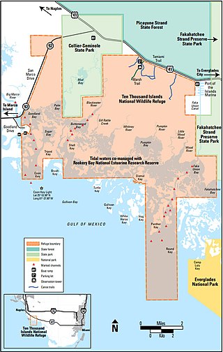
The Ten Thousand Islands are a chain of islands and mangrove islets off the coast of southwest Florida, between Cape Romano and the mouth of the Lostmans River. Some of the islands are high spots on a submergent coastline. Others were produced by mangroves growing on oyster bars. Despite the name, the islets in the chain only number in the hundreds.

<span class="mw-page-title-main">Key Marco</span> Archaeological site in Florida, US

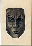
Key Marco was an archaeological site (8CR48) consisting of a large shell works island next to Marco Island, Florida. A small pond on Key Marco, now known as the "Court of the Pile Dwellers" (8CR49), was excavated in 1896 by the Smithsonian Institution's Pepper-Hearst Expedition, led by Frank Hamilton Cushing. Cushing recovered more than 1,000 wooden artifacts from the pond, the largest number of wooden artifacts from any prehistoric archaeological site in the eastern United States. These artifacts are described as some of the finest prehistoric Native American art in North America. The Key Marco materials are principally divided between the University of Pennsylvania Museum of Archaeology and Anthropology, University of Pennsylvania; the Department of Anthropology, National Museum of Natural History, Smithsonian Institution; and the Florida Museum of Natural History, University of Florida. The original pond was completely excavated and refilled. It is now covered by a housing subdivision. Excavations of small parts of the site were also conducted in 1965 and 1995.

<span class="mw-page-title-main">Horr's Island</span> Archaeological site in Florida, US

Horr's Island is a significant Archaic period archaeological site located on an island in Southwest Florida formerly known as Horr's Island. Horr's Island is on the south side of Marco Island in Collier County, Florida. The site includes four mounds and a shell ring. It has one of the oldest known mound burials in the eastern United States, dating to about 3400 radiocarbon years Before Present (BP). One of the mounds has been dated to as early as 6700 BP. It was the largest known community in the southeastern United States to have been permanently occupied during the Archaic period.

The Caloosahatchee culture is an archaeological culture on the Gulf coast of Southwest Florida that lasted from about 500 to 1750 AD. Its territory consisted of the coast from Estero Bay to Charlotte Harbor and inland about halfway to Lake Okeechobee, approximately covering what are now Charlotte, Lee, and Collier counties. At the time of first European contact, the Caloosahatchee culture region formed the core of the Calusa domain.

Mound Key Archaeological State Park is a Florida State Park, located in Estero Bay, near the mouth of the Estero River. One hundred and thirteen of the island's one hundred and twenty-five acres are managed by the park system. It is a complex of mounds and accumulated shell, fish bone, and pottery middens that rises more than 30 feet above the waters of the bay.

The Big Mound Key-Boggess Ridge Archeological District is a historic site near Placida, Florida. It is located southeast of Placida, on Big Mound Key. On December 3, 1990, it was added to the U.S. National Register of Historic Places.

The Garden Patch is a Middle Woodland archaeological site in Horseshoe Cove, near Horseshoe Beach, Florida, off County Road 351. For a major part of its occupation, the site was a ceremonial center associated with the Swift Creek and Weeden Island cultures. On April 25, 1991, it was added to the U.S. National Register of Historic Places.

The Pineland Archeological District is a U.S. historic district located on Pine Island, near Pineland, Florida, and next to Pine Island Sound. The site was occupied by people of the Caloosahatchee culture, known as the Calusa in historic times, from 500 BCE until after 1700. The site includes shell and sand mounds and other structures and prehistoric canals and artificial lakes. It also includes structures from the late 19th and early 20th centuries.

Useppa Island is an island located near the northern end of Pine Island Sound in Lee County, Florida, United States. It has been known for luxury resorts since the late 19th century, and it is currently the home of the private Useppa Island Club. On May 21, 1996, it was added to the U.S. National Register of Historic Places, due to its archaeological significance.

<span class="mw-page-title-main">St. Johns culture</span> Archaeological culture in North America

The St. Johns culture was an archaeological culture in northeastern Florida, USA that lasted from about 500 BCE until shortly after European contact in the 17th century. The St. Johns culture was present along the St. Johns River and its tributaries (including the Oklawaha River, and along the Atlantic coast of Florida from the mouth of the St. Johns River south to a point east of the head of the St. Johns River, near present-day Cocoa Beach, Florida. At the time of first European contact, the St. Johns culture area was inhabited by speakers of the Mocama, Agua Fresca and Acuera dialects of the Timucua language and by the Mayacas.

Fort Center is an archaeological site in Glades County, Florida, United States, a few miles northwest of Lake Okeechobee. It was occupied for more than 2,000 years, from 450 BCE until about 1700 CE. The inhabitants of Fort Center may have been cultivating maize centuries before it appeared anywhere else in Florida.

<span class="mw-page-title-main">Shell ring</span> Type of shell mound

Shell rings are archaeological sites with curved shell middens completely or partially surrounding a clear space. The rings were sited next to estuaries that supported large populations of shellfish, usually oysters. Shell rings have been reported in several countries, including Colombia, Peru, Japan, and the southeastern United States. Archaeologists continue to debate the origins and use of shell rings.

<span class="mw-page-title-main">Shell works</span> Complex constructions of mollusc shells

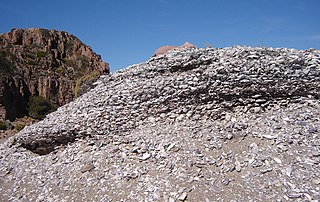
Shell works are large and complex assemblages of shell found in southwest Florida. Shell works include mounds and other deposits, with features described as borrow pits, canals, causeways, cisterns, crescents, sunken plazas, ponds, ramps, raised platforms, ridges, rings, walls, and "water courts". The largest shell works were constructed during the Woodland period in southwest Florida, from Charlotte Harbor to the Ten Thousand Islands, including Estero Bay.

Cayo Pelau Archaeological Site is a multi-period aboriginal archaeological site in Charlotte Harbor on the west peninsular Gulf coast of the United States. The island is 3.5 miles directly south of the Big Mound Key-Boggess Ridge Archeological District. It is the only site that lies within two counties, Lee County in the south and Charlotte County, Florida to the north. Neither county has taken responsibility for identifying, protecting or preserving the prehistoric and historical cultural resources on the island.

The Roberts Island complex is an archaeological site in Citrus County, Florida, near the Gulf of Mexico, dating from the late Woodland period. It is located on an island in the Crystal River midway between the springs at the head of the river and the mouth of the river on the Gulf of Mexico. The site is a geographically separate unit of the Crystal River Archaeological State Park. The site includes three shell mounds and three middens. Two of the mounds may have had stepped sides. The Roberts Island complex was developed as the Crystal River site declined and most other ceremonial sites in the region were abandoned during the 7th or 8th century.

References