
The Everglades is a natural region of flooded grasslands in the southern portion of the U.S. state of Florida, comprising the southern half of a large drainage basin within the Neotropical realm. The system begins near Orlando with the Kissimmee River, which discharges into the vast but shallow Lake Okeechobee. Water leaving the lake in the wet season forms a slow-moving river 60 miles (97 km) wide and over 100 miles (160 km) long, flowing southward across a limestone shelf to Florida Bay at the southern end of the state. The Everglades experiences a wide range of weather patterns, from frequent flooding in the wet season to drought in the dry season. Throughout the 20th century, the Everglades suffered significant loss of habitat and environmental degradation.

Chokoloskee is an unincorporated community and census-designated place (CDP) located at the edge of the Ten Thousand Islands in Collier County, Florida, United States. The population was 345 at the 2020 census, down from 359 at the 2010 census. It is part of the Naples–Marco Island Metropolitan Statistical Area.

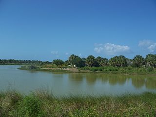
Everglades City is a city in Collier County, Florida, United States, of which it was once the county seat. The City of Everglades City is part of the Naples–Marco Island Metropolitan Statistical Area, which is included in the Cape Coral-Fort Myers-Naples Combined Statistical Area. The Gulf Coast Visitor Center for Everglades National Park is located in Everglades City. As of the 2020 US census, the population was 352, down from 400 in the 2010 US census.

Flamingo is the southernmost headquarters of Everglades National Park, in Monroe County, Florida, United States. Flamingo is one of the two end points of the 99-mile (159-km) Wilderness Waterway, and the southern end of the only road through the park from Florida City. It began as a small coastal settlement on the eastern end of Cape Sable on the southern tip of the Florida peninsula, facing Florida Bay. The actual town of Flamingo was located approximately 4+1⁄2 miles west of the current Flamingo campground area. All that remains of the former town are a few remnants of building foundations, and it is considered a ghost town.

Everglades National Park is an American national park that protects the southern twenty percent of the original Everglades in Florida. The park is the largest tropical wilderness in the United States and the largest wilderness of any kind east of the Mississippi River. An average of one million people visit the park each year. Everglades is the third-largest national park in the contiguous United States after Death Valley and Yellowstone. UNESCO declared the Everglades & Dry Tortugas Biosphere Reserve in 1976 and listed the park as a World Heritage Site in 1979, and the Ramsar Convention included the park on its list of Wetlands of International Importance in 1987. Everglades is one of only three locations in the world to appear on all three lists.

The Suwannee River is a river that runs through south Georgia southward into Florida in the Southern United States. It is a wild blackwater river, about 246 miles (396 km) long. The Suwannee River is the site of the prehistoric Suwanee Straits that separated the Florida peninsula from the Florida panhandle and the rest of the continent.
Pelican Island National Wildlife Refuge is a United States National Wildlife Refuge (NWR), and part of the Everglades Headwaters NWR complex, located just off the western coast of North Hutchinson Island in the Indian River Lagoon east of Sebastian, Florida. The refuge consists of a 3-acre (12,000 m2) island that includes an additional 2.5 acres (10,000 m2) of surrounding water and is located off the east coast of Florida of the Indian River Lagoon. Established by an executive order of President Theodore Roosevelt on March 14, 1903, Pelican Island was the first National wildlife refuge in the United States. It was created to protect egrets and other birds from extinction through plume hunting. The oldest government wildlife refuge of any kind in North America is the Lake Merritt Bird Refuge in Oakland, California. Oakland Mayor Samuel Merritt declared it a wildlife refuge for migrating birds in 1869. In 1870, the state of California designated Lake Merritt a state game refuge.
Cape Sable is the southernmost point of the United States mainland and mainland Florida. It is located in southwestern Florida, in Monroe County, and is part of the Everglades National Park.

Horr's Island is a significant Archaic period archaeological site located on an island in Southwest Florida formerly known as Horr's Island. Horr's Island is on the south side of Marco Island in Collier County, Florida. The site includes four mounds and a shell ring. It has one of the oldest known mound burials in the eastern United States, dating to about 3400 radiocarbon years Before Present (BP). One of the mounds has been dated to as early as 6700 BP. It was the largest known community in the southeastern United States to have been permanently occupied during the Archaic period.

The Florida Panther National Wildlife Refuge is part of the United States National Wildlife Refuge System, located in southwestern Florida, twenty miles east of Naples, in the upper segment of the Fakahatchee Strand of the Big Cypress Swamp. It is north of I-75 and west of SR 29.

Shark Valley is a geological depression at the head of the Shark River Slough in far western Miami-Dade County, Florida, United States. It is currently part of Everglades National Park. Shark Valley empties into Shark River in the Ten Thousand Islands of Monroe County. Shark Valley characteristically includes sawgrass prairie that floods during the rainy season, hence the name "river of grass"—Pa-Hay-Okee, from the Mikasuki language—for such marshes in the Everglades. Shark Valley features a Visitor Center with educational displays, a park video, an underwater camera and informational brochures. The entrance to Shark Valley is located along Tamiami Trail near the Miami-Dade–Collier County line.
Dismal Key is a small island, part of the Ten Thousand Islands archipelago in the Gulf of Mexico off the coast of Florida. The island is artificial, constructed by people of the Glades culture. Construction of the island proceeded in stages over some 1,500 years following the end of the Archaic period in Florida. Occupation probably ended a couple of centuries before the arrival of Europeans in Florida. Dismal Key was occupied by several hermits in the 20th century.
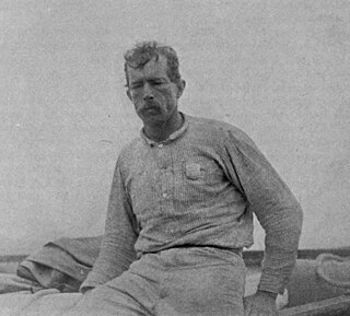
Guy Morrell Bradley was an American game warden and deputy sheriff for Monroe County, Florida. Born in Chicago, Illinois, he relocated to Florida with his family when he was young. As a boy, he often served as guide to visiting fishermen and plume hunters, although he later denounced poaching after legislation was passed to protect the dwindling number of birds. In 1902, Bradley was hired by the American Ornithologists' Union, at the request of the Florida Audubon Society, to become one of the country's first game wardens.
The indigenous people of the Everglades region arrived in the Florida peninsula of what is now the United States approximately 14,000 to 15,000 years ago, probably following large game. The Paleo-Indians found an arid landscape that supported plants and animals adapted to prairie and xeric scrub conditions. Large animals became extinct in Florida around 11,000 years ago.

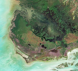
Before drainage, the Everglades, a region of tropical wetlands in southern Florida, were an interwoven mesh of marshes and prairies covering 4,000 square miles (10,000 km2). The Everglades is both a vast watershed that has historically extended from Lake Okeechobee 100 miles (160 km) south to Florida Bay, and many interconnected ecosystems within a geographic boundary. It is such a unique meeting of water, land, and climate that the use of either singular or plural to refer to the Everglades is appropriate. When Marjory Stoneman Douglas wrote her definitive description of the region in 1947, she used the metaphor "River of Grass" to explain the blending of water and plant life.

The Ten Thousand Islands National Wildlife Refuge is located in Southwest Florida in Collier County, between Marco Island and Everglades City, Florida. The refuge was first established in 1996 and covers 35,000 acres of the Ten Thousand Islands. The refuge includes both fresh and saltwater, and protects a large area of mangrove forest.
Plume hunting is the hunting of wild birds to harvest their feathers, especially the more decorative plumes which were sold for use as ornamentation, particularly in hat-making (millinery). The movement against the plume trade in the United Kingdom was led by Etta Lemon, Eliza Phillips, Emily Williamson, and other women and led to the establishment of the Royal Society for the Protection of Birds. The feather trade was at its height in the late 19th and was brought to an end in the early 20th century.

The Everglades Wilderness Waterway is a 99-mile navigable recreational waterway route within Everglades National Park, also known as Marjory Stoneman Douglas Wilderness. It includes many interconnecting creeks, rivers, lakes and inner bays that are navigable by shallow draft powerboat, kayak or canoe. The official Wilderness Waterway route is 99 miles long, but a traveler can use various additional route options to greatly extend or slightly shorten the trip.

Poinciana was a planned community that was to be located along the Lostmans River in Monroe County, Florida. Poinciana has been described as the Everglades's "most spectacular commercial enterprise" and "the prototype of all Florida scams".


