Kangaroo Valley, New South Wales

Last updated

Kangaroo Valley
New South Wales
Kangaroo Valley, main street.jpg
Main street of Kangaroo Valley, 2006
Australia New South Wales location map blank.svg
Red pog.svg
Kangaroo Valley
Coordinates 34°44′S150°32′E / 34.733°S 150.533°E / -34.733; 150.533 Coordinates: 34°44′S150°32′E / 34.733°S 150.533°E / -34.733; 150.533
Population879 (2016 census) [1]
 • Density3.434/km2 (8.893/sq mi)
Established1817
Elevation86 m (282 ft)
Area256 km2 (98.8 sq mi)
Time zone AEST (UTC+10)
 • Summer (DST) AEDT (UTC+11)
Location
LGA(s) City of Shoalhaven
Region Southern Highlands
County Camden
Parish Cambewarra
State electorate(s) Kiama
Federal division(s) Gilmore
Suburbs around Kangaroo Valley:
Meryla Barrengarry Upper Kangaroo River
Meryla Kangaroo Valley Wattamolla
Moollattoo Red Rocks Beaumont

Kangaroo Valley is a river valley along the Kangaroo River in the Shoalhaven region of New South Wales, Australia, located west of the seaside in the City of Shoalhaven. [2] It is also the name of the small suburb within it, formerly known as Osborne, with a population of 879 in the 2016 census. [1] The township is accessed by the Moss Vale Road, which links Moss Vale to the Princes Highway at Bomaderry a little north of Nowra via the B73 route.

Contents

General

As of 2013, the small town has a variety of arts and craft shops, restaurants and cafes, a hotel, club, post office, supermarket and other businesses, including an ambulance station, general practitioner and a chemist.

Kangaroo Valley has a bus service to/from Nowra or Moss Vale. Kennedy's Bus Company operates to Kangaroo Valley via Cambewarra.

Events held in the town include the Kangaroo Valley Agricultural and Horticultural Show in February each year, Kangaroo Valley Folk Festival in October each year, biannually the Kangaroo Valley Arts Festival and monthly markets at Kangaroo Valley Village Markets. [3]

History

The first inhabitants of Kangaroo Valley were the Australian Aboriginal Wodi-Wodi people, who had reportedly occupied the land for around 20,000 years before the European settlement of Australia in 1788. An 1826 census indicated 79 Aborigines lived in the valley in five separate encampments. [4] The first recorded European sighting of the valley was in April 1812, when surveyor-explorer George Evans passed through the area as he travelled north from his exploration of Jervis Bay. Evans reportedly claimed that the valley offered a view that "no painter could beautify." [5]

The area was first settled in 1817 when Charles Throsby, an explorer and Captain Richard Brooks, a cattleman, opened the area for colonial settlement. The felling and exporting of Australian Red Cedar (Toona ciliata) trees quickly became the main industry in Kangaroo Valley. By the mid-1840s, a number of dairy farmers made the region their home, specialising in the production of butter as other dairy products such as milk couldn't be exported as they would often curdle long before they had completed the treacherous journey out of Kangaroo Valley to neighbouring settlements.

By the 1870s, activity had begun to concentrate in the area that is now the village, as other centres in Kangaroo Valley, such as Trendally, died with the dairy industry in the region. Both the Church of the Good Shepherd (built in 1870–72) and rectory (built in 1879 by John Tanner) were designed by John Horbury Hunt, and are listed on the (now defunct) Register of the National Estate. [6]

The local public school was built in 1884 of local sandstone. Further additions constructed of weatherboard and brick were made later. The local courthouse was built c.1910, also of local sandstone. The design is asymmetrical and features a sloping buttress and arch. The main buildings include a residence and lock-up as well as the courthouse itself. Alterations and extensions have taken place over the years. The local school and the courthouse are both listed on the Register of the National Estate. [6]

The valley has changed very little in the past 130 years with reminders such as the Hampden Bridge, completed in 1898, and the oldest suspension bridge in Australia, and old Barrengarry School serving as a testimony to the past when Kangaroo Valley was home to a flourishing dairy industry. Agriculture still exists, though other industries such as tourism and outdoor recreation have since taken over as the primary source of income.

Heritage listings

Kangaroo Valley has a number of heritage-listed sites, including:

Demographics

In the 2016 Census, there were 879 people in Kangaroo Valley. 69.7% of people were born in Australia and 88.5% of people spoke only English at home. The most common responses for religion in Kangaroo Valley were No Religion 35.1%, Anglican 21.4% and Catholic 14.3%. [1]

Geography

Kangaroo Valley is a gently sloping wide valley surrounded on its sides by high mountains of the NSW Southern Highlands, approximately two hours' drive south-west of Sydney and about two hours north of Canberra. Flying Fox Pass looks over the valley. A few kilometres further north is the Fitzroy Falls.

Cultural activities and events

The district has a strong artistic community and, since 2007, has mounted a biannual arts and music festival. In 2009, the festival celebrated the 80th birthday of Australian composer Peter Sculthorpe with three concerts devoted to his music. [8]

The annual Kangaroo Valley Folk Festival in October is presented by Shoalhaven Folk Club Inc with local, Australian and international performers. [9]

The historic township of Kangaroo Valley shares its secrets with a visit to the Pioneer Farm Museum where this historical settlement depicting farm life in the second half of the 19th and early 20th century is brought to life. Invigorating bushwalks are available at the back of the museum park including the Walker Suspension Bridge spanning 72 metres and leading to two marked bushwalks on more than seven hectares of natural reserve.

Education

Kangaroo Valley Public School is a genuine country school with a close knit community and supportive P&C Association. A small school, providing a happy, nurturing and quality educational experience for all its students. For many years, it has achieved and maintained an excellent standard in academic, sporting, community and cultural endeavours.

In addition to a local public primary school, The Scots College 200 acres (0.81 km2) Glengarry outdoor education campus for year-nine students is located in Kangaroo Valley, with five 20-bed dormitories, six classrooms, a gymnasium and a theatrette. The Scots College participates in several community events including the traffic stopping ANZAC Day March and Ceremony and the A&H Society Annual Show in February.

See also

Related Research Articles

<span class="mw-page-title-main">City of Shoalhaven</span> Local government in New South Wales, Australia

The City of Shoalhaven is a local government area in the south-eastern coastal region of New South Wales, Australia. The area is about 200 kilometres (120 mi) south of Sydney. The Princes Highway passes through the area, and the South Coast railway line traverses the northern section, terminating at Bomaderry. At the 2021 census, the population was 108,531.

<span class="mw-page-title-main">Milton, New South Wales</span> Town in New South Wales, Australia

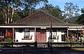
Milton is a village in the South Coast region of New South Wales, Australia, within the City of Shoalhaven. It was founded in 1860, named after the property of post master George Knight and became an important regional centre during the 19th Century. Today, Milton remains one of the two main commercial centres of the Milton-Ulladulla district, with a population at the 2016 census of 1,663. It is a popular stopping place for travellers on the Princes Highway which runs through the centre of town. In recent years, Milton has undergone a resurgence largely influenced by the local tourism industry and an influx of residents to the district seeking a seachange. Several new housing estates are being developed on the fringes of the village and new boutique stores, cafes and bed and breakfast type businesses have located in the town.

Berry is a small Australian village in the Shoalhaven region of the New South Wales South Coast, located 143 km (89 mi) south of the state capital, Sydney. It has many historical buildings which are listed on the New South Wales Heritage Register. Berry attracts many tourists who come to enjoy the diversity of landscapes, including coastal beaches, rich dairy farming, and forested mountains. The village hosts a local Produce Market which is held twice each month on the second Saturday and fourth Sunday. Together with Kiama 23 km (14 mi) to the north, Berry acts as a gateway through to other towns and villages along the South Coast of NSW via the Princes Highway and the South Coast railway line. Major highway building projects in and around Berry have now bypassed the village, creating uninterrupted motorway conditions for coastal travel south to Nowra and the South Coast and north to Wollongong and Sydney. This has resulted in the removal of all but local and visitor traffic within the village. Planning is underway to create a pedestrian-friendly precinct in and around Queens Street.

<span class="mw-page-title-main">Nowra</span> Town in New South Wales, Australia

Nowra is a city in the South Coast region of New South Wales, Australia. It is located 160 kilometres (99 mi) south-southwest of the state capital of Sydney. As of the 2021 census, Nowra has an estimated population of 22,584. Situated in the southern reaches of the Sydney basin, Nowra is the seat and commercial centre of the City of Shoalhaven.

<span class="mw-page-title-main">Bomaderry, New South Wales</span> Suburb of Shoalhaven, New South Wales, Australia

Bomaderry is a town in the Shoalhaven council district area of New South Wales, Australia. At the 2021 census, it had a population of 8,718 people. It is on the north shore of the Shoalhaven River, across the river from Nowra, the major town of the City of Shoalhaven, of which Bomaderry is locally regarded as being a suburb of the city.

<span class="mw-page-title-main">Shoalhaven River</span> River in Australia

The Shoalhaven River is a perennial river that rises from the Southern Tablelands and flows into an open mature wave dominated barrier estuary near Nowra on the South Coast of New South Wales, Australia.

<span class="mw-page-title-main">Gerringong, New South Wales</span> Town in New South Wales, Australia

Gerringong is a town located about ten minutes drive south of Kiama, and about twenty minutes north of Nowra in the Illawarra region of New South Wales, Australia in the Municipality of Kiama. At the 2016 census, Gerringong had a population of 3,966. One theory says that the name derives from an Aboriginal word meaning "fearful place".

<span class="mw-page-title-main">Kangaroo River (Shoalhaven)</span> River in New South Wales, Australia

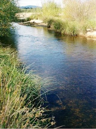
The Kangaroo River is a perennial river of the Shoalhaven catchment located in the Southern Highlands and Illawarra regions of New South Wales, Australia.

<span class="mw-page-title-main">Hampden Bridge, Kangaroo Valley</span> Bridge in New South Wales, Australia

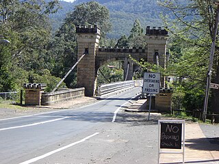
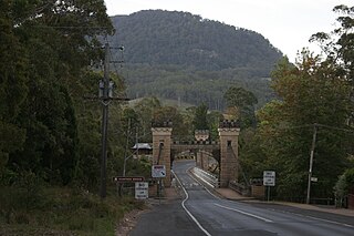
Hampden Bridge is a heritage-listed single-span suspension bridge that carries Moss Vale Road (B73) across the Kangaroo River, in Kangaroo Valley, in the City of Shoalhaven local government area of New South Wales, Australia. The bridge was designed by Ernest de Burgh and built by Loveridge and Hudson. The property is owned by Transport for NSW. It was added to the New South Wales State Heritage Register on 2 August 2019.

<span class="mw-page-title-main">South Coast (New South Wales)</span> Region in New South Wales, Australia

The South Coast refers to the narrow coastal belt from Shoalhaven district in the north to the border with Victoria in the south in the south-eastern part of the State of New South Wales, Australia. It is bordered to the west by the coastal escarpment of the Southern Tablelands, and is largely covered by a series of national parks, namely Jervis Bay National Park, Eurobodalla National Park, and Beowa National Park. To the east is the coastline of the Pacific Ocean, which is characterised by rolling farmlands, small towns and villages along a rocky coastline, interspersed by numerous beaches and lakes.

<span class="mw-page-title-main">Callala Bay</span> Town in New South Wales, Australia

Callala Bay is a small town on the South Coast of New South Wales, Australia in the City of Shoalhaven.

Avoca is a small town in the Southern Highlands of New South Wales, Australia, in Wingecarribee Shire.

Barrengarry is a small village near the Southern Highlands of New South Wales, Australia, in City of Shoalhaven. It is situated north of Kangaroo Valley. At the 2021 census, it had a population of 214.

Tomerong is a village in the South Coast region of New South Wales, Australia. It is located approximately 180 kilometres by road south from the state capital Sydney and 20 kilometres south of the commercial centre of the City of Shoalhaven, Nowra in the County of St Vincent. The village is eight kilometres inland of the western shores of Jervis Bay. Its population at the 2021 census was 1,194.

<span class="mw-page-title-main">Beaumont, New South Wales</span> Town in New South Wales, Australia

Beaumont is a locality in the City of Shoalhaven in New South Wales, Australia. It lies on Cambewarra Range about 18 km north of Nowra on both sides of the Kangaroo Valley–Nowra road. It includes the Cambewarra Mountain lookout, which gives a good view of the lower Shoalhaven valley. At the 2016 census, it had a population of 125.

<span class="mw-page-title-main">Cambewarra Village</span> Town in New South Wales, Australia

Cambewarra Village is a locality in the City of Shoalhaven in New South Wales, Australia. It lies on Main Road, which runs west from Cambewarra Road, which forms part of the Kangaroo Valley–Nowra road, about 9 km northwest of Nowra and south of Cambewarra Mountain. At the 2016 census, it had a population of 1,189. Cambewarra Village is largely surrounded by the locality of Cambewarra.

<span class="mw-page-title-main">Berry Mountain, New South Wales</span> Town in New South Wales, Australia

Berry Mountain is a locality in the City of Shoalhaven in New South Wales, Australia. It lies west of the Princes Highway on the Kangaroo Valley Road between Berry and Kangaroo Valley. It lies about 23 kilometre north of Nowra and about 160 km south of Sydney. At the 2016 census, it had a population of 28. It lies on a ridge and is partly covered by temperate rain forest and partly by grasslands that were formerly used for dairying, but are now mainly used for rural residences.

<span class="mw-page-title-main">Bellawongarah</span> Town in New South Wales, Australia

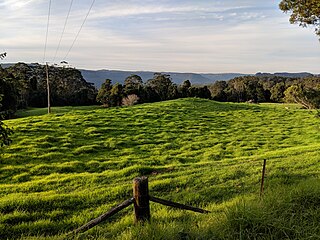
Bellawongarah is a locality in the City of Shoalhaven in New South Wales, Australia. It lies west of the Princes Highway on the Kangaroo Valley Road between Berry and Kangaroo Valley. It lies about 23 kilometre north of Nowra and about 160 km south of Sydney. At the 2016 census, it had a population of 127. It lies on a ridge and is partly covered by temperate rain forest and partly by grasslands that were formerly used for dairying, but are now mainly used for rural residences.

<span class="mw-page-title-main">Graham Lodge</span> Historic site in New South Wales, Australia

Graham Lodge is a heritage-listed former homestead, function centre and leagues club at Pleasant Way, Nowra, City of Shoalhaven, New South Wales, Australia. It was built from 1860 to 1861 by stonemason Charles Moore and carpenter Willet Burry. It was also known as Greenhills and Warragee during its homestead era, as Prague Lodge while it was a function centre, and later as the now-defunct Nowra Bomaderry Leagues Club. The property is owned by Shoalhaven City Council. It was added to the New South Wales State Heritage Register on 4 June 2004.

Cambewarra Shire was a local government area in the South Coast region of New South Wales, Australia.

References

  1. 1 2 3 Australian Bureau of Statistics (27 June 2017). "Kangaroo Valley (State Suburb)". 2016 Census QuickStats. Retrieved 10 July 2017. OOjs UI icon edit-ltr-progressive.svg
  2. "Kangaroo Valley". Geographical Names Register (GNR) of NSW. Geographical Names Board of New South Wales . Retrieved 9 August 2017. OOjs UI icon edit-ltr-progressive.svg
  3. "Kangaroo Valley". Visit NSW. Retrieved 30 March 2013.
  4. "Kangaroo Valley". The Sydney Morning Herald . 5 December 2007.
  5. "About Kangaroo Valley". Kangaroo Valley Tourist Association Inc. 2006.
  6. 1 2 The Heritage of Australia. Macmillan Company. 1981. pp. 2, 161.
  7. "Hampden Bridge". New South Wales State Heritage Register . Department of Planning and Environment. H02024. Retrieved 18 February 2020. CC-BY icon.svg Text is licensed by State of New South Wales (Department of Planning and Environment) under CC-BY 4.0 licence .
  8. "Kangaroo Valley". The Sydney Morning Herald. 5 May 2009. p. 10.
  9. "Kangaroo Valley Folk Festival". Kangaroo Valley Folk Festival. Retrieved 14 July 2015.