The Shoalhaven Scheme is a dual-purpose water supply and Pumped-storage Hydroelectricity scheme located on the South Coast region of New South Wales, Australia.
The Scheme was built as a joint project between the Electricity Commission of NSW and the NSW Metropolitan Water Sewerage and Drainage Board. Management has subsequently passed to Origin Energy and the Sydney Catchment Authority.
Water in the scheme is stored in three principal dams and their associated reservoirs: Tallowa Dam, Fitzroy Falls Dam and Wingecarribee Dam. Wingecarribee River is a tributary of Warragamba River, so water pumped into Wingecarribee Reservoir can be released into Warragamba Dam and hence the Sydney water supply. Water can also be released into Nepean Dam via a system of rock cuttings and tunnels known as Glenquarry Cut. Water from the Nepean Dam can be transferred to Sydney, or to Wollongong via Avon Dam.
In addition to its water supply capabilities which supplements water supplies to the Sydney area, the Shoalhaven Scheme also comprises two hydro-power facilities, with total generating capacity of 240 megawatts (320,000 hp). The flexibility of the scheme is that it can operate as either a pump or a generator. During off peak periods, it utilises excess electricity from the grid to pump water back up to the reservoir(s) as pumped storage. The two power stations are: [1] [2] The Kangaroo Valley and Bendeela power stations were completed in 1977 as a joint project between the Electricity Commission of New South Wales and the NSW Metropolitan Water Sewerage and Drainage Board. Management has subsequently been passed from those bodies to Origin Energy and the Sydney Catchment Authority. [1]
Kangaroo Valley Power Station in the Kangaroo Valley has two 80-megawatt (110,000 hp) pump turbines, for a total electricity generating capacity of 160 megawatts (210,000 hp). From Bendeela Pondage, the Kangaroo Valley Pumping and Power Station lifts water a further 480 metres (1,570 ft) to Fitzroy Falls Reservoir via a tunnel, shaft, pipeline, and canal. Water available for hydro-electric power generation is discharged back down the conduits, driving turbines as it returns to Bendeela Pondage and then Lake Yarrunga.
Bendeela Pondage, completed in 1972, is an earth and rockfill embankment dam structure located above the Bendeela Hydroelectric Pumped Storage Power Station on the Shoalhaven River / Kangaroo River which both go into the Tallowa Dam and the Kangaroo Valley Hydroelectric Pumped Storage Power Station. It's a small storage buffer dam for between the two Pumped-storage Hydroelectric Power Station's.
Bendeela Power Station has two 40-megawatt (54,000 hp) pump turbines, for a total of 80 megawatts (110,000 hp) of electricity generating capacity. Bendeela Pumping and Power Station, located on the Kangaroo River arm of Lake Yarrunga, lifts water 127 metres (417 ft) to Bendeela Pondage.
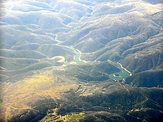
The Shoalhaven River and its main tributary the Kangaroo River. Tallowa Dam has been a barrier to migratory native fish with estuarine/marine juvenile stages, blocking species including Australian bass from more than 80% of their former range in the Shoalhaven system. Stockings of hatchery bred bass in Lake Yarrunga has been an attempt to remediate the situation.[ citation needed ] A fishway for Tallowa Dam has been discussed for more than 20 years but was not constructed until 2009. [3] Lake Yarrunga also contains exotic species such as carp, which are now present in high densities. A fish lift began operation in August 2009. [4]

Dartmouth Dam is a large rock-fill embankment dam with an uncontrolled chute spillway across the Mitta Mitta, Gibbo, and Dart rivers, the Morass Creek and a number of small tributaries. The dam is located near Mount Bogong in the north-east of the Australian state of Victoria. The dam's purpose includes irrigation, the generation of hydro-electric power, water supply and conservation. The impounded reservoir is called Dartmouth Reservoir, sometimes called Lake Dartmouth. The Dartmouth Power Station, a hydro-electric power station that generates power to the national grid, is located near the dam wall.

Hydroelectricity, or hydroelectric power, is electricity produced from hydropower. In 2015, hydropower generated 16.6% of the world's total electricity and 70% of all renewable electricity, and was expected to increase by about 3.1% each year for the next 25 years.

Warragamba Dam is a heritage-listed dam in the outer South Western Sydney suburb of Warragamba, Wollondilly Shire in New South Wales, Australia. It is a concrete gravity dam, which creates Lake Burragorang, the primary reservoir for water supply for the city of Sydney. The dam wall is located approximately 65 kilometres (40 mi) to the southwest of Sydney central business district, near the town of Wallacia.

Lake Burragorang is an Australian man-made reservoir created by a dam, serving as a major water supply for greater metropolitan Sydney and located in the lower Blue Mountains of New South Wales. The dam impounding the lake, the Warragamba Dam, is located approximately 60 kilometres (37 mi) southwest of the Sydney central business district.

The Eildon Dam or Eildon Weir, a rock and earth-fill embankment dam with a controlled spillway across the Goulburn River, is located between the regional towns of Mansfield and Eildon within Lake Eildon National Park, in the Alpine region of Victoria, Australia. The dam's purpose is for the supply of potable water, irrigation, and the generation of hydroelectricity. The impounded reservoir is called Lake Eildon.

The Murray Region Hydroelectric Power Stations refers to two of the original seven hydroelectric power stations, both located near the town of Khancoban in the Snowy Mountains region of New South Wales, Australia. The two power stations are part of the Snowy Mountains Scheme, a vast hydroelectricity and irrigation complex constructed in south-east Australia between 1949 and 1974 and now run by Snowy Hydro. Although both power stations are physically located in New South Wales, since 1 July 2008 all power generated has been allocated to the Victorian region of the National Electricity Market. The stations are not located on the Murray River.
Tumut Hydroelectric Power Station is a series of three of the original four, now five hydroelectric power stations on the Tumut River in New South Wales, Australia, that are part of the Snowy Mountains Scheme.

The Rubicon Hydroelectric Scheme is a small run-of-the-river hydroelectric scheme located on the Rubicon and Royston Rivers, north east of Melbourne, 40 km (25 mi) south-west of Alexandra, Victoria, Australia. The scheme commenced in 1922, and was the first state-owned hydroelectric scheme to generate electricity in mainland Australia, and among the first in the world to be remotely controlled. For the first ten years of its operation it supplied on average 16.9% of electricity generated by the State Electricity Commission of Victoria. It is now owned and operated by AGL Energy and contributes approximately 0.02% of Victoria's energy supply.
Run-of-river hydroelectricity (ROR) or run-of-the-river hydroelectricity is a type of hydroelectric generation plant whereby little or no water storage is provided. Run-of-the-river power plants may have no water storage at all or a limited amount of storage, in which case the storage reservoir is referred to as pondage. A plant without pondage is subject to seasonal river flows, thus the plant will operate as an intermittent energy source. Conventional hydro uses reservoirs, which regulate water for flood control, dispatchable electrical power, and the provision of fresh water for agriculture.

Talbingo Dam is a major ungated rock fill with clay core embankment dam with concrete chute spillway across the Tumut River upstream of Talbingo in the Snowy Mountains region of New South Wales, Australia. The impounded reservoir is called Talbingo Reservoir.
Tumut Pond Dam is a major ungated concrete arch dam across the upper reaches of the Tumut River in the Snowy Mountains of New South Wales, Australia. The dam's main purpose is for the generation of hydro-power and is one of the sixteen major dams that comprise the Snowy Mountains Scheme, a vast hydroelectricity and irrigation complex constructed in south-east Australia between 1949 and 1974 and now run by Snowy Hydro.

Richard B. Russell Dam is a concrete-gravity and embankment dam located on the Savannah River at the border of South Carolina and Georgia, creating Richard B. Russell Lake. The dam was built by the U.S. Army Corps of Engineers between 1974 and 1985 for the purposes of flood control, hydroelectricity, recreation, additional stream flow regulation, water supply, and fish and wildlife management. The concrete structure of the dam spans 1,904 feet (580 m) and rises 210 feet (64 m) above the riverbed, housing a hydro-power plant with an installed 600 megawatts (800,000 hp) capacity. The Richard B. Russell Dam is the final large dam completed by the U.S. Army Corps in the Savannah River Basin and lies 30 miles downstream from the Hartwell Dam (1962) and 37 miles (60 km) upstream from the J. Strom Thurmond Dam (1954).

The Cruachan Power Station is a pumped-storage hydroelectric power station in Argyll and Bute, Scotland. The scheme can provide 440 MW of power and has a capacity of 7.1 GWh.

The Shin-Takasegawa Pumped Storage Station (新高瀬川発電所) uses the Takase River to operate a pumped storage hydroelectric scheme about 12 kilometres (7.5 mi) west of Ōmachi in Nagano Prefecture, Japan. Part of the system is within Chūbu-Sangaku National Park.
The Minghu Dam (Chinese: 明湖水壩; pinyin: Mínghú Shuǐbà, renamed the Takuan Dam, is a concrete gravity dam on the Shuili River located 7 km north of Shuili Township in Nantou County, Taiwan. The reservoir formed by the dam serves as the lower reservoir for the Minhu Pumped Storage Hydro Power Station. Sun Moon Lake serves as the upper reservoir.

Tumut Two Dam or Tumut Two is a major ungated concrete gravity dam across the upper reaches of the Tumut River in the Snowy Mountains of New South Wales, Australia. The dam's main purpose is for the generation of hydro-power and is one of the sixteen major dams that comprise the Snowy Mountains Scheme, a vast hydroelectricity and irrigation complex constructed in south-east Australia between 1949 and 1974 and now run by Snowy Hydro.
Guthega Dam is concrete gravity dam with an uncontrolled spillway across the Snowy River in the Snowy Mountains of New South Wales, Australia. The dam's main purpose is for the storage of water used in the generation of hydro-power. It is the first to be completed of the sixteen major dams of the Snowy Mountains Scheme, a vast hydroelectricity and irrigation complex constructed in south-east Australia between 1949 and 1974 and now run by Snowy Hydro.
Murray Two Dam or Murray 2 Dam is a major ungated concrete arch dam with a controlled spillway across Khancoban Bank, a diverted flow of the Snowy and Geehi rivers in the Snowy Mountains region of New South Wales, Australia. The impounded reservoir is called the Murray Two Pondage or Murray 2 Pondage.

Bendeela Pondage, completed in 1972, is an earth and rockfill embankment dam structure located on the Kangaroo River arm of Lake Yarrunga in New South Wales, Australia. It is located between Fitzroy Falls Dam and Tallowa Dam. The pondage, part of the Shoalhaven Scheme, functions as a buffer storage for out-of-balance flow between the two dams during hydro-electric power generation or water pumping at Kangaroo Valley and Bendeela pumping and power stations. The dam has no significant catchment but has been provided with a weir type spillway to protect the dam in the event of operational problems at the two pumping and power stations. The embankment is 15 metres (49 ft) high and 2,118 metres (6,949 ft) in length. At 100% capacity, the dam wall holds back approximately 1,200 megalitres.

Fitzroy Falls Dam in New South Wales, Australia, is part of the Shoalhaven Scheme, completed in 1974. It consists of four separate earth and rockfill embankments located on the Yarrunga Creek upstream of Fitzroy Falls and about 16 kilometres (9.9 mi) southeast of Moss Vale. The main embankment of 760 cubic metres (27,000 cu ft) is 14 metres (46 ft) high and 1,530 metres (5,020 ft) in length. At 100% capacity, the dam wall holds back approximately 9,950 megalitres of water, creating the impounded Fitzroy Falls Reservoir, which has a surface area of 522 hectares, drawn from a catchment area of 31 square kilometres (12 sq mi). The spillway has a discharge capacity of 516 cubic metres per second (18,200 cu ft/s).