Kurdistan, or Greater Kurdistan, is a roughly defined geo-cultural region in West Asia wherein the Kurds form a prominent majority population and the Kurdish culture, languages, and national identity have historically been based. Geographically, Kurdistan roughly encompasses the northwestern Zagros and the eastern Taurus mountain ranges.

Tehran province is one of the 31 provinces of Iran. It covers an area of 18,814 square kilometres (7,264 sq mi) and is located to the north of the central plateau of Iran.
Hamadan province is an Iranian province located in the Zagros Mountains. Its capital is the city of Hamadan. The province covers an area of 19,546 km2. According to the National Census held in 2006, Hamadan had a population of 1,674,595 in 427,675 households. The following census in 2011 counted 1,758,268 people in 506,191 households. In 2014, Hamadan province was placed in Region 4. The latest census in 2016 revealed a slight decrease in the population to 1,738,234 in 538,803 households.

Ardabil Province is one of the 31 provinces of Iran. It is in the northwest of the country, in Region 3, bordering the Republic of Azerbaijan, and the provinces of East Azerbaijan, Zanjan, and Gilan. Its administrative centre is the city of Ardabil. The province, spanning an area of 18,011 km2, and established in 1993, was carved out of the eastern part of East Azerbaijan.

Hormozgan Province is one of the 31 provinces of Iran. It is in the south of the country, in Iran's Region 2, facing Oman, the United Arab Emirates and the Hormuz Straits. Its area is 70,697 km2 (27,296 sq mi), and its provincial capital is Bandar Abbas. The province has fourteen islands in the Persian Gulf and 1,000 km (620 mi) of coastline.
Kurdistan or Kordestan province is one of the 31 provinces of Iran. The province is 28,817 km2 in area and its capital is the city of Sanandaj. Other counties with their major cities are Saqqez, Baneh, Marivan, Qorveh, Bijar, Kamyaran, Dehgolan, Diwandarreh and Sarvabad.
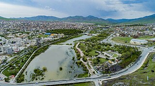
Saqqez, also known as Saghez, Saqez, Saqqiz, Saqiz, and Sakīz, is a city in the Central District of Saqqez County, Kurdistan province, Iran, and serves as both capital of the district and of the county.
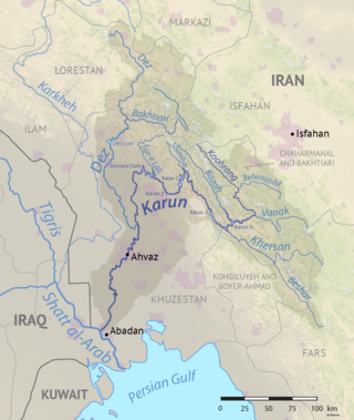
The Karun is the Iranian river with the highest water flow, and the country's only navigable river. It is 950 km (590 mi) long. The Karun rises in the Zard Kuh mountains of the Bakhtiari district in the Zagros Range, receiving many tributaries, such as the Dez and the Kuhrang. It passes through the capital of the Khuzestan Province of Iran, the city of Ahvaz, before emptying to its mouth into Arvand Rud.
The Little Zab or Lower Zab is a river that originates in Iran and joins the Tigris just south of Al Zab in the Kurdistan region of Iraq. The Little Zab is approximately 400 kilometres (250 mi) long and drains an area of about 22,000 square kilometres (8,500 sq mi). The river is fed by rainfall and snowmelt, resulting in a peak discharge in the spring and low water in the summer and early fall. Two dams built on the Little Zab regulate the river flow, providing water for irrigation and generating hydroelectricity. The Zagros Mountains have been populated since at least the Lower Palaeolithic, but the earliest archaeological site in the Little Zab basin, Barda Balka, dates to the Middle Palaeolithic. Human occupation of the Little Zab basin has been attested for every period since then.

Miandoab County is in West Azerbaijan province, Iran. Its capital is the city of Miandoab.
The Zangmar is a river in Maku County, West Azarbaijan Province, Iran. It originates in the Zagros Mountains above Maku, Iran along the Iran–Turkey border, not far from Mount Ararat and flows south and east into the Araxes at the town of Pol Dasht.

The Zarrineh Rud is a river in Kurdistan Province and West Azarbaijan Province, Iran.
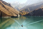
Azad Dam is an embankment dam on the Gura River, 40 km (25 mi) west of Sanandaj in Kordestan province, Iran. It is situated in Kurdistan Province and its construction is part of a water management plan for Kurdistan Province. It has an installed electricity generating capacity of 10 MW (13,000 hp) and future pumped storage power plant with a regenerating capacity of 500 MW (670,000 hp).

Mahabad Dam is an embankment dam on the Mahabad River near the city of Mahabad, West Azerbaijan province, Iran. It was built before the Islamic revolution by Yugoslavian engineers and is one of the ten largest dams in Iran. On average, the total volume of annual water input is equal to 339.304 million cubic meters. The Mahabad Dam provides water for agriculture (71%), industry (11%), drinking (7%), and other miscellaneous purposes (11%). The dam also has a hydroelectric power station. Construction began in 1968 and the dam was completed in 1970.

The Simineh River, also known as the Tatavi Chay, is a river in northern Iran, arising in the Zagros Mountains of Kurdistan Province north of Saqqez, that flows into the south end of Lake Urmia. It is just over 200 kilometres (124 mi) long and has a catchment basin (watershed) of 2,090 square kilometres (810 sq mi). Its waters are used primarily for agriculture and the return flow significantly degrades its water quality.
The Ghezel Ozan is one of the longest rivers in Iran, originating from the Chehel Cheshmeh Mountains between Saqqez and Divandarreh in Kurdistan Province flowing in northern Iran.
The Saqqez River is located in northwestern Iran and originates from the mountains west of Saqqez.
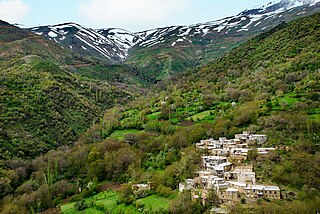
Mount ChlChama is a part of the Zagros mountains, which are located in Iran, between the cities of Saqqez, Divandarreh and Marivan in Kurdistan province. The highest peak of Chlchama, also known as Chlchama, is 3,173 metres above sea level, near the villages of Isakawa and Kanemat, 56 kilometres southwest of Saqqez.