Hoover Dam is a concrete arch-gravity dam in the Black Canyon of the Colorado River, on the border between the U.S. states of Nevada and Arizona. Constructed between 1931 and 1936, during the Great Depression, it was dedicated on September 30, 1935, by President Franklin D. Roosevelt. Its construction was the result of a massive effort involving thousands of workers, and cost over 100 lives. In bills passed by Congress during its construction, it was referred to as the Hoover Dam, after President Herbert Hoover, but was named the Boulder Dam by the Roosevelt administration. In 1947, the name Hoover Dam was restored by Congress.
Chat or chats may refer to:

A dam is a barrier that stops or restricts the flow of surface water or underground streams. Reservoirs created by dams not only suppress floods but also provide water for activities such as irrigation, human consumption, industrial use, aquaculture, and navigability. Hydropower is often used in conjunction with dams to generate electricity. A dam can also be used to collect or store water which can be evenly distributed between locations. Dams generally serve the primary purpose of retaining water, while other structures such as floodgates or levees are used to manage or prevent water flow into specific land regions.

The Diyala is a river and tributary of the Tigris. It is formed by the confluence of the Sirwan and Tanjaro rivers in Darbandikhan Dam in the Sulaymaniyah Governorate of Northern Iraq. It covers a total distance of 445 km (277 mi).
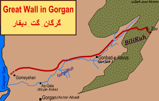
The Great Wall of Gorgan is a Sasanian-era defense system located near modern Gorgan in the Golestān Province of northeastern Iran, at the southeastern corner of the Caspian Sea. The western, Caspian Sea, end of the wall is near the remains of the fort at: 37.13981°N 54.1788733°E; the eastern end of the wall, near the town of Pishkamar, is near the remains of the fort at: 37.5206739°N 55.5770498°E. The title coordinate is for the location of the remains of a fort midway along the wall.

Andimeshk is a city in the Central District of Andimeshk County, Khuzestan province, Iran, serving as capital of both the county and the district. The city is about 34 kilometres (21 mi) north of Shush, on the main road and the rail line between Tehran and Ahvaz.
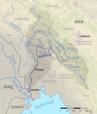
The Karun is the Iranian river with the highest water flow, and the country's only navigable river. It is 950 km (590 mi) long. The Karun rises in the Zard Kuh mountains of the Bakhtiari district in the Zagros Range, receiving many tributaries, such as the Dez and the Kuhrang. It passes through the capital of the Khuzestan Province of Iran, the city of Ahvaz, before emptying to its mouth into Arvand Rud.
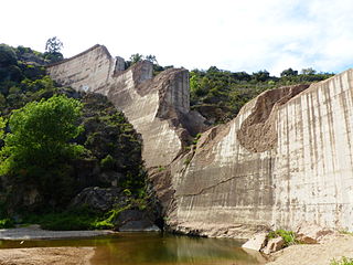
The Malpasset Dam was an arch dam on the Reyran River, north of Fréjus on the French Riviera. It collapsed on 2 December 1959, killing 423 people in the resulting flood. The breach was caused by a tectonic fault in the impermeable rock base, which had been inadequately surveyed. Nearby road-building works, using explosives, may also have contributed to the disaster.

The Ware River is a 35.4-mile-long (57.0 km) river in central Massachusetts. It has two forks, its West Branch, which begins in Hubbardston, Massachusetts, and its East Branch, which begins in Westminster, Massachusetts. The Ware River flows southwest through the middle of the state, joins the Quaboag River at Three Rivers, Massachusetts, to form the Chicopee River on its way to the Connecticut River.

An embankment dam or caldera is a large artificial dam. It is typically created by the placement and compaction of a complex semi-plastic mound of various compositions of soil or rock. It has a semi-pervious waterproof natural covering for its surface and a dense, impervious core. This makes the dam impervious to surface or seepage erosion. Such a dam is composed of fragmented independent material particles. The friction and interaction of particles binds the particles together into a stable mass rather than by the use of a cementing substance.
The Sumbar is a fast flowing river in southern Turkmenistan and northern Iran. It a tributary of the Atrek. The name Sari-su means yellow water in Turkic languages, but is applied to a number of other rivers as well. It used to be an area for Caspian tigers in Turkmenistan, until the last individual was killed in January 1954.

Qal'eh Bozi is a complex of caves sites located about 25 km (15.5 mi) south-southwest of Isfahan, Iran; northeast of Dizicheh and north of Hassanabad. The sites include two rock shelters and a cave located at altitudes between 1,750 and 1,810 m above sea level. The caves are found on the southern face of a limestone mountain of lower Cretaceous age that rises to more than 500 m (1,640.4 ft) above the plain floor. From the cave entrance there is a commanding view of the plain below and of the Zaiandeh Rud River flowing about 2 km (1.2 mi) to the south and southeast.

The Siah Bisheh Pumped Storage Power Plant, also spelled Siyāhbisheh and Siah Bishe, is located in the Alborz Mountain range near the village of Siah Bisheh and 48 km (30 mi) south of Chalus in Mazandaran Province, Iran. The power plant uses the pumped-storage hydroelectric method to generate electricity during periods of high energy demand, making it a peaking power plant, intended to fulfill peak electricity demand in Tehran 60 km (37 mi) to the south. When complete it will have an installed generating capacity of 1,040 megawatts (1,390,000 hp) and a pumping capacity of 940 megawatts (1,260,000 hp). Planning for the project began in the 1970s and construction began in 1985. It was delayed from 1992 until 2001 and the first generator went online in May 2013. The remaining generators were commissioned by 1 September 2015. The power plant is the first pumped-storage type in Iran and will also use the country's first concrete-face rock-fill dam – two of them.

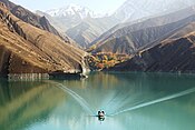
Upper Gotvand Dam, or simply the Gotvand Dam, is an embankment dam on the Karun River about 12 km (7.5 mi) northeast of Gotvand in Khuzestan Province, Iran. It currently has an installed capacity of 1,000 MW with another 1,000 MW in the works for a second phase. Studies for the Karun River began in the 1960s and specific designs on the Upper Gotvand were presented in 1967, 1975 and 1982. After the design and location were chosen, a further study was carried out in 1997, the same year preliminary construction began. The river was diverted by April 2003 and excavation began soon thereafter. After completion of the dam, impounding of its reservoir began on 30 July 2011 during a ceremony attended by Iranian President Mahmood Ahmadinejad. The first generator of phase one was commissioned on 5 May 2012, two more by 18 September 2012 and the final in November 2012. Ahmadinejad was again present for the dam's inauguration on 22 April 2013. Phase 2 is estimated to be complete in 2015 and the dam is going to become one of Iran's largest power stations and is already its tallest earth-fill dam.
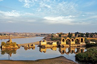
The Band-e Kaisar, Pol-e Kaisar, Bridge of Valerian or Shadirwan was an ancient arch bridge in the city of Shushtar, Khuzestan province, Iran, and the first in the country to combine it with a dam. Built by the Sassanids during the 3rd century CE, using Roman prisoners of war as the workforce, it is the easternmost example of Roman bridge design and Roman dam. Its dual-purpose design exerted a profound influence on Iranian civil engineering and was instrumental in developing Sassanid water management techniques.
Persatuan Sepakbola Padang Panjang, commonly known as PSPP, is an Indonesian football club based in Padang Panjang, West Sumatra. This club played in Liga 3 West Sumatra zone.

The Sardasht Dam is an embankment dam currently under construction on the Little Zab 13 km (8 mi) southeast of Sardasht in the Iranian province of West Azerbaijan. Reconnaissance studies for the dam were completed in 1999 by Moshanir Consulting Engineers Company. When complete, it will be a 116 m (381 ft) tall and 275 m (902 ft) long rock-fill earth core dam. It will support a hydroelectric power station with an installed capacity of 150 MW and expected annual generation of 482 GWh. The construction contract for the dam was awarded in 2009. Official construction on the dam began in 2011. The river diversion tunnels were complete in November 2012 in a ceremony attended by Iran's Ministry of Energy Majid Namjoo. The dam began to impound its reservoir on 22 June 2017.

On 25 February 2022 at 08:39 WIB, a moment magnitude (Mw ) 6.2 earthquake struck West Sumatra, Indonesia at a depth of 4.0 km (2.5 mi). Preceded by one foreshock and followed by over 200 aftershocks, the mainshock had an epicenter at the foot of Mount Talakmau in Pasaman Regency. The mainshock was the result of strike-slip faulting along a previously unidentified segment of the Great Sumatran Fault. At least 27 people died, 457 were injured, and 19,221 others were displaced. It inflicted 780 million Indonesian rupiahs (Rp) worth of damage. The heaviest damage was recorded at three villages around Mount Talakmau. Landslides and flash floods caused additional damage and casualties.