King River (Tasmania)

Last updated

King
King River 1970s.jpg
King River near Mount Huxley in the 1970s prior to damming. Frenchmans Cap is located in upper left corner of the photo.
Relief Map of Tasmania.png
Red pog.svg
Location of the King River mouth in Tasmania
Etymology King of Australia
Location
Country Australia
State Tasmania
Region West Coast
Physical characteristics
SourceThureau Hills, West Coast Range
Source confluence Eldon and South Eldon rivers
  locationnear Eldon Range
  coordinates 42°0′46″S145°41′35″E / 42.01278°S 145.69306°E / -42.01278; 145.69306
  elevation243 m (797 ft)
Mouth Lettes Bay, Macquarie Harbour
  location
near Strahan
  coordinates
42°11′35″S145°21′13″E / 42.19306°S 145.35361°E / -42.19306; 145.35361 Coordinates: 42°11′35″S145°21′13″E / 42.19306°S 145.35361°E / -42.19306; 145.35361
  elevation
0 m (0 ft)
Length52 km (32 mi)
Basin features
Tributaries 
  leftGovernor River, Nelson River (Tasmania), Princess River
  rightTofft River, Queen River, Tasmania
Reservoir Lake Burbury
[1]

The King River is a major perennial river in the West Coast region of Tasmania, Australia.

Contents

Location and features

King river at entrance to Macquarie Harbour - the West Coast Wilderness Railway line passes from the right of this picture to enter the King River Valley at the left of photo. Delta of eroded material is typical at this location. Hell's Gates is at top of picture (out of view) and Strahan is to the right off photo. Photo hazy due to bushfires of January 2003. King river at macquarie harbour.jpg
King river at entrance to Macquarie Harbour - the West Coast Wilderness Railway line passes from the right of this picture to enter the King River Valley at the left of photo. Delta of eroded material is typical at this location. Hell's Gates is at top of picture (out of view) and Strahan is to the right off photo. Photo hazy due to bushfires of January 2003.

Formed by the confluence of the Eldon and South Eldon rivers, the King River rises near Eldon Range on the slopes of the West Coast Range between Mount Huxley and Mount Jukes. The river flows generally south and then west, joined by nine tributaries including the Tofft, Governor, Nelson, Princess, and Queen rivers before emptying into Macquarie Harbour near Strahan, and merging with the Southern Ocean. The river descends 24 metres (79 ft) over its 52-kilometre (32 mi) course. [1]

The upper section of the river lies in a glaciated valley, with glacier scouring scars high up on the upper parts of the mountains of the West Coast Range. Also small glacial lakes occur on and north of Mount Sedgwick. Lake Beatrice for instance lies on the eastern slope of Mount Sedgwick. The upper portion of the King River valley was first surveyed for damming in 1917 by the Mount Lyell Mining and Railway Company.

King River Power Development Scheme

The river is impounded by the Crotty Dam to form Lake Burbury, covering 54 square kilometres (21 sq mi) over the former valley and named after the first Australian born Governor of Tasmania, Stanley Burbury. Water drawn from the lake is used to supply the conventional hydroelectric John Butters Power Station, operated by Hydro Tasmania. Below the dam wall, the river flows through a narrow channel as it flows west towards Teepookana, in the last 10 kilometres (6.2 mi) of the river, where extensive silting from the mine tailings that have been carried down from Queenstown, has created such a resource that at least one mining company has in the past proposed the mining of the deposits at the edge of the river, as well as the delta formed out into Macquarie Harbour due to the amount of economically viable materials in the silt.

The small timber mill community adjacent to the old alignment of the Lyell Highway was submerged, as was a significant portion of the old railway alignment of the North Mount Lyell Railway between Linda and Pillinger. The site of the townsite of Crotty, and the smelters of Crotty were also submerged.

Queen River

King River gorge lower west end, from Abt Railway looking east King River gorge from abt railway 02.JPG
King River gorge lower west end, from Abt Railway looking east

The King River was considered to be Australia's most polluted river. [2] Mining started in the 1880s, with the Queen River, a major tributary of the King River, being used for waste water disposal from the Mt Lyell copper mine.

Between 1922 and 1995 low grade ore was concentrated on site and the tailings (ore-washing residue) dumped in the river also. [3]

About 1.5 million tonnes of sulfidic tailings entered the river system each year up to 1995, along with huge volumes of acidic, metal-rich water flowing from the workings. This 'acid mine drainage' is derived from water leaching through the exposed and oxidised sulfide rocks. When it was in operation, the fumes from the ore smelter produced acid rain which also leached minerals from the bare Queenstown hills. [4]

In 1992 the King River was dammed above the confluence with the Queen River to generate hydroelectric power at the Crotty Dam. This changed the flow regime in the King River, and affected the way tailings were transported through the river system. The tailings in the river greatly affect the water quality. [5]

About 100 million tonnes of tailings have been deposited on the banks and bed of the King River and in a delta at the mouth of the river where it enters Macquarie Harbour. [6]

Since the closure of the mine in late 1995, and the construction of a tailings dam by the new operators, tailings no longer enter the river system. However, acid water continues to enter the river due to mine dewatering and run-off from the waste rock dumps. Without the buffering previously provided by the alkaline tailings, the acidity in the Queen and King rivers has increased, and dissolved metal concentrations have greatly increased-to levels highly toxic to aquatic life.

Abt Railway route

The north bank (except for the Teepookana to Quarter Mile Bridge section which was on the south bank) of the lower portion of the King River valley was the route for the old "Abt" rack railway to Queenstown. In 1962 the original builder and owner, the Mount Lyell Mining and Railway Company closed and removed the line. This has been since restored in early 2002 for tourism purposes. The new line follows exactly the same route and is known as the West Coast Wilderness Railway. [7]

See also

Related Research Articles

Queenstown, Tasmania Town in Tasmania, Australia

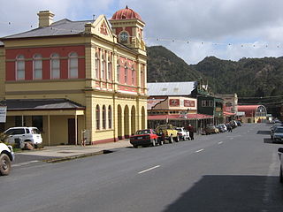
Queenstown is a town in the West Coast region of the island of Tasmania, Australia. It is in a valley on the western slopes of Mount Owen on the West Coast Range.

Macquarie Harbour Large inlet on the West Coast of Tasmania

Macquarie Harbour is a shallow fjord located in the West Coast region of Tasmania, Australia. It is approximately 315 sq.km, and has an average depth of 15m, with deeper places up to 50m. It is navigable by shallow-draft vessels. The main channel is kept clear by the presence of a rock wall on the outside of the channel's curve. This man-made wall prevents erosion and keeps the channel deep and narrow, rather than allowing the channel to become wide and shallow. A reported Aboriginal name for the harbour is Parralaongatek.

West Coast Range Mountain range in Tasmania, Australia

The West Coast Range is a mountain range located in the West Coast region of Tasmania, Australia.

Mount Lyell Mining and Railway Company was a Tasmanian mining company formed on 29 March 1893, most commonly referred to as Mount Lyell. Mount Lyell was the dominant copper mining company of the West Coast from 1893 to 1994, and was based in Queenstown, Tasmania.

Regatta Point, Tasmania Port and locality in Western Tasmania

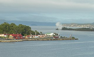
Regatta Point is the location of a port and rail terminus on Macquarie Harbour.

Gormanston, Tasmania Town in Tasmania, Australia

Gormanston is a town in Tasmania on the slopes of Mount Owen, above the town of Queenstown in Tasmania's West Coast. At the 2016 Gormanston had a population of 17.

Crotty, Tasmania former township in Tasmania

Crotty is a former gazetted townsite that was located in Western Tasmania, Australia. The township was located on the eastern lower slopes of Mount Jukes, below the West Coast Range, and on the southern bank of the King River. The locality had had a former name of King River

North Mount Lyell Railway Former railway company in Tasmania

The North Mount Lyell Railway was built to operate between the North Mount Lyell mine in West Coast Tasmania and Pillinger in the Kelly Basin of Macquarie Harbour.

Queen River, Tasmania River in western Tasmania

The Queen River, part of the King River catchment, is a minor perennial river located in the West Coast region of Tasmania, Australia.

The Mount Jukes Mine sites were a series of short-lived, small mine workings high on the upper regions of Mount Jukes in the West Coast Range on the West Coast of Tasmania.

Lake Burbury

Lake Burbury is a man-made water reservoir created by the Crotty Dam inundating the upper King River valley that lies east of the West Coast Range. Discharge from the reservoir feeds the John Butters Hydroelectric Power Station, owned and operated by Hydro Tasmania.

Mount Huxley (Tasmania)

Mount Huxley is a mountain located on the West Coast Range in the West Coast region of Tasmania, Australia. With an elevation of 926 metres (3,038 ft) above sea level, the mountain was named by Charles Gould in 1863 in honour of Professor Thomas Henry Huxley.

Mount Jukes (Tasmania)

Mount Jukes is a mountain located on the Jukes Range, a spur off the West Coast Range, in the West Coast region of Tasmania, Australia.

Pillinger is an abandoned port and townsite in Kelly Basin, on the south eastern side of Macquarie Harbour on the West Coast of Tasmania.

Crotty Dam Dam in West Coast Tasmania

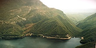
The Crotty Dam, also known during construction as the King Dam, or the King River Dam on initial approval, is a rockfill embankment dam with a controlled and uncontrolled spillway across the King River, between Mount Jukes and Mount Huxley, located in Western Tasmania, Australia.

Darwin Dam Dam in Western Tasmania

The Darwin Dam is an offstream earthfill embankment saddle dam without a spillway, located in Western Tasmania, Australia. The impounded reservoir, also formed by Crotty Dam, is called Lake Burbury.

Linda, Tasmania Town in Tasmania, Australia

Linda is the site of an old ghost town in the Linda Valley in the West Coast Range of Tasmania, Australia. It has also been known as Linda Valley.

The Mount Lyell Remediation and Research and Demonstration Program was a joint rehabilitation programme between the Supervising Scientist Australia and the Department of Environment and Land Management, Tasmania to clean up the King River, Queen River and Macquarie Harbour.

James Crotty (1845–1898) was an Irish-born mining prospector who formed a mining company, the North Mount Lyell mining company, in the western region of Tasmania, just before the turn of the twentieth century.

West Coast Wilderness Railway Rebuilt railway between Queenstown and Strahan, Western Tasmania

The West Coast Wilderness Railway is a reconstruction of the Mount Lyell Mining and Railway Company Mount Lyell railway in Western Tasmania between Queenstown and Regatta Point, Strahan. The railway is significant because of its Abt rack system to conquer the mountainous terrain through rainforest, with original locomotives still operating on the railway today. Now operating as a tourist experience with a focus on sharing the history of Tasmania's West Coast, the original railway began operations in 1897 as the only link between Queenstown and the port of Strahan.

References

  1. 1 2 "Map of King River, TAS". Bonzle Digital Atlas of Australia. Retrieved 26 June 2015.
  2. "Tasmania's poisoned rivers become PHD students' classroom". ABC News. 24 September 2016.
  3. Davies, Peter Eric; Mitchell, Nicki; Barmuta, L. A. (Leon Alexander); Tasmania. Department of Environment and Land Management; Supervising Scientist for the Alligator Rivers Region (Australia) (1996), Mount Lyell remediation : the impact of historical mining operations at Mount Lyell on the water quality and biological health of the King and Queen River catchments, western Tasmania, Supervising Scientist, ISBN   978-0-642-24317-1
  4. Tong, G. D; Williamson, B; Supervising Scientist for the Alligator Rivers Region (Australia); Tasmania. Department of Environment and Land Management; Mount Lyell Remediation Research and Demonstration Program (1998), "Mount Lyell remediation : modelling of the hydrodynamics and chemistry of Macquarie Harbour, western Tasmania", Supervising Scientist Report, Supervising Scientist (published 1988), ISBN   978-0-642-24339-3, ISSN   1325-1554
  5. Locher, Helen; Supervising Scientist for the Alligator Rivers Region (Australia); Tasmania. Department of Environment and Land Management (1997), "Mount Lyell remediation : sediment transport in the King River, Tasmania", Supervising Scientist Report, Supervising Scientist, ISBN   978-0-642-24320-1, ISSN   1325-1554
  6. Mount Lyell Remediation Research and Demonstration Program; Taylor, Jeff R; Tasmania. Department of Environment and Land Management (1996), Mount Lyell remediation : characterisation and impact assessment of mine tailings in the King River system and delta, Western Tasmania, Supervising Scientist, ISBN   978-0-642-24304-1
  7. Rae, Lou (2001). The Abt Railway and Railways of the Lyell region. Sandy Bay: Lou Rae. ISBN   0-9592098-7-5.

Sources