Hillsboro is a rural town in Loudoun County, Virginia, United States. The population was 114 at the 2020 census.
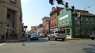
Leesburg is a town in and the county seat of Loudoun County, Virginia, United States. Its is part of both the Northern Virginia region of the state and the Washington metropolitan area, including Washington, D.C., the nation's capital.Settlement in the area began around 1740, which is named for the Lee family, early leaders of the town. Located in the far northeast of the state, in the War of 1812 it was a refuge for important federal documents evacuated from Washington, DC, and in the Civil War, it changed hands several times.

U.S. Route 211 is a spur of US 11 in the U.S. state of Virginia. Known for most of its length as Lee Highway, the U.S. Highway runs 59.09 miles (95.10 km) from Interstate 81 (I-81) and Virginia State Route 211 in New Market east to US 15 Business, US 29 Business, and US 211 Business in Warrenton. US 211 connects the Shenandoah Valley with the Piedmont town of Warrenton via Luray and Sperryville, where the highway runs concurrently with US 340 and US 522, respectively.

State Route 244 is a primary state highway in the U.S. state of Virginia. Known as Columbia Pike, the state highway runs 8.25 miles (13.28 km) from SR 236 in Annandale east to SR 27 and Interstate 395 (I-395) at The Pentagon in Arlington. SR 244 is a major southwest–northeast thoroughfare in northeastern Fairfax County and eastern Arlington County, connecting Annandale with SR 7 at Bailey's Crossroads and SR 120 in the multicultural Westmont neighborhood of Arlington.

Virginia State Route 7 (VA 7) is a major primary state highway and busy commuter route in northern Virginia, United States. It travels southeast from downtown Winchester to SR 400 in downtown Alexandria. Its route largely parallels those of the Washington & Old Dominion Trail and the Potomac River. Between its western terminus and Interstate 395 (I-395), SR 7 is part of the National Highway System. In 1968, the Virginia State Highway Commission designated the road as the "Harry Flood Byrd Highway" between Alexandria and Winchester to commemorate Harry F. Byrd Sr. (1887–1966).
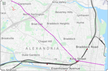
State Route 236 is a primary state highway in the U.S. state of Virginia. The state highway runs 15.63 miles (25.15 km) from U.S. Route 29 and US 50 in Fairfax east to SR 400 in Alexandria. SR 236 is a major suburban arterial highway that connects the independent cities of Fairfax and Alexandria via Annandale in Fairfax County. The state highway is known as Main Street in City of Fairfax, Little River Turnpike in Fairfax County, where the highway meets Interstate 495 (I-495), and Duke Street in Alexandria, where the road has junctions with I-395 and US 1.

The Washington and Old Dominion Railroad was an intrastate short-line railroad located in Northern Virginia, United States. The railroad was a successor to the bankrupt Washington and Old Dominion Railway and to several earlier railroads, the first of which began operating in 1859. The railroad closed in 1968.

The Washington and Old Dominion Railroad Regional Park is a linear regional park in Northern Virginia. The park's primary feature is the Washington and Old Dominion Railroad Trail, an asphalt-surfaced paved rail trail that runs through densely populated urban and suburban communities as well as through rural areas. Most of the trail travels on top of the rail bed of the former Washington and Old Dominion Railroad, which closed in 1968.

Bluemont is an unincorporated village in Loudoun County, Virginia located at the eastern base of Snickers Gap in the Blue Ridge Mountains. The village's center is located along Snickersville Turnpike, 4 miles (6.4 km) west of the incorporated town of Round Hill. The village borders Virginia's fox hunting country and is within 1 mile (1.6 km) of the Appalachian Trail and the Bears Den and Raven Rocks formations in the Blue Ridge.

The Northern Virginia trolleys were the network of electric streetcars that moved people around the Northern Virginia suburbs of Washington, D.C., from 1892 to 1941. They consisted of six lines operated by as many as three separate companies connecting Rosslyn, Great Falls, Bluemont, Mount Vernon, Fairfax, Camp Humphries, and Nauck across the Potomac River to Washington, D.C.

Old Town Alexandria is one of the original settlements of the city of Alexandria, Virginia, and is located just minutes from Washington, D.C., of which it used to make up the southern part It was the oldest district of D.C. until it was ceded back to Virginia in 1846. Old Town is situated in the eastern and southeastern area of Alexandria along the Potomac River and is laid out on a grid plan of substantially square blocks.

U.S. Route 50 is a transcontinental highway which stretches from Ocean City, Maryland to West Sacramento, California. In the U.S. state of Virginia, US 50 extends 86 miles (138 km) from the border with Washington, D.C. at a Potomac River crossing at Rosslyn in Arlington County to the West Virginia state line near Gore in Frederick County.

Maryland Route 187 is a state highway in the U.S. state of Maryland. Known as Old Georgetown Road, the highway runs 5.32 miles (8.56 km) from MD 355 and MD 410 in Bethesda north to Executive Boulevard in North Bethesda. MD 187 is a four- to six-lane highway that runs parallel to MD 355 through suburban areas of southern Montgomery County. The highway was paved through Bethesda by 1910. The remainder of MD 187 was constructed in the mid- to late 1920s. The highway was relocated at its northern end and expanded to a divided highway over most of its length in the late 1960s. MD 187's interchanges with Interstate 270 (I-270) and I-495 were built in the late 1950s and early 1960s, respectively; the former interchange was reconstructed in the early 2000s. The northern terminus was cut back from MD 355 to Executive Boulevard in 2016.
The Battle of Mile Hill was a cavalry skirmish during the American Civil War, that took place just north of Leesburg, Virginia, on September 2, 1862. It preceded the occupation of the town by the Army of Northern Virginia just prior to its crossing of the Potomac River starting the Maryland Campaign.
Northern Virginia is part of the Washington Metropolitan Area of the United States, and its surface transit system is integrated with that of the city of Washington, D.C. However, because of the Potomac River separating Northern Virginia from the city, the two systems have evolved largely independently. At present, most major bus routes, including all that cross the Potomac, are operated by the Washington Metropolitan Area Transit Authority (WMATA), while several smaller systems are city- or county-owned. Since the Washington Metro opened to Virginia, most of the bus routes have terminated on either side of the Potomac River, where passengers can transfer to the rapid transit system, or to one of the few WMATA Metrobus routes that cross the river.

Arlington Boulevard is a major arterial road in Arlington County, Fairfax County, and the independent City of Fairfax in Northern Virginia in metropolitan Washington, DC, United States. It is designated U.S. Route 50 (US 50) for its entire length and is part of the National Highway System.
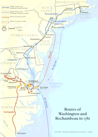
The Washington–Rochambeau Revolutionary Route is a 680-mile (1,090 km) series of roads used in 1781 by the Continental Army under the command of George Washington and the Expédition Particulière under the command of Jean-Baptiste de Rochambeau during their 14-week march from Newport, Rhode Island, to Yorktown, Virginia.
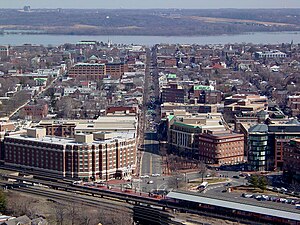
Alexandria is an independent city in the northern region of the Commonwealth of Virginia, United States. It lies on the western bank of the Potomac River approximately 7 miles (11 km) south of downtown Washington, D.C. Alexandria is the third largest "principal city" of the Washington metropolitan area which is part of the larger Washington-Baltimore combined statistical area.

The unincorporated hamlet of Malden is a bedroom community that is located on the historic 'Old National Pike' in borough of Centerville Washington County, Pennsylvania. Originally an early wagon stop in rural Pennsylvania, it became a small transportation hub during the surge of westward migration to the Northwest Territory after 1790.

The Leesburg Pike Line, designated Route 28A, is a daily bus route operated by the Washington Metropolitan Area Transit Authority between Tysons station of the Silver Line of the Washington Metro and King Street – Old Town station of the Yellow and Blue lines of the Washington Metro. The 28A trips run every 12 minutes between 7AM and 9PM and 30 minutes after 9PM. This line provides service from Tysons Corner in Fairfax County to Old Town Alexandria. Route 28A trips are roughly 90 minutes long. It is the busiest metrobus route in Virginia at around 6,400 riders per weekday in 2023.