
The Mologa is a river in Maksatikhinsky, Bezhetsky, Lesnoy, and Sandovsky Districts of Tver Oblast, Pestovsky District in Novgorod Oblast, and Ustyuzhensky and Cherepovetsky Districts in Vologda Oblast Russia. It is a left tributary of the Volga River. The lower course of the Mologa has been turned into the Rybinsk Reservoir. It is 456 kilometres (283 mi) long, and the area of its basin 29,700 square kilometres (11,500 sq mi). The principal tributaries of the Mologa are the Osen (right), the Volchina (left), the Kobozha (left), the Chagodoshcha (left) and the Sit.

Tigoda is a river in Novgorodsky and Chudovsky Districts of Novgorod Oblast and Tosnensky and Kirishsky Districts of Leningrad Oblast in Russia. It is a left tributary of the Volkhov River. The length of the river is 143 kilometres (89 mi), and the area of its drainage basin is 2,290 square kilometres (880 sq mi). The main tributaries are the Ravan (right), the Chagoda (left), and the Kusinka (left). The town of Lyuban is located on the banks of the Tigoda.

The Luga River is a river in Novgorodsky and Batetsky Districts of Novgorod Oblast and Luzhsky, Volosovsky, Slantsevsky, and Kingiseppsky Districts of Leningrad Oblast of Russia. The river flows into the Luga Bay of the Gulf of Finland. It freezes up in the early December and stays under the ice until early April. The length of the Luga is 353 kilometres (219 mi), and the area of its drainage basin is 13,200 square kilometres (5,100 sq mi). Its main tributary is the Oredezh River (right). The towns of Luga and Kingisepp, as well as the urban-type settlement of Tolmachyovo are located on the banks of the Luga. The mouth of the Luga is the site of the Ust-Luga container terminal.

The Syas River is a river in Lyubytinsky District of Novgorod Oblast and Tikhvinsky and Volkhovsky Districts of Leningrad Oblast, Russia. The Syas River flows from Valdai Hills north into Lake Ladoga. A town of Syasstroy is located at its mouth. It is 260 kilometres (160 mi) long, and the area of its basin 7,330 square kilometres (2,830 sq mi). The largest tributary of the Syas is the Tikhvinka River (right).

Shosha River is a river in Zubtsovsky, Staritsky, Kalininsky and in Konakovsky Districts of Tver Oblast and Lotoshinsky District of Moscow Oblast in Russia. It is a right tributary of the Volga River. The length of the Shosha River is 163 kilometres (101 mi). The area of its basin is 3,080 square kilometres (1,190 sq mi). The river flows into the Ivankovo Reservoir. The Shosha freezes up in November through early January and stays icebound until late March or early April.

Pasha is a river in Tikhvinsky and Volkhovsky Districts in the northeastern part of Leningrad Oblast of Russia, a left tributary of the Svir River. The Pasha is the largest of Svir's tributaries. It is 242 kilometres (150 mi) long, and the area of its basin 6,650 square kilometres (2,570 sq mi). Its largest tributary is the Kapsha River (right).

The Oyat is a river in Babayevsky District of Vologda Oblast and Podporozhsky and Lodeynopolsky Districts of Leningrad Oblast of Russia, a major left tributary of the Svir River. The length of the Oyat is 266 kilometres (165 mi), and the area of its drainage basin is 5,220 square kilometres (2,020 sq mi).

Okhta River is a river in Vsevolozhsky District of Leningrad Oblast and the eastern part of the city of Saint Petersburg, Russia. It is the largest right tributary of the Neva river. It joins the Neva 12 kilometres (7.5 mi) upstream of the Neva's mouth, within the city limits of Saint Petersburg. The length of the Okhta is 90 kilometres (56 mi), and the area of its drainage basin is 768 square kilometres (297 sq mi). Its largest tributary is the Okkervil River (left). The Rzhevsky Reservoir has been built on the Okhta. The Utkina Dacha estate is located on the banks of the Okhta close to the mouth of the Okkervil.
The Vazuza is a river in Novoduginsky and Sychyovsky districts of Smolensk Oblast and Zubtsovsky District of Tver Oblast, Russia, a right tributary of the Volga River. It is 162 kilometres (101 mi) long, and its drainage basin covers 7,120 square kilometres (2,750 sq mi). The lower part of the river has been transformed into Vazuza Reservoir. The towns of Sychyovka and Zubtsov are located on the banks the Vazuza. The main tributaries of the Vazuza are the Kasnya River, the Gzhat River, and the Osuga River (left).
The Kubena is a river in Konoshsky District of Arkhangelsk Oblast and Vozhegodsky, Syamzhensky, Kharovsky, Sokolsky, and Ust-Kubinsky Districts of Vologda Oblast in Russia. It is 368 kilometres (229 mi) long, and the area of its basin 11,000 square kilometres (4,200 sq mi). The Kubena is the principal tributary of Lake Kubenskoye and belongs to the basins of the Sukhona River and the White Sea. Its main tributaries are the Syamzhena River (left) and the Sit River (right).

The Suda is a river in Babayevsky, Kaduysky, and Cherepovetsky Districts of Vologda Oblast in Russia. It flows into the Rybinsk Reservoir of the Volga River. It is 184 kilometres (114 mi) long, with a drainage basin of 13,500 square kilometres (5,200 sq mi) and an average discharge of 134 cubic metres per second (4,700 cu ft/s). Its main tributaries are the Shogda, the Andoga, the Kolp, the Voron and the Petukh rivers.

Babayevsky District is an administrative and municipal district (raion), one of the twenty-six in Vologda Oblast, Russia. It is located in the west of the oblast and borders with Vytegorsky District in the north, Belozersky District in the east, Kaduysky District in the southeast, Ustyuzhensky District in the south, Chagodoshchensky District in the southeast, and with Boksitogorsky, Tikhvinsky, and Podporozhsky Districts of Leningrad Oblast in the west. The area of the district is 9,200 square kilometers (3,600 sq mi). Its administrative center is the town of Babayevo. Population: 21,944 (2010 Census); 24,930 ; 29,535 (1989 Census). The population of Babayevo accounts for 55.0% of the district's total population.

The Sharzhenga is a river in Nyuksensky, Babushkinsky, and Nikolsky Districts of Vologda Oblast in Russia. It is a left tributary of the Yug River. It is 183 kilometres (114 mi) long, and the area of its basin 1,500 square kilometres (580 sq mi). The main tributary is the Andanga River (right).

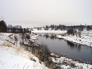
The Chagodoshcha is a river in Boksitogorsky District of Leningrad Oblast and in Chagodoshchensky, Babayevsky, and Ustyuzhensky Districts of Vologda Oblast in Russia. It is a left tributary of the Mologa River. It is 242 kilometres (150 mi) long, and the area of its basin 9,680 square kilometres (3,740 sq mi). The principal tributaries are the Lid (left), the Pes (right), and the Vnina (left).

The Pchyovzha is a river in Lyubytinsky and Chudovsky Districts of Novgorod Oblast and in Kirishsky District of Leningrad Oblast in Russia. It is a right tributary of the Volkhov River. It is 157 kilometres (98 mi) long, and the area of its basin 1,970 square kilometres (760 sq mi). The main tributary of the Pchyovzha is the Raplya (right). The urban-type settlement of Budogoshch is located on the banks of the Pchyovzha.
Verkhovye is the name of several inhabited localities in Russia.
The Loknya is a river in Loknyansky and Bezhanitsky Districts of Pskov Oblast in Russia. It is a left tributary of the Lovat River. It is 119 kilometres (74 mi) long, and the area of its basin 2,190 square kilometres (850 sq mi).

The Tikhvinka River is a river in Boksitogorsky and Tikhvinsky Districts of Leningrad Oblast, Russia, a right and the biggest tributary of the Syas. The town of Tikhvin is located on its banks. It is 144 kilometres (89 mi) long, and the area of its basin 2,140 square kilometres (830 sq mi). The main tributaries of the Tikhvinka are the Ryadan (left) and the Shomushka (right).
Kapsha is a river in Tikhvinsky and Lodeynopolsky Districts in the northeastern part of Leningrad Oblast of Russia, a right tributary of the Pasha River. The Kapsha is the largest tributary of the Pasha. It is 115 kilometres (71 mi) long, and the area of its basin 1,700 square kilometres (660 sq mi).


