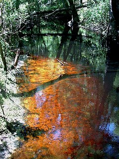
A blackwater river is a type of river with a slow-moving channel flowing through forested swamps or wetlands. As vegetation decays, tannins leach into the water, making a transparent, acidic water that is darkly stained, resembling black tea. Most major blackwater rivers are in the Amazon Basin and the Southern United States. The term is used in fluvial studies, geology, geography, ecology, and biology. Not all dark rivers are blackwater in that technical sense. Some rivers in temperate regions, which drain or flow through areas of dark black loam, are simply black due to the color of the soil; these rivers are black mud rivers. There are also black mud estuaries.

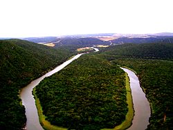
The Great Fish River is a river running 644 kilometres (400 mi) through the South African province of the Eastern Cape. The coastal area between Port Elizabeth and the Fish River mouth is known as the Sunshine Coast. The Great Fish River was originally named Rio do Infante, after João Infante, the captain of one of the caravels of Bartolomeu Dias. Infante visited the river in the late 1480s.

Gamtoos River or Gamptoos River is a river in the Eastern Cape Province, South Africa. It is formed by the confluence of the Kouga River and the Groot River and is approximately 645-kilometre (401 mi) long with a catchment area of 34,635 square kilometres (13,373 sq mi).

Port Alfred is a small town with a population of just under 26,000 in the Eastern Cape province of South Africa. It is situated on the eastern seaboard of the country at the mouth of the Kowie River, almost exactly halfway between the larger cities of Gqeberha and East London and 30 kilometres (19 mi) west of Cannon Rocks.

The Nahoon River is situated in the city of East London on the east coast of South Africa.
The Chalumna River is a river in the Eastern Cape, South Africa. It is approximately 78 km long, forming at the confluence of two small rivers, the Qugwala in the West and the Mtyolo in the East. It empties into the Indian Ocean through an estuary near Kayser's Beach.
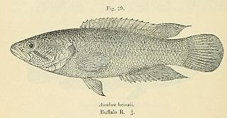
The Eastern Province rocky, also known as rocky kurper, is a species of fish in the family Anabantidae. It is endemic to South Africa.

The Cape kurper is a species of fish in the family Anabantidae, the climbing gouramis or climbing perches. It is endemic to South Africa.
The Baviaanskloof River is a river flowing through the Cape Fold Mountains of the Western Cape and eventually Eastern Cape provinces of South Africa. The river's origin is in the eastern extremity of the Little Karoo, and follows a valley between these mountains eastwards. It ends at a confluence with the Kouga River, some 80 km from its source.

The Buffalo River is situated in the city of East London on the East Coast of South Africa. It is to the west of the Nahoon River. It is the only navigable river in South Africa. The town of East London was thus established around it.
The Bloukrans River (Grahamstown) is a tributary of the Kowie River, and is situated near Grahamstown in the Eastern Cape province of South Africa.
The Tarka River is a river in the Eastern Cape, South Africa. Along with the Baviaans River, Grootbrak River and Kat River it is a major eastern tributary of the Great Fish River. The Lake Arthur Dam and the Kommandodrif Dam are located in this river. The latter is included in the Commando Drift Nature Reserve.

The Keiskamma River is a river in the Eastern Cape Province in South Africa. The river flows into the Indian Ocean in the Keiskamma Estuary, located by Hamburg Nature Reserve, near Hamburg, midway between East London and Port Alfred. The Keiskamma flows first in a southwestern and then in a southeastern direction after meeting its main tributary, the Tyhume River.

Krom River or Kromme River is a river in the Eastern Cape Province in South Africa. The river flows into the Indian Ocean through an estuary on the north side of St Francis Bay, west of Port Elizabeth. The Krom river flows in an ESE direction and is approximately 109 km long with a catchment area of 1,085 km2.
Mbhashe River is one of the major rivers in the Eastern Cape Province, South Africa. It flows in a southeastern direction and has a catchment area of 6,030 km2. The river drains into the Indian Ocean through an estuary located near the lighthouse at Bashee, south of Mhlanganisweni.
The Tsitsikamma River is a small river at the western end of the Eastern Cape coast, South Africa. It is part of the Fish to Tsitsikama Water Management Area.

The Cape Government Railways 0-4-0ST Aid of 1878 was a South African steam locomotive from the pre-Union era in the Cape of Good Hope.
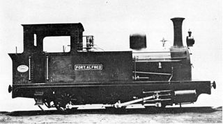
The Kowie Railway 0-6-0T of 1882 was a South African steam locomotive from the pre-Union era in the Cape of Good Hope.

The Kowie Railway 4-4-0T of 1882 was a South African steam locomotive from the pre-Union era in the Cape of Good Hope.
