
The Marshall Islands, officially the Republic of the Marshall Islands, is an independent island country near the Equator in the Pacific Ocean, slightly west of the International Date Line. Geographically, the country is part of the larger island group of Micronesia. The country's population of 58,413 people is spread out over five islands and 29 coral atolls, comprising 1,156 individual islands and islets. The capital and largest city is Majuro. It has the largest portion of its territory composed of water of any sovereign state, at 97.87%. The islands share maritime boundaries with Wake Island to the north, Kiribati to the southeast, Nauru to the south, and Federated States of Micronesia to the west. About 52.3% of Marshall Islanders live on Majuro. In 2016, 73.3% of the population were defined as being "urban". The UN also indicates a population density of 760 inhabitants per square mile (295/km2), and its projected 2020 population is 59,190.

This article is about communications systems in the Marshall Islands.

Majuro is the capital and largest city of the Marshall Islands. It is also a large coral atoll of 64 islands in the Pacific Ocean. It forms a legislative district of the Ratak (Sunrise) Chain of the Marshall Islands. The atoll has a land area of 9.7 square kilometres (3.7 sq mi) and encloses a lagoon of 295 square kilometres (114 sq mi). As with other atolls in the Marshall Islands, Majuro consists of narrow land masses. It has a tropical trade wind climate, with an average temperature of 27 °C (81 °F).
Kwajalein Atoll is part of the Republic of the Marshall Islands (RMI). The southernmost and largest island in the atoll is named Kwajalein Island, which its majority English-speaking residents often use the shortened name, Kwaj. The total land area of the atoll amounts to just over 6 square miles (16 km2). It lies in the Ralik Chain, 2,100 nautical miles southwest of Honolulu, Hawaii.

The Ralik Chain is a chain of islands within the island nation of the Marshall Islands. Ralik means "sunset". It is west of the Ratak Chain. In 1999 the total population of the Ralik islands was 19,915. Christopher Loeak, who became President of the Marshall Islands in 2012, was formerly Minister for the Ralik Chain.

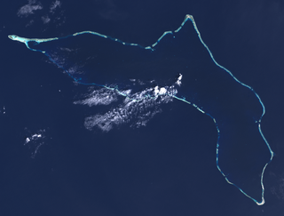
Mili Atoll is a coral atoll of 92 islands in the Pacific Ocean, and forms a legislative district of the Ratak Chain of the Marshall Islands. It is located approximately 78 kilometres (48 mi) southeast of Arno. Its total land area is 14.9 square kilometres (5.8 sq mi) making it the second largest of the Marshall Islands after Kwajalein. It encloses a much smaller lagoon than Kwajalein, with an area of 760 square kilometres (290 sq mi). The atoll is separated by a water channel called the Klee Passage from the Knox Atoll which is considerably smaller. The population of Mili Atoll was 738 as of 2011. The main village is also called Mili. Other villages include Nallu, Enejet, Lukonor, Tokewa, and Wau, Mili. Nallu, Enejet and Lukonwor are only accessible from Mili by land during lowtide. Only Mili, Mili and Enejet, Mili have runways for small aircraft. Mili Airport and Enejit Airport are served by Air Marshall Islands when its aircraft are operational.

Wotho Atoll is a coral atoll of 13 islands in the Pacific Ocean, and forms a legislative district of the Ralik Chain of the Marshall Islands. Its total land area is only 4.33 square kilometres (1.67 sq mi), but it encloses a lagoon of 94.92 square kilometres (36.65 sq mi). The name "Wotho" means either "entrance through the reef", or "island far away" according to different sources.

The Battle of Kwajalein was fought as part of the Pacific campaign of World War II. It took place from 31 January – 3 February 1944, on Kwajalein Atoll in the Marshall Islands. Employing the hard-learned lessons of the Battle of Tarawa, the United States launched a successful twin assault on the main islands of Kwajalein in the south and Roi-Namur in the north. The Japanese defenders put up stiff resistance, although outnumbered and under-prepared. The determined defense of Roi-Namur left only 51 survivors of an original garrison of 3,500.
Lae Atoll is a coral atoll of 20 islands in the Pacific Ocean, and forms a legislative district of the Ralik Chain of the Marshall Islands. Its total land area is only 1.5 square kilometres (0.58 sq mi), but it encloses a lagoon with an area of 17.7 square kilometres (6.8 sq mi). It is located approximately 47 kilometres (29 mi) east of Ujae Atoll. The population of Lae Atoll was 347 in 2011.

Ujae Atoll is a coral atoll of 15 islands in the Pacific Ocean, and forms a legislative district of the Ralik Chain of the Marshall Islands. Its total land area is only 1.86 square kilometres (0.72 sq mi), but it encloses a lagoon of 185.94 square kilometres (71.79 sq mi). It is located about 122 kilometres (76 mi) west of Kwajalein Atoll.

Utirik Atoll or Utrik Atoll is a coral atoll of 10 islands in the Pacific Ocean, and forms a legislative district of the Ratak Chain of the Marshall Islands. Its total land area is only 2.4 square kilometres (0.94 sq mi), but it encloses a lagoon with an area of 57.7 square kilometres (22.29 sq mi). It is located approximately 47 kilometres (29 mi) east of Ujae Atoll. The population of Utirik Atoll is 300-400 as of 2020. it is one of the northernmost Marshall Islands with permanent habitation.

Namu Atoll is a coral atoll of 54 islands in the Pacific Ocean, and forms a legislative district of the Ralik Chain of the Marshall Islands. Its total land area is only 6.27 square kilometres (2.42 sq mi), but that encloses a lagoon of 397 square kilometres (153 sq mi). It is located approximately 62 kilometres (39 mi) south-southwest of Kwajalein Atoll.

Kunio David Lemari was a Marshallese politician. He was the Minister of Justice from 1985 to 1987. He served as the acting President of the Marshall Islands from 20 December 1996 to 14 January 1997. He assumed office upon the death of the previous President, Amata Kabua, having previously served as the country's Minister of Transportation and Communications.
Ujae Airport is a public use airstrip at Ujae on Ujae Atoll, Marshall Islands.

The following is an alphabetical list of topics related to the Republic of the Marshall Islands.

A general election was held in the Marshall Islands on 21 November 2011. The general election is held every four years.

Severe Tropical Storm Zelda was the last tropical cyclone of the 1991 Pacific typhoon season and caused damage in the Marshall Islands on November 28. The area of low pressure that eventually became Zelda formed near the International Date Line, and strengthened into a tropical depression on November 27. The Joint Typhoon Warning Center (JTWC) reported that the depression had reached tropical storm intensity near the Marshall Islands on November 28, thus naming it Zelda. On November 29, the storm quickly strengthened to 65 knots according to the JTWC, equivalent to a Category 1 typhoon on the Saffir–Simpson hurricane wind scale. It reached a peak of 80 kn according to the JTWC, and 60 kn according to the Japanese Meteorological Agency (JMA), with a barometric pressure of 975 hectopascals (28.8 inHg). Zelda weakened into a tropical storm on December 2, and then a tropical depression two days later. The JTWC discontinued warnings late on December 4, while the JMA declared the storm to be extratropical the next day and continued to track until it crossed the International Date Line again on December 7.

Tropical Storm Bavi, known in the Philippines as Tropical Storm Betty, influenced the trade winds over the Pacific Ocean and was partially responsible for one of the strongest trade wind reversals ever observed. The system was first noted as a tropical disturbance during March 8, 2015, while it was located to the southeast of Kwajalein Atoll in the Marshall Islands. Over the next couple of days the system moved north-westwards through the Marshall Islands, before it was classified as a tropical depression during March 10. The system subsequently moved north-westwards and continued to develop further, before it was classified as the third tropical storm of the 2015 Pacific typhoon season and named Bavi by the Japan Meteorological Agency (JMA) during March 11. After continuing its north-westwards movement, the system peaked as a tropical storm during March 14, before it started to weaken as it approached the Mariana Islands. The system subsequently passed over Guam during the next day, before continuing its west-northwestwards movement as it gradually weakened over the next few days. The system entered the Philippine area of responsibility, where it was named Betty by PAGASA during March 17 as the system weakened into a tropical depression. The system was subsequently last noted during March 21, as it dissipated over the Philippines.

Republic of Marshall Islands Public School System (PSS) is the public school system of the Marshall Islands, headquartered in Majuro. It was established in November 2013 by Public Law 2013-23.

Marshallese cuisine comprises the fare, foods, beverages and foodways of the Marshall Islands, including its food-related customs and traditions. Common indigenous and traditional foods include breadfruit, coconut, bananas, papaya, seafood, pandanus and bwiro. Additional imported foods, such as rice and flour, are also a part of people's diets and contribute to the cuisine as well. The practice of food preservation is a part of the history of the islands, and continues to occur today.
