
The Marshall Islands, officially the Republic of the Marshall Islands, is an island country near Guam in the Pacific Ocean, slightly west of the International Date Line. Geographically, the country is part of the larger island group of Micronesia.

The Marshall Islands consist of two archipelagic island chains of 30 atolls and 1,152 islands, which form two parallel groups—the "Ratak" (sunrise) chain and the "Ralik" (sunset) chain. The Marshalls are located in the North Pacific Ocean and share maritime boundaries with Micronesia and Kiribati. Two-thirds of the nation's population lives in the capital of Majuro and the settlement of Ebeye. The outer islands are sparsely populated due to lack of employment opportunities and economic development.
Micronesians settled the Marshall Islands in the 2nd millennium BC, but there are no historical or oral records of that period. Over time, the Marshallese people learned to navigate over long ocean distances by canoe using traditional stick charts.

Majuro is the capital and largest city of the Marshall Islands. It is also a large coral atoll of 64 islands in the Pacific Ocean. It forms a legislative district of the Ratak (Sunrise) Chain of the Marshall Islands. The atoll has a land area of 9.7 square kilometers (3.7 sq mi) and encloses a lagoon of 295 square kilometers (114 sq mi). As with other atolls in the Marshall Islands, Majuro consists of narrow land masses. It has a tropical trade wind climate, with an average temperature of 27 °C (81 °F).

Enewetak Atoll is a large coral atoll of 40 islands in the Pacific Ocean and with its 296 people forms a legislative district of the Ralik Chain of the Marshall Islands. With a land area total less than 5.85 square kilometers (2.26 sq mi), it is no higher than 5 meters (16.4 ft) and surrounds a deep central lagoon, 80 kilometers (50 mi) in circumference. It is the second-westernmost atoll of the Ralik Chain and is 305 kilometers (190 mi) west from Bikini Atoll.

The Ratak Chain is a chain of islands within the island nation of the Marshall Islands. Ratak means "sunrise". It lies to the east of the country's other island chain, the Ralik Chain. In 1999 the total population of the Ratak islands was 30,925.
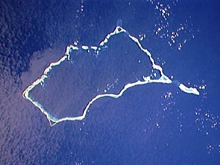
Mili Atoll is a coral atoll of 92 islands in the Pacific Ocean, and forms a legislative district of the Ratak Chain of the Marshall Islands. It is located approximately 78 kilometers (48 mi) southeast of Arno. Its total land area is 14.9 square kilometers (5.8 sq mi) making it the second largest of the Marshall Islands after Kwajalein. It encloses a much smaller lagoon than Kwajalein, with an area of 760 square kilometers (290 sq mi). The atoll is separated by a water channel called the Klee Passage from the Knox Atoll which is considerably smaller. The population of Mili Atoll was 738 as of 2011. The main village is also called Mili. Other villages include Nallu, Enejet, Lukonor, Tokewa, and Wau, Mili. Nallu, Enejet and Lukonwor are only accessible from Mili by land during lowtide. Only Mili and Enejet have runways for small aircraft. Mili Airport and Enejit Airport are served by Air Marshall Islands when its aircraft are operational.
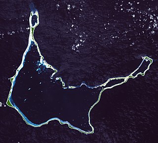
Arno Atoll is a coral atoll of 133 islands in the Pacific Ocean, and forms a legislative district of the Ratak Chain of the Marshall Islands. Its total land area is only 5 square miles (13 km2). Unlike most other atolls, Arno encloses three different lagoons, a large central one, and two smaller ones in the north and east. Its main lagoon encloses an area of 130.77 square miles (338.7 km2). At a distance of only 20 kilometers (12 mi), it is the closest atoll to the Marshall Islands capital, Majuro Atoll, and can be seen looking east from Majuro on a clear day at low tide. The population of Arno Atoll was 1,794 at the 2011 census. The most populous islets are Ajeltokrok, Kobjeltak, Rearlaplap, Langor and Tutu. The largest village is Ine, Arno.

Amata Kabua was the first President of the Marshall Islands from 1979 until his death in 1996.

Air Marshall Islands is an airline based in Majuro, Marshall Islands. It is the flag carrier of the Marshall Islands, operating inter-island services in the Central Pacific. Its main base is Marshall Islands International Airport, Majuro.
Iroijlaplap are the traditional paramount chiefs in the Marshall Islands. Ordinary chiefs bear the title of Iroij ; -ļapļap is a superlative suffix.

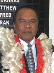
Iroij Litokwa Tomeing was the President of the Marshall Islands from January 2008 until October 2009.

The following is an alphabetical list of topics related to the Marshall Islands.
Japanese settlement in the Marshall Islands was spurred on by Japanese trade in the Pacific region. The first Japanese explorers arrived in the Marshall Islands in the late 19th century, although permanent settlements were not established until the 1920s. As compared to other Micronesian islands in the South Seas Mandate, there were fewer Japanese who settled in the islands. After the Japanese surrender in 1945, the Japanese populace were repatriated to Japan, although people of mixed Japanese–Marshallese heritage remained behind. They form a sizeable minority in the Marshall Islands' populace, and are well represented in the corporate, public and political sectors in the country.
Iroijlaplap Jurelang Zedkaia was a Marshallese politician and Iroijlaplap. He served as the President of the Marshall Islands from 2009 to 2012. He was elected as the country's 5th head of state on October 26, 2009, following the ouster of his predecessor, Litokwa Tomeing, in the country's first successful vote of no confidence.
The Baháʼí Faith in the Marshall Islands begins after 1916 with a mention by ʻAbdu'l-Bahá, then head of the religion, that Baháʼís should take the religion there. The first Baháʼí to pioneer there arrived in August 1954 however she could only stay until March 1955. Nevertheless, with successive pioneers and converts the first Baháʼí Local Spiritual Assembly in 1967 in Majuro. The community continued to grow and in 1977 elected its first National Spiritual Assembly. Before 1992 the Baháʼís began to operate state schools under contract with the government. Middle estimates of the Baháʼí population are just over 1,000, or 1.50% in 2000.

Majuro Airfield or Naval Air Facility Majuro (NAF Majuro) is a former World War II airfield on the island of Delap in the Marshall Islands. The facility was supported by the large base, Naval Base Majuro

Republic of Marshall Islands Public School System (PSS) is the public school system of the Marshall Islands, headquartered in Majuro. It was established in November 2013 by Public Law 2013-23.
Jaluit High School (JHS) is a secondary school in Jabor, Jaluit Atoll, Marshall Islands. It is a part of the Marshall Islands Public School System.

Naval Base Marshall Islands were United States Navy advance bases built on the Marshall Islands during World War II to support the Pacific War efforts. The bases were built by US Navy after the Marshall Islands campaign that captured the islands from the Empire of Japan. By February 1944 the United States Armed Forces had captured the islands. Most of the airfields and other facilities Japan had built were destroyed in allied bombing raids and naval bombardment. US Navy Seabee Construction Battalions arrived as soon as the area was secured and remove the debris. The Seabees quickly repaired, built and improved the airfield/runways and seaport. Seabees often worked around the clock to get airfields operational so that fighter aircraft and bombers could start operating. The bases were used for staging upcoming campaigns and for repair.
