Boyacá is one of the thirty-two departments of Colombia, and the remnant of Boyacá State, one of the original nine states of the "United States of Colombia".

Colombia is a unitary republic made up of thirty-two departments and a Capital District. Each department has a governor (gobernador) and an Assembly, elected by popular vote for a four-year period. The governor cannot be re-elected in consecutive periods. Departments are country subdivisions and are granted a certain degree of autonomy.

Barrancabermeja is a municipality and city in Colombia, located on the shore of the Magdalena River, in the western part of the department of Santander. It is home to the largest oil refinery in the country, under direct management of ECOPETROL. Barrancabermeja is known as the Oil Capital of Colombia.

Puerto Boyacá is a Colombian river-port town and municipality by the Magdalena River in the Boyacá Department, where is also considered a Special Trade Zone due to its port status. Its main industries are oil exploration and processing. In the 1980s and early 1990s, Puerto Boyacá was affected intensively by the Colombian Armed Conflict.

Caucasia is a municipality located in the subregion of Bajo Cauca Antioquia department, in Colombia. Bounded on the south by the department of Córdoba, in the east by the municipalities of Antioquia in Nechí and El Bagre, on the north by the municipality of Zaragoza, and west to the town of Cáceres, and is located 270 km from Medellín.

Itagüí is a city and municipality of Colombia, located in the south of the Aburrá Valley in the Antioquia Department. It is part of The Metropolitan Area of the Aburrá Valley.

Jericó is a town, municipality and Catholic bishopric in the Colombian department of Antioquia. It is part of the subregion of Southwestern Antioquia. The distance reference from Medellín city, the capital of the department, is 104 km.

Sabaneta is a municipality of Colombia, located in the Aburrá Valley of the Antioquia department. It is bordered on the north by the municipalities of La Estrella, Itagüí and Envigado, on the east by the municipality of Envigado, on the south by the municipality of Caldas, and on the west by the municipality of La Estrella.
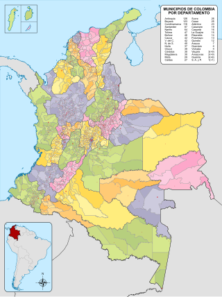
The Municipalities of Colombia are decentralized subdivisions of the Republic of Colombia. Municipalities make up most of the departments of Colombia with 1,122 municipalities (municipios). Each one of them is led by a mayor (alcalde) elected by popular vote and represents the maximum executive government official at a municipality level under the mandate of the governor of their department which is a representative of all municipalities in the department; municipalities are grouped to form departments.
Water supply and sanitation in Colombia have been improved in many ways over the past decades. Between 1990 and 2010, access to improved sanitation increased from 67% to 82%, but access to improved water sources increased only slightly from 89% to 94%. In particular, coverage in rural areas lags behind. Furthermore, despite improvements, the quality of water and sanitation services remains inadequate. For example, only 73% of those receiving public services receive water of potable quality and in 2006 only 25% of the wastewater generated in the country underwent any kind of treatment.

Corregimiento is a term used in Colombia to define a subdivision of Colombian municipalities. According to the Colombian Constitution of 1991 and Decree 2274 of October 4, 1991, a corregimiento is an internal part of a Department or province, which includes a population core. It is usually less populated than a municipality..

Barichara is a town and municipality in the Santander Department in northeastern Colombia.

Guateque is a town and municipality in the Colombian Department of Boyacá, part of the subregion of the Eastern Boyacá Province. Guateque's urban center is located at an altitude of 1,815 metres (5,955 ft) on the Altiplano Cundiboyacense at distances of 125 kilometres (78 mi) from the department capital Tunja and 112 kilometres (70 mi) from Bogotá, capital of Colombia. It borders the municipalities of La Capilla, Tenza, Sutatenza, Somondoco of Boyacá and Tibiritá and Manta of Cundinamarca.

Turmequé is a town and municipality in the Colombian Department of Boyacá, part of the subregion of the Márquez Province. Turmequé is located at 105 kilometres (65 mi) northeast from the capital Bogotá. The municipality borders Ventaquemada in the west, in the east Úmbita, in the north Nuevo Colón and in the south the municipality Villapinzón of the department of Cundinamarca.

La Calera is a municipality and town of Colombia in the Guavio Province, part of the department of Cundinamarca. La Calera is a common weekend destination, mainly for the many restaurants, as it is approximately 18 kilometres (11 mi) over land from Bogotá, the capital city of Colombia. La Calera is located in the Eastern Ranges of the Colombian Andes, east of the capital and overlooking part of it. La Calera borders Guasca, Sopó and Chía in the north, Guasca and Junín in the east, Bogotá in the west and Choachí and Fómeque in the south.

The Metropolitan Area of the Aburrá Valley is the second most important and populated metropolitan area in Colombia. The region is made up of ten municipalities, Medellín (Colombia) being the most important and largest the capital city of the Antioquia Department.

Metropolitan Area of Bogotá is the metropolitan area of the Colombian capital city of Bogotá, usually used for statistical analysis or technical use. It is not a formal administrative division and its limits are therefore not defined.

Planura is a municipality in the west of the Brazilian state of Minas Gerais. As of 2020 the population was 12,292 in a total area of 318 km². It became a municipality in 1962.
Colombia is a unitary republic conformed by thirty-two departments and a Capital District. Each department has a Governor (gobernador) and a Department Assembly, elected by popular vote for a four-year period. The governor cannot be re-elected consecutively.