Yotoco

Last updated
Yotoco
Municipality and town
Flag of Yotoco (Valle del Cauca).svg
Colombia - Valle del Cauca - Yotoco.svg
Location of the municipality and town of Yotoco in the Valle del Cauca Department of Colombia.
CountryFlag of Colombia.svg  Colombia
Department Valle del Cauca Department
Area
[1]
  Total321 km2 (124 sq mi)
Population
 (2015)
  Total16,263
  Density51/km2 (130/sq mi)
Time zone UTC-5 (Colombia Standard Time)

Yotoco is a town and municipality located in the Department of Valle del Cauca, Colombia.

Contents

History

Yotoco is a municipality of “Valle del Cauca” (Colombia) and is located in the center subregión. It is known as the king of the winds and was founded in 1622 on the banks of the river that bears his name. Is far from Cali to about 75 km, stand as architectural and tourist references The Making Hato Viejo declared a national monument since 1996 and the Sonso Laguna. According to historians this region was inhabited by freeloaders Indians during the arrival of the Spanish conquistadors and was founded by the Spanish Captain Diego Rengifo Salazar in the year 1622, on the banks of the river that bears his name. According to legend, at that site commanded the chief Yotoco and the name Yotat means "blowgun" because the population was near the land of blowgun. On December 5, 1777 the viceparrish was erected; in 1858 it appeared as a village and in 1864 was elevated to the category of district with the name "Sucre", which was preserved until 1868. Through Decree 455 of April 24 1908 it was annexed to the municipality of Buga, then in 1912, according to Law 23 passed to the municipality of Cali. That same year it returned to belong to Buga until, finally, it was given the autonomy and became the Municipality of Yotoco.

Geography

Yotoco territory is divided into two different areas: a flat, belonging to the Cauca River Valley and another mountain, on the west, which is part of the eastern slopes of the “Cordillera Occidental”. Among the highlights orographic Altos Heart, The Garden, Guacas, La Cecilia, La Florida, Paloalto, Sugar Loaf and pulpit. Their lands are distributed in heat, hot, medium and cold floors, watered by the Cauca River and Mediacanoa rivers, stones, Volcano and Yotoco, as well as various smaller streams.

LIMITS AND SOME DISTANCES

It borders on the north with the municipality of Riofrío (29), on the east with San Pedro (31), Buga (20) and Guacarí (19), to the south with the municipality of Vijes (37), to the west with Calima-Darién (10) and Restrepo (28). It is about 75 km. to Cali (9), and about 115 km. to Buenaventura (6), it is also about 12 km. to Buga.

Economy

The main economic activities in our municipality is agriculture and other activities like hog farming, poultry, cattle rising, and the exploitation of rock and sand, coffee production, pineapple, avocado, plantain, tomato, beans and sugar cane. Due to its location on the main artery to Calima Lake and Buenaventura's port there are many hotels and restaurants located along the route, which generates great employment.

Culture

Yotoco is a municipality located in the center of Valle del Cauca of whose traditional roots are of peasant culture and various celebrations of a religious type. It is normal to find festivals and celebrations in the rural area at different times of the year. This municipality is privileged by having one of the three schools of music in the country. The name of this school is "Rey de los vientos"(King of the winds). This school is directed by Juan Pablo Parra Noreña, sponsored by The Municipal administration. Also there is a Cultural House "Herminio Salguero" which publishes the book of Cuenta cuentos que yo me invento written by the students and teachers of the educational institutions of the Municipality: Alfonso Zawadzky, Gabriela Mistral, San Juan Bosco. With the support of the Ministry of Education the book Cruce de Miradas was just published which contains pictures of memorable people and places, poems and narrations of some of its inhabitants. The Municipality counts with the "Alejandro Arce Library" both inaugurated by the Culture Ministers of the years 2008 and 2015. It is currently in the municipality as a historic cultural flagship as part of Hato Viejo Farm which is private. The farm has colonial architecture and its monumental ceiba which is about 600 years old. They are part of the beauty of rural and urban Yotoco. Chiquique wetland is also part of the fishing tradition in the municipality also contributing the traditional Bocachico and corroncho and mojarra fish that fed our "yotocences" traditional families.

Tourism

The Municipality of Yotoco is a territory in tourist development, where thanks to the support of community organizations and institutions that base this activity with sustainable processes minimizing the negative impact that this can generate.

EcoTourism

La hacienda Hato Viejo located on the road Vijes, via Panorama, it was declared a National Monument of Colombia in 1996. Whose house dates back like the chapel 350 years ago. In the eighteenth century the estate played a very important socio-economic and cultural role in the colonial economic circuit... It took care of supplying food and various products derived from sugarcane for mines. It was also an instrument for colonization and population of the region that is now called "Valle del Cauca.

LAGUNA DE EL SONSO O CHIRCAL

It is a nature reserve since 1987 by the Agreement CVC No 17, October 1978 and regulated the use of land, water and airspace by the Agreement CVC No 16, May 1979. The lake has an area of 2045 hectares located between Guacarí, Buga and Yotoco municipalities, It also is the 14th largest wetland in the upper part of the Cauca system, and it is one of the most important sites at a regional level for bird watching, environmental education, sightseeing and research . Some of the species you will find there are swamp vultures, osprey and cattle heron. It is a habitat for mammals such as the common possum, common vampire and in recent years the capybara. The most common fish are the bocachico, chamburos, Caracolíes, swifts and chambimbes. The most common shrub species are: planta de garza, gamíneas and rushes. Others like the “archucha” and stiff brooms are used by animal species as shelter, nesting and feeding. The reserve is a natural regulation system of the Cauca River and is used as a means of subsistence through artisanal fisheries.

Recreational Tourism

Here are many sites for artisanal fisheries such as: Escondite and Picapiedra Lake on the route to Buga; Colombia Lake located on the Panorama route near to the toll on the road to Mediacanoa; Chiquique Wetlands and other sites with panoramic sightseeing such as Dopo's Stone located in Dopo Town and also the Natural Reserved Park on the road to Buenaventura.

CULTURAL TOURISM SITES

Hacienda Hato Viejo –between Yotoco and Vijes-on the Panorama Road. Boyaca Central Park -Valle del Dorado

Gastronomic tourism

-From Taipa to Rancho Rojo there are a range of restaurants offering typical dishes from each region. -At the Puente Tierra truck stop on the road to Buenaventura kilometer 20, we can find specialties like their sausages and fried foods that are known nationally.

Related Research Articles

<span class="mw-page-title-main">Cali</span> District and city in Valle del Cauca, Colombia

Santiago de Cali, or Cali, is the capital of the Valle del Cauca department, and the most populous city in southwest Colombia, with 2,227,642 residents according to the 2018 census. The city spans 560.3 km2 (216.3 sq mi) with 120.9 km2 (46.7 sq mi) of urban area, making Cali the second-largest city in the country by area and the third most populous after Bogota and Medellin. As the only major Colombian city with access to the Pacific Coast, Cali is the main urban and economic center in the south of the country, and has one of Colombia's fastest-growing economies. The city was founded on 25 July 1536 by the Spanish explorer Sebastian Belalcazar.

<span class="mw-page-title-main">Valle del Cauca Department</span> Department of western Colombia

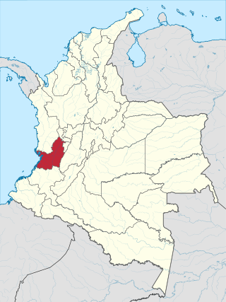
Valle del Cauca, or Cauca Valley, is a department in western Colombia abutting the Pacific Ocean. Its capital is Santiago de Cali. Other cities such as Buenaventura, Buga, Cartago, Palmira and Tuluá have great economical, political, social and cultural influence on the department's life. Valle del Cauca has the largest number of independent towns with over 100,000 inhabitants in the country, counting six within its borders. Buenaventura has the largest and busiest seaport in Colombia, moving about 8,500,000 tons of merchandise annually.

<span class="mw-page-title-main">Municipalities of Colombia</span> Decentralized subdivisions of the Republic of Colombia

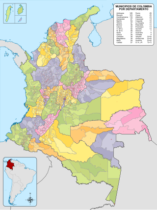
The Municipalities of Colombia are decentralized subdivisions of the Republic of Colombia. Municipalities make up most of the departments of Colombia with 1,122 municipalities (municipios). Each one of them is led by a mayor (alcalde) elected by popular vote and represents the maximum executive government official at a municipality level under the mandate of the governor of their department which is a representative of all municipalities in the department; municipalities are grouped to form departments.

<span class="mw-page-title-main">Buga, Valle del Cauca</span> Municipality and city in Valle del Cauca Department, Colombia

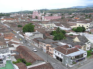
Buga, formally Guadalajara de Buga, is a city and municipality in the Valle del Cauca Department of Colombia. It is famous for its Basilica del Señor de los Milagros, which houses an image of Christ called el Señor de los Milagros.

<span class="mw-page-title-main">Cordillera Occidental (Colombia)</span> Mountain range in Colombia

The Cordillera Occidental is the lowest in elevation of the three branches of the Colombian Andes. The average altitude is 2,000 m (6,600 ft) and the highest peak is Cerro Tatamá at 4,100 m (13,500 ft). The range extends from south to north dividing from the Colombian Massif in Nariño Department, passes north through Cauca, Valle del Cauca, Risaralda, Chocó, and Caldas Departments to the Paramillo Massif in Antioquia and Córdoba Departments. From this massif the range divides further to form the Serranías de Ayapel, San Jerónimo and Abibe. Only to recede into the Caribbean plain and the Sinú River valley.

<span class="mw-page-title-main">Calima Lake</span> Reservoir in Darién, Valle del Cauca

Calima Lake is the largest artificial lake in Colombia and in the American continent with an area of 70 km2. It is located in the municipality of Darién in the Valle del Cauca Department.

<span class="mw-page-title-main">Buenaventura, Valle del Cauca</span> Municipality and city in Valle del Cauca Department, Colombia

Buenaventura is a coastal seaport city located in the Pacific Region of the department of Valle del Cauca, Colombia. Buenaventura is the main port of Colombia in the Pacific Ocean.

<span class="mw-page-title-main">La Cumbre, Valle del Cauca</span> Municipality and Town in Valle del Cauca, Colombia

La Cumbre is a town and municipality in Colombia, northwest of Cali, in the Valle del Cauca Department. It is located in the West Andes above the city of Yumbo.

<span class="mw-page-title-main">El Cerrito, Valle del Cauca</span> Municipality and town in Valle del Cauca Department, Colombia

El Cerrito is a town and municipality located in the Department of Valle del Cauca, Colombia. This is one of the 42 municipalities of the department.

<span class="mw-page-title-main">Jamundí</span> Municipality and city in Valle del Cauca Department, Colombia

Jamundí is a city and municipality in the Department of Valle del Cauca, Colombia.

<span class="mw-page-title-main">Multicoloured tanager</span> Species of bird

The multicoloured tanager is a species of bird in the family Thraupidae. It is endemic to the mountains of Colombia, and as of 2010 has been categorized as vulnerable (VU) by the IUCN.

<span class="mw-page-title-main">Farallones de Cali</span> Mountains in Colombia

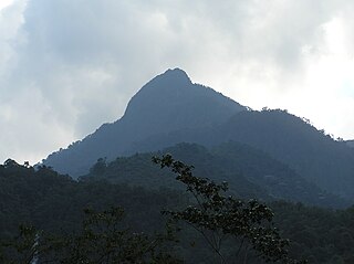
Farallones de Cali is a cluster of mountains in the West Andes of Colombia. It is located west of the city of Cali and gives rise to many of the rivers that provide water and electricity to Cali. The PNN Farallones de Cali encompasses 150,000 ha (580 sq mi) in the mountains as well as much of the Pacific slope and is an area of very high biodiversity. The average temperature ranges from 25 °C (77 °F) in the tropical foothills to 5 °C (41 °F) in the páramo. In this territory are located the district of Pichinde, Andes and Leonera, and two villages Penas Blancas and Lomas de la Cajita.

<span class="mw-page-title-main">Laguna de Sonso Nature Reserve</span>

The Laguna de Sonso Nature Reserve is located in the Valle del Cauca Department of Colombia. It contains the last extensive remnant of original natural wetland remaining in the Cauca River Valley in western Colombia, and was declared a nature reserve in October 1978. It comprises a series of marshes and lagoons on the east bank of the Cauca River, between the municipalities of Buga, Yotoco and Guacari. It has an area of 2,045 ha (7.90 sq mi), lying at an altitude of 935 m (3,068 ft). The wetlands are affected by the introduced water hyacinth. The reserve has been designated as a protected Ramsar site since 2017.

<span class="mw-page-title-main">Cauca State</span>

Cauca State was one of the states of Colombia.

<span class="mw-page-title-main">Calima culture</span> Archaeological culture of western Colombia

Calima culture is a series of pre-Columbian cultures from the Valle del Cauca in Colombia.

<span class="mw-page-title-main">Cauca culture</span>

Cauca culture is a pre-Columbian culture from the Valle del Cauca in Colombia, named for the Cauca River. Middle Cauca culture dates from the 9 to 10th centuries CE.

El Queremal is a town in the Dagua municipality, Valle del Cauca Department, Colombia. It is located about 47 km (29 mi) west of Cali and is at an elevation of 1,450 m (4,760 ft). The town is situated on the upper part of the Old Cali-Buenaventura Road and is about 99 km (62 mi) from Buenaventura, the main Colombian port on the Pacific. The town is accessible from Cali from several roads leading away from the main Cali-Buenaventura Road near the area of Kilometer 18, Valle del Cauca.

<span class="mw-page-title-main">Marianne Cardale de Schrimpff</span> Colombian anthropologist

Marianne Vere Cardale de Schrimpff is a Colombian anthropologist, archaeologist, academic and writer.

<span class="mw-page-title-main">Calima Gold Museum</span> Archaeological museum in Cali, Colombia

The Calima Gold Museum is an archaeological museum dedicated to the Calima culture located in the historic center of Santiago de Cali, Colombia. The Calima Gold Museum was the ninth museum created by the Bank of the Republic of Colombia in order to show the artistic and cultural expressions of the pre-Hispanic populations. It is also one of the Bank's six gold museums located throughout Colombia, their main one being the Gold Museum in Bogotá.

Bajo Calima is a village in Buenaventura Municipality, Valle del Cauca Department in Colombia.

References

  1. "Municipalities of Colombia". statoids. Retrieved 26 April 2020.

Coordinates: 3°52′N76°23′W / 3.867°N 76.383°W / 3.867; -76.383