Minnehaha County is a county on the eastern border of the state of South Dakota. As of the 2020 census, the population was 197,214, making it the state's most populous county. It contains over 20% of the state's population. Its county seat is Sioux Falls, South Dakota's largest city. The county was created in 1862 and organized in 1868. Its name was derived from the Sioux word Mnihaha, meaning "rapid water," or "waterfall".
Lincoln County is a county in the U.S. state of South Dakota. As of the 2020 United States Census, the population was 65,161, making it the third-most populated county in the state. Its county seat is Canton. The county was named for Abraham Lincoln, 16th President of the United States.

Lake Sharpe is a large reservoir impounded by Big Bend Dam on the Missouri River in central South Dakota, United States. The lake has an area of 56,884 acres (230.20 km2) and a maximum depth of 78 ft (24 m). Lake Sharpe is approximately 80 mi (130 km) long, with a shoreline of 200 mi (320 km). Lake Sharpe is the 54th largest reservoir in the United States. The lake starts near Ft. Thompson and stretches upstream to Oahe Dam, near Pierre. The lake is located within the following counties: Buffalo, Lyman, Hyde, Hughes, and Stanley. The Big Bend of the Missouri is about 7 miles (11 km) north of the dam.

Lake Oahe is a large reservoir behind Oahe Dam on the Missouri River; it begins in central South Dakota and continues north into North Dakota in the United States. The lake has an area of 370,000 acres (1,500 km2) and a maximum depth of 205 ft (62 m). By volume, it is the fourth-largest reservoir in the US. Lake Oahe has a length of approximately 231 mi (372 km) and has a shoreline of 2,250 mi (3,620 km). 51 recreation areas are located along Lake Oahe, and 1.5 million people visit the reservoir every year. The lake is named for the 1874 Oahe Indian Mission.

Lewis and Clark Lake is a 31,400 acre (130 km²) reservoir located on the border of the U.S. states of Nebraska and South Dakota on the Missouri River. The lake is approximately 25 miles (40 km) in length with over 90 miles (140 km) of shoreline and a maximum water depth of 45 feet (14 m). The lake is impounded by Gavins Point Dam and is managed by the U.S. Army Corps of Engineers, Omaha District.
Marindahl Lake is a small lake located north of the city of Volin, South Dakota.

Lake Francis Case is a large reservoir impounded by Fort Randall Dam on the Missouri River in south-central South Dakota, United States. The lake has an area of 102,000 acres (410 km2) and a maximum depth of 140 ft (43 m). Lake Francis Case has a length of approximately 107 mi (172 km) and has a shoreline of 540 mi (870 km). The lake is the eleventh-largest reservoir in the United States and is located within the counties of: Charles Mix, Gregory, Lyman, Brule, and Buffalo. The lake stretches from Pickstown, South Dakota upstream to Big Bend Dam.

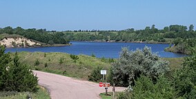
Lake Alvin is an artificial lake in Lincoln County, South Dakota between Harrisburg, South Dakota and Granite, Iowa. The lake is formed by a dam on Nine Mile Creek just before it enters the Big Sioux River, east of Harrisburg. It is part of a 59-acre (240,000 m2) recreational area.

The South Dakota Department of Game, Fish, and Parks (GFP) is the U.S. State of South Dakota's State Agency charged with the management of the state's public recreational and outdoor resources. The GFP manages the 13 State Parks and 43 State Recreation Areas within the South Dakota State Parks System, totaling over 96,000 acres of public lands. The agency manages the hunting of game and the state's fisheries, manages several wildlife management areas and game production areas to restore or establish habitat for a variety of species. The agency conducts public outdoor education programs, typically focusing on hunting and boating safety. The department issues hunting and fishing licenses along with issuance of boat registrations. The agency is also charged with enforcement of fish and game laws, including invasive species regulations. The agency is headquartered in Pierre, South Dakota.

Chief White Crane Recreation Area is a state recreation area in southeastern South Dakota, United States. It is located about 5 miles (8.0 km) west of Yankton and located on the shores of the Missouri River and Lake Yankton. The recreation area is located about 1.5 miles (2.4 km) downstream of Gavins Point Dam and Lewis and Clark Lake.
Pierson Ranch Recreation Area is a state recreation area in Yankton County, South Dakota in the United States. The recreation area is 60 acres (24 ha) and lies directly below Gavins Point Dam and Lewis and Clark Lake and is adjacent to Lake Yankton. The area is open for year-round recreation including camping, swimming, fishing, hiking and boating. It is 4 miles (6.4 km) west of Yankton.
Big Sioux Recreation Area is a South Dakota state recreation area in Minnehaha County, South Dakota in the United States. The recreation area is named for the Big Sioux River which flows through the park. The recreation area is located 4 miles east of Sioux Falls and is very popular for camping, cabin rentals, canoeing, biking, hiking, disc golf, snowmobiling and archery.
Oahe Downstream Recreation Area is a state recreation area in Stanley County, South Dakota in the United States. The recreation area is named for being immediately downstream of the Oahe Dam and Lake Oahe, a U.S. Army Corps of Engineers dam and reservoir. The recreation area is located along the Missouri River and is popular for camping, fishing and other water-based recreation. The area is located about 7 miles upstream of Pierre - the state capitol. The recreation area was constructed by the U.S. Army Corps of Engineers following construction of Oahe Dam, and legislation passed by Congress transferred ownership of the recreation area to the State of South Dakota in 2002.
Springfield Recreation Area is a state recreation area in Bon Homme County, South Dakota in the United States. The recreation area is located on the upper part of Lewis and Clark Lake, and is popular for boating, fishing, and hunting. There is a 20-site campground and a boat launch to access the lake and the Missouri River. The area is about 30 miles west of Yankton.
Lake Vermillion Recreation Area is a South Dakota state recreation area in McCook County, South Dakota in the United States. The park is open for year-round recreation including camping, swimming, fishing, hiking and boating on Lake Vermillion.

Snake Creek Recreation Area is a South Dakota state recreation area in Charles Mix County, South Dakota in the United States. The recreation area is 695 acres (281 ha) and lies along the shores of Lake Francis Case, a reservoir on the Missouri River. The area is open for year-round recreation including camping, swimming, fishing, hiking and boating. There are 115 campsites, 10 camper cabins, and a full-service marina. The recreation area is 14 miles (23 km) west of Platte.
Sandy Shore Recreation Area is a South Dakota State Recreation Area in east-central South Dakota, United States, near Watertown. The recreation area is located on the shore of Lake Kampeska, a 5,250-acre inland glacial lake. Within the recreation area is a beach, boat ramp, 17-site campground and canoe/kayak rentals. At 19 acres in size, it is South Dakota's smallest state park.
Platte Creek Recreation Area is a South Dakota state recreation area located on the eastern shore of Lake Francis Case, a Missouri River Reservoir in Gregory County, South Dakota in the United States. The recreation area is 252 acres (102 ha). The area is open for year-round recreation including camping, swimming, fishing, hiking and boating.
West Bend Recreation Area is a South Dakota State Recreation Area located along the shore of Lake Sharpe, a Missouri River Reservoir. The area is located in Hughes County. The park is open for year-round recreation including camping, horseback riding, biking, hiking and cross country skiing.