
The Sabine River is a 360-mile (580 km) long river in the Southern U.S. states of Texas and Louisiana, From the 32nd parallel north and downstream, it serves as part of the boundary between the two states and empties into Sabine Lake, an estuary of the Gulf of Mexico.

Cameron Parish is a parish in the southwest corner of the U.S. state of Louisiana. As of the 2020 census, the population was 5,617. The parish seat is Cameron. Although it is the largest parish by area in Louisiana, it has the second-smallest population in the state, ahead of only Tensas. Cameron Parish is part of the Lake Charles metropolitan statistical area.

Calcasieu Parish is a parish located on the southwestern border of the U.S. state of Louisiana. As of the 2020 census, the population was 216,785. The parish seat is Lake Charles.
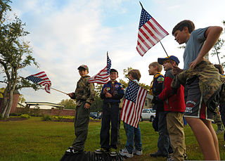
Scouting in Louisiana has a long history, from the 1910s to the present day, serving thousands of youth in programs that suit the environment in which they live.

Lake Charles is the fifth-most populous city in the U.S. state of Louisiana, and the parish seat of Calcasieu Parish, located on Lake Charles, Prien Lake, and the Calcasieu River. Founded in 1861 in Calcasieu Parish, it is a major industrial, cultural, and educational center in the southwest region of the state. As of the 2020 U.S. census, Lake Charles's population was 84,872.

Lake Pontchartrain is an estuary located in southeastern Louisiana in the United States. It covers an area of 630 square miles (1,600 km2) with an average depth of 12 to 14 feet. Some shipping channels are kept deeper through dredging. It is roughly oval in shape, about 40 miles (64 km) from west to east and 24 miles (39 km) from south to north.

The Gulf Intracoastal Waterway (GIWW) is the portion of the Intracoastal Waterway located along the Gulf Coast of the United States. It is a navigable inland waterway running approximately 1,300 mi (2,100 km) from Saint Marks, Florida, to Brownsville, Texas.
U.S. Highway 171 (US 171) is a part of the United States Numbered Highway System and the only route within that system currently located entirely within the state of Louisiana. It spans 177.44 miles (285.56 km) in a north–south direction from the junction of US 90 and Louisiana Highway 14 (LA 14) in Lake Charles to the junction of US 79/US 80 and LA 3094 in Shreveport.

In usage in the Southern United States, a bayou is a body of water typically found in a flat, low-lying area. It may refer to an extremely slow-moving stream, river, marshy lake, wetland, or creek. They typically contain brackish water highly conducive to fish life and plankton. Bayous are commonly found in the Gulf Coast region of the southern United States, especially in the Mississippi River Delta, though they also exist elsewhere.

The Calcasieu River is a river on the Gulf Coast in southwestern Louisiana. Approximately 200 miles (320 km) long, it drains a largely rural area of forests and bayou country, meandering southward to the Gulf of Mexico. The name "Calcasieu" comes from the Indian Atakapa language katkosh, for "eagle", and yok, "to cry".
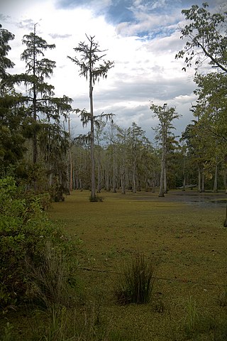
Sam Houston Jones State Park is a park near the city of Lake Charles, Calcasieu Parish, in southwestern Louisiana (USA), located where the Houston River joins the Calcasieu River and Indian Bayou. It consists of 1,087 acres (440 ha) of woodlands, lakes and rivers. Prominent in the park are many bald cypress trees. Tree-filled lagoons and a mixed pine and hardwood forest combine to create a unique natural environment. The area hosts an abundance of wildlife, including deer, squirrels, bobcats, rabbits, alligators, otters, nutria rats, raccoons, foxes and diverse bird life. Ducks and geese are usually found swimming in the ponds.

Prien Lake is a lake in Calcasieu Parish, Louisiana.

U.S. Highway 90 (US 90), one of the major east–west U.S. Highways in the Southern United States, runs through southern Louisiana for 297.6 miles (478.9 km), serving Lake Charles, Lafayette, New Iberia, Morgan City, and New Orleans. Much of it west of Lafayette and east of New Orleans has been supplanted by Interstate 10 (I-10) for all but local traffic, but the section between Lafayette and New Orleans runs a good deal south of I-10.

Louisiana Highway 82 (LA 82) is a state highway located in southern Louisiana. It runs 142.87 miles (229.93 km) in a general east–west direction from the Texas state line east of Port Arthur to the Vermilion–Lafayette parish line southwest of Youngsville.

Louisiana Highway 14 (LA 14) is a state highway located in southern Louisiana. It runs 100.10 miles (161.10 km) in an east–west direction from the junction of U.S. Highways 90 and 171 in Lake Charles to LA 182 in New Iberia.
Mossville is a small, predominantly African American unincorporated community on the outskirts of Lake Charles in Calcasieu Parish, Louisiana, United States. It is part of the Lake Charles Metropolitan Statistical Area and is sandwiched between the much larger and predominantly white towns of Sulphur to the west and Westlake to the east.

The Calcasieu River Bridge, officially named the Louisiana Memorial World War II Bridge in June 1951 is a through truss located on Interstate 10 between Lake Charles, Louisiana and Westlake, Louisiana. It was the only major bridge in Lake Charles, until the construction of the Lake Charles Loop with the I-210 Calcasieu River High Bridge began in 1962, with an average annual daily traffic (2009) of 51,800. The bridge has a vertical clearance of 135 feet. It was built under the administration of Gov. Earl K. Long and opened in 1952. It has decorative iron work with crossed guns integrated into the railings. The I-10 Bridge was originally built as the U.S. Hwy 90 bridge and later was grandfathered into Interstate 10.

Contraband Bayou is a large bayou, a tributary of the Calcasieu River. It runs through Lake Charles, Louisiana, and empties into Prien Lake.
Hayes is an unincorporated community and census-designated place (CDP) located in Calcasieu Parish, Louisiana, United States. As of the 2010 census it had a population of 780. It is part of the Lake Charles Metropolitan Statistical Area.
The Bayou Bridge Pipeline (BBP) is a 162.5-mile crude oil pipeline from Lake Charles, Louisiana to St. James, Louisiana by Bayou Bridge, LLC, a subsidiary of Energy Transfer Partners. Communities directly impacted by the pipeline voiced health, economic, and environmental concerns. They filed a lawsuit in opposition to the project and asked the Army Corps of Engineers for an Environmental Impact Statement. The Corps refused to do so and approved the project on 15 December 2017. Water protectors at L'eau Est La Vie camp consistently disrupted construction of the BBP for most of 2018, causing delays and millions of dollars in added cost to the project. They raised environmental justice and social justice issues and concerns about the pipeline's contribution to climate change. The pipeline was eventually completed in April 2019.


