
Alleghany County is a county located in the U.S. state of North Carolina. As of the 2020 census, the population was 10,888. Its county seat is Sparta.

Detroit Lake is a reservoir impounded by the Detroit Dam on the North Santiam River 46 miles (74 km) southeast of Salem, Oregon, United States. The lake is adjacent to Oregon Route 22 near the city of Detroit. This mesotrophic lake stores water for use by the city of Salem and other nearby communities.

Harris Lake, or Shearon Harris Reservoir, is a reservoir in New Hill, North Carolina. The lake covers 4,100 acres (17 km2) in southwestern Wake County and southeastern Chatham County, located 220 feet above sea level. It is the source and outlet of cooling water for the Shearon Harris nuclear power plant. The lake is adjacent but not connected to B. Everett Jordan Lake. It was created by impounding Buckhorn Creek. There are two public boat ramps; one is near the southern end off North Carolina Highway 42, and the other near the northern end by Avent Ferry Road.
Bullhead Lake may refer to:
Saylorville Lake is a reservoir on the Des Moines River in Iowa, United States. It is located 11 miles (18 km) upstream from the city of Des Moines, and 214 miles (344 km) from the mouth of the Des Moines River at the Mississippi River. It was constructed as part of a flood control system for the Des Moines River as well as to aid in controlling flood crests on the Mississippi, of which the Des Moines is a tributary. The lake and dam is owned and operated by the U.S. Army Corps of Engineers, Rock Island District.

Lake Hartwell is a man-made reservoir bordering Georgia and South Carolina and encompassing parts of the Savannah, Tugaloo, and Seneca rivers. Lake Hartwell is one of the Southeastern United States' largest recreation lakes. The lake was created by the construction of the Hartwell Dam, completed in 1962 and located on the Savannah River seven miles (11 km) below the point at which the Tugaloo and Seneca Rivers join to form the Savannah. Extending 49 miles (79 km) up the Tugaloo and 45 miles (72 km) up the Seneca at normal pool elevation, the lake comprises nearly 56,000 acres (230 km2) of water with a shoreline of 962 miles (1,548 km). The entire Hartwell "Project" contains 76,450 acres (309 km2) of land and water. I-85 bisects Hartwell Lake and makes the area easily accessible to visitors.

Clinton Lake is a 4,900 acres (19.8 km2) reservoir located near Clinton, Illinois. The lake is a part of the Clinton Lake State Recreation Area, which encompasses 9,300 acres (37.6 km2). It was built in the 1970s as a cooling source for the Clinton Nuclear Generating Station. The lake opened in 1978.

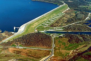
The John H. Kerr Reservoir is a reservoir along the border of the U.S. states of North Carolina and Virginia. The U.S. Army Corps of Engineers constructed the John H. Kerr Dam across the Roanoke River between 1947 and 1952 to produce hydroelectricity as well as for flood control. Kerr Lake is the largest lake in Virginia, with 850 miles (1,370 km) of shoreline located in Vance, Granville, and Warren counties in North Carolina, as well as Mecklenburg, Charlotte, and Halifax counties in Virginia. At its maximum capacity, it covers approximately 50,000 acres (200 km2) and is one of the largest reservoirs in the Southeastern United States. The name honors its Congressional sponsor, John H. Kerr, a North Carolina Democrat who supported creation of the lake. The lake supports recreational tourism in North Carolina and Virginia as described below.

Lackawanna State Park is a 1,445-acre (585 ha) Pennsylvania state park in Benton and North Abington Townships, Lackawanna County, Pennsylvania in the United States. Lake Lackawanna, a 198-acre (80 ha) man-made lake, is the central focus of recreation at the park. Lackawanna State Park is located near Dalton on Pennsylvania Route 524 just off exit 199 of Interstate 81.

Spruce Run Recreation Area is a 1,290-acre (5.2 km2) New Jersey state recreation area located in Union Township and Clinton Township in Hunterdon County, New Jersey, United States. It encompasses the Spruce Run Reservoir that is used as a backup reservoir to protect the state from prolonged droughts. The reservoir is the third largest in the state, after Round Valley and Wanaque Reservoir. The reservoir is used for recreation purposes, including hunting, fishing, boating and swimming.

Lake James is a large reservoir in the mountains of Western North Carolina which straddles the border between Burke and McDowell Counties. It is named for tobacco tycoon and benefactor of Duke University James Buchanan Duke. The lake, with surface elevation of 1200 ft, lies behind a series of 4 earthen dams. It was created by Duke Power between 1916 and 1923 as a hydro-electric project. It still generates power today and is the uppermost lake on the Catawba River system.

Roaring Gap is an unincorporated community in the Cherry Lane Township of Alleghany County, North Carolina, United States, situated near the border with Wilkes County. Home to three private golf communities, Roaring Gap is a popular summer colony.

Parker Canyon Lake is located in southeastern Arizona, 28 miles (45 km) southwest of Sierra Vista around the Huachuca Mountains and about 5 miles (8.0 km) north of the border with Mexico. The lake is a reservoir formed by a dam in Parker Canyon in the south end of the Canelo Hills in southwestern Cochise County. Parker Canyon is a tributary to the Santa Cruz River in the San Rafael Valley. The facilities are maintained by Coronado National Forest division of the USDA Forest Service.
Piney Run Park is a nature park in Sykesville, located in Carroll County, Maryland. It is Carroll County's oldest developed park and hosts thousands of visitors annually. The park encompasses 550 acres of fields, forest and open spaces, features over 15 miles of hiking trails, a 300-acre lake and many sports and recreational facilities. Prior to being a park, this land was a private farm.
Lake Streety is a natural freshwater lake in south Polk County, Florida. It is 0.4 mi (1 km) southwest of Little Sun Ray and 1.4 mi (2.3 km) southwest of Sun Ray. Both of these are small unincorporated communities. Lake Streety is just north of the Avon Park Cut Off Road and is bordered on the northeast by Lake Streety Road, which is a sand road. The lake has a 324-acre (1,310,000 m2) surface area.
Mountain Lodge Lake is not labelled on most maps, even though it is larger than some neighboring lakes. It has a 39.22-acre (158,700 m2) surface area and is roughly in the shape of an hourglass. The eastern part of the hourglass is oval-shaped. The western part is round, but considerably smaller than the eastern part. The middle of the hourglass is about a one-third as wide as the width of the other two wide parts of the lake. Mountain Lodge Lake is just north of Lake Wales, Florida. It is bounded on the east by US Highway 27, on the southeast by a vehicle dealership, on the west and southwest by a citrus orchard, on the northwest by woods and on the north by Vanguard School.
Ennice is an unincorporated community in Alleghany County, North Carolina, United States. Ennice is located on North Carolina Highway 18, 7.7 miles (12.4 km) east-northeast of Sparta. Ennice has a post office with ZIP code 28623, which opened on March 6, 1888.

High Meadows Golf and Country Club is a private golf club and residential neighborhood in Roaring Gap, North Carolina. The club is located in the Blue Ridge Mountains near the North Carolina and Virginia state borders, along U.S. Route 21.

McArthur Lake is a lake in Fort Liberty, North Carolina. It is a reservoir formed by an earth dam. The lake is used for recreational fishing.


