Lake Marcel

Last updated
Lake Marcel
USA Washington relief location map.jpg
Red pog.svg
Lake Marcel
Location King County, Washington,
United States
Coordinates 47°41′38″N121°54′54″W / 47.69389°N 121.91500°W / 47.69389; -121.91500 (Lake Marcel (King County)) Lake; [1]
47°41′35″N121°55′4″W / 47.69306°N 121.91778°W / 47.69306; -121.91778 (Lake Marcel dam and reservoir (King County, Washington)) Dam [2] and reservoir [3]
47°41′40″N121°55′16″W / 47.69444°N 121.92111°W / 47.69444; -121.92111 (Lake Marcel PP (King County)) Populated place; [4]
47°41′33″N121°54′54″W / 47.69250°N 121.91500°W / 47.69250; -121.91500 (Lake Marcel CDP (King County, Washington)) Census Designated Place [5]
Type lake, reservoir
Primary inflows Stillwater Creek
Primary outflows Stillwater Creek
Catchment area 1,290 acres (520 ha)
Basin  countriesUnited States
Surface area33 acres (13 ha)
Max. depth17 ft (5.2 m)
Surface elevation295 ft (90 m) [1] [2] [3]
Settlements Carnation

Lake Marcel is a private reservoir and community [4] in unincorporated Carnation, Lake Marcel-Stillwater, [5] King County, Washington, United States, in the foothills of the Cascades.

Contents

Lake Marcel has a surface area of 33 acres (130,000 m2) and a watershed of 1,290 acres (5.2 km2). It has a maximum depth of 17 feet (5.2 m). [6]

Lake Marcel is at an altitude of 295 feet (90 m) above sea level. [1] The lake sits in a bowl at the top of Stillwater Hill on the east side of the Snoqualmie Valley, north of Carnation. It has two main areas of water connected by a channel, and several peninsular features make an extensive shoreline around the lake.

Watershed

According to the Lake Marcel Community Club, there are "six identifiable inlet streams flowing into the lake; the largest one, Stillwater Creek, originates about 1.5 miles to the north." [7] Lake Marcel is drained solely by Stillwater Creek, named for the historic community downstream at the base of Stillwater Hill. Near Stillwater, the creek briefly joins Harris Creek before meeting the Snoqualmie River in an area protected by the 456-acre (1.85 km2)Stillwater Wildlife Area, owned by the Washington State Department of Fish and Wildlife. [8] The 44-acre (180,000 m2)Stillwater Natural Area, owned by King County, is adjacent. The portion of Stillwater Creek below Lake Marcel is also labeled as Essency Creek on some maps and government databases.

Lake Marcel is the third largest lake by surface area in Carnation, after Lake Joy with 105 acres (0.42 km2) and Lake Langlois with 39 acres (160,000 m2). However, Lake Marcel has the largest watershed of the three lakes, far exceeding Lake Joy at 468 acres (1.89 km2) and Lake Langlois at 226 acres (0.91 km2). [9]

History

Originally a beaver pond, the lake and surrounding acreage was residentially developed in the early 1960s by Pyramid Investment Company of Bellevue, Washington. [10] An island at the north end of the lake was formed by bulldozing during the excavation of the lake.

During construction, one of the principal builders -Marcel Hos- was injured and subsequently died from his injuries. He was buried in the cemetery in Carnation, and the lake was named for him.

[11] A concrete-lined fish ladder for the inflow from Stillwater Creek was built around 1963. [11] An earthen dam was completed in 1964. [12]

Community growth

In 1985, Duvall-King County Fire District #45 built the Lake Marcel Fire Station, now a vehicle station for King County Water District #119.

In 1989, Riverview School District #407 opened Stillwater Elementary School—named after the historic Stillwater School—close to Lake Marcel. [13] It is the district's only public school in an unincorporated area.

Dam

A concrete dam engineered by the United States Army Corps of Engineers was built in the 1980s [11] by the Lake Marcel Community Club (LMCC) to replace the earthen dam.

The Lake Marcel Dam is regulated by the Washington State Department of Ecology [12] and is privately owned by members of the LMCC. It is the only dam in Carnation, according to the Inventory of Dams in the State of Washington. [14]

The Lake Marcel Dam is 24 feet (7.3 m) high and 100 feet (30 m) long. It is capable of storing 350 acre-feet (430,000 m3) in Lake Marcel and can discharge 1,300 cubic feet (37 m3) per second. [12]

Comparison to other dams in the area

The Loutsis Dam in Duvall is 22 feet (6.7 m) high and 395 feet (120 m) long. It can store 138 acre-feet (170,000 m3) in Loutsis Lake and can discharge 97 cubic feet (2.7 m3) per second. [15]

The Lake Margaret Dam in Duvall is 39 feet (12 m) high and 480 feet (150 m) long. It can store 1,200 acre-feet (1,500,000 m3) in Lake Margaret and can discharge 900 cubic feet (25 m3) per second. [16]

Population

The Lake Marcel-Stillwater census-designated place (CDP) represents the immediate area around Lake Marcel. It is the only CDP between Carnation and Duvall.

The Lake Marcel-Stillwater CDP is similar in size to Carnation and Fall City, both in the Snoqualmie Valley. In 2000, the Lake Marcel-Stillwater CDP had a population of 1,381 over 1.3 square miles (3.4 km2). Fall City had a population of 1,638 over 1.3 square miles (3.4 km2). Carnation had 1,893 over 1.1 square miles (2.8 km2).

Homeowners Association

The Lake Marcel Community Club enforces regulations on the properties within its area of Plat and Dedication recognized by King County. LMCC maintains the dam, fish ladder, and 2 private beaches.

Related Research Articles

<span class="mw-page-title-main">Yakima River</span> River in Washington state, United States

The Yakima River is a tributary of the Columbia River in south central and eastern Washington state, named for the indigenous Yakama people. Lewis and Clark mention in their journals that the Chin-nâm pam called the river Tâpe têtt, possibly from the French tape-tête, meaning "head hit". The length of the river from headwaters to mouth is 214 miles (344 km), with an average drop of 9.85 feet per mile (1.866 m/km). It is the longest river entirely in Washington state.

<span class="mw-page-title-main">Carnation, Washington</span> City in Washington, United States

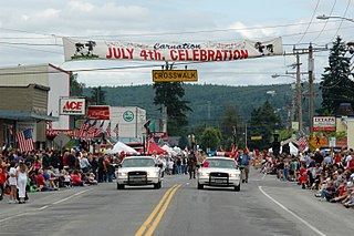
Carnation is a city in King County, Washington, United States. The population was 2,158 at the 2020 census. It was historically known as Tolt and lies at the confluence of the Snoqualmie and Tolt rivers. The city is located east of Redmond and south of Duvall on State Route 203.

<span class="mw-page-title-main">Lake Marcel-Stillwater, Washington</span> Census-designated place in Washington, United States

Lake Marcel-Stillwater is a census-designated place (CDP) in King County, Washington, United States. The population was 1,277 at the 2010 census.

<span class="mw-page-title-main">Lake Sammamish</span> Lake in King County, Washington, US

Lake Sammamish is a freshwater lake 8 miles (13 km) east of Seattle in King County, Washington, United States. The lake is 7 miles (11 km) long and 1.5 miles (2 km) wide, with a maximum depth of 105 feet (32 m) and a surface area of 8 sq mi (21 km2). It lies east of Lake Washington and west of the Sammamish Plateau, and stretches from Issaquah in the south to Redmond in the north. At Issaquah it is fed by Issaquah Creek, and at Redmond it drains to Lake Washington via the Sammamish River, named after the native people who once lived along its entire length.

<span class="mw-page-title-main">Snoqualmie River</span> River in northwest Washington, United States

The Snoqualmie River is a 45-mile (72 km) long river in King County and Snohomish County in the U.S. state of Washington. The river's three main tributaries are the North, Middle, and South Forks, which drain the west side of the Cascade Mountains near the town of North Bend and join near the town of Snoqualmie just above the Snoqualmie Falls. After the falls the river flows north through rich farmland and the towns of Fall City, Carnation, and Duvall before meeting the Skykomish River to form the Snohomish River near Monroe. The Snohomish River empties into Puget Sound at Everett. Other tributaries of the Snoqualmie River include the Taylor River and the Pratt River, both of which enter the Middle Fork, the Tolt River, which joins at Carnation, and the Raging River at Fall City.

<span class="mw-page-title-main">Mount Baker–Snoqualmie National Forest</span> Protected area in the United States

The Mount Baker–Snoqualmie National Forest in Washington is a National Forest extending more than 140 miles (230 km) along the western slopes of the Cascade Range from the Canada–US border to the northern boundary of Mount Rainier National Park. Administered by the United States Forest Service, the forest is headquartered in Everett. There are local ranger district offices in North Bend and Skykomish.

<span class="mw-page-title-main">Caesar Creek State Park</span> State park in Ohio, United States

Caesar Creek State Park is a public recreation area located in southwestern Ohio, five miles (8 km) east of Waynesville, in Warren, Clinton, and Greene counties. The park is leased by the State from the U.S. Army Corps of Engineers, who in the 1970s erected a dam on Caesar Creek to impound a 2,830-acre (1,150 ha) lake. The total park area, including the lake, is 7,530-acre (3,050 ha).

<span class="mw-page-title-main">Alpine Lakes Wilderness</span> Wilderness area in Washington (state)

The Alpine Lakes Wilderness is a large wilderness area spanning the Central Cascades of Washington state in the United States. The wilderness is located in parts of Wenatchee National Forest and Snoqualmie National Forest, and is approximately bounded by Interstate 90 and Snoqualmie Pass to the south and U.S. Route 2 and Stevens Pass to the north. The Alpine Lakes is the largest wilderness area near the population centers of Puget Sound, counted at 414,161 acres (167,605 ha) following the 2014 expansion.

<span class="mw-page-title-main">Meadow Branch</span> River in West Virginia, United States

Meadow Branch is a 16.7-mile-long (26.9 km) tributary stream of Sleepy Creek in West Virginia's Eastern Panhandle region. It passes through the Sleepy Creek Wildlife Management Area, where it is dammed to form the 205-acre (0.83 km2) Sleepy Creek Lake.

<span class="mw-page-title-main">Baker River (Washington)</span> River in Washington, United States

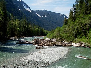
The Baker River is an approximately 30-mile (48 km), southward-flowing tributary of the Skagit River in northwestern Washington in the United States. It drains an area of the high North Cascades in the watershed of Puget Sound north of Seattle, and east of Mount Baker. With a watershed of approximately 270 square miles (700 km2) in a complex of deep valleys partially inside North Cascades National Park, it is the last major tributary of the Skagit before the larger river reaches its mouth on Skagit Bay. The river flows through Concrete, Washington, near its mouth and has two hydroelectric dams owned by Puget Sound Energy.

<span class="mw-page-title-main">Swartswood State Park</span> State park in Sussex County, New Jersey

Swartswood State Park is a 3,460-acre (14.0 km2) protected area located in the Swartswood section of Stillwater and Hampton townships in Sussex County, New Jersey, in the United States. Established in 1915 by the state's Forest Park Reservation Commission, it was the first state park established by the state of New Jersey for the purposes of recreation at the state's third-largest freshwater lake. Today, Swartswood State Park is operated and maintained by the New Jersey Division of Parks and Forestry.

<span class="mw-page-title-main">Washington State Route 203</span> Highway in Washington

State Route 203 (SR 203) is a state highway in the U.S. state of Washington that traverses part of King and Snohomish counties. It runs north–south through the Snoqualmie Valley, connecting Fall City, Carnation, Duvall, and Monroe. The highway terminates to the south at a roundabout with SR 202 near Fall City and to the north at a junction with U.S. Route 2 (US 2) in Monroe.

<span class="mw-page-title-main">Chatfield Reservoir</span> Reservoir in Colorado, U.S.

Chatfield Dam and Reservoir is a dam and artificial lake located on the South Platte River, south of Littleton, Colorado. The dam and reservoir were built by the United States Army Corps of Engineers as a response to the disastrous flood of 1965. In addition to its primary purpose of flood control, it serves as one of many water supply reservoirs for the city of Denver, Colorado. In 1966, the U.S. Atomic Energy Commission projected a total federal cost of $74 million. Construction of the project was begun in 1967 and the dam was completed in 1975.

<span class="mw-page-title-main">Snoqualmie Valley Regional Trail</span>

The Snoqualmie Valley Regional Trail is a rail trail in King County, Washington. The 29-mile (47 km) trail follows a portion of the former alignment of the Milwaukee Road, which was constructed in 1911 and abandoned in 1973.

The Central Utah Project is a US federal water project that was authorized for construction under the Colorado River Storage Project Act of April 11, 1956, as a participating project. In general, the Central Utah Project develops a portion of Utah's share of the yield of the Colorado River, as set out in the Colorado River Compact of 1922.

<span class="mw-page-title-main">Lake Shannon</span> Reservoir in Washington, US

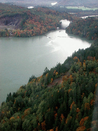
Lake Shannon is a long, narrow reservoir on the Baker River in Skagit County, Washington in the United States. Formed in the 1920s by the construction of an arch dam just above the town of Concrete, the lake is approximately 7.5 miles (12 km) long and averages 0.6 miles (1 km) wide when full. Located just outside the western boundary of North Cascades National Park, Lake Shannon serves as the lower reservoir for Puget Sound Energy's Baker River Hydroelectric Project.

<span class="mw-page-title-main">Baker Lake (Washington)</span> Reservoir in the United States

Baker Lake is a lake in northern Washington state in the United States. The lake is situated in the Mount Baker-Snoqualmie National Forest and Baker River valley southwest of North Cascades National Park and is fed by the Baker River along with numerous smaller tributaries. The lake is approximately 10 miles (16 km) north of the town of Concrete, Washington.

<span class="mw-page-title-main">Antelope Dam (California)</span> Dam in Plumas County, California

Antelope Dam or Antelope Valley Dam is a dam in Plumas County, California, part of the California State Water Project.

Highlandtown Lake is a man-made lake located in Washington Township, Columbiana County, Ohio. It was created in 1966 when the State of Ohio built a dam impounding 170 acres (0.69 km2) of water on the upper drainage of the Little Yellow Creek. A lot of habitat improvement was done on what would be the bottom of the lake prior to the impoundment. It has about 5 miles (8.0 km) of shoreline and a maximum depth of about 26 feet (7.9 m). The lake is about 1,100 feet (340 m) above sea level.

References

  1. 1 2 3 "Lake Marcel". Geographic Names Information System . United States Geological Survey, United States Department of the Interior . Retrieved 2009-05-04.
  2. 1 2 "Lake Marcel dam". Geographic Names Information System . United States Geological Survey, United States Department of the Interior . Retrieved 2009-05-04.
  3. 1 2 "Lake Marcel". Geographic Names Information System . United States Geological Survey, United States Department of the Interior . Retrieved 2009-05-04.
  4. 1 2 "Lake Marcel". Geographic Names Information System . United States Geological Survey, United States Department of the Interior . Retrieved 2009-05-04.
  5. 1 2 "Lake Marcel-Stillwater Census Designated Place". Geographic Names Information System . United States Geological Survey, United States Department of the Interior . Retrieved 2009-05-04.
  6. Lake Marcel: King County Department of Natural Resources and Parks Water and Land Resources Division
  7. "Lake Statistics".
  8. Stillwater Wildlife Area: Washington State Department of Fish and Wildlife
  9. Lakes Data and Descriptions: King County Department of Natural Resources and Parks Water and Land Resources Division
  10. Bylaws and Covenants
  11. 1 2 3 Lake Marcel Information: Lake Marcel Community Club
  12. 1 2 3 Lake Marcel Dam: National Inventory of Dams Archived 2008-05-02 at the Wayback Machine
  13. Stillwater Elementary School
  14. Inventory of Dams in the State of Washington, Washington State Department of Ecology
  15. Loutsis Dam: National Inventory of Dams Archived 2008-05-02 at the Wayback Machine
  16. Lake Margaret Dam: National Inventory of Dams Archived 2008-05-02 at the Wayback Machine
Map all coordinates using: OpenStreetMap  
Download coordinates as: KML