
Puget Sound is a sound of the Pacific Northwest, an inlet of the Pacific Ocean, and part of the Salish Sea. It is located along the northwestern coast of the U.S. state of Washington. It is a complex estuarine system of interconnected marine waterways and basins, with one major and two minor connections to the open Pacific Ocean via the Strait of Juan de Fuca—Admiralty Inlet being the major connection and Deception Pass and Swinomish Channel being the minor.

Bellingham is the most populous city in, and county seat of Whatcom County in the U.S. state of Washington. It lies 21 miles (34 km) south of the U.S.–Canada border and in between Vancouver, British Columbia and Seattle.

Whatcom County is a county located in the northwestern corner of the U.S. state of Washington, bordered by the Lower Mainland of British Columbia to the north, Okanogan County to the east, Skagit County to the south, San Juan County across Rosario Strait to the southwest, and the Strait of Georgia to the west. Its county seat and largest population center is the coastal city of Bellingham, comprising the Bellingham, WA Metropolitan Statistical Area, and as of the 2020 census, the county's population was 226,847.

Fairhaven was a settlement in Washington state founded in 1883 by Dan Harris. In 1903, it became part of the city of Bellingham.

The Truckee River is a river in the U.S. states of California and Nevada. The river flows northeasterly and is 121 miles (195 km) long. The Truckee is the sole outlet of Lake Tahoe and drains part of the high Sierra Nevada, emptying into Pyramid Lake in the Great Basin. Its waters are an important source of irrigation along its valley and adjacent valleys.

Lake Whatcom is located in Whatcom County, Washington, United States. It is the drinking water source for approximately 85,000 residents in the city of Bellingham as well as Whatcom County. It is approximately 10 miles (16 km) in length and 1 mile (1.6 km) in width at its widest. Lake Whatcom is located and managed within three political jurisdictions: the city of Bellingham, Whatcom County, and the Lake Whatcom Water and Sewer District. The lake is a popular area for motor boating, swimming, fishing, and other recreational activities.

Lake Samish is a lake south of Bellingham, Washington, United States.

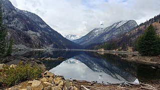
The Stehekin River is a river located in Washington state in the Pacific Northwest of the United States. It is the main river flowing into Lake Chelan. Miners arrived in Stehekin River Valley in the late 19th century. They were followed by homesteaders in the early 20th century. Today, the Stehekin River Valley is still a remote area that can only be reached by way of a 55-mile boat ride up Lake Chelan.

State Route 11 (SR 11) is a 21.28-mile (34.25 km) long state highway that serves Skagit and Whatcom counties in the U.S. state of Washington. SR 11, known as Chuckanut Drive, begins at an interchange with Interstate 5 (I-5) north of Burlington and continues northwest through several small towns and the Chuckanut Mountains to the Fairhaven district of Bellingham, where the highway turns east and ends again at I-5.

The Enchantments is a region within the Alpine Lakes Wilderness area of Washington state's Cascade Mountain Range. At an elevation of 4,500 feet, it is home to over 700 alpine lakes and ponds surrounded by the vast peaks of Cashmere Crags, which rate among the best rock-climbing sites in the western United States. The highest peak, Dragontail Peak, stretches 8,840 feet high. The Enchantments is located 15 miles southwest of the popular Bavarian-themed town Leavenworth, Washington in the United States and is regarded as one of the most spectacular regions in the Cascade Range.

Larrabee State Park is a public recreation area located on Samish Bay on the western side of Chuckanut Mountain, 6 mi (9.7 km) south of the city of Bellingham, Washington. It was created in 1915 as Washington's first state park. The park covers 2,748 acres (1,112 ha) and features fishing, boating, and camping as well as mountain trails for hiking and biking. It is managed by the Washington State Parks and Recreation Commission.

Little Seneca Lake is a reservoir located near the Boyds community in Montgomery County, Maryland.

Lake Aldwell was a reservoir located about 4.9 miles (7.9 km) from the mouth of the Elwha River on the Olympic Peninsula in the U.S. state of Washington. The reservoir was created in 1913 behind the Elwha Dam, which was fully removed in 2012. The Elwha Dam blocked at least 70 miles (110 km) of fish habitat for Pacific Salmon and steelhead within Olympic National Park.
The history of Bellingham, Washington, as it is now known, begins with the settling of Whatcom County in the mid-to-late 19th century.

Scott Lake is a lake in Thurston County, Washington, United States. It is located 3.2 miles (5.1 km) south of the Tumwater city limits, 8.4 miles (13.5 km) south of the Olympia city limits, and 14.1 miles (22.7 km) north of the Centralia city limits. The location for Scott Lake is in Sections 33 and 34, Township 17N, Range 2W, Willamette Meridian.

Arbuthnot Lake, Arbuthnet Lake, or Lower Chain Lake is a lake in the Mount Baker Wilderness Area, in Whatcom County, Washington, United States. It is one of the Galena Chain lakes. At one end of the lake is "Arbuthnot Falls". The lake was named in 1906.

Cheney Reservoir is a reservoir on the North Fork Ninnescah River in Reno, Kingman, and Sedgwick counties of Kansas in the United States. Built and managed by the U.S. Bureau of Reclamation for local water supply, it is also used for flood control and recreation. Cheney State Park is located on its shore.

Walupt Lake is a large freshwater lake located in the Gifford Pinchot National Forest in the Cascade Mountains of Washington. It is located near the town of Packwood and is popular for camping, boating, and hiking. The eastern half of the lake is within the Goat Rocks Wilderness. It is the deepest and second largest natural lake in Lewis County.
Eightmile Lake is a reservoir lake located on the eastern slope of Eightmile Mountain, in Chelan County in Washington. It is a reservoir lake formed along the beginning route of Eightmile Creek as it exits Jack Ridge.


