
Stephens County is a county in the northeastern part of the U.S. state of Georgia, in the Piedmont and near the foothills of the Blue Ridge Mountains. It is bounded by the Tugaloo River and Lake Hartwell on the east. As of the 2020 census, the population was 26,784. The county seat is Toccoa.

The Savannah River is a major river in the Southeastern United States, forming most of the border between South Carolina and Georgia. Two tributaries of the Savannah, the Tugaloo River and the Chattooga River, form the northernmost part of the state border. The Savannah River drainage basin extends into the southeastern side of the Appalachian Mountains just inside North Carolina, bounded by the Eastern Continental Divide. The river is around 301 miles (484 km) long. The Savannah was formed by the confluence of the Tugaloo River and the Seneca River. Today this confluence is part of Lake Hartwell. The Tallulah Gorge is located on the Tallulah River, a tributary of the Tugaloo River that forms the northwest branch of the Savannah River.

The Chattahoochee River forms the southern half of the Alabama and Georgia border, as well as a portion of the Florida and Georgia border. It is a tributary of the Apalachicola River, a relatively short river formed by the confluence of the Chattahoochee and Flint rivers and emptying from Florida into Apalachicola Bay in the Gulf of Mexico. The Chattahoochee River is about 430 miles (690 km) long. The Chattahoochee, Flint, and Apalachicola rivers together make up the Apalachicola–Chattahoochee–Flint River Basin. The Chattahoochee makes up the largest part of the ACF's drainage basin.

Lake Strom Thurmond, officially designated J. Strom Thurmond Reservoir at the federal level, and Clarks Hill Lake by the state of Georgia, is a man-made reservoir at the border between the U.S. states of Georgia and South Carolina in the Savannah River Basin.

The Tallulah River is a 47.7-mile-long (76.8 km) river in Georgia and North Carolina. It begins in Clay County, North Carolina, near Standing Indian Mountain in the Southern Nantahala Wilderness and flows south into Georgia, crossing the state line into Towns County. The river travels through Rabun County and ends in Habersham County. It cuts through the Tallulah Dome rock formation to form the Tallulah Gorge and its several waterfalls. The Tallulah River intersects with the Chattooga River to form the Tugaloo River at Lake Tugalo in Habersham County. It joins South Carolina's Seneca River at Lake Hartwell to form the Savannah River, which flows southeastward into the Atlantic Ocean.

The Catawba River is a major river located in the Southeastern United States. It originates in Western North Carolina and flows into South Carolina, where it later becomes known as the Wateree River. The river is approximately 220 miles (350 km) long. It rises in the Appalachian Mountains and drains into the Piedmont, where it has been impounded through a series of reservoirs for flood control and generation of hydroelectricity. The river is named after the Catawba tribe of Native Americans, which lives on its banks. In their language, they call themselves "yeh is-WAH h’reh", meaning "people of the river."

The Chattooga River is the main tributary of the Tugaloo River.
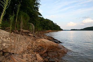
The Tugaloo River is a 45.9-mile-long (73.9 km) river that forms part of the border between the U.S. states of Georgia and South Carolina. It was named for the historic Cherokee town of Tugaloo at the mouth of Toccoa Creek, south of present-day Toccoa, Georgia and Travelers Rest State Historic Site in Stephens County, Georgia.
The Treaty of Beaufort, also called the Beaufort Convention, is the treaty that originally set the all-river boundary between the U.S. states of Georgia and South Carolina. It was named for Beaufort, South Carolina, where it was signed in 1787.

Lake Hartwell is a man-made reservoir bordering Georgia and South Carolina and encompassing parts of the Savannah, Tugaloo, and Seneca rivers. Lake Hartwell is one of the Southeastern United States' largest recreation lakes. The lake was created by the construction of the Hartwell Dam, completed in 1962 and located on the Savannah River seven miles (11 km) below the point at which the Tugaloo and Seneca Rivers join to form the Savannah. Extending 49 miles (79 km) up the Tugaloo and 45 miles (72 km) up the Seneca at normal pool elevation, the lake comprises nearly 56,000 acres (230 km2) of water with a shoreline of 962 miles (1,548 km). The entire Hartwell "Project" contains 76,450 acres (309 km2) of land and water. I-85 bisects Hartwell Lake and makes the area easily accessible to visitors.
The Keowee River is created by the confluence of the Toxaway River and the Whitewater River in northern Oconee County, South Carolina. The confluence is today submerged beneath the waters of Lake Jocassee, a reservoir created by Lake Jocassee Dam.
The Seneca River is created by the confluence of the Keowee River and Twelvemile Creek in northwestern South Carolina, downriver from Lake Keowee near Clemson. It is now entirely inundated by Lake Hartwell, and forms a 21-mile-long (34 km) arm of the lake. The Seneca River and the Tugaloo River join to form the Savannah River.
Isunigu was a Cherokee town on the Keowee River. It was on the west side of the Keowee River, near the mouth of Coneross Creek, in today's Oconee County, South Carolina. Present-day Clemson and Seneca, South Carolina later developed near here.
Tugaloo was a Cherokee town located on the Tugaloo River, at the mouth of Toccoa Creek. It was south of Toccoa and Travelers Rest State Historic Site in present-day Stephens County, Georgia. Cultures of ancient indigenous peoples had occupied this area, and those of the South Appalachian Mississippian culture built a platform mound and village here. It was an administrative and ceremonial center for them.
Georgia Power is an electric utility headquartered in Atlanta, Georgia, United States. It was established as the Georgia Railway and Power Company and began operations in 1902 running streetcars in Atlanta as a successor to the Atlanta Consolidated Street Railway Company.
Lake Tugalo is a 597-acre (2.42 km2) reservoir with 18 miles (29 km) of shoreline located in the northeastern Georgia in Habersham and Rabun counties, but also lies partially in Oconee County, South Carolina. It is the fifth lake in a six-lake series created by hydroelectric dams operated by Georgia Power that follows the original course of the Tallulah River. The series starts upstream on the Tallulah River with Lake Burton followed by Lake Seed, Lake Rabun, Lake Tallulah Falls and Lake Tugalo, ending with Lake Yonah. The western arm of Lake Tugalo is filled by the Tallulah River and the eastern arm is filled by the Chattooga River. Georgia Power considers the lake full at a surface elevation of 891.5 feet (271.7 m).
The Battle of Taliwa was fought in Ball Ground, Georgia, in 1755. The battle was part of a larger campaign of the Cherokee against the Muscogee Creek people, where a contingent of 500 Cherokee warriors led by war chief Oconostota defeated the Muscogee Creek people and pushed them south from their northern Georgia homelands, allowing the Cherokee to begin settling in the region.

Northeast Georgia is a region of Georgia in the United States. The northern part is also in the north Georgia mountains, while the southern part is still hilly but much flatter in topography. Northeast Georgia is also served by the Asheville/Spartanburg/Greenville/Anderson market.
The Chauga River is a 31.3-mile-long (50.4 km) tributary of the Tugaloo River in Oconee County, South Carolina.
The Chauga Mound (38OC1) is an archaeological site once located on the northern bank of the Tugaloo River, about 1,200 feet (370 m) north of the mouth of the Chauga River in present-day Oconee County, South Carolina. The earthen platform mound and former village site were inundated by creation of Lake Hartwell after construction of the Hartwell Dam on the Savannah River, which was completed in 1962.

