This article needs additional citations for verification .(June 2020) |
A land district is a type of administrative division in some countries.
This article needs additional citations for verification .(June 2020) |
A land district is a type of administrative division in some countries.
The lands administrative divisions of New South Wales refers to the 141 counties within the Colony of New South Wales, that later became the Australian state of New South Wales.
Land districts are the cadastral system underlying land titles in the province, and used by the provincial gazetteer in descriptions of landforms, administrative areas, and other information. Those on Vancouver Island were established via a Lands Act of the government of the Colony of Vancouver Island, from 1843 onwards; those on the Mainland were established by the Lands Act of 1860 by the Colony of British Columbia. [1]
The land districts of New Zealand are the cadastral divisions of New Zealand, which are used on property titles. There are 12 districts, six in the North Island and six in the South Island. The land districts are similar to, but different from, the 16 local government regions. The current legislation for the land districts is the Land Transfer Act 1952.

The provinces of the Colony of New Zealand existed as a form of sub-national government. Initially established in 1846 when New Zealand was a Crown colony without responsible government, two provinces were established. Each province had its own legislative council and Governor. With the passing of the New Zealand Constitution Act 1852 the provinces were recreated around the six planned settlements or "colonies". By 1873 the number of provinces had increased to nine, but they had become less isolated from each other and demands for centralised government arose. In 1875 the New Zealand Parliament decided to abolish the provincial governments, and they came to an end in November 1876. They were superseded by counties, which were later replaced by territorial authorities.
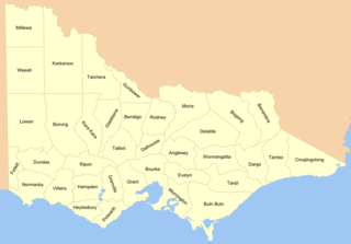
Cadastral divisions in Victoria are called counties, which are further subdivided into parishes and townships, for cadastral or land administration purposes. Cadastral divisions of county, parish and township form the basis for formal identification of the location of any piece of land in the state. There are 37 counties and 2004 parishes and 909 townships. Parishes were subdivided into sections of various sizes for sale as farming allotments, or designated as a town and then divided into sections and these subdivided into crown allotments. However, many parishes do not follow county borders, some being located in more than one county.

The history of British Columbia covers the period from the arrival of Paleo-Indians thousands of years ago to the present day. Prior to European colonization, the lands encompassing present-day British Columbia were inhabited for millennia by a number of First Nations.
The history of Australia from 1788 to 1850 covers the early British colonial period of Australia's history. This started with the arrival in 1788 of the First Fleet of British ships at Port Jackson on the lands of the Eora, and the establishment of the penal colony of New South Wales as part of the British Empire. It further covers the European scientific exploration of the continent and the establishment of the other Australian colonies that make up the modern states of Australia.

The Colony of Vancouver Island, officially known as the Island of Vancouver and its Dependencies, was a Crown colony of British North America from 1849 to 1866, after which it was united with the mainland to form the Colony of British Columbia. The united colony joined Canadian Confederation, thus becoming part of Canada, in 1871. The colony comprised Vancouver Island and the Gulf Islands of the Strait of Georgia.
The Colony of British Columbia was a British Crown Colony that resulted from the amalgamation of the two former colonies, the Colony of Vancouver Island and the mainland Colony of British Columbia. The two former colonies were united in 1866, and the united colony existed until its incorporation into the Canadian Confederation in 1871.
The Colony of British Columbia was a crown colony in British North America from 1858 until 1866 that was founded by Richard Clement Moody, who was selected to 'found a second England on the shores of the Pacific', who was Chief Commissioner of Lands and Works for British Columbia and the first Lieutenant-Governor of British Columbia. Prior to the arrival of Moody's Royal Engineers, Columbia Detachment, the Colony's supreme authority was its Governor James Douglas, who was the Governor of the neighbouring colony of Vancouver Island.

The states and territories are the second level of government of Australia. The states are administrative divisions that are self-governing polities that are partly sovereign, having ceded some sovereign rights to the federal government. They have their own constitutions, legislatures, executive governments, judiciaries and law enforcement agencies that administer and deliver public policies and programs. Territories can be autonomous and administer local policies and programs much like the states in practice, but are still legally subordinate to the federal government.

For lands administrative purposes, New South Wales is divided into 141 counties, which are further divided into parishes. The counties were first set down in the Colony of New South Wales, which later became the Australian state of New South Wales.

Lands administrative divisions of Australia are the cadastral divisions of Australia for the purposes of identification of land to ensure security of land ownership. Most states term these divisions as counties, parishes, hundreds, and other terms. The eastern states of Queensland, New South Wales, Victoria, and Tasmania were divided into counties and parishes in the 19th century, although the Tasmanian counties were renamed land districts in the 20th century. Parts of South Australia (south-east) and Western Australia (south-west) were similarly divided into counties, and there were also five counties in a small part of the Northern Territory. However South Australia has subdivisions of hundreds instead of parishes, along with the Northern Territory, which was part of South Australia when the hundreds were proclaimed. There were also formerly hundreds in Tasmania. There have been at least 600 counties, 544 hundreds and at least 15,692 parishes in Australia, but there are none of these units for most of the sparsely inhabited central and western parts of the country.
The lands administrative divisions of Western Australia refer to subdivisions of the state of Western Australia for cadastral purposes, most of which have been in place since the 19th century. The state is divided up for this purpose into five land divisions, which in turn are subdivided into land districts, which correspond to counties in other Australian states. These districts are then subdivided further into numbered locations, as well as gazetted townsites. Together, they form part of the lands administrative divisions of Australia.
Gold commissioner was an important regional administrative post in the colonies of the British Empire where extensive gold prospecting took place, including in Canada, Australia, New Zealand and in South Africa. The key responsibilities of gold commissioners were to uphold the law, provide access to the gold fields, issue mining licences, and register gold claims. Such a role was required due to the lawlessness that often followed gold rushes.
The New Westminster Land District is one of 59 land districts of British Columbia, Canada, which are the underlying cadastral divisions of that province, created with rest of those on Mainland British Columbia via the Lands Act of the Colony of British Columbia in 1860. The British Columbia government's BC Names system, a subdivision of GeoBC, defines a land district as "a territorial division with legally defined boundaries for administrative purposes". All land titles and surveys use the Land District system as the primary point of reference, and entries in BC Names for placenames and geographical objects are so listed.
The Osoyoos Division Yale Land District is one of the 59 land districts of British Columbia, Canada, which are the underlying cadastral divisions of that province. All land titles and surveys use the Land District system as the primary point of reference, and entries in BC Names for placenames and geographical objects are so listed.
The Cassiar Land District is a cadastral survey subdivision of the province of British Columbia, Canada, created with rest of those on Mainland British Columbia via the Lands Act of the Colony of British Columbia in 1860. The British Columbia government's BC Names system, a subdivision of GeoBC, defines a land district as "a territorial division with legally defined boundaries for administrative purposes". All land titles and surveys use the Land District system as the primary point of reference, and entries in BC Names for placenames and geographical objects are so listed.
The Comox Land District is one of the 59 land districts of British Columbia, Canada, which are part of the cadastral divisions of British Columbia, created with rest of those on Vancouver Island via the Lands Act of the Colony of Vancouver Island. The British Columbia government's BC Names system, a subdivision of GeoBC, defines a land district as "a territorial division with legally defined boundaries for administrative purposes". All land titles and surveys use the Land District system as the primary point of reference, and entries in BC Names for placenames and geographical objects are so listed.
The Kootenay Land District is a cadastral survey subdivision of the province of British Columbia, Canada, created with rest of those on Mainland British Columbia via the Lands Act of the Colony of British Columbia in 1860. The British Columbia government's BC Names system, a subdivision of GeoBC, defines a land district as "a territorial division with legally defined boundaries for administrative purposes" All land titles and surveys use the Land District system as the primary point of reference, and entries in BC Names for placenames and geographical objects are so listed.
The Cariboo Land District is a cadastral survey subdivision of the province of British Columbia, Canada, created with rest of those on Mainland British Columbia via the Lands Act of the Colony of British Columbia in 1860. The British Columbia government's BC Names system, a subdivision of GeoBC, defines a land district as "a territorial division with legally defined boundaries for administrative purposes" All land titles and surveys use the Land District system as the primary point of reference, and entries in BC Names for placenames and geographical objects are so listed.
The Clayoquot Land District is one of the 59 land districts of British Columbia, Canada, which are part of the cadastral divisions of British Columbia, created with rest of those on Vancouver Island via the Lands Act of the Colony of Vancouver Island. The British Columbia government's BC Names system, a subdivision of GeoBC, defines a land district as "a territorial division with legally defined boundaries for administrative purposes". All land titles and surveys use the Land District system as the primary point of reference, and entries in BC Names for placenames and geographical objects are so listed.
{{cite web}}: CS1 maint: archived copy as title (link)